HISTORY
OF
ASHLAND COUNTY, OHIO
CHAPTER III.
ASHLAND COUNTY EARTHWORKS.
A Description of the Forts.—Tyler's Fort.—Ramsey's Fort.—Metcalf's Fort.—Winbigler's Fort.—The Glenn Fort.—Gamble's Fort: —Sprott's Hill.—Bryte's Fort.—Stoner's Fort.—Shambaugh's Fort. —The Parr Fort.—Darling's Fort. —The Origin of the Works.
TYLER'S FORT
On section twenty-four, now in Wayne county, a short distance below the junction, upon th heights northeast of Tylertown, and east of the stream, is an ancient intrenchment. It overlooks the valley, which here is about one and a half miles wide, and gives an extended view, up and down the Mohican. The work is situated on an elevated spur of the ridge, on the lands of Benjamin Tyler; is circular in form, and contains about three acres. When Mr. Tyler located in 1814, he found the work destitute of grown timber. The ridge, in and about the intrenchment, had the appearance of having been often burned over. He found the embankment about four feet high, and about ten feet in diameter, at the base, and completely covered with hazel-brush, about as high as his head. He states, that he stood in the center of the work, and could overlook the Mohican valley for many miles. The work is now covered by a growth of thrifty young white oak, ranging from fifty to seventy feet in height, and ten to fifteen inches in diameter. Unlike most of the earthworks of this county, there was no spring in its immediate vicinity. From the center of the work, a grand view of the Mohican valley, for many miles dotted with fertile farms, may be had. The work was evidently one of defence, and was calculated to repel a large force, as access to it, from every side, was up a declivity.
RAMSEY'S FORT.
Ascending the Muddy fork, about fifteen miles, we find another intrenchment upon the lands of John Ramsey, on the southwest quarter of section twenty-eight, in - Jackson township. The valley of the stream, the entire distance, is very fertile and was once a favorite resort of the Delawares. This work is situated on the western side of an elevated ridge, overlooking the valley. The eastern line of the entrenchment reaches the summit facing the valley. The work is quadrangular, and estimated to contain a fraction over two acres. When first discovered, the embankment was about three feet in height, and from eight to ten in diameter at the base. The timber within the fort was equal in size to that of the forest around it, and was of the same character. The
HISTORY OF ASHLAND COUNTY, OHIO - 13
area of the fort has been cultivated about twenty-five years, and the embankment is nearly obliterated by the plow. While plowing within the fort, a highly polished stone, five inches long, two inches at the base, and one and one-half inches at the point, encircled in the middle by a groove, was found. The implement is known as the stone hammer. The ravines in the vicinity contained water sufficient to supply the wants of the fort if beleaguered by an enemy.
Two mounds were found in the north part of Perry township, about one mile from the fort. They were about thirty feet apart, and occupied level ground near a brook. The larger one was about five feet high, and twenty-five feet in diameter, at the base. The smaller one was probably twelve feet in diameter, at the base, and three and a half feet high. William Hamilton extirpated the larger one in digging a cellar; and about four feet below the natural surface found a triangular wooden post, and three human skeletons, one of unusual size, embedded in sand. On exposure the smaller ones dissolved. He also found a highly polished stone, six inches long, one and a half inches wide, and half an inch in thickness, rounded at the ends. It was converted into a whetstone by a German of the vicinity.
METCALF'S FORT.
By returning to the Jerome fork, and ascending that stream about one and a half miles, we approach a fort on the lands of the late William Metcalf, south of the stream, on an elevated plateau, facing the valley on section twenty-one. It was circular in form and contained about three acres, It was near a spring. When first discovered in the forest, in 1812, the embankments were about four feet in height, and the base about ten feet in diameter. Large trees grew in and upon the work. It commanded an extensive view. The fort at Tyler's, some four miles down the stream, could be easily seen by the naked eye. By the means of assault probably used by
L race that then inhabited these valleys, it would have h, en difficult to capture it,
WINBIGLER'S FORT.
On an elevated point, two and a half miles north, and cross the Jerome fork, was another fort on the lands of Henry Winbigler, on the northeast quarter of section nine. It contained about four acres of land, was circular in form, and was much more defensive than Met- calf's, because the ground around it was steep and more difficult of ascent, The embankments were also some- hat higher than the former work, and ten feet thick at the base. When first discovered it was covered with large timber—as sort of ridge oak, of slow growth, and must have been abandoned for a long series of years. It had a gate-way looking to the north and one to the south, and was near an excellent spring. From this fort a good view of Metcalf's was had. By the use of torches or other signals, the Tyler fort could have been alarmed at the same time. Nearly due west of this fort, on section thirteen, in Vermillion township, is a large mound which was used as a burial site by the Mohegans and Delawares; but was, doubtless, erected as a signal point by the same race that constructed the forts. West of it, about four miles, on section fourteen, and near the town of Hayesville, is another large mound, at the head of the valley reaching the Mohican. It was also most likely used as a signal point.
THE GLENN FORT.
About one and a half miles nearly east of the Winbigler fort, on an elevated plateau, is found, near the center of section eleven, a square fort, the north side being two hundred and thirty-six feet long, the east side one hundred and ninety-five, the south two hundred and six, and the west one hundred and thirty-nine feet. The north side is thirty-six feet greater than the south, and the east fifty-six feet greater than the west side, so that the square is rather oblong. There is a gate-way at the northwest corner, fifteen feet wide, with a guard or embankment extending out about thirty-five feet, which terminates in a small mound, probably the post of a sentinel. A wing about ninety feet long extends from the northeast corner, and one one hundred and fifty feet long, from the southeast corner. There is a mound a few rods southwest of the center of the work, thirty-one feet in diameter and about three and a half feet in height. This work overlooks the Tyler, Metcalf, and Winbigler forts, and gives a good view of the valley for many miles. A number of stone and flint instruments have been found in the vicinity of this work. Mr. J. N. Glenn, jr., has made, also, a curious collection of fragments of ancient pottery found in the vicinity of the fort, resembling those relics excavated from the mounds of central Ohio. In plowing he has also found many ingeniously constructed pot-holes, sufficiently large to contain eight or ten gallons of water, neatly paved with small bowlders, much burned and roasted. This may have been the work of modern tribes, but the earthworks evidently belonged to another race.
GAMBLE'S FORT.
Continuing up the Jerome fork, which rises in the summit, in the north center of the county, is- found a beautiful valley, from three to six miles wide, through which that stream meanders, fed by numerous smaller ones, on either side. As we approach Ashland, an elevated point of land, on the north of the town, on section eight, southwest quarter, is seen overlooking the whole surrounding country, for a distance of from four to seven miles. This work is above the town, and there is a gradual descent from it in all directions. It is a strong military position. The practical eye of the engineers of the ancient race that once swarmed in these valleys, selected it as a defensible position of value. A circular embankment, two thousand one hundred and forty-five feet in length, containing an area of eight and one-fourth acres, surrounded the brow of the hill. When the late Henry Gamble entered upon this land, in 1815, the fort was covered by large trees, such as were found in the forests of the neighborhood. The embankments were very nearly four feet high, in tl center, and ten or eleven feet wide at the base. The work must have required a considerable body of men a long time to con-
14 - HISTORY OF ASHLAND COUNTY, OHIO.
struct it. It had a gate-way at the southwest side, facing a deep ravine ; and near the gate, a very excellent spring. In taking the dimensions of the fort, I was assisted by Colonel George W. Urie, and Major Richard P, Fulkerson, who examined the work nearly fifty years ago, when much of the large timber was standing. The New York, Pennsylvania & Ohio railway passes down the ravine just south of the fort, and the spring now supplies the water-tank. The embankments have been plowed over for nearly fifty years, and exhibit but slight traces of their outlines.
In looking down the valley some two miles, a large mound can be seen, which has recently been opened and found to contain human bones, charcoal and woody fibre, clearly evincing the presence of fire. The mound is situated on the northeast part of section nine, and is composed of sand and drift. The excavation from which it was taken, about one hundred yards away, can be plainly seen. On section three, in a northeast direction from the above mound, about a quarter of a mile distant, near a fine spring, stood another small mound, which contained human bones, a few arrow heads and one or two stone axes and fleshers. These were turned up by the plow. The site of the mound is now obliterated. Other small mounds have been found in Montgomery township, the contents being similar to the ones described. Four miles northeast of the Gamble fort, on section twenty-eight, in Orange township, is found the Norris mound, near the village of Orange. It has been examined and found to contain human bones, large quantities of red and yellow ochre, charcoal, a few shells and a pure copper needle seven inches long, with a well-tempered point. It the forest were removed this mound could be plainly seen from the fort. It was evidently a burial site. The presence of charcoal, and the oily condition of the hard-pan, ochre and sand, would suggest that vast quantities of animal oil had been used in its sacrificial ceremonies. It may have been a signal point also. Large trees grew around and upon this mound, its height being about five feet and diameter thirty. It was evidently the work of a race that preceded the red man. This locality must have been the home of a people in advance of the Indian. Many curious relics have been found within a short distance of the mound.
About thirty-five years since, while engaged in cutting a bluff; on the bank of the creek, east of the residence of the late Patrick Murray, for the purpose of improving the trail-road alluded to, a number of human skeletons were unearthed, among which was one supposed to have been over seven (?) feet high, when erect. The bones were in a good state of preservation. This giant must have loomed up among his aboriginal kinsmen like a Colossus, as he headed their war-files along the forest paths, on the margin of the streams of this county. If he wielded authority in proportion to his immense physical dimensions, he must have more than rivalled Pipe, Logan or Tecumseh. Colonel Oldshue, who discovered the remains, found no difficulty in passing the under-jaw over his face ! The cranium and other bones showed, that this relic of another age must have been a man of unusual size and power.
In the year 185o, George Barrick, in digging a well for Isaac Stull, near his residence, half a mile south of the village of Orange, after having dug down about five feet below the surface, came upon an earthen vessel that would hold, perhaps, about two gallons. Before discovering this singular relic, he unfortunately stepped upon, and broke it. It was found mouth up, and resembled, in many respects, a two-gallon crock. The rim around the top was artistic, and intended to aid in lifting the vessel. It was formed of a bluish earth, and seemed to have been subjected to the influence of heat. It was ornamented, all over the exterior surface, by finely pulverized white flint, somewhat resembling rice grains, which adhered firmly to it. A short time afterwards, in plowing in a field, northwest Of his house, Mr. Stull turned up a fragment of the same kind of vessel, as large as his hand.
In the fall of 1872, Harvey Roberts, residing a short distance west of the Stull farm, on an elevation, just north of the creek, while engaged in excavating for the foundation of a small building, came upon two human skeletons, some three feet beneath the surface, in a sitting posture, in a good state of preservation. These remains were undoubtedly those of Wyandots, who had died during their annual residence and hunting excursions along the Mohican, over sixty years ago. Another old Indian cemetery was found, on the premises of Jacob Young, about half a mile southeast of Mr. Roberts, and many of the graves, being very shallow, were exposed, in his garden, and on the bank of the creek. The most of those on the lands of Mr. Young, we believe, were buried in a horizontal position. We do not, as yet, find the precise reason for this difference. It may be, that the parties found by Mr. Roberts may have been chiefs, or members of another tribe.
SPROTT'S HILL.
On the northeast quarter of section thirty-five, in Clear Creek township, and about two and a half miles northwest of Gamble's fort, is Sprott's hill. This hill is about ninety feet high, and contains, at its base, an area of about five acres. It is composed of alluvium, mixed with gravel and rounded boulders. The top is about sixty by ninety feet, and is nearly flat. Upon this two mounds were erected, each about twenty-five feet in diameter, and four or five feet high. When Thomas Sprott settled there, some fifty years since, large trees grew upon and about these mounds, which were about thirty feet apart. From these mounds a good view of the Gamble fort and the mound at Orange can be had.
In examining the south mound some thirty years ago, Thomas Sprott and a brother came upon a sort of stone coffin, constructed of flat stones set on the edges, which contained the skeletons of some six or eight Indians, neatly cleaned and packed, in a good state of preserva tion. On the flat stones constituting the lid of the coffin, over a peck of red vermillion was found. These relics were replaced by Mr. Sprott.
HISTORY OE ASHLAND COUNTY, OHIO - 13
BRYTE'S FORT
is situated about one and a half miles northwest of the Sprott mound, on section twenty-six. This work is quadrangular in shape. Its longest sides face the east and west, and are very nearly five hundred feet each in length, while the north and south ends are each about two hundred and fifty feet long, making the whole length of the embankment about fifteen hundred feet. Near the southwest corner was a gate-way leading to a very fine spring, some four or five rods distant. A deep ravine encircles the west side and the south end of the work, while there is a gradual descent from the north end and eastern side, showing that it was erected for defensive purposes. The view from the fort in all directions, is very fine, and takes in an area of four or five miles, The Orange mound and those of Sprott's hill, were plainly discernible. When Mr. John Bryte commenced to clear his farm some fifty-four years ago, he found large oak trees and other timber growing on the embankment, and often walked upon it in hunting squirrels. When he first saw it the walls were between three and four feet high, and perhaps ten or eleven wide at the base. He has been cultivating the fort for nearly fifty years, and the embankment is nearly obliterated. For defensive purposes the site was a good one. The water of the adjoining spring would supply a large army. It is situated on the summit, where the brooks divide to flow north to Lake Erie, and south to the White-woman, the Muskingum and the Ohio.
Many stone axes, fleshers, arrow-heads, polished and perforated stones, and pipes, have been found in the vicinity of the foregoing work.
STONER'S FORT.
Ashland county must have been, in pre-historic times, the home of a numerous people. From evidences to be found in many parts of the county, its people lived in large fortified villages, and from the nature of the places chosen for settlement, capable of making a vigorous defence against the attacks of a beleaguering enemy. High and commanding points were prepared. The localities are generally found at the head of valleys, at a prominent point; many of the ancient earthworks overlook a wide valley, and give a commanding view of the surrounding country. In this manner, no doubt, the inhabitants were enabled to detect the approach of an enemy and guard against sudden attacks and surprise. It is a curious question to determine by what means, or in what manner these villages were protected from attack and dispersion by the enemy. How were they fortified? The early French explorers say the ancient Eries, a remnant of the Mound Builders, no doubt, resided in castles or towns fortified by picket or palisade; the intrenchments were thrown up m circular or square form. This county possesses, perhaps, twelve or fifteen such works, ranging in area from two to eight acres in quantity. The remnants of these fortified places found in the forests when the first pioneers commenced to clear up the country, some seventy years since, were generally about three to five feet high in the center, and about ten feet across the base, having in many places large oak and other timber, ranging in a growth from three hundred to six hundred years. It will be easily observed that intrenchments of this kind, without pickets, would furnish no possible defence against the attacking forces of an enemy; for the red warrior could easily leap over such an earthen wall and assault the village. It is equally difficult to fix, with precision, the date of these works, and the kind of people who built them; judging from the timber and its slow growth, they may have ranged these valleys fifteen hundred years ago. It is equally difficult to determine the cause of their disappearance; they may have been succeeded by the fierce red man, or driven by force to a less rigorous climate for protection. The traditions of the Aztec race fixes their former residence in the far north, possibly in Ohio, Indiana and in Missouri, from whence they were expelled by a fiercer and more warlike race, .finally finding a home in Mexico. The habits of the red man are different; they are opposed to physical exertion, and never could have been the means of fortifying great military works. They are very warlike, full of strategy, and very destructive to their enemies. The race they expelled must have been organized into a sort of government, and either by coercion or arrest employed large numbers in the erection of their stupendous earthworks in different parts of Ohio. Many of their works seem to have been erected in the absence of timber; in fact, the whole country seems to have been almost destitute of timber, from what cause we are unable to determine. The growth of our timber has largely occurred within six hundred years. Acorns planted by design or accident, on the very intrenchments of the forts, have grown into lofty oaks, three to four feet in diameter, and perhaps six hundred years old.
With these prefatory remarks, we desire to call the attention of the pioneers to an ancient earthwork or intrenchment on lands of John and David Stoner, in southeast quarter of section twenty-eight, in Milton township. Sixty-seven years ago the pioneers of Milton had their attention drawn to this work then in the forest, and nearly as when left by those who erected and occupied it. It is a few hundred yards west of Mr. Stoner's house, and is partly within a plowed field. It forms nearly a complete circle. The length of the circle is about one thousand nine hundred feet; it contains nearly eight acres of land. The east half of the circle has been plowed over for, perhaps, forty years, and is nearly obliterated. The west half of the circle can be distinctly traced, and has many trees upon it. Among these were noticed some three or four white oaks, very tall, that are over three feet in diameter, that have grown upon the embankment, that are at least six hundred years old. In the location of the work it is surrounded by ravines east, west, and northwest, possessing sufficient water for all practical uses. Early settlers state that before the removal of the forest the work was about three feet high, and nine or ten feet at the base, and may have been originally a strong stockade, and been the residence of hundreds of people. The view from the fort is very fine; it over-
16 - HISTORY OF ASHLAND COUNTY, OHIO.
looks the valley of the Black fork to the west and northwest for a long distance. The locality in Richland county known as High Hill, comes clearly into view from the fort, and constitutes a striking feature of the landscape. This seems to be a continuation of the same class of works found on the farm of the late John Bryte, in Clear Creek township, and doubtless erected by the same race, for defensive purposes. Mr. John W. Fry of Ashland, accompanied me in viewing and taking the dimensions of the work, and is of the opinion that it was much more distinct when he first saw it, many years ago. From the fort we passed to land of Mr. Henry Pifer, about half a mile northwest, where we viewed the remains of an ancient mound, probably connected as a burial site, with the fort, in the valley, near the Black fork. While no bones have been reached in plowing, different strata of earth have been turned up, such as tough yellow clay, black, tough hard-pan and sand, and gravel in great abundance. By excavating eight or ten feet deep, it was discovered that large numbers of human bones may be found encased in muck, like those recently found in the John Green mound. In plowing farther south, along the Black fork, Mr. Pifer is of opinion that other burial places and excavations will came to light. It will then appear that to erect and complete such a village, with the mound to be used for burial purposes, it must have taken the joint labor of a vast number of men. To accomplish so much with the feeble means employed, it will appear that this county must have teemed with human beings long before the white man arrived.
SHAMBAUGH'S FORT.
Returning to the south end of the county we ascend the Black fork of Mohican. At the farm of Lewis Oliver, and one or two points below, were found mounds of five or six feet in height, and about thirty feet in diameter, at the base. A little southwest of Perrysville, on the road leading to Newville, on the summit, above the village, was a mound overlooking the valley, the size of the ones described.
Passing up the stream to near the old Indian village of Greentown, to the lands of Mr. John Shambaugh, on the north side of the stream, on section eighteen, we find another circular fort, containing very nearly two acres, with a gate-way looking to the west. In the center was a mound, about four feet high, which had probably been an altar or lookout. When first discovered, the embankment was about three and a half feet high, and ten wide at the base. It is difficult to conjecture for what purpose the work was constructed, as it was situated on the bottom, fully a quarter of a mile from the elevated lands on either side of the stream. A small brook flowed by it, from which, no doubt, water was obtained. Timber—such as oak, hickory and elm, grew upon and within the work, the larger trees being oven three feet in diameter. The lands along the streams are very fertile; and the site of the fortification having been lowed over for half a century, the embankments are merely traceable.
THE PARR FORT.
About one mile distant from the work alluded to, on section nineteen, is found what is known as the Parr fort. It is also a circular work, the embankment, when first discovered by the pioneers, being about seven feet high, and twelve or fourteen in diameter, at the base. It enclosed an area of about three acres, and had a gateway at the west. Very near it, on the east side, stood a large mound from which copper beads and stone implements have been taken.
I am informed by Dr. J. P. Henderson, of Newville, that this mound was opened some fifty years ago. In it were found human bones, charcoal, decayed wood, a stone pipe, the stem of which was wrapped with copper wire and a copper wedge. .This last produced quite a sensation at the time, as it was supposed to be gold ; but on being taken to Wooster, and examined by a silversmith, it depreciated in value, and was disposed of for a mere trifle. The mound was of peculiar structure. It was built of large flat stones in a circular form, like a shot-tower, and filled up and around with earth ; and was a cone in appearance. The fort was well situated, and should have made a good defence. Many stone axes, stone fleshers, and polished stone plates have been found in the vicinity of these works.
DARLING'S FORT.
About two and a half miles south of Parr's fort, near St. John's church, on the north bank of the Clear fork of the Mohican, is found another very strongly situated work. It is circular, and contains an area of nearly three acres. It had embankments from the gate on the south side (as I am informed), leading down to the bank of the stream. When first discovered, by Judge Peter Kinney and others, it was covered with large timber, and the embankment was over three feet high. It commands a full view of the valley for many miles, and was doubtless used as a defensive work. Many very choice stone relics have been plowed up along the valley by farmers, and are now in the cabinet of Dr. James P. Henderson, of Newville. It will be seen then, that, Green township contained three defensive works, and is rich in archaeological remains.
We find no other remains until we reach the village of Mifflin. On the level land, a little northwest of the village, is a large mound. The top is slightly flattened, and was, no doubt, used as a burial spot by the Delawares. It has not been excavated, and its contents are only a matter of conjecture. Many stone axes, stone heads, flint arrow-heads, and pick-shaped implements of stone highly finished, have been plowed up by the farmers all along the valley of the Black fork.
There are, perhaps, twenty or thirty smaller mounds scattered over the county to which my attention has not been called. The mounds of this county are invariably truncated and none exceed ten feet in height. I am inclined to the opinion that many of the smaller ones were the center of an encampment, and were erected for sacrificial purposes. Such a mound existed in the center of the council house at Greentown. The venison and bear
HISTORY OF ASHLAND COUNTY, OHIO - 17
meat, for their great feasts, was boiled in large copper keltles upon the mound. This may account for the charcoal, ashes, and charred bones so frequently found in small flat mounds: I have reason to believe, also, the tent or wigwam of the ruling chief was sometimes placed on a central mound of similar structure.
THE ORIGIN OF THE WORKS.
Two hundred and thirty years ago, when the French Jesuit missionaries, La Moyne, Father Joseph De la Roche, D'Allyon, Breboeuf, Chamount, and Sayard, were endeavoring to establish missionary stations among the Hurons, Ottawas, and the The Nations known as the Iroqouis, lhe Fries, a powerful nation, owned all the territory south and adjoining Lake Erie, and gave name to the lake. This nation was able, single-handed, to repel the assaults of the Five Nations. Its borders extended along the lake shore, from the Senecas, near Buffalo, to the Mantis, southwest of the lake, one of their fortified positions, according to Schoolcraft, being on what is now known as Kelley's Island. Like the Hurons, they are supposed to have occupied densely populated villages, well fortified by ditch and palisade. They owned the territory out of which the Western Reserve was erected, and many suppose the earthworks of this region were constructed by that people. When the missionaries were first permitted to enter the eastern part of their territory, they had twenty-eight villages, and twelve large towns or forts, which contained twelve thousand people and four thousand warriors. From 1634 to about 166o, a fierce and relentless war raged between the Fries and the Iroquois or Five Nations, in which the Iroquois finally triumphed and expelled the Fries from the country.
If it be true, as conjectured, that the Fries erected the earthworks of northern Ohio, it must have taken place about that period. If we take the growth of forest trees as evidence of so recent an occupation of these fortified places, it will make it tolerably certain that they were constructed by that nation. The peculiar structure of the embankments strengthens the supposition that they once contained a stockade. They are too low to have afforded protection in case of assault, and only upon the theory of having been palisades can we imagine they were used for military defence. If it be true, that two hundred and fifty years ago, as suggested by Mr. Shea, - the Huorns, Fries, and other nations occupied fortified places, it may be reasonably inferred that the Fries, about the beginning of the year 1600, occupied and fortified this region.
It may be said they were destitute of implements to construct such fortifications. We know not what implements were used, or how long it took to throw up such embankments, nor the number of men employed in their construction. The earth was found in situ, and only had to be heaped-against each side of a palisade. How the stakes were obtained for such a purpose is a matter of conjecture, The trees may have been f lied, and the stakes separated in suitable lengths by fire
CHAPTER IV.
THE ERIES OR THE CAT NATION.
The Aborigines of Northern Ohio.—Their Antiquity.—They Yield to the Encroachments of the Whites.----The Eastern and Western Tribes arrayed against eaeh other.—The Eries.--They give their Name to the Lake North of Ohio.—Their Works and their Character as a Nation.— Vanquished by the Iroquois.—Does a Remnant of the Tribe still exist?
Two hundred years ago the territory composing the State of Ohio was unexplored by the white man. The Indian tribes were the undisputed lords of the soil, and dwelt along its rivers and streams and fertile valleys. Although the children of the forest possessed no written records, tradition assures us that their history teemed with tragic events. We have no means of determining when the red man took possession of the lake shore, and the valleys of the Miami, the Muskingum and the Ohio. That they roamed over the hills, amid the valleys, and rowed their birch canoes upon the beautiful rivers of this State, ages before the arrival of the white man in this region, is undisputed.
Upon the appearance of the European upon the eastern shores of New England, Virginia, Maryland, Delaware, New York, and New Jersey, and his attempt to take possession of the territories inhabited by the Indian tribes, jealousies and collisions soon sprang up and culminated in a fierce and bloody border war, in which many of the most powerful Indian tribes were severely chastised, and broken in strength and numbers, and finally compelled to seek new hunting-grounds in the west.
The rivalry between Great Britain and France in establishing colonies in North America, resulted in arraying the Indian tribes of the west against those of the east, and contributed to their dispersion and final extinction in many of the older States. The tribes recognized as the original proprietors of the soil on the south shores of Lake lErie, enter chiefly into a history of the territory composing Ashland county. It is generally conceded that the Cat Nation, or Fries, sometimes called in the early annals of the country, the Kahkwahs, were once the lords of the soil of all Northern Ohio, and inhabited this region. It is the opinion of the early Jesuit missionaries, as well as of Mr. Bancroft, that the Cat, or Erie nation suggested the name of Erie, to the beautiful lake that fringes the northern border of the State. The chief seat of their power seems to have been located near the southeastern shore of Lake Erie; while the tribe had a wide range extending from the Miami of the lake to the Allegheny in western Pennsylvania, and south to central Ohio. They do not seem to have been a war-like race, but from the strength of the tribe, constituted a sort of human wall to break the incursions of the Sioux and Illinois from the west, as well as the expeditions of the Five Nations, occupying northern New York and a part of northern Pennsylvania. Occupying a sort of middle ground, and being one of the most powerful tribes in the confederacy, known as the neutral nation, they excited the jealousy and revenge of the Five Nations, and finally fell before the victorious Mohawks. The de-
18 - HISTORY OF ASHLAND COUNTY, OHIO.
tails of the struggle that led to their conquest are very obscure.* The names of the leading men, and the exact strength of the nation on the battle-field, are all buried in uncertainty. We are indebted to the early Jesuit missionaries for all the information we possess concerning the Fries.
The Canadian shores of the lake were first visited by those self-sacrificing christian messengers, with a view of propagating the tenets of the Catholic church, and the spread of French authority among the red men of the Canadian forests. They penetrated almost every portion of that region, pushing their enterprise west to Wisconsin, over the wild prairies of Illinois, to the Mississippi, to central Ohio, along the Muskingum, the Scioto, the Miami, into the wilds of Indiana to Vincennes, as well as northern New York.
The first mention of the Fries is by Father Le Moyne and Claude Dablon, in 1657, who were then missionaries among the Mohawks and Senecas of northern New York, by whom it is stated that the savage tribes composing the Five Nations were carrying on a war of extermination against the Fries, bringing back great numbers of prisoners to the villages to be delivered to the flames, or adopted into the Five Nations. This war of extermination was continued by the savage Mohawks, and their confederates, until the broken and vanquished Fries were driven back to Kelley's Island and subjugated and their way opened to the Miamis, the Illinois, and the Sioux. These authorities inform us that the Mohawks were furnished arms and ammunition to accomplish the ruin of the Eries by the British colonists, in the hope of breaking French influence among the tribes of the West. The live Nations, according to Schoolcraft, made war upon the neutral nation, west of them, composed probably of the Hurons, the Ottawas, a remnant of the Alleghans, the Andastes or Kahwahs, and the Fries; and, after the conquest cf the _Hurons, or Wyandots, then established on the borders of Lake Huron, the Five Nations invaded the Andastes and the Eries in 1655, and, after they had been forced westward to their stronghold on Kelley's Island, the relentless Iroquois, known as the Five Nations, followed them thence and laid siege, using their canoes as scaling ladders, and, leaping down like tigers among the defenders, butchered them without mercy.
The greater part of the nation was involved in the massacre, and a remnant carried back with the victors and incorporated with the conquerors or consigned to the flames, a few escaping to other tribes. This misfortune befell the poor Fries, doubtless because they were at the head of the confederation called the neutral nation. The Fries, being the head of the neutral nation were seldom engaged war with their
* Colonel Charles Whittlesey, in a letter addressed to the author, concerning the ancient Eries, and their final overthrow and dispersion says:
"I have made another effort to learn more of the Eries, whom the Iroquois exterminated between 1650 and 1655. The town which was the scene of the final battle, was somewhere in the interior of Ohio, called Kointown—probably near a river—but cannot be identified."
+ Mr. Schoolcraft's conjectures concerning the residence of the Eries on Kelley's Island are not regarded as authentic.
neighbors of the East or West ; and with the Miamis on the west, and the Andastes, their kinsmen, on the east, they held sway over the larger portion of Ohio, and pursued the buffalo, the elk, the deer, and other game through our forests and over the plains undisturbed by foreign foes, until the rage of the bloody Mohawk marked the nation for destruction. Schoolcraft is of the opinion the Fries had developed the laws of civilization so far as to desire peace with the surrounding tribes, and seemed intent on, making progress in the arts of civilized life. After their destruction by the Iroquois, it was found that their intrenchments on Kelley's Island were very strong, and of a character unlike anything found among other tribes. The intrenchments were on the southern shore of the island and were composed of two crescent shaped embankments, and seemed to be intended to Inclose and defend their villages. One of them had a front of four hundred feet, and the other six hundred and fourteen feet on the rocky margin of the lake. Adjacent is a rock thirty-two by twenty-two feet on the surface, on which a great variety of figures are deeply cut. It presents the most extensive and well sculptured inscriptions of the antiquarian period found in America. The characters are pictographic and easily interpreted. If his conjectures be correct, the ancient Fries had made greater progress in recording their history than any of the Indian tribes found in the valleys of the Ohio and Mississippi ; and their conquest by the relentless and untamed Mohawks is to be greatly regretted because they came nearer connecting the Indian tribes with the ancient Mound Builders than any of the tribes found within the limits of the State, by the first settlers and missionaries. In visiting the waters emptying into the Muskingum and the Ohio, we have no doubt the ancient Fries made Ashland county a part of the great highway leading to central Ohio. We are led to this conclusion because it was a part of their territory, and because the sides of the stream along which they must have journeyed are dotted with the relics and ruins of ancient stockades and earthworks.
In his history of the condition of the Indian tribes, part second, 86-7—he expresses the opinion that the inscriptions found on Kelley's Island allude to the occupation of that basin of the lake by the Fries, the coming of the Wyandots, of the fatal triumph of the Iroquois, and the flight of the people who have left their name to the lake. If such is a correct interpretation of the inscriptions, the _Fries were not exterminated, as some suppose, by the Iroquois; for this record must have been placed there after the conquest. General Lewis Cass,. of Michigan, concurs in this opinion, and says the Canadians term the Shawanese the "Cat Nation." He also expresses the opinion that the Kickapoos and Catawbas are remnants of the vanquished Fries. Mr. Taylor, in his history of Ohio, first part, page 520, says a people who were called Erierions by the Wyandots, and Kahkwahs by the Iroquois, may have had many other names from other tribes; and that a remnant of the nation called the "Cat" or "Fries," may still be in existence somewhere among the Indian tribes of the West.
HISTORY OF ASHLAND COUNTY, OHIO - 19
CHAPTER V.
THE WYANDOTS.
The Wyandots as Successors of the Eries.—Some Account of their Conquest and Expulsion front the Shores of Lake Huron by the Iroquois.—Their occupancy of Michigan and Northern Ohio.
About the year 1615, while engaged in establishing missions among the Indian tribes of northern New York, Father Sigard visited the Quatoghee or Wyandot nation, then occupying the southern shores of Lake Huron. At that time they called themselves Yendots, but were called Hurons by the French, because of their location on the shores of that lake. The nation at that time consisted of five confederated tribes or clans, as follows: Ataronch-ronons, four villages; the Attiquenongnahai, three villages; the Attigaouentan, twelve villages; the Ahrendah-ronons, three villages; and the Twnontate, nine villages. According to Father Gabriel Lallemand, these thirty-one villages occupied a territory of about sixty miles in extent, adjoining the Five Nations, and lying about one hundred miles south of the mouth of the Ottawa, or French river. About that time, Champlain, an eminent Frenchman who afterward became governor of Canada, spent some time with the Ahrendah-ronons, the most northeastern tribe. The Jesuit, Father Sigard, resided with the nation some years, and succeeded in making a favorable impression upon the tribes.
In 1639, the whole nation was scourged by small-pox, and about twelve hundred fell victims to that abhorrent disease. The Jesuit missionaries took advantage of the scourge, to visit every village, to administer to the wants of the afflicted, and baptize their dying children. In their labor of charity and love, they went to almost every cabin, and succeeded in influencing great numbers of Wyandots to unite with the Catholic church. They estimated the number of cabins, at that time, at seven hundred, and the number of families at two thousand, and the whole population at about twelve thousand. The year before the appearance of the small-pox, the Jesuit, Jean de Breboeuf, while a missionary among the Wyandots, near Lake Huron, became acquainted with a remarkable warrior, named Ahasistari, who related to the missionary a singular dream, concerning the white man's deity, and afterwards became a zealous member of the church. Many other Wyandots followed the example of Ahasistari, and joined the missionaries in the erection of chapels, and in the ceremonies of the church. The Wyandots willingly embraced the doctrines of the Jesuits, and made rapid advancement in civilization; particularly in agriculture, to which they paid a good deal of attention. They were more amiable than the tribes of the Five Nations, and were more readily induced to embrace the tenets of the Catholic church, as expounded by Father Breboeuf and his successors. By the advice and instruction of the missionaries, a number of churches and schools were established, in their most populous villages, and stockades erected to protect them from surprise by the Five Nations. The villages of St. Louis and St. Ignatius were esteemed the most important.
It was the custom of the Wyandots to make annual visits to Quebec, then a small French village, to consult the Jesuit teachers, exchange furs for goods, and renew their devotion to the king of France. They returned by the way of the Ottawa and the rivers that interlock with it.* Their journey was more than sixteen hundred miles, through dense forests, and along shoaly rivers; and all day long the missionaries and the Wyandots were compelled to wade or handle the oar. At night they had no food but a scanty measure of Indian corn mixed with water, and their couch was upon the earth or the rocks ! In this long journey they passed thirty-five water-falls, and carried their canoes upon their shoulders many leagues through the forests, and dragged them by hand through shallows and rapids over sharp stones ; and while thus proceeding on their journey homeward, accompanied by Father Isaac Joques, in August, 1649, a band of Mohawks, whose war parties, fearlessly strolling through the forest, were ever ready to fall suddenly upon their foes, lay in wait for the pilgrims as they ascended the St. Lawrence.[ Ahasistari, the pilot of the pilgrims, landed, and upon examination, declared there were only three canoes, and added there was nothing to fear. The party proceeded, and the Mohawks from their ambush attacked the canoes as they neared the land. Wyandots and Frenchmen alike hastened to the shore to seek security in the forest. The pious Joques might have easily escaped, but among the wounded were converts who had not yet been baptized, and caring not for his own safety, he proceeded to discharge his duty to the dying Wyandots. Ahasistari succeeded in gaining a hiding place, but observing Joques to be a captive he hastened to him, saying: " My brother, I made oath to thee that I would share thy fortune, whether death or life ; here am I to keep my vow." Joques, Rene Goupil, Ahasistari and other captives were carried through the Mohawk villages, where Goupil was tomahawked and Ahasistari suffered the most horrible tortures, and finally, death by being burned at the stake, while Joques was unexpectedly spared.
Thus a new war sprang up between the Wyandots and the Five Nations, who had long been jealous of the influence of the Wyandots with the neutral nation, and who had stood in their path to the Illinois and the Mississippi. By frequent surprises by the Mohawks, communication by the Ottawa river with Quebec was cut off, and after repeated repulses elsewhere, the Wyandots became dispirited in consequence of the loss of so many of their warriors, and abandoned the small villages and concentrated in the large ones. This seemed to exasperate the Five Nations, and the Wyandots were a doomed race. In 1654 the combined forces of the Five Nations resolved on the destruction of the Wyandots, invaded their country and attacked and took the most of their stockaded villages, and massacred large numbers of the inhabitants. The attack was renewed the next year, and the Wyandot nation was completely scattered, some seeking a refuge by the Ottawa, under the walls of Quebec, whither they were pursued
*Bancroft.
+ Father Joques, in " French Relations."
20 - HISTORY OF ASHLAND COUNTY, OHIO.
by the relentless Mohawks. Several bands were captured and incorporated in the live Nations; a remnant of the nation fled to the country of the Chippewas of Lake Superior. Other bands fled to the upper part of Michigan and other remote quarters. As we have already seen, the Five Nations then opened a war of extermination against the Andastes and the Eries. About the year 1671, that part of the Wyandot nation which had taken refuge among the Chippewas, was induced by Father Marquette to return to the Peninsula of Michigan, where they united their fortunes with a dispersed remnant of their brethren near Detroit, with perhaps a remnant of the Andastes, and the Eries, who had sought refuge in that quarter.
About the close of the thirty years' war between the French and the Five Nations, when the strength of the latter had been broken, and their incursions into Ohio successfully checked, the Wyandots took quiet possession of the ancient territory of the ill-fated Erie's, claiming sovereignty over all the country between Lake Erie and the Ohio river. We find the Wyandots, in 1740, sufficiently strong to offer an asylum on the Muskingum to a part of the Delaware nation which had fled from the intrusions of the white man in Pennsylvania.* The Wyandots, probably obtained the territory of the Fries through French influence. The Wyandots occupied a commanding influence over the western tribes as late as the treaty of Greenville. Mr. Taylor says the Wyandots dwelt upon the waters of Sandusky and Maumee in 1750. The principal seat of the nation was opposite Detroit, Michigan, and the Ohio settlements were in the nature of colonies from the peninsulas bordering on Lake Huron. The Wyandots unquestionably stood at the head of the Ohio Indians for bravery, intelligence and capability of adopting the laws of civilized life. President Harrison, who was a military officer in the northwest, became well acquainted with the Wyandots, declared that neither surprise nor sudden disaster in battle cowed their courage. At the battle of the rapids of the Miami, where he won a noted battle over the confederated tribes, he says the Wyandots lost thirteen chiefs, notwithstanding which, they fought with the most constant and unflinching courage. It was one of the characteristics of the Wyandots that they would never be taken in battle. In the appropriate place, it will be seen that they took a leading part, under British influence, in the warlike incursions in the eastern and western parts of this county, and aided in the destruction of the property of the early settlers, as well as in menacing their safety.
* Heckewelder.
NOTE.—The reader will remember that after the war of 1812-14 the Wyandots resided on their reservation at Upper Sandusky, occcupied in the pursuit of agriculture, and making considerable advancement in education and the arts of civilized life, until 1842-43, when they were assigned a new reservation by the general government, in the territory of Kansas, to which they removed, and where they now reside.
CHAPTER VI.
THE OTTAWAS.
The Ottawas and their Expulsion by the Iroquois.—Their Flight to the Upper Lakes.—Their Return to Michigan and Ohio.—As Confederates of the Hurons or Wyandots.
WHEN the Five Nations had conquered and dispersed the Wyandots in 1655, they immediately assailed the Ottawas, another branch of the neutral nation occupying the shores and islands on the Ottawa river, in Canada. The invasion was conducted by the relentless Mohawks, with their usual vigor and cruelty, until the unfortunate Ottawas, unaccustomed to war, were compelled to abandon their homes and seek refuge on the Bay of Saginaw, opposite the territory of Michigan.* Here they found the scattered Wyandots, for whom they had borne the strongest attachments; and, uniting with them, removed to the deserts north of Lake Superior in 1665, near the Chippewas, where they were visited by the Jesuit missionary, Allouez.
When first visited by the missionaries, about the year 1615, they occupied an island on the Ottawa river, as well as the territory adjacent to the river, and although disposed to be on peaceful terms with their neighbors, they exacted a sort of tribute or toll from all the Indians navigating that river, which seems to have been willingly assented to by the Wyandots and other fur-trading tribes. We may infer, therefore, that they were the original proprietors of the islands and the shores of that river. At that time their chief occupation was fishing, hunting, raising corn, and trading with the nations, using the river as a sort of commercial highway. In fact, the early missionaries supposed the term "Ottawa" originally meant in their language, a trader.
About the year 1680, La Salle a distinguished French explorer, visited the Ottawas at the Bay of Saginaw and found them and the Hurons or Wyandots, confederated against the Five Nations, and engaged in cultivating corn, which was their ordinary food, and fishing upon the borders of the lake. He purchased an abundance of "whitings" and some "trouts'" of extraordinary size of them. Father Hennepin, a Franciscan, also visited them at their new home about the same time, and joined them in fishing in the bay, by breaking holes in the ice, and by means of several large stones, sunk nets to catch fish, which he did in great abundance, and adds, "these made our Indian wheat go down the better, which was our ordinary diet." He also relates that at that time the Ottawas were greatly in dread of the Iroquois or Five Nations, who had a short time before taken an entire family of twelve souls into slavery, and otherwise greatly distressed their people, while others had fled to the French at Quebec for protection and food. It seemed difficult for the Ottawas to escape the raids and malice of the Five Nations who sought the fugitives wherever they attempted to conceal themselves. In the year 1701, after the peace between the French and the Five Nations, a settlement by the French was commenced at Detroit by De la Matte Cadillar, with a Jesuit missionary
* Bancroft.
HISTORY OF ASHLAND COUNTY, OHIO - 21
and one hundred Frenchmen. A fort was erected for the protection of the new settlers, and Detroit so0n became the center of trade with the Indians. The Ottawas and Wyandots, after a residence of over fifty years in Upper Canada, joined the new settlement by returning to its vicinity. The French were ambitious to hold the ascendency over the British in the territories of Illinois, Michigan, Indiana and Ohio, and to do so, encouraged the Wyandots and Ottawas to pass down the western shores of Lake Erie.
In the year 1750, nearly one hundred and fifty years after the expulsion of the Ottawas from the home of their fathers on the Ottawa river, we find the French engaged in constructing a fort at Sandusky. It is not known with certainty how many French occupied the new fort, but their influence was speedily seen on the Indians of Ohio, who were encouraged by presents and jealousy to make savage raids on the border settlements of Pennsylvania and Virginia. The principal settlements of the Ottawas were on the Maumee, along the lake shore, at Plym0uth, Huron county, the mouth of Huron river, on the Black river, and a large village at or near Cuyahoga Falls. After the decay of French influence in Canada, when the Ottawas and all the other northwestern tribes in Ohio gave in their adhesion to the British, and during the Revolution and the war of 1812— 15, the Ottawas were known by the first settlers of this and the surrounding counties, as "Canada Indians," and were generally adherents of the British cause ; and encouraged in their predatory incursions on the border settlements, by presents in compensation for the scalps they were able to exhibit on their return from their expeditions.
While the Ottawa nation seems to have been almost entirely destitute of great war chiefs and leaders, it must be admitted that in what may properly be termed "Indian diplomacy," it ranked as a nation or tribe with most of the Ohio Indians. In the history of Ohio, it is noticeable that the British and French often employed Ottawa emissaries to influence the other tribes to join their cause, and frequently with considerable success. As a people, the Ottawas were without true courage, and relied upon their cunning and dissemblance for success. The Wrandots were a frank, brave and fearless people, while the Ottawas were timid, treacherous and uncertain, as enemies or friends.
The only really great man ever produced among the Ottawas was the gallant war-chief, Pontiac, who was supposed to he the son of an Ojibwa woman, while his father was an Ottawa.* It is not known with certainty, whether Pontiac was b0rn during the residence of his lribe near the upper lakes, or after his people had settled on the Maumee, in Ohio. Pontiac was a strong friend of the French; and when their colonists were contending for the occupation of Michigan, the valleys of Ohio, the Wabash, and the Miami, he rallied the red men of the forest against the British, and fought with distinguished courage, side by side with the French. Watch-
* Perkins ii, 223.
ful, fearless, indomitable, he was ever on the alert to foil the advance of the "Long-knives," the Pennsylvanians and the "Red coats" aiding their advance into these territories.
When, in 1760, Canada surrendered to the English, by the French governor, Vaudrueil, Major Robert Rogers, a native of New Hampshire, and an associate of Putnam and Stark, was ordered to take possession of the western forts. * He left Montreal with two hundred rangers, well trained as hunters and woodsmen, armed like Indians, with hatchet, gun, and knife. He embarked at Presque Isle, up Lake Erie, in fifteen whale boats; and when, from bad weather, he was compelled to put into the mouth of the Geauga, or Grand, river, Ohio, he met an embassy of Ottawas, who told him the chief or king was a short distance away, coming, and desired him to halt for a talk. The request was complied with, and Pontiac met him; and, after the first salutation, demanded to know his business in his country, and wished to know how it happened that he dared to enter it without his leave ? When Major Rogers told him he had no desire to injure the Indians, but came to remove the French out of the country, Pontiac told him he stood in his path, and would give him a final answer the next day. The next day, Pontiac agreed that Rogers might proceed, accompanied by himself and the Ottawas, as a guard, on his journey to remove the French. To carry out this agreement, he sent one hundred warriors, with bags of parched corn and other necessaries, to protect, and assist in driving, one hundred cattle, which Rogers had brought for the use of the detachment from Fort DuQuesne; at the same time, dispatching messages to the several Indian towns on the south side of Lake Erie, to inform them that Rogers had his consent to come into the country. Pontiac constantly accompanied the Major, until the expedition arrived at Detroit, and was the means of preserving the detachment from the fury of the Indians, who had assembled at the north of the strait, to cut the expedition off. Rogers regarded Pontiac as an extraordinary man, possessing great strength of judgment and a wonderful thirst for knowledge. He was desirous of learning how the English manafactured cloth, iron, guns, and other things peculiar to civilized life; and even expressed a strong desire to visit England.
The Indians in northwestern Ohio, Indiana and Michigan submitted sullenly to British dominion. The French were unable to cope with the English, and the Indians were forced to submit to their new masters, although strongly attached to and sympathizing with their fallen friends, the French, The fierce hatred of Pontiac had not been subdued, and regarding the British as intruders into his country, he silently awaited a suitable opportunity to strike a fatal blow at the new invaders. He nursed his aversions towards the British, and cited his Indian allies in the west to the encroachments of the English emigrants from Pennsylvania and Virginia, and the pretended grants of his territory to the newcomers.
* Roger's Journal.
22 - HISTORY OF ASHLAND COUNTY, OHIO
The English failed to keep their engagements with the Indians, and this aided in fanning the flames of disaffection until it reached the height of an insurrection. Pontiac was at the head of the great conspiracy. He was a chief of great genius, possessing qualities only equaled by the most distinguished of his race, such as Tecumseh, King Philip, Powhatan, Cornstalk and Logan. He proceeded from,tribe to tribe, organizing his grand conspiracy, and seemed to wield the power of an emperor among his people. He had fought in behalf of the French in the Acadian war of 1747, at Braddock's defeat 1755, and at the surrender of Fort DuQuesne, and he claimed to speak by the inspiration of the Great Spirit, who he declared had "told him not to suffer those dogs in red clothing to enter his country and take the land given him." "Drive them from it ! Drive them! When you are in distress, I will help you, said the Great Spirit."
According to the papers of J. H. Perkins, in May, 1763, the great drama commenced. By a simultaneous movement the Indians precipitated themselves upon and captured nearly every settlement from Michilimackinack to Fort Pitt, while the border streams of Virginia and Pennsylvania again ran red with human gore. The fort at Detroit held out, but was closely beleaguered by six hundred Indians led by the indomitable Pontiac. He continued the siege of Detroit until June, when the fort was reinforced, and Pontiac retired to the Maumee in Ohio.
In October a royal proclamation was issued which eventually pacified the Indian tribes of the leagues. This proclamation prohibited further settlements in the territory until the pleasure of the crown. Pontiac yielded a sullen submission on the Maumee in August, 1765, to General Croghan, and agreed no longer to stand in the path of the English; but denied that by taking possession of the French forts they gained any right to the country. He said the French occupied and lived upon their land by sufferance only. Croghan declared that Pontiac was a "shrewd, sensible Indian, of few words, and commanded more respect among his own nation than any Indian he ever saw." About the year 1769 the great Pontiac disappeared from the Maumee, proceeding to the country of the Illinois, and thence to the French garrison at St. Louis. He was warmly received by St. Ange, then commander of the fort, where he remained for two or three days. He appeared in the full uniform of a French officer. Hearing that a number of Indians were assembled on the opposite side of the Mississippi, and drinking and engaged in other amusements, he said he would cross over and see what was going on. St. Ange endeavored to convince him that those Indians were the friends of the British, and might injure him. Pontiac proudly replied, "Captain, I am a man! I know how to fight. I always fought openly. They will not murder me. If any one attacks me as a brave man, I am his match." He crossed the river, found the—Indians in a carousal, drank deeply, strode down the village to the adjacent woods, was followed by a Kaskaskia Indian (who had been bribed by an English trader named Williamson with a barrel of rum), who stole near him in the forest and buried his tomahawk in his brain.
According to the compilation of Mr. Taylor, Pontiac was buried by his friends, the French officers, with warlike honors, near the fort at St. Louis; and about his grave a great city has risen, and the race whom he hated now tramples over his forgotten grave. After the close of the war of 1812-15 the major part of the Ottawas sought and obtained permission of the British to return to their ancient homes on the Ottawa river, where many of them are yet to be seen. In the proper place it will be shown that the Ottawas were familiar with the territory of this county, and that their great chief, Pontiac, may have traversed it frequently to rouse the Delawares, the Mohegans and the Mingoes, against the encroachments of the white man.
CHAPTER VII.
THE MOHEGANS.
A Remnant of the Connecticut Mohegans Locate on a Branch of White Woman's River and give Names to all the Streams Emptying into it from the Northwest.—They Erect a Village Under the Chiefship of Mohegan John, on the Jerome Fork of :Mohican.
WHEN the English landed in New England they were heartily welcomed and treated with much consideration and kindness by the native Indians inhabiting her coasts. The English colonists made a show of purchasing the lands of the Indians, closing their purchases and treaties in writing, which the natives neither understood nor could read. By these repeated contracts and sales, they narrowed the domains of the children of the forest, and thus artfully crowded them into narrow and sterile tongues of land until they feared starvation and extermination. Thus, the English villages and settlements drew nearer and nearer their hunting grounds, and the natives were constantly pressed upon and forced back from the homes and graves of their fathers. They resisted, but in vain ! Their tribes were broken and scattered by the "psalm-singing Puritans," and compelled to seek refuge up the St. Lawrence and among the Five Nations in northern New York.
The Mohegans of Connecticut, once owning the eastern part of that State, the most of Rhode Island, and the country between the banks of the Connecticut and the Hudson, fell victims to the avarice of the white settlers by being stripped of their lands and driven from their homes. The most of them fled up the St. Lawrence under French protection, where they probably incorporated themselves with the Iroquois and became a mixed race. From Canada they found an asylum in the wild territories of Ohio by passing the domains of the Five Nations or through Michigan down the western coast of Lake Erie. The precise period of their arrival in Ohio is not known with certainty ; but by reference to Pownall's map, we find that the Mohegans, remnants of the old Connecticut tribe, occupied the west branch of the Muskingum as early as 1755.
HISTORY OF ASHLAND COUNTY - 23
These, last of a race made famous in the early annals of New England, seemed to have been fused with Canadians and Iroquois, and had emigrated a short time before, from near Montreal. One of their villages was Tullihas, and was situated about twenty miles above the principal forks of the Muskingum, near the junction of the Vernon and Mohican, rivers, on the borders of Knox and Cosh0cton counties. As nearly all the rivers and streams in Ohio received a name from the Indian tribe or nation located on their margin, may not the name of the "Mohican" and its branches, have been derived from the tribe long resident at Tullihas and afterwards at Jeromeville? This meagre account of their early settlement in Ohio, is mostly derived from Heckewelder and Drake's "Life in a Wigwam."*
That the customs and manners of the Mohegans and other tribes inhabiting the territories of Ohio at an early peri0d, may be properly understood by the reader, we deem it proper to introduce the narrative of James Smith, who was captured when about eighteen years of age, by three Indians, near Bedford, in western Pennsylvania, in the spring of 1755, a short time before the crushing defeat of General Braddock. He was compelled to run the gauntlet on the banks of the Allegheny, opposite Fort Du Quesne, now Pittsburgh, where he nearly lost his life by being felled by a blow from a stick or tomahawk handle, and on attempting to rise was almost blinded by having sand thrown into his eyes. He was then taken in an unconscious condition into the fort, and tenderly cared for by a French physician, until he had recovered from his wounds.
After remaining in the fort nearly a month, where he heard of the defeat of Braddock and Washington, and witnessed the exultation of the French, and the savage brutalities of the Indians towards their captives, and expecting the same fate himself, he was taken by his captors on a long journey through the forests to the village of 'tullihas, on the west branch of the Muskingum, about twenty miles above the forks. The village was occupied by Mohegans, Caughnewagos and Delawares. t Here he was adopted by the Indians. In his journal ne says:
"The day after my arrival at the aforesaid town, a number of Indians collected about me, and one of them began to pull the hair out of my head. Ile had some ashes on a piece of bark, in which he frequently dipped his fingers in order to take the firmer hold, and so he went on, as if he had been plucking a turkey, until he had all the hair clean out of my head, except a small spot about three or four inches square on my crown. This they cut off with a pair of scissors, excepting three locks, which they dressed up in their own mode. Two of these they wrapped around with a narrow beaded garter, made by
* As early as the year 1762, a number of them (Mohegans) had emigrated to the Ohio, where I became acquainted with their chief, who was called by the whites "Mohican John."— Heckewelder's Indian Nations, page 77. He probably visited Mohican John at his village, three-fourths of a mile southwest of Jeromeville, in Mohican township, as a missionary.
+ It has been supposed that the village alluded to was on the present site of Roscoe, Coshocton county; but if, as Smith states, it was twenty miles from the junction of the Tuscarawas, up the Whitewoman, or west branch of the Muskingum, it was somewhere near the junclion of lhe Lake fork of the Mohican with Vernon rivers, or Owl creek.
themselves for that purpose, and these they plaited at full length, and then stuck it full of silver brooches. After this they bored my nose and ears, and fixed me off with ear-rings and nose-jewels. Then they ordered me to strip off my clothes and put on a breech-clout, which I did. They then painted my head, face and body, in various colors. They put a large belt of wampum on my neck, and silver bands on my hands and right arm; and so an old chief led me out on the street, and gave the alarm, "Hallo!" Coo-wigh—several times, repeated quick; and on this, all that were in the town came running and stood around the old chief, who held me by the hand in their midst. As I at that time knew nothing of their mode of adoption, and had seen them put to death all they had taken, and as I never could find that they saved a man alive at Braddock's defeat, I made no doubt but they were about putting me to death in some cruel manner. The old chief, holding me by the hand, made a long speech, very loud, and, when he had done, he handed me to three young squaws, who led me by the hand down the bank, into the river, until the water was up to our middle. The squaws then made signs to me to plunge myself into the water, but I did not understand them. I thought the result of the council was that I should be drowned, and these young ladies were to be the executioners. They all three laid violent hold of me, and I for the time opposed them with all my might, Which occasioned loud laughter by the multitude that were on the hank of the river. At length one of the squaws made out to speak a little English (for I believe they began to be afraid of me), and said, 'No hurt you.' On this, I gave myself up to their ladyships, who were as good as their word; for though they plunged me under water, and washed and rubbed me severely, yet I could not say they hurt me much. These young women then led me to the council house, where some of the tribe were ready with clothes for me. They gave me a new ruffled shirt, which I put on, also a pair of leggins done off with ribbons and beads, likewise a pair of moccasins, and gaiters dressed with beads, porcupine quills, and red hair—also a tinsel-laced cappo. They again painted my head and face with various colors, and tied a bunch of feathers tonne of those locks they left on the crown of my head, which stood up five or six inches. They seated me on a hear-skin and gave me a pipe, tomahawk, and polecat-skin pouch, which had been skinned pocket-fashion, and contained tobacco, killigenico, or dry sumach leaves, which they mix with their tobacco; also spunk, flint, and steel. When I was thus seated, the Indians came in, dressed and painted in their grandest manner. As they came in, they took their seats, and for a considerable time there was a profound silence—every one was smoking; but not a word was spoken among them. At length one of the chiefs made a speech, which was delivered to me by an interpreter, and was as follows: 'My son, you are now flesh of our flesh and bone of our bone. By the ceremony which was performed this clay, every drop of white blood was washed out if your veins; you are taken into the Caughnewago nation, and initiated into a warlike tribe; you are adopted into a great family, and now received with great seriousness and solemnity in the room and place of a great man. After what has passed this day, you are now one of us by an old strong law and custom. My son, you have now nothing to fear— we are now under the same obligations to love, support, and defend you, that we are to love and defend one another; therefore, you are to consider yourself as one of our people.' At this time I did not believe this fine speech, especially that of the white blood being washed out of me; but since that time I have found that there was much sincerity in said speech; for, from that day, I never knew them to make any distinction between me and themselves, in any respect whatever, until I left them. If they had plenty of clothing, I had plenty ; if we were scarce, we all shared one fate. After this ceremony was over I was introduced to my new kin, and told that I was to attend a feast that evening, which I did. And as the custom was, they gave me also a bowl and wooden spoon, which I carried with me to the place, where there was a number of large brass kettles full of boiled venison and green corn; every one advanced with his bowl and spoon, and had his share given him. After this, one of the chiefs made a speech, and then we began to eat."
The names of the chiefs of Tullihas, were Tecanyaterighto and Asallecoa. The next evening Smith was invited to a sort of Indian dance which he describes thus:
"The young men stood in one rank, and the young women in another, about one rod apart, facing each other. The one that raised the tune, or started the song, held a small gourd or dry shell of a squash in his hand, which contained beads or small stones, which rattled. When he began to sing, he timed the tune with his rattle ; both
24 - HISTORY OF ASHLAND COUNTY, OHIO.
men and women danced and sung together, advancing towards each other, stooping until their heads would be touching together, and then ceased from dancing, with loud shouts, and retreated and formed again, and so repeated the same thing over and over, for three or four hours, without intermission. This exercise appeared to me at first irrational and insipid ; but I found that in singing their tunes ya-ne-no-hoo-wa-ne, like our fa-sa-la, and though they have no such thing as jingling verse, yet they can intermix sentences with their notes, and say what they please to each other, and carry on their tune In concert. I found that this was a kind of wooing or courting dance, and as they advanced stooping with their heads together, they could say what they pleased to each other's ear, without disconcerting their rough music, and the others, or those near, not hear what they said."
Smith remained at Tullihas until the following October, when he accompanied his adopted brother, whose name was Tontileaugo, and who had a Wyandot wife, on the shores of Lake Erie. Their route was along an old trail up the lake fork, to near the present village of Tyler- town, thence up the Jerome fork through the townships of Mohican, Montgomery and Orange, to the south borders of Sullivan, and across the same, to the head branches of the Black river, called by the Indians Canesadooharie, traveling Medina and Lorain counties, to where it falls into the lake, some distance north of Elyria, where they found a large camp of Wyandots, and the wife of Tontileaugo. Smith remained with the Wvandots, Ottawas and Mohegans, traveling over various parts of northern and western Ohio, to Detroit, Montreal and Presque Isle, for about four years, and then escaped, and returned to his home in Pennsylvania. It will be seen, then, that Smith was probably the first white man that ever penetrated the forests of Ashland county. At any rate, we have no authentic account of such an adventure by a white man. prior to his forced visit along the fertile valleys of the goodly Mohican.
About the year 1762, two years after the escape of James Smith from the Wyandots, "Mohican John," a noted chief, with a band of Connecticut Mohegans, emigrated to Ohio and established a village on the west side of the Jerome fork, upon a site subsequently covered by the farms of Rev. Elijah Yocum and Judge Edmund Ingmand. These Indians were evidently under the influence of the French, at, or soon after they located on the Jerome fork; for, upon the arrival of the earliest settlers in Mohican township, John Baptiste Jerome, a Frenchman had married an Indian woman and was residing in the vicinity of the village, and subsequently within the present limits of Jeromeville. The number of Indians accompanying Mohican John to their new hunting grounds is not clearly set forth, but from the frequent mention of the village in after times, may have been from one hundred and fifty to two hundred.
CHAPTER VIII.
THE MINGO VILLAGES OF THE MOHICAN.
The Name Mingo.—How Applied.—The Mingoes visited by General Gage and George Crogban.—William Johnson Negotiates a Treaty.---George Washington Visits the Tribe. --The Location of some of their Villages. —They are Friendly with other Tribes.— Logan, the great Mingo Chief. —His Career.--His Immortal Speech.
ACCORDING to Heckewelder, and other Indian authorities, the name, "Mingo," does not apply to any distinct nation or tribe of Indians, but is applicable, principally, to the Cayugas, a colony springing from the Five Nations, intermixed with Delawares, Mohegans, Cachuewagas, and Iroquois.
It is not certain whether the Mingoes, or Cayugas, separated from the parent nation during the attempt of the Five Nations to exterminate the Alleghans, the Andastes, the Eries, the Wyandots and the Ottawas, or during the period when the Delewares along the Susquehanna were "made women" by the great New York confederacy, or whether, at a subsequent period, they selected the teeming forests of Ohio for their new hunting-grounds.
As early as 1750, straggling parties of the New York Indians were often met along the shores of Lake Erie, and a Mingo village was found at the mouth of Beaver, and one near the present site of Steubenville, Ohio.
In consequence of the Indian raids on the border settlements, General Thomas Gage, in 1764, ordered Colonel John Bradstreet to chastise the Ohio Indians. In obedience to orders, he advanced toward Presque Isle, and was met by ten Mingoes, representatives of the New York tribes settled in Ohio, near that place. Pow- nail's map places a Mingo village at Cuyahoga Falls, after which, doubtless, Cuyahoga county was named, they being of the New York tribe of Cayugas.
In 1765, George Croghan, a sub-commissioner of Sir William Johnson, who had just held a council with the Indians on German flats, in New York, was empowered to visit the Ohio Indians, for the purpose of fixing a boundary for the white settlements. He embarked at Pittsburgh, in May, intending to visit the Wabash, the Miami, and other regions in Ohio. On the north side of the Ohio, near where Steubenville now stands, at the mouth of Cross Creeks, he passed a Mingo village.
In 1768, Sir William Johnson negotiated a treaty at Fort Stanwix, in central New York, with the deputies of the Five Nations, the Delawares, Shawnees, and Mingoes, of Ohio.
In 1770, George Washington, then a young man, with a surveying party, made a trip down the Ohio to the mouth of the Great Kanahwa for the purpose of fixing certain boundaries and locating military lands. He also passed the Mingo village at Indian Cross Creeks and interviewed its settlers. During his stay he observed they viewed the settlements on the Ohio with a jealous eye, and claimed that they should be compensated for their right to the soil, if the settlers persisted in locating thereon.
As early as 1774 the migration of the white settlers on the west side of the Ohio had been so great that the Delawares, Mingoes and other tribes were compelled to
HISTORY OF ASHLAND COUNTY, OHIO - 25
retire further into the wilderness to obtain more extended hunting grounds. This was the occasion of much jealousy, ill-temper and resentment on the part of the Indians. As a general thing, the conduct of the white people only tended to arouse the hostility of the Indian tribes until they were compelled, in self-defence, to league themselves against the encroachments of the "Long Knives;" and then their pent up rage burst forth with savage fury at the inexcusable and unaccountable assassination of the family of Logan by Greathouse and his party. This act of cruelty and murder was the cause of Dunmore's sanguinary war.
Sometime between the years 1755 and 1761 a small village of Mines was located on the east bank of the Jerome fork, nearly north of where Mohican John afterwards placed his village and council house on the west side of said stream,
From the few scraps of history that relate to the Mohegans, Delawares and Mingoes, we are inclined to think they intermarried and were on the Most intimate terms. They hunted together, went to war together, raised cattle, and hogs, and corn, and adopted many of the customs of the whites. From this circumstance we arc of opinion that the Mingoes of the Jerome fork, and of Greentown, were really a branch, if not a part of the tribe formerly resident on the Susquehanna, at Presque Isle and Beaver, Pennsylvania, at Cuyahoga Falls and Indian Cross Creeks, Ohio, some of whom fled hither afler the assassination of the wife and children of poor Logan and the dispersion of his village in 1774. Their inclination to raise cattle, hogs and corn, seems conclusive that they had previously learned their value from the pioneers on the Ohio and in western Virginia and Pennsylvania,*
As the history 0f the great Mingo chief, John Logan, may be somewhat connected with this county, it will, doubtless, be interesting to the reader to peruse a concise sketch of his wonderful career, which, with that of Pontiac, Powhatan, Cornstalk, King Philip, and Shikillimus, has attracted the admiration of statesmen and scholars in Europe and America
From Heckewelder the Indian historian and Moravian missionary who spent the major part of his life among the Delwares and Mingoes, and who was well acquainted with the father of Logan, we learn that the ancestors of the great Mingo chief resided nearly a century before on the banks of the Susquehanna, and had suffered many wrongs through the treachery and duplicity of the whites; so much so, that his tribe was broken of its strength, and a portion 0nly remained by sufferance. 'their chief, when the Moravian missionaries visited them in 1742 at Shomokin, a populous Indian town on the Susquehanna, was Shikillimus, a Cayuga or Mingo, who afterwards became a convert to the Moravian faith, and was attended in his last moments by David Zeisberger in 1749. Logan is declared to have been the second son
* The Mohegans and Delawares dwelt together in what is now Carbon county, Pennsylvania, in 1746, from whence they may have accompanied the Delawares to the branches of the Muskingum.—Egle's History of Pennsylvania, page 491.
of this chief, and was called after John Logan, secretary of the province, for whom Shikillimus entertained a very high regard. Logan left Shomokin, with others of his tribe, when a young man, and spent a number of years within the present limits of Mifflin, Pennsylvania. It is probable that Logan married while he resided in Mifflin, near what is known as the "Logan Spring." Many anecdotes are related by the pioneers of that section concerning the great Mingo chief prior to his departure to the territories west of the Ohio. Judge Brown, long a resident of Mifflin and well acquainted with Logan, declared he was "the best specimen of humanity he ever met with, white or red."—Heckewelder describes him as tall and imposing in appearance, and as possessing "superior talents and correct sentiments" He was first met, after leaving Mifflin, by Heckewelder in 1772, encamped with a number of Mingoes at the mouth of Beaver. Heckewelder again visited him the next spring, and was treated "with every civility from such of the family as were at home."
A short time prior to the opening of Dunmore's war, Logan seems to have joined his Mingo friends at Cross Creeks. About this time, one Dr. John Connelly asserted the claims of Virginia to Fort Pitt and its vicinity. He was arrested by Arthur St. Clair, who represented the proprietors of Pittsburgh, but was afterwards discharged and again re-asserted the claims of Virginia, and took possession of the fort, which he repaired and called Fort Dunmore. He immediately commenced a series of annoyances and aggressions upon the Ohio Indians, which were resented. Under his influence, May 4, 1774, Greathouse and Michael Cresap, officers in command, assembled at the house of one Baker (who had settled on the Virginia side), with thirty-two persons who had gathered from the neighborhood, just opposite the Indian encampment on the Ohio side. By invitation, five In• dian men, one woman and a little child, crossed over in a canoe to Baker's. Greathouse gave them whiskey, and three of the men became drunk. The woman and the other two Indians refused to drink. These the inhuman followers of Greathouse instantly shot and killed, and afterwards tomahawked those they had caused to become intoxicated—saving none but the infant. It is due to the volunteers to state that this barbarous act was perpetrated by but five or six of the party of Greathouse, while the others protested against it as an atrocious murder.
The Indians at Yellow creek hearing the firing, sent two Indians in a canoe to see what had happened. These were shot down as soon as they landed. Others attempted to pass over and were likewise shot and wounded. Among the first party were probably the wife and other relatives of Logan. They were cruelly assassinated by the Baker party. Up to that time Logan had been the friend of the whites, and but a few days before had advised the Indians to be on terms of peace with the "Long Knives" and the Pennsylvanians, This act of wanton cruelty changed his whole nature ; and from a warm friend he became the deadly enemy of the white settlers. His relations were now all dead! No one cared for poor Logan! He resolved to avenge the death
26 - HISTORY OF ASHLAND COUNTY, OHIO.
of his relations by killing an equal number of the settlers. He selected eight warriors, and penetrated to the settlements on the waters of the Monongahela, where he took many scalps and several prisoners, and eluded pursuit. These he carried to an Indian town near Dresden, on the Muskingum, where William Robinson, one of the prisoners, was condemned to be tortured to death. Logan made an eloquent speech in his behalf, but in vain, for the Indians were determined to burn him. While tied to the stake Logan rushed forward, cut his thongs, and threw a belt of wampum around him, and then led him in safety to his own wigwam, where he was adopted in place of a brother whom the Baker party had killed at Yellow creek.
Logan then visited nearly all the Indian tribes hi Ohio, and endeavored to induce them to join a great defensive league to prevent the encroachments and settlements of the whites. In making this effort it is not unlikely that he visited the Delawares, Mingoes and Mohegans of this county; and in his final retreat to Detroit may have resided some time at Mohican Johnstown. He succeded in inducing some of the Wyandots, Delawares, Mohegans, Mingoes, and a large number of the Shawnees to join his league.
In August of the same year, Lord Dunmore, then governor of Virginia, resolved on punishing the Indian tribes west of the Ohio, and compelling a peace with the leagued tribes. On the seventeenth of October, 1774, the memorable battle of Point Pleasant, at the junction of the Kanawha with the Ohio, was fought. The Indians occupied a strong position in the midst of dense underbrush, behind fallen trees and logs, where they fought with desperate courage from early in the morning until nearly night, when they withdrew across the Ohio. The numbers on each side were nearly equal, being about twelve hundred. The Virginians lost half their officers, while the killed and wounded were fully one- fourth the army engaged. The Indian loss is reported at two hundred and thirty-three. Indian authorities assert that Logan, Cornstalk, Ellenipsco, Red Hawk, and many other celebrated chiefs participated in that great battle.
After crossing the river the allied Indians retreated in the direction of Pickaway plains. Dunmore with his army descended the Ohio to the mouth of Hockhocking, and having erected Fort Gower, and leaving a garrison, ascended Hocking to Logan, the present county seat, and then marched westward to within seven miles of the present site of Circleville. Here he halted for a council, and built a fort called camp Charlotte. The Indians were encamped at a point called Old Chillicothe. Cornstalk, who had been at the battle of Point Pleasant, was now anxious for a permanent peace. He met Dunmore in council and, undaunted by past reverses, spoke with peculiar emphasis concerning a cessation of hostilities. While this was going on, Logan approached John Gibson, an interpreter of Dunmore, and asked him to walk out with him. He did so, and while sitting down, Logan talked over the murder of his relations at Yellow Creek, at the same time shedding many tears, declaring that up to that time he had always been the friend of the white man, and opposed the war. It was at this interview that he delivered to Gibson the speech that has made his fame world-wide. It was as follows :
" I appeal to any white man to say, if ever he entered Logan's cabin hungry, and he gave him not meat ; if ever he came cold and naked, and he clothed him not ? During the course of the last long and bloody war, Logan remained idle in his cabin, an advocate for peace. Such was my love for the whites, that my countrymen pointed as they passed, and said, "Logan is the friend of the white man." I had even thought to have lived with you, but for the injustice of one man, Colonel Cresap, the last spring, in cold blood and unprovoked, murdered all the relations of Logan, not even sparing my women and children. There runs not a drop of my blood in the veins of any living creature. This called on me for revenge. I have killed many. I have fully glutted my vengeance. For my country, I rejoice at the beams of peace. But do not harbor a thought that mine is the joy of fear. Logan never felt fear. He will not turn on his heel to save his life. Who is there to mourn for Logan? Not one."
The treaty was concluded, but Logan did not attend ; and the Mingoes, though assenting to its terms, were not parties to it. After the peace, Logan, heart-broken, melancholy—at times laboring under a mania, wandered from tribe to tribe, mourning over his misfortune in the loss of his wife, children and relations, and finally, in an Indian camp near Detroit, Michigan, while sitting with a blanket over his head, before a camp-fire, his elbows resting on his knees, and his head upon his hands, buried in profound reflection, an Indian who had taken some offence, stole behind him, and buried his tomahawk in his brains ! Thus fell Logan, greatest of Indian orators, and bravest of their heroic chiefs, the last of his race, with no one to shed a tear over his grave.
NOTE.--The reader will perceive by reference to histories of the war of 1812, that there are two Logans of note. The first being John Logan, the Mingo or Cayuga, and Logan, the Shawnee. Upon the services of the Shawnee Logan, Mr. Flint observes :
"In 1812 the Indian tribes that remained faithful to the United States, and whose wish to join our standard had been hitherto refused, by an arrangement with the executive, were permitted to take a part in the war. Logan, a warrior of distinguished reputation, joined General Harrison, with seven hundred warriors. There was some severe skirmishing of the enemy with the advance of General Winchester's force, in which Logan, the friendly chief, after conducting with great personal bravery, was mortally wounded."
In a letter addressed to the author of these notes, General Leslie Combs, of Kentucky, who was present when Logan No. 2 was brought into camp, wounded, says: A Shawnee chief being at Wappakenetta, now a railroad station in Ohio, not far from Piqua, who joined General Harrison, with a few followers, at St. Marys, early in September, 1812, where I first saw him. A very fine-looking man, about forty years of age, and full six feet high, weighing about one hundred and eighty pounds. I next saw him the night he was mortally wounded, on the twenty-second of November, 1812, when I was a cadet in the army of the Northwest, at camp No. 3, six miles below old Fort Defiance, on the Maumee. He died in a few days at that place, and was sent home to his family, by a special delegation. General Combs yet survives (1879), and resides at Lexington, Kentucky. He is now eighty-five years old.
HISTORY OF ASHLAND COUNTY, OHIO -
CHAPTER IX.
MAJOR ROGERS ON THE SOIL OF ASHLAND COUNTY.
The Return of a Part of the Expedition of Major Robert Rogers from Detroit, through lhe Forests of Ohio, in 1761.—A Correct Outline of his Route along the Old Huron Trail to Pittsburgh, or Fort Pitt.--A Hunting Scene on the Mohican.
AFTER coasting up the south shores of Lake Erie, under the lead of the brave and sagacious Pontiac, in 1760, we find Major Robert Rogers and his two hundred rangers in possession of the fort at Detroit, the French commandant, Monsieur Beleter, having yielded that post without resistance, on the twenty-ninth of November. While his rangers were resting, and recruiting from their toilsome expedition up the lake, against wind and current, the Major visited Lakes Huron and St. Clair, making observations upon their location, the condition of the Indian tribes upon their shores, and the influence of the French in that quarter.
After providing for the garrison, which took possession of the fort at Detr0it, on the twenty-third of December he commenced his return by land for Pittsburgh, marching along the west coast of the lake, until January 2, 1761, when he arrived safely at "Lake Sandusky," or Sandusky bay.
It is not known how many rangers accompanied Rogers on his return; but, being well convinced that the apparent welcome of Pontiac was a carefully-conceived piece of dissemblance to throw him off his guard, many Ottawas and Wyandots having yielded a reluctant consent to British authority in that quarter, he did not, prObably, leave Detroit with less than one hundred and twenty or twenty-five men, to encounter the new dangers that might beset him on his way, in case of the treachery of Pontiac and his friends, who still remembered the French as their friends and protectors.
That the reader may have an opportunity of verifying the route by the map of Ohio, and, at the same time, learn the condition of the northern part of the State, one hundred and fifteen years ago, we will quote from the journal of the Major a full description of the trip from Castalia, in Erie county, to the "Long Meadow, or Prairie," in Wayne county.
The narrative begins:
"On January 3d, southeast by east three miles, east by south one mile and a half, southeast a mile through a meadow, crossed a small creek about six yards wide, running east, traveled southeast by east one mile, passed through Indian houses southeast three quarters of a mile, and came to a small Indian town of about ten houses. There is a remarkably fine spring at lhis place, rising out of the side of a small hill wilh such force that it boils above the ground in a column three feet high. I imagine it discharges ten hogsheads of water in a minute.* From this town our course was south southeast three miles, south two miles, crossed a brook aboul five yards wide, running east southeast, traveled south southeast two miles, crossed a brook about eight yards wide. This day we killed plenty of deer and turkeys on our march, and encamped.
On the fourth, we traveled south southeast one mile, and came to a river about twenty-five yards wide, crossed the river, where are two Indian houses, from thence south by east one mile, south southeast one mile, southeast one mile, south southeast one mile and a half, southeast two miles, south southeast one mile, and came to an Indian house, where there was a family of Windots hunting, from thence south by east a quarter of a mile, south five miles, came to the river we
* Castalia or Cold Spring, Erie county.
crossed this morning; * the course of the river here is west northwest. This day killed several deer and other game, and encamped.
"On the fifth, traveled south southeast half a mile, south one mile, south southeast three quarters of a mile, south half a mile, crossed two small brooks running east, went a south southeast course half a mile, south half a mile, southeast half a mile, south two miles, southeast one mile, crossed a brook running east by north, traveled south by east half a mile, south southeast two miles, southeast three quarters of a mile, south southeast one mile, and came to Maskongam creek, t about eight yards wide, crossed the creek and encamped thirty yards from it. This day killed deer and turkeys in our march.
"On the sixth, we traveled about fourteen or fifteen miles, our general course being about east southeast, killed plenty of game, and encamped by a very fine spring. ++
"The seventh, our general course about southeast, traveled about six miles, and crossed Maskongam creek, running south, about twenty yards wide.§ There is an Indian town about twenty yards from the creek, on the east side, which is called the Mingo cabins. There were but two or three Indians in this place, the rest were hunting. These Indians have plenty of cows, horses, hogs, etch
" The eighth, halted at this town to mend our moccasins and kill deer, the provisions I brought from Detroit being entirely expended. I went a hunting with ten of the rangers, and by ten o'clock got more venison than we had occasion for.
" On the ninth, traveled about twelve miles, our general course being about southeast and encamped by the side of a long meadow, where there were a number of Indians hunting."*
From this point he continued to travel in a southeasterly direction until the thirteenth, when he arrived at a Delaware town called Beaver town, afterwards Tuscarora, on the west side of the " Maskongam river," where he found the residences of many leading chiefs and one hundred and eighty warriors. He found about three thousand acres of cleared ground around this town.
Perkins, in his Western annals, page 3, speaks of the route of Major Rogers as being the common one from Sandusky to the fork of the Ohio. He says : " It went from Fort Sandusky, where Sandusky city now is, crossed the Huron river, then called Bald Eagle Creek, to " Mohickan Johnstown," upon what we know as Mohican creek, the northern branch of Whitewoman's river, and thence crossed to Beaverstown, a Delaware town on the west side of the " Maskongam creek," opposite "a fine river," which we presume was Sandy creek."
Mr. Knapp, in his history of Ashland county, page 14, says : "The "Mingo Cabbins" were probably upon the Indian village of Green Town ;" and also suggests, from information derived from " Di. Bushnell, of Mansfield, who has been familiar with the country for a period of upwards of forty years, that the "fine spring" mentioned does not probably lie somewhere between Vermillion and Montgomery townships," as Mr. Taylor supposes, but was probably one of the "Quaker springs," two or three miles southeast of Hayesville.
The theory of Mr. Knapp is involved in many difficulties. By a careful examination of the route of Major Rogers, we are of opinion he crossed the Black fork in the southwest part of Weller township, in Richland
* The Huron river.
+ The Black fork.
++ robably McCammon's spring, in Montgomery township.
§ The Jerome fork, near Jeroinevilte.
11 This village must have been located near the west end of Main street, in the village of Jeromeville, perhaps near the site of Winbigler's grist-mill. It is uncertain when the Mingoes settled there.
* In Plain townshtp, Wayne county.
28 - HISTORY OF ASHLAND COUNTY, OHIO.
county, and, that after continuing his course a few hours, he struck what has. since been denominated "Bealls' trail," following the same to the farm lately owned by Mr, John McCammon, where he found the "very fine spring," and halted for the night. From this spring he continued in a southeast direction about seven miles and crossed the Jerome fork of the Mohican.
If the reader will carefully examine the general course of the trail of Major Rogers, it will be seen that it was nearly southwest from Castalia, in Erie county, where he found the remarkable spring, alluded to by him, in the beginning of his journey. To suppose the latter spring to be one of the "Quaker springs," would take him too far south for the "Mingo cabbins," on the Jerome fork, opposite where Mohican Johnstown was afterwards located, about which there is no dispute. To suppose the "Mingo cabbins" alluded to, were those.of "Green- town," increases the difficulty, for Major Rogers would have been compelled to face about, and travel directly southwest nine or ten miles, to reach that locality, where he would have found the "Mingo cabbins" on the north, instead of the east, side of the Black fork.
Again, if he had kept directly down the Black fork, as some suppose, it would have carried him away from the route noted in his journal, and placed him on the north side of that stream, and prevented his passage of the north branch of "Maskongam creek," otherwise, the Jerome fork of the Mohican.
The course of Rogers was east southeast from the Jerome fork, or north branch of "Maskongam creek," to the "Long meadow," in Plain township, Wayne county, about which there is no difficulty. If he had crossed the Black fork at "Greentown," his route would not have been continuously southeast, but directly northeast for at least twenty miles, to reach the "Long meadow" ; so that, upon any rational theory, the route of Major Rogers cannot be placed at "Greentown," nor his "fine spring" in the southeast part of Vermillion township.
Upon a full investigation of the whole subject, we are inclined to the opinion that the theory of Mr. Perkins, that Major Rogers followed the well-known Indian trail, afterwards Bealls' trail, from Sandusky to the forks of the Muskingum, by way of the Jerome fork, and crossed the same at the point where Mohican John subsequently established his village and council house, is correct. Presuming upon the accuracy of the foregoing deductions, we have to award to Milton,' Montgomery, Vermillion, and Mohican townships, the honor of being traversed by the first "armed troops" that ever penetrated the wilds of northern Ohio; and the east part of Vermillion, and the township of Mohican, as furnishing the first "deer. hunt" for the "red coats" to replenish their exhausted stores.
The change in this region since 1761—one hundred and nineteen years—has been wonderful. The red men of the forest have disappeared, and the "Mingo cab- bins" and "Mohican Johnstown" are only remembered as relics of the past. Where Pipe, Killbuck, Lyons, Logan, Johnnycake, and other leading spirits of the Indian tribes, roamed in pursuit of the wild game of the forest, are now found fertile farms and the happy homes of the descendants of the pioneers.
CHAPTER X.
THE MORAVIANS.
The Removal of the Moravians by Captain Pipe of the Delawares, and Half-King of the Wyandots.—Affecting Scenes at the Moravian Towns, and Hardships on their Route. —Their probable Route to Sandusky.—The Return of a part of the Converts, and their Inhuman Slaughter by Williamson and his Men.
THE Moravian missionaries commenced their labors among the Mohegans on the Connecticut, as early as 1740. A devout member of the denomination named Rauch, was the first to introduce the Moravian faith to the Mohegans, who at that time were hopelessly sunk in misery, drunkenness, and every vice and crime that could defile and degrade human nature. The Mohegans at first rejected his teachings; but finally, a leading chief embraced the new faith, and then he assisted in opposing the traders who had demoralized the poor savages by their traffic in intoxicating liquors. Thus a good work was accomplished. From this, a new mission was formed at Bethlehem, in Pennsylvania, among the Delawares along the Susquehanna. In 1742 Count Zinzindorf, chief bishop of the Moravians in Europe, visited the missions of America; and with some of the leading teachers went through the Indian territories in Pennsylvania and northern New York, and preached to a great number of tribes. He made a good impression upon the Iroquois and Delawares, and returned to Europe in 1743. The missionaries ordained by him continued their work with varied success, making it a rule to earn their livelihood by bodily toil, to promote the object of their mission—at the same .time practicing moderation in all things—and when they failed they received help from Bethlehem. They lived and dressed in Indian style, and Frederick Post, one of their most influential teachers, married a baptized Indian woman.
At Bethlehem, as in Connecticut, the missionaries had to contend against the white traders, who insisted on selling intoxicating liquors to the savages. The visit of Count Zinzindorf to the Six _Nations, resulted in the conversion of Cayugas or Mingoes, who finally settled with their Delaware brethren on the Susquehanna, and were the ancestors and kinsmen of the great Indian orator, John Logan. The Moravian teachers translated the Bible into the various dialects of the Indian tongue, and taught their converts and children to read the scriptures. The teachers mingled freely among the Indians, and participated in all their rural labors, and thus a strong affection grew up between teachers and savage. Opposed to war, the Moravians sought to tame and subdue the wild fury and resentments of the savage, and turn his thoughts to the nobler pursuits of civilized life.
About the year 1755 a sect of fanatics sprang up in
HISTORY OF ASHLAND COUNTY, OHIO - 29
Pennsylvania who conceived it to be their duty to exterminate the Indian tribes, and contended that the vengeance of Heaven would rest upon them if they failed to extirpate the Indians, as the Jews had the native races of Palestine. Their fury was also directed towards the Moravian teachers who were declared enemies of the British government. Attacks were soon made upon the Moravians at Bethlehem, and many of the non-resisting brethren were slain. In 1755 a clan of white savages denominating themselves the "Paxton rangers," in revenge for injuries inflicted on the western border, fell upon the Conestoga Indians who had long been the faithful friends of the whites, and were rapidly becoming Moravians, and a general massacre foll0wed, the victims being mostly women and children ! These drunken rangers made it a rule to shoot down the Moravian Indians wherever they met them. Soon after, one hundred and forty christian Indians were removed to Philadelphia to secure their protection. The rioters then hastened to Lancaster jail, and murdered a number of Indian converts who had been placed there for protection. 'I he principal Moravian settlements were Gnadenhutten, Shomokin, Bethlehem, and Friedenshutton. The entire community in 1772 removed to Beaver river and then to Shoenbrun on the Muskingum, known now as the Tuscarawas. They were accompanied by John Heckewelder, David Zeisberger and other teachers. The Delawares were in_ formed of the arrival of their kinsmen from the Susquehanna and gave them a hearty welcome. In 1768 Zeisberger had visited the site of Shoenbrum and was the means of converting a noted chief called Isaac Glikhikan, a Delaware, who afterwards became a warm friend of the Moravians, and in 1770 had invited them to settle at the mouth of Big Beaver, which many did, calling the new station Friedenstadt. Shoenbrum was about two miles below the present site of New Philadelphia, and was inhabited principally by Delawares. Under the lead of the veteran Zeisberger, Gnadenhutten was established about seven miles south of Shoenbrun on the Tuscarawas, and was inhabited mostly by Mohegans. The total number of emigrants in the two villages was estimated at about one-hundred and sixty-nine. These villages were regularly laid out, and each had a log chapel and a school-house where the Indians and Moravians were taught by their preachers and teachers. They cleared fields for the cultivation of corn and vegetables, raised cattle and hOgs, and thus soon had enough to live comfortably.
When the Wyandots and other warlike tribes of northwestern Ohio made incursions against the border settlements of western Virginia and Pennsylvania, on their return they stopped at these villages, often bringing clothing and other stolen articles which they exchanged for corn and provisions. This exasperated the border settlers and led them to believe that the Moravians secretly aided the Wyandots who were the friends of the British in their raids on the border settlers. On the other hand, the quiet demeanor of the Moravian Indians excited the suspicions of the Wyandots and their allies among the Six Nations who demanded their removal. In 1775 Heckewelder estimated the number of the Christian Indians in Ohio at four hundred and fourteen ; and there can be but little doubt that these converted Indians were the means of saving the colonies from subjugation by the British, for the Wyandots, Shawanese and warlike Delawares were constantly neutralized by the pacific principles of the Christian Delawares and Mohegans, who always stood in their path. Heckewelder and Zeisberger were unceasing in ltheir efforts to indoctrinate the tribes along the Tuscarawas and at the forks of the Muskingum ; but almost from their first settlement their location made them a sort of half-way point between the borders of the States and the Wyandots, and hence, the poor Moravians were constantly under the ban of suspicion from both sides ; and while Heckewelder was establishing schools and churches the Moravian Indians were quietly cultivating their fields and abstaining from war or hostility towards either party.
In 1777 the Wyandots had expressed a determination to sustain Governor Hamilton, of Detroit, against the cause of the rebellious colonies. He endeavored to form an alliance with all the Ohio tribes, but was foiled in his efforts by Colonel George Morgan (whose Indian name was Tamenend), who succeeded in neutralizing many of the tribes. Captain Pipe and White Eyes, famous Delaware chiefs, separated on the question of aiding the British, and Pipe removed with his supporters to the Tymochtee, near Upper Sandusky, and joined the fortunes of Half King and the Wyandots. Just before this Heckewelder founded a new village near the forks of the Muskingum, which he called Lichtenau. The chiefs of the Delawares in the vicinity of the village desired that their children might be taught the gospel of peace. While laboring here Half King and his warriors came to destroy the settlement ; but the calm manner of Heckewelder and the Christian Indians excited the compassion of Half King, and the little settlement rested four years from further disturbance.
In 1781 Shingess, a famous Delaware chief, sometimes called Bockingehelas, demanded the surrender of all the Christian chiefs, that they might be removed until after the war which seemed about to break out, to a place of safety, declaring that the border settlements intended to exterminate the Moravian Indians on the Muskingum. His demand was rejected, because Heckewelder and his converts thought his opinions erroneous. The Wyandots became clamorous for their removal to Sandusky. The Six Nations held a great council at Niagara, and handed over to the Ottawas and Chippewas the Christian Indians on the Muskingum to make broth of. These tribes being relations of the Delawares, refused to make war on the Moravians. Captain Pipe and Half King, with three hundred warriors, led by a noted chief called Wingenund, soon appeared (with a British flag carried by the notorious Captain Elliot) at Salem, a settlement of the Moravians, and proposed a council to be held at Gnadenhutten. At first the Moravians declined; but Elliot pressed the matter, and Half King was ready to use force if they did not consent to be removed. After suffering some violence from the Wyandots, the Moravians consented to
30 - HISTORY OF ASHLAND COUNTY, OHIO.
abandon their settlement and return with Half King and Pipe.
On the tenth of September, 1781, they were ordered to get ready. The command was obeyed. By this removal they lost, says Loskiel, "three beautiful settlements--Gnadenhutten, Salem and Schoenbrun, and the greatest part of their possessions in them. They had about two hundred head of cattle, four hundred hogs, and three hundred acres of corn, besides potatoes, cabbages and garden fruits, worth about twelve thousand dollars. They were most pained at the loss of their books and writings, which were all burned by the Indians." On the thirteenth they arrived at Goshocking and tarried a few hours. Here Elliott left them. They then commenced the ascent of the Walholding, partly by water and partly by land along its banks. On the nineteenth, six days after they left Goshocking (Coshocton) two of their best canoes, heavily laden with provisions, sank in a violent storm of wind and rain, and the women and children suffered severely. Half King halted to dry their clothes, after which they again proceeded on their way and at Gook-ho-sing, a branch rising in Knox county and emptying into the Walholding, called the habitation of owls, from the rugged nature of the uplands on its margin, they left the river, traveling by land, and on the eleventh of October they arrived at the Sandusky river, three miles southeast of the present Upper Sandusky, where they "pitched upon the best spot they could find in the dreary waste, and built small huts of logs and bark, to screen themselves from the cold, having neither beds nor blankets, and being reduced to the greatest poverty and want, the savages having by degrees stolen everything, both from missionaries and the Indians, on their journey."
As it has long been a mooted question whether the Moravians passed up "Owl creek," in Knox county, or ascended the Walhonding and the Black fork of Mohican, we deem it appropriate to quote Heckewelder. In his narration, page 277, he says: "Our course was now up the Walhonding river, otherwise called the Whitewoman's creek ; but the river being at this season low, and in some narrow places obstructed by driftwood, the workmen had to cut a passage before they could pass on, which caused us to move slowly. Those who traveled by land, having their provisions in the canoes, were frequently obliged to wait an hour, or longer, until the canoes came up, which obliged us to make but short journeys each day. Continuing our journey for a number of days after the manner we had done, we arrived at Gook-ho-sing (habitation of owls), where we left the river, traveling by land across the country, for Upper Sandusky; and suffered much on our way, through the ill will of the Wyandots, who, by this time, had become impatient to get home." Page 283, it will be observed that neither Loskiel nor Heckewelder states that the route was up the Owl creek or Kokosing, in Knox county. On the contrary, on reaching the mouth of that stream, they left it, and traveled across the country. When Heckewelder wrote his narrative in 1820, Knox county had been organized over twelve years. If the Moravians had passed up the Owl creek, it is not unlikely he would have so stated. On the contrary, we find, so late as 1808, that Heckewelder preferred to travel the old Huron trail, on the Black fork.
The Black fork has always been regarded as the main branch or head of the Walhonding, and has been so called by many early writers; and after a careful analysis of the route, it seems probable that they passed up that stream to near the modern site of Greentown. This opinion seems to be confirmed by Mary Heckewelder, daughter of the missionary, John Heckewelder, who was living at Bethlehem, Pennsylvania, as late as 1843, and who, according to Perkins, page 253, says: "Our journey was exceedingly tedious and dangerous; some of the canoes sunk, and those that were in them lost all their provisions, and everything they had saved. Those that went by land drove the cattle, a pretty large herd. The savages now drove us along, the missionaries with their families usually in their midst, surrounded by their Indian converts. The roads were exceedingly bad, leading through a continuation of swamps. We went by land through Goseuchguenk (Coshocton), to the Walholding, and then, partly by water and partly along the banks of the river, to Sandusky creek." The nature of the ground from the Black fork, by the route described, conforms to the idea of Mary Heckewelder.
The company were seven days in traveling the first twenty-five or thirty miles. They reached the branches of the Sandusky on the eleventh of October, twenty days after the storm. A fair estimate of the distance traveled the first seven days, would bring them to the old Huron or Wyandot trail at the mouth of Clear fork, in Hanover township, and the eighth day would place them near the modern site of Greentown, on Armstrong's creek, or the Black fork of the Mohican. The route from thence would conform to the recollection of Mary Heckewelder, being full of ponds, marshes and bogs, and difficult of passage. This was the common route of the Wyandots, and was the favorite route of the Delawares as late as the appearance of the white settlers.
Now, if as supposed, the Moravians turned up the Lake fork, when they left the Walhonding, they probably followed the Black fork until they reached the mouth of the Rocky fork, where they struck an ancient trail that followed that stream by the present site of Mansfield, to the site selected for their village, on the branch of the Sandusky. Regarding both, routes as not freed of difficulty, and, therefore, unsettled, we resume the thread of our discourse.
A party was sent back to gather the corn yet standing in the fields, and returned with about four hundred bushels. About one hundred and fifty Moravians returned in February, 1782, and divided so as to work at the three deserted towns in the cornfields. Elliott, Girty, and McKee accused the missionaries of a want of fidelity to the British, and had them removed to Detroit, where they were tried, and acquitted by the testimony of Captain Pipe, who declared that he believed that they had acted faithfully as neutrals.
Soon after the removal of the Moravians, a number
HISTORY OF ASHLAND COUNTY, OHIO - 31
of depredations were committed along the borders of Pennsylvania, by small bands of Wyandots, which exasperated the people to madness and revenge. Colonel David Williamson organized a volunteer expedition to go to the Muskingum, with a view of punishing the Moravians, who were charged with harboring and encouraging the Wyandots. In a brief time, his irregular forces were ready to march to the villages. In March, 1782, about ninety volunteers, under command of Williamson, assembled in the Mingo bottom, just below the site of Steubenville. They proceeded rapidly to Gnadenhutten, and entered the town, where they found a large body of Indians in a field, getting corn. They told the Indians they had come to take them to Fort Pitt for protection. The Indians were pleased at the prospect of removal, and delivered their arms, which they used in hunting, and commenced to prepare breakfast for the soldiers. An Indian messenger proceeded to Salem, to inform the brethren there, and returned with them. The treacherous soldiers then proceeded to secure the Indians, by binding and confining them in two houses, well guarded. The Salem Indians were also fettered, and divided between the two prison houses, the males in one, and the females in the other. The number thus confined was about ninety-six, including old men, women, and children. The infuriated soldiers, of Williamson then held a council, to determine how the Moravian Indians should be disposed of. After some discussion, Colonel Williamson put the question, whether the Moravian Indians should be taken prisoners to Fort Pitt, or put to death, requesting those who were in favor of saving their lives to step out, and form a second rank. Only eighteen voted for mercy! The balance resolved to murder the Christian Indians in their custody! The soldiers were deaf to all pleas of mercy and protection! The poor Moravians were ordered to prepare for death. The sound of the Christian's hymn and the Christian's prayer, soon found an echo in the surrounding forest, but no response from the unfeeling bosoms of their determined executioners. With gun, and spear, and tomahawk, and scalping knife, the work of death progressed, in these slaughter-houses, until not a sign or moan was heard, to proclaim the existence of human life within. All were murdered, save two boys, who escaped, as if by miracle, to be witnesses, in after times, of the savage cruelty of the soldiers of Williamson. Of the number killed, between fifty and sixty were women and children, some innocent babes. No resistance was made. The whites finished the tragedy, by setting fire to the town, including the slaughter-houses with the bodies in them, and all were consumed. The people of Schoenbrun, hearing the news of the dreadful tragedy, fled, and saved their lives. This act of inexcusable cruelty and cowardice, shocked the border settlers, and called down upon Williamson and his men the execrations of every humane person in the country. The only excuse offered, in palliation of these wanton murders, was the fact that a few garments, formerly belonging to the settlers, some of them stained with blood, were found in the houses of the Moravians.
These articles, doubtless, had been purchased of the hostile Indians, in exchange for provisions, while on their return through the villages. This act of barbarity cannot be justified. It leaves an ineffaceable stain upon the character of the border volunteers of Pennsylvania; and the judgment of the Almighty soon overtook many of the actors in that sanguinary tragedy, on the plains of Sandusky, in the subsequent disaster that overtook Crawford and his army.
CHAPTER XI.
CRAWFORD'S EXPEDITION.
Expedition of Colonel William Crawford to Upper Sandusky in 1782. —His Disastrous Repulse and Flight.—His Capture, Torture, and Death at the Stake, by Captain Pike.--The Object of the Expedition. —The Route of the Expedition Through the Forests of Ohio.
THE massacre of the Moravian Indians on the Tuscarawas intensified the hate of Captain Pipe towards the border settlers, because they were mostly Delawares and his kinsmen. Although he had opposed the pacific principles and faith of the Moravian Indians, and had, to some extent, assisted in persecuting and annoying them in consequence of their refusal to go upon the war-path, yet, when they were attacked by the Pennsylvania volunteers and barbarously slaughtered, his sympathies were aroused in their behalf, and he resolved to avenge the death of the inoffensive brethren who had been wantonly murdered by the blood-thirsty rangers of Williamson at Gnadenhutten. The Wyandots, the Shawnees, the Ottawas, the Miamis, the Mingoes, and the Mohegans rallied to his support, and the borders of Virginia and Pennsylvania were threatened with invasion by the savages of the northwest. Pipe and Half King went from tribe to tribe calling for assistance, and several thousand warriors were collected in the vicinity of Sandusky plains ready to measure arms with the "Long Knives," and go upon the war path to visit summary vengeance upon the whites for the inhuman treatment of the Christian Delawares.
In the meantime, the border counties of Pennsylvania and Virginia became greatly excited over the impending danger of an Indian invasion. Volunteers were invited to join a new expedition then organizing to march into territories of Ohio to attack the new settlement of the Christian Indians on the Sandusky, as well as the Wyandot and Delaware towns located thereon. The enterprise was conducted with as much secresy and rapidity as possible, the volunteers furnishing their own outfits, and mostly mounted on horses, were supplied with arms and ammunition by the authorities of Washington county, Pennsylvania.
About the twentieth of May, 1782, the volunteers crossed the Ohio river and rendezvoused at the deserted Mingo village below what is now Steubenville. An election for a commanding officer took place. The candidates were Colonel David Williamson and Colonel
32 - HISTORY OF ASHLAND COUNTY, OHIO.
William Crawford, the confidential friend of General Washington. Colonel William Crawford received a majority of the votes, and was declared the commander, although he is said to have accepted the command with much reluctance. Colonel Williamson accompanied the expedition in command of a company of volunteers.
On the twenty-fifth of May the army, numbering about four hundred and eighty men, departed for the Sandusky, following the Williamson trail, and on the fourth day reached Shoenbrun, on the Tuscarawas, then the Muskingum, and found sufficient corn in the field for their horses. They continued down the Tuscarawas, and, on the thirtieth, discovered, a few hundred yards in advance, two Indians skulking through the forest, apparrently watching the movements of the troops. They were fired at but escaped. The soldiers were thrown into a fever of excitement and confusion over the circumstance, and expected an ambush and attack; and Colonel Crawford is said to have expressed apprehensions of the worst consequences, from the evident want of discipline and subordination on the part of the rangers, and afterwards lost all confidence in their courage and capacity to cope with any considerable force of Indians. He, as an experienced soldier, was impressed with the fact that the two Indians were acting as spies, and had stealthily followed him from the Ohio river, and were fully aware of his destination and the number of troops composing the expedition, all of which had doubtless been communicated to the villages in their advance, and to Pipe and Half King, Colonel Crawford found all the Indian villages on his route deserted, and the impression prevalent that no quarter was to be given to an Indian, whether man, woman, or child.
On his route from the Tuscarawas, he passed through White Eyes plains, across the north part of Holmes and the south part of Wayne counties, and over the townships of Lake and Green, in Ashland county, near the present residences of Warring Wolf, David Hunter, Thomas and Benjamin McGuire, north of Alexander Rice, George Guthrie and old Greentown, to the Rocky fork, and up it to where Mansfield now is; thence to Spring mills, and thence to near Pipestown, where they found the Moravian huts or cabins on the sixth of June, deserted, and nothing but desolation to mark the spot. The site was surrounded by tall grass, and the remains of a few huts were seen. It was well for the human tigers that had feasted on Christian blood at Gnadenhutten, intended to make a dash at the towns of the Moravian Delawares and Wyandots upon the Sandusky, where no Indian was to be spared—friend or foe—every red man was to die! This, then, might be considered a second Moravian campaign, as its object was to finish the sanguinary work of murder and plunder commenced on the Tuscarawas, Having had a taste of blood and plunder, there, without risk and loss, they had entered upon the new campaign with high hopes of easily extirpating the Delawares and Wyandots.
Finding the Moravian village deserted, the officers called a halt, and held a council, in which the propriety of advancing was fully discussed, Some desired to turn back, as their horses were much wearied by the long and toilsome journey, and needed rest and proper forage. It was finally decided that the army should advance one day further, and, if an enemy could not be discovered, to retreat. The army was again put in motion, and, having crossed the Sandusky, advanced about one mile west to a point about three miles north of Upper Sandusky, where the guard, about two o'clock, was attacked and driven in by the Indians, who were discovered in large numbers in the high grass with which the plain was covered. The Indians attempted to take a piece of woods to conceal themselves behind the trees, but were prevented by the rapid movements of Colonel Crawford's forces, and the battle commenced by heavy firing from both sides. The Indians were driven from the timber, and the battle continued with incessant and heavy firing until dark, when both armies kindled large fires along the hne of battle to prevent surprise, and rested on their arms during the night. In the morning the battle was not renewed, but the Indians were seen during the day in large numbers traversing the plains in various directions. A council of officers was held, and a speedy retreat resolved on as the only means of saving the army, Captain Williamson proposed to take one hundred and fifty men and march directly to Upper Sandusky, The proposition was rejected, under the belief that it would weaken the forces so as to allow them to be cut off in detail, and result in the capture of an empty town. During the day, the dead (three in number) were buried, and arrangements for carrying the wounded were made. At a given signal the retreat was to commence in the evening, after dark, The route is not clearly pointed out, but seems to have been in the direction of Upper Sandusky, the only open point in the Indian lines. The forces moved forward, but were soon thrown into great confusion by an attack by the Indians. While some three hundred men moved forward as directed, Captain Williamson, with about forty men, seems to have separated from the main body and broken through the Indian lines under a severe fire, with some loss, and, on the second day, overtook the army on its retreat. The main army probably passed through Upper Sandusky without pursuit, and then, wheeling to the left, kept up the stream a short distance, crossed over, and continued to retreat in an easterly direction until it again struck the trail by which it had advanced, and followed the same with as much rapidity as possible to the Tuscarawas, and thence to the Ohio river, pursued by the Indians, who cut off all the stragglers found on the route. When the retreat commenced, a large number of soldiers believing it to be safer, to separate from the main army, scattered over the plains, and were all captured or killed by the Indians. Colonel Crawford having delayed while the troops were passing, in search of his son and other relatives, was joined by Dr. Knight, the surgeon, and failing to meet or hear of the young men, and, having no confidence in the courage of the army, he, Dr. Knight, and two others, changed their course northward, guided by the north star, and continued to travel in that direction for nearly an hour, and then, turning east, soon crossed the San-
HISTORY OE ASHLAND COUNTY, OHIO - 33
dusky, and pressed forward until daybreak, when their horses failed and were abandoned. Continuing their journey on foot they soon fell in with Captain Biggs, who had generously surrendered his horse to a wounded officer, Lieutenant Ashley, and was walking by his side with a rifle in his hand and a knapsack on his shoulders. At three o'clock in the afternoon a heavy rain fell, which compelled them to encamp, They c0nstructed a temporary shelter by barking several trees, after the manner of the Indians, and spread the bark over poles. Here they passed the night. In the morning they resumed their route and were so fortunate as to find the carcass of a deer neatly sliced and bundled in the skin, and a mile further on fell in with a white man, who had kindled a fire. They breakfasted heartily after the fatigues and abstinence 0f thirty-six hours, and continued their march. By noon they had reached the path by which the army had marched a few days before, in their advance upon the Indian towns, and some discussion took place as to the propriety of taking that route homeward,* Biggs and Knight strenuously insisted upon continuing their course through the woods, and avoiding all paths, but Crawford overruled them, representing that the Indians would not continue the pursuit beyond the plains, which were already far behind. Before they had advanced a mile, a party of Delaware Indians sprang up near Colonel Crawford and Dr. Knight, whO were s0me distance ahead of their comrades, and ordered them, in good English, to stop. They surrendered —the rest fled; but Biggs and Ashley were overtaken and killed the next day.t Crawford and Knight were taken to an Indian encampment near by, where they found nine other prisoners.
On the next morning, all were conducted toward the Tymochtee, by Pipe and Wingenund, Delaware chiefs, except four of them, who were killed and scalped on the way, they being about thirty-three miles from Sandusky, on the trail by which the army had advanced. When they arrived at a Delaware town on the Tymochtee, a few miles northwesterly from the site of Upper Sandusky, preparations were made for the burning of Colonel Crawford. In the vicinity the remaining five of the prisoners were tomahawked and scalped by squaws and boys. The relations of Crawford were executed by the Shawnees on the Scioto. Upon the arrival of Colonel Crawford on the Tymochtee, he endeavored to enlist the sympathies of the notorious Simon Girty, who was then living with the Indians, but Girty would not or could not exert any influence in his behalf. Indeed, it is said that Captain Pipe rebuked him for his interference, with a threat of burning him also if he again mentioned the matter. A post about fifteen feet high was set in the grOund, where the prisoner was to be burned; and a
* After a careful analysis of the course of Colonel Crawford and his comrades, we are inclined to believe that this parley took place nearly on the line of the Pittsburgh & Fort Wayne railroad, some two or three miles northwest of Mansfield, a distance of about thirty-three or thirty-four miles east of the Sandusky river.
t It is probable that Captain Biggs and Lieutenant Ashley were killed somewhere in the cast part of Milton or the west part of Montgomery township, in this county.
large pile of hickory poles, about six yards from it, had been burned in the middle, so as to make a bed of coals and fagots to torture him. When the colonel approached the spot, he was surprised at these preparations, and, Heckewelder says, when Wingenund came up, Crawford addressed him in regard to their intentions, and desired his influence on the ground of a long acquaintance, and warm friendships. Wingenund said he sympathized with him, and admitted the force of his arguments for mercy; but that Captain Pipe could not be appeased for the cruel death of his Moravian kinsmen on the Muskingum, and was determined to make a victim of the colonel. When reminded that Colonel Crawford had no part in that dreadful tragedy, he said if they could have captured Williamson he thought the life of Crawford would have been spared, But, as the matter then stood, he could do nothing, and would retire from the spot.
Dr. Knight says, when we "went to the fire, the colonel was stripped naked, ordered to sit down by the fire, and then beat him with sticks and their fists. Presently after, I was treated in the same manner. They then tied a rope to the foot of the post, bound the colonels hands behind his back, and fastened the rope to the ligature between his wrists. The rope was long enough for him to sit down or walk round the post once or twice, and return the same way. The colonel then called to Girty, and asked if they intended to burn him? Girty answered yes. The colonel said he would take it patiently." Upon this, Captain Pike made a speech to the Indians, about thirty or forty men, and sixty or seventy squaws and boys. At its conclusion, the Indians gave a hideous yell of assent; and the Indian men then took up their guns and fired sixty or seventy loads of powder into the colonels body, from his feet as far up as his neck. They then crowded about him and mutilated him; and then, three or four Indians by turns, took up the burning pieces of the poles and applied them to his naked body, already blacked with the powder. Some of the squaws took boards and poured burning coals and hot embers on him, so that in a short time he had nothing but coals to walk upon. In the midst of these extreme tortures, he begged Girty to shoot him but the hardened wretch derisively replied he had no gun, at the same time turning about to an Indian, laughed heartily, and seemed delighted at the horrid scene. "Colonel Crawford, at this period of his sufferings, besought the Almighty to have mercy on his soul, spoke very low, and bore his torments with the most manly fortitude." He continued to survive under these extreme tortures for over two hours, when an Indian removed the doctor to Captain Pipe's house, about three quarters of a mile from the place of the colonel's execution. The next morning the doctor was untied and painted black, to be taken to a Shawnee town, some forty miles distant, to be burned. He was taken, bound to an Indian post, the spot where the colonel had been burned, and says: "I saw his bones lying among the remains of the fire, almost burned to ashes. I suppose, after he was dead, they laid his body on the fire. The Indians told me that was my big captain, and gave the scalp halloo." On the way to
34 - HISTORY OF ASHLAND COUNTY, OHIO.
the Shawnee town, through the forest, the doctor made his escape, and finally got safely to Pittsburgh. Thus ended the disastrous campaign of Colonel Crawford. His death was the penalty demanded for the slaughter of the Moravians. He is described as an amiable, intelligent, and chivalrous officer; and the intelligence of his death sent a shudder of horror over the border counties of Pennsylvania and Virginia.*
* In a letter addressed to the author, Hon. A. H. Byers, of Wooster, who had a relative in the command of Colonel Crawford, says:
" Crawford's route from Shoenbrun, two miles south of New Philadelphia, to Odell's, or Mohican John's lake, was nearly west. My opinion is that the expedition continued nine or ten mile west, up Sugar creek, the mouth of which must be very near where Shoenbrun stood, the valley being for that distance nearly east and west, broad and level, and beautiful. The south branch falls in there, having run some distance from the west, not far from the line between Wayne and Holmes counties; thence the army may have passed down the Salt creek to Killbuck, near Holmeville, from thence to Mohican John's lake; and Thence continued more westerly not far from Loudonville, thence up that branch of Mohican, past Greentown. Since writing the foregoing, I have looked at a map, and find my route between Shoenbrun and Odell's lake would be rather more north than west, but still it seems to me a very probable one."
The actual route was about one and a half miles north of Loudonville, and about one mile north of the Indian village of Greentown, which was not established until 1783. In other words, Colonel Crawford simply followed the old Huron trail leading from Sandusky to the forks of the Muskingum and Fort Du Quesne.
CHAPTER XII.
THE LEGEND OF "HELLTOWN."
A Legend concerning the Abandonment of " Helltown " in 1782, on the Approach of Crawford's Army, and the Founding of " Green- town " in 1783, by the Lenni-Lenapes or Delawares, by the Aid of a White Tory.
THE precise period of the location of the Delaware and Mingo village of Greentown, on the Black fork, some three miles west of the present village of Perrysville, in Green township, cannot be fixed with entire certainty. The location of that village was on the north side of the Black fork or Armstrong's creek, and on the present site of the farm of John Shambaugh. The weight of authority would seem to fix the date of location of the Greentown Indians as early as 1783, one year after Crawford's expedition, and some thirty-five years before the appearance of the white settlers in that region.
The legend connected with the settlement of the village is very interesting, and is based upon the recollections of an old pioneer of Mohican township, Mr. Benjamin Tyler, of Tylerstown, Ohio.* In the spring of 1782, when Colonel William Crawford invaded the Indian settlements of Upper Sandusky, he passed up the old Indian trail through White Eyes plains, in Tuscarawas county, and across the counties of Wayne, Holmes, Ashland, Richland and Crawfor.d. As he approached the banks of the Mohican, he was closely watched by the Indians who beleagured his path. At that time, an Indian village by the name of "Helltown," existed near the south line of what is now Green township, on the
* Died in 1876.
banks of the Clear fork of the Mohican. Its inhabitants having learned the fate of the poor Moravians, their relatives, on the banks of the Tuscarawas, some months prior to the new invasion, fled to Upper Sandusky for safety. This village was the home of Thomas Lyon, Billy Montour, Thomas Jelloway, Billy Dowdy, Thomas Armstrong—chief and other leading Delawares; and the occasional residence of the noted Captain Pipe, who aided in the execution of the unfortunate Colonel William Crawford.
The village probably derived its name from a Pennsylvania captive, who spoke the German language, "Hell," in that vernacular, signifying clear, light or transparent. It was, therefore, the village of the clear stream.
Tradition, as derived from the noted Thomas Lyon, in a conversation with Judge Peter Kinney, fixes the location of Greentown the year following Colonel Crawford's expedition, "Helltown" being abandoned as a village site. Thomas Armstrong, the ruling chief, with the original inhabitants of the village on the Clear fork, constituted, with a few Mingoes and Mohawks, the proprietors of the new village. It was situated on a bluff or tongue of land extending to the north banks of the Black fork or "Armstrong's creek," and pretty nearly surrounded by alder marshes east, south, north and west, and was a strong position. The village site covered from three to four acres. The huts numbered perhaps from one hundred and fifty to two hundred, and were constructed of poles, and covered with bark, and were irregularly placed on the knoll, and surrounded a very handsome play-ground, at the west side of which was a council house and a cemetery in a grove.
From 1783 to 1795 this village was a point on the route from Upper Sandusky to Fort Pitt, and many trembling captives passed through it on their way to Detroit or other points in the Indian country. Many captives on their return east mention "Greentown" and " Mohican Johnstown," places to which they were conducted during their captivity.
Having, for a long time, been curious to learn why the village should have been named " Greentown," the author accidentally ascertained that Mr. Benjamin Tyler and his ancestors had information concerning the fall of Wyoming that was, as yet, unwritten. We called upon him for the information desired. He stated that his parents had resided at an early day in the Mohawk valley, where he was born. Mr. Tyler came into Mohican township in 1814, and is now eighty-four years of age. In 1804 his father, Benjamin Tyler, sr., resided in Cayuga county, New York, and was visited by one Thomas Green, whom he had f0rmerly known in New England, in company with two Delaware Indians from Ohio, who asked and obtained leave to stay all night. Mr. Tyler, having been acquainted in his boyhood in Connecticut with Mr. Green, desired to learn, during the conversations of the evening, where he had been for the twenty-five years prior to that time. Mr. Tyler had known that Green was regarded as a tory, and had sympathized with the British and Indians in the destruction of the beautiful valley of Wyoming, and had fled to the
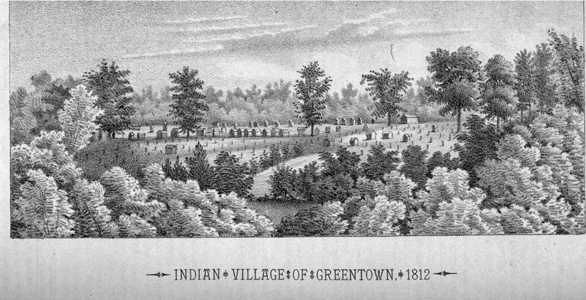
<
HISTORY OF ASHLAND COUNTY, OHIO - 35
territory west of the Ohio river and made his home among the Delawares, In response to the inquiry, Green gave Mr. Tyler; in the presence of his sons, the late Major Tyler and Benjamin, a full recital of his advent- tires, among other things stating that he had founded a village on the waters of Mohican, which the Indians in honor of himself called " Greentown ;" and that he possessed a great deal of influence over his Indian, brethren. In a few days Green and his companions returned to the wilds of the Black fork, and were never again seen by Mr. Tyler.
Mr, Benjamin Tyler thinks Green subsequently died among the Greentown Indians, and now rests in the old Indian cemetery.
Mr. Tyler is regarded as a truthful man, and the fact that Billy Montour, Thomas Jelloway, and Thomas Lyons were at the destruction of Wyoming, gives weight to the legend as detailed by him. We are of opinion his statement is reliable. We may conclude then that the founding of Greentown took place in the year 1783, and that it was so named in honor of Thomas Green, a Connecticut tory who joined the Indians.
CHAPTER XIII.
INDIAN TRAILS.
Ancient Indian Trails in Ashland County, from the period of the expeditions of Major Rogers and Colonel Crawford
AN examination of the maps and trails of the territory of Ohio throws much light on the expeditions of the Indians against the border settlements in Pennsylvania and Virginia. A knowledge of those trails enabled the early settlers to trace the flight of the Indians to their villages on the Muskingum, and at Sandusky, after committing depredations upon the persons and property of the pioneers. It was along these trails or paths that in subsequent years many of the first settlers in Ohio traveled to locate lands, and finally reached their new homes, in the absence of roads through the forests.
It is a subject of remark that the Indian trails, as well as th0se of the buffalo, have furnished the best location for canals and railroads, not only in Ohio, but west of the Mississippi, where those trails have been followed through the mountain gorges, and along the streams and rivers until the Pacific has been reached. Fremont and Carson, and in fact all the earlier emigrants to the Pacific slope, were well aware of the superior engineering qualities of the Indian and the buffalo, and did not hesitate to follow the paths marked out by them.
In f0rmer numbers we have alluded to certain expeditions, and paths of adventure through and across this county. It will, therefore, be interesting to notice the early Indian trails amid the forests and along the streams flowing through this county, and this, because along these trails many of the pioneers reached their future homes.
The first great trail was from fort DuQuesne to Sandusky. It commenced opposite the present site of Pittsburgh and ran a little north of west to the mouth of Big Beaver, twenty-five miles ; from thence to the junction of Sandy and Tuscarawas creeks at the south line of Stark county, ninety-one miles; from thence to the east line of Paint township in Wayne county, thence a little northwest through east Union township, along the south side of where Wooster now is, and crossed Killbuck three or four rods north of the bridge on the Ashland road, and continued along south of Little Kill- buck, crossing the Muddy fork of Mohican near the present site of Reedsburgh thence to Mohican Johnstown, where it crossed the Jerome fork of Mohican, fifty miles; * thence probably by the route of Rogers to Junandot or Wyandot Town, (Castalia) in the county, forty-six miles; thence to Fort Sandusky, on Sandusky bay, four miles; thence to Fremont on Sandusky river, twenty-four miles; the entire distance from Fort DuQuesne being two hundred and forty miles by said trail. t We are inclined to the opinion that this was a much traveled trail for perhaps a century before the forests of Ohio had been penetrated and taken possession of by the European.
It is also quite certain that from Mohican Johnstown - this trail branched off a little south of east passing through Plain township by the "Long Meadow," or perhaps a little south, by Mohican John's Lake in Clinton township, in Wayne county, thence across Killbuck some twelve miles south of Wooster, where Rogers crossed that stream, and where we feel quite certain that Colonel Craw ford also crossed, and encamped a short distance north of what is now known as Odel's lake, then known as Mohican John's Lake, on his expedition to the Moravian settlement on Sandusky creek, in Crawford county.
From Mohican Johnstown there was also a trail, running southwest, to the Delaware village of Greentown, by or near the former site of Goudy's old mill, to the Quaker springs, in Vermillion township; thence, continuing southwest, over Honey creek, to the west part of Green township, to a point about three miles west of Perrysville. This trail was, subsequently, known as the old Portage road, ++ and was traveled by many of the pioneers to their new homes in Green township. The trail continued thence, in the direction of the present site of Lucas, to near Mansfield.
From Mohican Johnstown there was also another trail, running up the east side of the Jerome fork, much traveled by the Mohegans, in their hunting excursions on the Black river; and, in the north part of this county, to the junction of the Catotaway, in the eastern part
* We are indebted to Hon. H. Byers, of Wooster, for the course of the trail through Wayne county. Having access to the papers of Joseph H. Larwill, now deceased, he finds a map, which was made at the land office at Cincinnati at a very early day for Mr. Larwill's own use, and is no doubt positively accurate, as it was made from the field notes of the surveyors of whom he was-one.
+ See Taylor's History of Ohio, page 163.
++ The late Judge Peter Kinney helped survey and open this path from New Lisbon, Wooster, Jerome's place, Greentown, Fredericktown, and Clinton, Knox county, Ohio, as early as 1810. They followed the trail.
36 - HISTORY OF ASHLAND COUNTY, OHIO,
of Montgomery township, where it crossed, and passed near the residence of Moses Latta and Burkholder's mill, and thence up the creek, past the old Gierhart farm. Here resided a proud old Indian hunter, named Catotawa, after whom the stream was undoubtedly named. Some of the pioneers of Montgomery remember him well.
At, or near, the former residence of the late Mr. Samuel Burns there was another path, or trail, which ran past the residence of Mr. Newell, continuing up the creek, to the former residence of Daniel Carter, sr., a few hundred yards north of the bridge on the Harrisburgh road; thence, up the stream, to the present residence of Mr. David Sloan; thence to Mr, Leo Wertman's; thence to near the old Cunningham residence; and from thence to the Vermillion lake, and down the Vermillion river, in the direction of the Huron, into Richland county. This trail does not seem to have been traveled as much as that of the Catotaway.
There was also a trail passing down the east side of the Black fork from some point above Mifflin, to Green- town, where it met the trail from the direction of Lucas. From Greentown, as we are informed by colonel John Coulter, Mr. Alexander Rice and Mrs. Otho Simmons, who were among the earliest settlers in Green township, a trail passed down by the north side of the present site of Loudonville, nearly on the line of the Pittsburgh railroad, continuing down the valley through the lands of the Priests, in Holmes county, towards the Lake fork of the Mohican.*
Another trail kept down the south side of the Black fork from Greentown to the Walhonding proper, and then to the forks of the Muskingum; and probably was the path of the Moravians when they were enroute to their new home on Sandusky creek. These trails at the arrival of the early settlers were well marked, and were traveled by hunting parties from Upper Sandusky; and were evidently their great highways to the Muskingum, as well as Tullihas, Gnadenhutten, Shoenbrun, and Fort DuQuesne, and the Indian village on Killbuck, called Beaver.
Like the buffalo, the Indians always march single file; and their regular trails soon became so worn and distinct that they could easily be followed from point to point. When Rodgers passed over this country in 1761, he found the Indians in possession of horses, cows and hogs and it is tolerably certain that the Wyandots and Mahegans sometimes traveled with horses, and this circumstance also added to the distinctness of their trails. We are inclined to think that the elk and the buffalo had nearly disappeared from this region when Rodgers passed through to Pittsburgh, as they are rarely mentioned at that period.
* Another trail passed by the north shore of Odell's lake, thence a httle northwest till it reached Priest's prairie, thence in a northwest direction north of the gap, passing near the residence of Warring Wolf, thence across the north part of the lands of Hunter, Thomas McGuire, and near Carey's corners, thence north of George Guthrie's, thence to Mr. Boughman's old farm, thence to and up the Rocky fork. It was by this trail that Colonel Crawford marched to Sandusky in 1782.
CHAPTER XIV,
INDIAN CUSTOMS.
Manners, Customs, and Religion of Northern Ohio Indians.—Their Wigwams and Tents.—Making Sugar.—Planting Corn.
BEFORE entering upon the pioneer history of the county, we deem it appropriate to discuss, at some length, the customs, habits, social relations and religion of the Indians of northern Ohio. The red men of this part of the State displayed many traits worthy of admiration by the civilized races. When we consider that for ages the Indian tribes in this region had lived in ignorance of the laws and customs of the enlightened races of mankind, we are amazed at the purity of their morals, their comparative freedom from the vices of the white race, and their lofty conceptions of a Supreme Being, and of an existence after their departure, by death, from the hunting-grounds and forests of earth. The Indian of Ohio was proud, high-toned and chivalrous in a remarkable degree. The territories he inhabited, the streams along which he roamed, and the shores of the great lakes, were regarded as his property, given him by the Great Spirit as an inheritance for himself and his children forever. When he beheld the white race seizing and occupying his lands without adequate compensation, it is not a matter of surprise that he promptly resented such encroachments with all the means within his possession. Our fathers, for like reasons, repelled British authority in 1776, and demanded self-government and independence. We offered no terms to the Indian, but submission or death.
WIGWAMS AND TENTS.
For a description of the wigwams and tents of the northern Ohio Indians, we return to the narrative of James Smith. * The winter cabin was generally about fifteen or twenty feet long, and constructed of small logs laid upon each other, posts being driven into the ground at each end to keep them together, the posts being tied at the top with bark, and by this means the wall was raised about four feet high; and in the same manner, another wall was raised opposite, about twelve feet distant; they then drove forks into the ground in the middle of each end, and laid a strong pole from end to end on them, and from the walls to the pole they set up small poles for rafters, and on these tied small poles for laths, and covered them with lynn bark, which was peeled in wide strips, and carried off the rain, and kept the but quite dry. The bark was raised by the tomahawk near the top of the tree in strips five or six inches broad, and sometimes a piece would be thirty or forty feet in length. This was cut in suitable lengths to cover a cabin. At the ends of the walls split timber was set, so that the sides and ends were enclosed by timber, excepting a door at each end, over which a bear skin was suspended. At the top an open place was left for the escape of smoke. Bark was laid down as a floor, and bear skins spread for beds. From one end of the but to the other, in the winter season, in the center, the squaws made fires of
* Frost and Drake's History of Indian Wars and Captivities in the United States.
HISTORY OF ASHLAND COUNTY, OHIO - 37
dry, split wood. The holes between the logs were carefully closed with moss, gathered from old logs. This species of cabin was mostly used by the Wyandots, Delawares, Mingoes, and Mohegans, and is described by Smith and other captives, as being very comfortable during the severest winters. The Ottawas had a very useful and artistically constructed tent, which was made of flags plaited and stitched together in such manner as to turn rain or wind. Each mat was fifteen feet long, and about four feet wide. In order to erect this kind of tent, a number of long straight poles were driven into the ground so as to form a circle, the upper ends approaching together, so as to be tied. The mats were then spread on these poles, beginning at the bottom and extending up, leaving a small hole at the top to answer the place of a chimney. A fire of dry, split wood was made in the center, and bark and skins spread for beds, on which the Indians slept in a crooked posture, around the fire. For a door they lifted one end of the mat, and crept in, letting it fall down behind them. These tents were warm and dry, and generally quite free from smoke. Their fuel was generally split and prepared in the fall by_ the squaws, and kept under inverted birch canoes, where it was dry and free from rain. When the Ottawas traveled from one part of the forest to another, they took down their tents, and put them in large rolls, being very light ; and they were removed by the squaws. This tent resembled those now in use in our armies on the plains, in many respects; and was superior to the far-famed Sibley tent. In the construction of tents, therefore, the children of the forest have evinced wonderful skill, taking into account the materials out of which they were made.
MAKING SUGAR.
About the first of March the Indians commenced to tap sugar trees and make sugar. The sap was generally boiled in large brass or copper kettles which they purchased from the French or English in exchange for valuable furs. The manner of securing the water was very ingenious and successful. As elm bark will strip or run in the winter season, squaws cut down elm trees, and with a crooked stick, broad and sharp at the end, peeled the bark in wide strips, and made vessels in a curious manner that held two or three gallons each. Of these they made one or two hundred; and then cut a sloping notch in the sugar tree and stuck a tomahawk at the end of the notch and drove in a long chip or spile to carry the water to the bark vessel. They generally selected the larger trees for tapping, as the water was deemed stronger and produced the most sugar. They also made bark vessels for carrying water, which held about four gallons each. Having generally two or three, and sometimes six or seven, large kettles, they boiled the water very rapidly. When sap was produced faster than they could boil it away, they prepared vessels of bark that held about one hundred gallons each for the remaining water. 'Thus, they made sugar rapidly, and were always busy during the season. This sugar was generally mixed with bears' oil or fat until the fat was nearly as sweet as the sugar ; and into this the Indians dipped their roasted
venison. Sugar was sometimes kept in skins, but more frequently in bark vessels prepared for that purpose by the squaws. Bears' fat, when mixed with sugar, was put in vessels made of deer skins, which were pulled over the neck without ripping. The hair was then removed, and the skin gathered into small plaits round the neck and drawn together like a purse ; and in the center a pin was put, below which a string was tied ; and when the skin was wet it was blown up like a bladder, and let remain so until it was dry, when it appeared nearly in the form of a sugar loaf. One of these vessels would hold four or five gallons. In such vessels they carried bears' oil also.
PLANTING CORN.
When the season for planting corn arrived, the Indian women busied themselves in clearing a spot of rich soil for that purpose. Having prepared the ground with their rude hoes, they planted and cultivated it, and kept down the weeds with wonderful industry, until it had matured sufficiently for use. Their cornfields were mostly in the vicinity of the villages, and in favorable seasons yielded plentifully. The squaws took charge of the culture of corn exclusively. When Smith was among the Wyandots, the squaws requested him one day to take a hoe and help them. He did so, and says:
The squaws applauded me as a good hand at the business, but when I returned to the town, the old men, hearing of what I had clone, chided me, and said I was adopted in the place of a great man, and must not hoe corn like a squaw. They never had occasion to reprove me again, as I never was extremely fond of work.
It was the task of the Indian women to cultivate corn, pound and prepare the hominy, cut and carry wood, and, in fact, do all the drudgery, while the men pursued and captured the game, defended the wigwams and went to war. After the corn had ripened, it was parched, put in a rude wooden mortar, or on a flat stone, and pounded into a sort of meal, which was mixed with sugar, and sometimes a little bears' fat, and put in skin and bark vessels for future use; and is said to have been a palatable and nourishing food.
As corn (zea) was indigenous to this continent, and never seen in Europe until about the year 1495, it may be interesting to recite the Indian legend concerning its origin and use.* The legend runs thus:
In times past, a poor Indian was living, with his wife and children, in a beautiful part of the country. He was not only poor, but inexpert in procuring food for his family, and his children were all too young to give him assistance. Although poor, he was a man of kind and contented disposition. He was always thankful to the Great Spirit for everything he received. The same disposition was inherited by his eldest son, who had now arrived at the proper age to undertake the ceremony of the Ke-ig-nish im-o-win, or fast, to see what kind of a spirit would be his guide and guardian through life. Wunzh, for this was his name, had been an obedient boy from his infancy, and was of a pensive, thoughtful, and mild disposition, so that he was beloved by the whole family. As soon as the first indications of spring appeared, they built him the customary little lodge, at a retired spot, some dis-
* Indian Tales and Legends, by Henry R. Schoolcraft, volume I, page 122. Of course, this is a myth, but is nevertheless exceedingly interesting, and evinces some of the mental characteristics of the Indian. The boundaries between truth and fiction are but feebly defined among the aborigines of this continent. All their knowledge is made up of the misty recollections of tradition, and reads more hke a fairy tale than reality.
38 - HISTORY OF ASHLAND COUNTY, OHIO.
tance from their own, where he would not be disturbed during this solemn rite. In the meantime he prepared himself, and immediately went into it and commenced his fast. The first few days he amused himself in the mornings, by walking in the woods, and over the mountains, examining the early plants and flowers, and, in this way, prepared himself to enjoy his sleep; and, at the same time, stored his mind Mih pleasant ideas for his dreams. While he rambled through the woods, he felt a strong desire to know how the plants, herbs, and berries grew without aid from any man; and why it was, that some species were good to eat, and others possessed medicinal or poisonous juices. He recalled these thoughts to mind, after he became too languid to walk about, and had confined himself strictly to the lodge; he wished he could dream of something that would prove a benefit to his father and family, and to all others. "True!" he thought, "the Great Spirit made all things, and it is to him that we owe our lives. But could he not make it easier for us to get our food, than by hunting animals and taking fish? I must try to find out this in my visions."
On the third day he became weak and faint, and kept his bed. He fancied, while thus lying, that he saw a handsome young man coming down from the sky, and advancing toward him. He was richly and gaily dressed, having on a great many garments, of green and yellow colors, but differing in their deeper or lighter shades. He had a plume of waving feathers on his head, and all his motions were graceful.
" I am sent to you, my friend," said the celestial visitor, " by that Great Spirit who made all things in the sky and on the earth. He has seen and knows your motives in fasting. He sees that it is from a kind and benevolent wish to do good to your people and to procure a benefit for them, and that you do not seek for strength in war or the praise of warriors. I am sent to instruct you and show you how you can do your kindred good." He then told the young man to arise and prepare to wrestle with him, and it was only by this means that he could hope to succeed in his wishes. Wunzh knew he was weak from fastng, but he felt his courage rising in his heart, and immediately got up, determined to die rather than fail. He commenced the trial, and, after a protracted effort, was almost exhausted, when the beautiful stranger said: " My friend, it is enough for once; I will come again to try you;" and, smiling on him, he ascended in the air in the same direction from which he came. The next day the celestial visitor re-appeared at the same hour and renewed the trial. Wunzh felt that his strength was even less than the day before, but the courage of his mind seemed to increase in proportion as his body became weaker. Seeing this, the stranger again spoke to him in the same words he used before, adding, " To-morrow will be your last trial. Be strong, my friend, for this is the only way you can overcome me and obtain the boon you seek. On the third day he again appeared at the same time and renewed the struggle. 'the poor youth was very faint in body, but grew stronger in mind at every contest, and was determined to prevail or perish in the attempt. He exerted his utmost powers, and after the contest had been continued the usual time, the stranger ceased his efforts and declared himself conquered. For the first time he entered the lodge, and sitting down beside the youth, he began to dehver his instructions to him, telling him in what manner he should proceed to take advantage or his victory.
" You have won your desires of the Great Spirit," said the stranger. " You have wrestled manfully. To-morrow will be the seventh day of your fasting. Your father will give you food to strengthen you, and it is the last day of trial, you will prevail. I know this, and now tell you what you must do to benefit your family and your tribe. "Tomorrow," he repeated, " I shall meet you and wrestle with you for the last time; and, as soon as you have prevailed against me, you will strip off my garments and throw me down, clean the earth of roots and weeds, make it soft, and bury mein the spot. When you have done this, leave my body in the earth and do not disturb it, but come occasionally to visit the place to see whether I have come to life, and be careful never to let the grass or weeds grow on my grave. Once a month cover me with fresh earth. If you follow my instructions you will accomplish your object of doing good to your fellow creatures by teaching them the knowledge I now teach you." He then shook him by the hand and disappeared.
In the morning the youth's father came with some refreshments, saying, "My son, you have fasted long enough. If the Great Spirit will favor you, he will do it now. 1t is seven days since you have tasted food, and you must not sacrifice your life. The Master of life does not require that." "My father," replied the youth, "wait till the sun goes down. I have a particular reason for extending my fast to that hour." "Very well," said the old man, "I shall wait till the hour arrives, and you feel inchned to eat."
At the usual hour of the day the sky visitor returned, and the trial of strength was renewed. Although the youth had not availed himself of his father's offer of food, he felt that new strength had been given to him, and that exertion had renewed his strength and fortified his courage. He grasped his angelic antagonist with supernatural strength, threw him down, took from him his beautiful garments and plume, and finding him dead, immediately buried him on the spot, taking all the precautions he had been told of, and being very confident at the same time, that his friend would come to life. He then returned to his father's lodge and partook sparingly of the meal that had been prepared for him. But he never for a moment forgot the grave of his friend. He carefully visited it throughout the spring, and weeded out the grass, and kept the ground in a soft and phant state. Very soon he saw the tops of the green plumes coming through the grouUd ; and the more careful he was to obey his instructions in keeping the ground in order, the faster they grew. He was, however, careful to conceal the exploit from his father. Days and weeks had passed in this way. The summer was now drawing towards a close, when one day, after a long absence ih hunting, Wunzh invited his father to follow him to the quiet and lonesome spot of his former fast. The lodge had been removed, and the weeds kept from growing on the circle where it stood, but in its place stood a tall and graceful plant, with bright-colored silken hair, surmounted with nodding plumes and stately leaves, and golden clusters on each side. "It is my friend," shouted the lad ; "it is the friend of all mankind. It is Mondawmin. We need no longer rely on hunting alone ; for, as long as this gift is cherished and taken care of, -the ground itself will give us a living." He then pulled an ear. "See, my father, said he, "this is what I fasted for. The Great Spirit has hstened to my voice and sent us something new ; and henceforth our people will not alone depend upon the chase or upon the waters."
He then communicated to his father the instructions given him by the stranger. He told him that the broad husks must be torn away as he had pulled off the garments in his wrestling ; and having done this, directed him how the ear must be held before the fire till the outer skin became brown, while all the milk was retained in the grain. The whole family united in a feast on the newly-grown ears, expressing gratitude to the Merciful Spirit who gave it. So corn came into the world, and has ever since been preserved.
CHAPTER XV.
INDIAN CHARACTERISTICS
Indian Endurance.—Bear Hunting.— Indian Courtship and Marriage.— Matrimonial Fidelity.—Wampum.— Indian Doctors.
NOTHING is more astonishing in the Indian character than their powers of endurance. They have been known to travel one thousand miles through the trackless forests, over mountains, wide spreading prairies and across numberless streams and rivers, on the most meagre supply of food, sleeping upon the ground at night, with nothing to protect them but a blanket wrapped around their bodies, and a small fire at their feet. With a belt or girdle drawn around their bodies, a little sack or pouch of parched corn swung by their side, with rifle and ammunition, they pushed boldly along, and thus accomplished the most surprising journeys in an incredibly short period. That the reader maybe able to judge the accuracy of this statement, and fully comprehend Indian endurance as compared with a most striking example of fleetness among the white race, we will allow James Smith to relate an adventure with his Indian brother Tontileaugo, while a captive in 1756 among the Mohegans, Oita. was and Wyandots of northern Ohio. At that time the part of the tribe to which he was at-
HISTORY OF ASHLAND COUNTY, OHIO - 39
tached, was encamped on the Canesadooharie or Black river, not a great ways from the present site of Elyria, in Lorain county, Food was excessively scarce in that region, and Tontileaugo proposed to Smith to take a hunt on the head branches of that stream where they interlock with the Mohican and other branches of the Muskingum. Smith expressed a willingness to accompany him, knowing that he was an expert hunter. Having put up some sugar and bears' oil, and a little dried venison, they ascended the east branch of the Canesadooharie or Black river, about thirty-five miles and encamped. This was about the close of the winter months. They succeeded remarkably well in procuring game. While engaged in hunting, they discovered a stray horse, mare and colt that had been running in the woods all winter, and were in very good order. There was plenty of grass in that region all winter under the snow, and horses accustomed to feeding in the woods could work it out. These animals had become very timid and wild in consequence of not meeting with Indians or white people, Tontileaugo poposed to run them down. We will now permit Smith to relate, in his peculiar style, the balance of the enterprise. He says:
"Tontileaugo one night concluded that we must run them down. I told him I thought we could not accomplish it: He said he had run down hears, buffaloes and elks; and in the great plains, with only a small snow on the ground, he had run down a deer; and he thought that in one whole day he could tire or run down any four-footed animal except a wolf. I told him that though a deer was the swiftest animal to run a short distance, yet it would tire sooner than a horse. He said he would at all event; try the experiment. He had heard the Wyandots say that I could run well, and now he would see whether I could or not. I told him I never had run all day, and, of course, was not accustomed to that way of running. I never had run with the Wyandots more than seven or eight miles at a time. He said that was nothing, we must either catch these horses or run all day. In the morning early we left camp, and about sunrise we started after them, stripped naked excepting breech-clouts and moccasins. About ten o'clock I lost sight of both Tontileaugo and the horses, and did not see them again until about three o'clock in the afternoon. As the horses run all day in about three or four miles square, at length they passed where I was, and I fell in close after them. As I then had a long rest, I endeavored to keep ahead of Tontileaugo, and after some time I could hear him afler me calling chako, chako-anaugh, which signifies, pull away, or do your best. We pursued on, and, about an hour before sundown, we despaired of catching the horses, and returned to camp, where we had left our clothes. I reminded Tontileaugo of what I had told him; he replied he did not know what horses could do. They are wonderful strong to run; but withal we have made them very tired. Tontileaugo then concluded he would do as the Indians did with wild horses when out at war; which is, to shoot them through the neck under the mane, and above the bone, which will cause them to fall and lie until they can halter them, and then they recover again. This he attempted to do; but, as the mare was very wild, he could not get sufficiently near to shoot her in the proper place; however, he shot, the ball passed too low, and killed her. As the horse and colt stayed at this place, we caught the horse, and took him and the colt with us to camp."
We incline to the opinion that this remarkable race took place within the present limits of Sullivan township, in this county, and the west part of Homer township, in Medina county, on the east branch of Black river. If the reader will take a rule, and measure by townships, from a point a mile or two above Elyria, on Black rivers thirty-four or thirty-five miles, in a southwesterly direction, he will strike that branch in Sullivan and Homer townships. Concluding that the locality is accurately ascertained, IN will have to yield to Sullivan township the honor of the first horse-race within the limits of Ashland county.
BEAR HUNTING.
The Canesadooharie or Black river had been famous among the aborigines of northern Ohio, for the number and largeness of its bears, for more than half a century prior to the arrival of the pioneers. Some of the pioneers, yet surviving, of this county, visited the sources of Black river in search of bruin nearly fifty years ago, and relate many stirring adventures in search of him. It may not be known to the reader, that it was the habit of those animals, in the early part of winter, to select holes in large trees, or make a lair or nest in the alder- bush jungles, where they remained three or four months without eating or drinking! This may appear incredible, but it is declared to be a well-known fact among experienced pioneer hunters. In ascending large trees to reach the holes, the bark was scratched or torn by these animals in climbing, and the hunter had but little difficulty in ascertaining where they had lodged for the winter. The Indian hunters had observed all these signs, and rarely failed to rouse the bear from his comfortable home. Tontileaugo and Smith resorted to the following piece of strategy, which was the common mode of half a century after he left the Black river region, They felled a sapling or small tree against or near the hole; and it was 'the business of Smith to climb up and drive out the bear, while Tontileaugo stood ready with his gun and bow. They once found a bear about forty feet up in an elm. Tontileaugo got a long pole and some dry decayed wood, which he tied in bunches with bark, and climbed the tree, carrying with him the decayed wood, pole and fire. He then placed his rotton wood on the end of the pole, and setting it on fire, thrust it into the hole. He soon heard the bear snuff, and then descended rapidly to the ground, seized his gun, and waited until it came out; but it was then too late to see the sights of his gun, and setting it down by a tree, he instantly bent his bow, took an arrow, and shot the bear behind the shoulder, and it soon fell to the ground. Occasionally they resorted to the expedient of cutting down large trees with their tomahawks, to secure their game.
The attack of those animals within the jungles was more dangerous, but it was rare that they escaped the unerring aim of the Indian hunter. At the season of the year when those animals ascended large trees to their holes, the bark was scratched or torn by the bear in climbing, and the hunter had but little difficulty in ascertaining where his game had lodged for the winter. Those animals were generally very fat, and were prized very highly by the Indians for their oil and flesh, the mode of preparing which has heretofore been described. The skin was carefully stretched, cleansed and dried, and was used as a bed, and frequently as clothing in the winter by the Indians, Having secured a quantity of flesh and a number of skins, Tontileaugo constructed a canoe of elm bark, and having placed his meat and skins therein, embarked for the falls near the present site of Elyria, where he arrived in safety in one day, being thirty-four or thirty-five miles; while Smith, mounted on his cap-
40 - HISTORY OF ASHLAND COUNTY, OHIO,
tured horse, with a bear-skin saddle and bark stirrups, pr0ceeded by land to the falls, where his Wyandot and Ottawa friends were encamped. The Wyandots, Ottawas and Mingoes were generally quite successful in hunt ing bruin, and were well versed in his mode of seeking and securing winter quarters. They relished his flesh, and feasted upon his oil or fat; and a morsel of venison dipped in sweetened oil was regarded as a dainty dish by friend or stranger,
INDIAN MARRIAGES.
The Indian mode of courtship differed considerably from that of the European or white race. The chief or head of the family generally regulated the marriage relation, presenting the daughter to his choice of the young braves or hunters. When the daughter was allowed to select her own husband, it was not uncommon for her to press her suit with a young man, though the first address may have been by another young man. This was somewhat akin to the leap-year liberty of the white race, in which it is allowable for the young ladies to invite young gentlemen to call upon them, go pleasure trips or accompany them to suppers and refreshments, the young ladies footing the bills. Among the Wyandots and Delawares advances of that sort were not deemed immodest or improper; in fact, the young braves rather regarded such calls as a delicate piece of flattery, and encouraged their lady loves to continue their suit. The marriage relation seems to have been an agreement or contract between the parties to live with, and adhere to each other as long as domestic unity and fidelity prevailed between man and wife. As a general thing the Wyandots and Delawares kept their marriage vows with much faithfulness. The Ottawas were not regarded as being entirely free from immodesty; and very often, by their words and actions, put young men to the blush. The Ottawa men seem to have possessed more modesty than the women; yet many of the young squaws appeared really modest; genuine it must have been—for they had but little restraint by the laws of education and example. The Wyandots and Delawares prided themselves upon their virtue, hospitality and bravery; and we know of no well authenticated case where their female captives were insulted or misused. They always evinced the utmost modesty toward their unfortunate female captives. Among these tribes domestic infidelity was severely reprimanded and punished. Respect for parents and for age, fraternal affection, self-denial, and endurance under fatigue or suffering, were uniformly inculcated. These qualities have been applauded and acknowledged in their wigwams, in the mazes of the wilderness, and around the council fire.
WAMPUM.
Wampum is an Iroquois word, meaning a muscle; and a number of these muscles, strung together, is called a string of wampum ; which, when a fathom long, was a belt of wampum; but the word string is commonly used, whether it be long or short. These belts were esteemed very valuable by the Ohio Indians, and were very difficult to make; for, not having the proper tools, or instruments, the Indians spent much time in finishing them. When the Europeans commenced trading with the Indians, and ascertained the value attached to wampum, they soon contrived to cut the shells, and perforate the pieces, and then make strings of wampum, both neat and elegant. These they bartered with the Indians for their furs, peltry, and venison, and found the traffic quite profitable. The muscles were mostly found on the coast of Virginia and Maryland, and were valued according to their colors, which were brown, violet, and white. They were first sawed into square pieces, about a quarter of an inch in length, and an eighth in thickness, then ground round, or oval, upon a common grindstone. The hole was bored lengthwise, through each, large enough to admit a wire, or whip-cord, or any cord, to string them like beads; when they were ready for traffic. Four such strings, joined in breadth, fastened together with fine thread, made a belt of wampum ; being about three or four inches wide, and three feet long, containing, perhaps, four, eight, or twelve, fathoms. This was determined, by the importance of the subject which the belts were intended to explain, or confirm, or by the dignity of the person to whom they were delivered. Everything of moment transacted at solemn councils, either between the Indians, themselves, or with Europeans, was ratified, and made valid, by strings and belts of wampum. Black or brown wampum meant war or warning; red, with a hatchet in the middle, meant, also, to undertake war; and white meant peace. None but the war-belt showed any red color. By these belts, they also remembered the exact words of their treaties. This was a sort of Indian pnemonics; and, forty years afterward, the very words of a treaty could be repeated by the chiefs making it, *
INDIAN PHYSICIANS.
No part of Indian history is more interesting than their mode of treating diseases. In fact, they evinced a wonderful degree of skill in combating the distempers that assailed their race. In this respect they were, generally, quite as successful as the majority of the physicians of the white race. The favorite remedy for nearly all disorders, among the Delawares, Wyandots, Ottawas, Mohegans, and Mingoes, was the sweat-house. For this purpose, in every town, or near it, they built, of stakes or boards, covered with sods, a sweat-house; or dug a hole in the side of a hill; or drove down four stakes, and covered them with blankets or skins. Large flat, or round stones were heated red-hot, and placed in the center of the sweat-house; when the patient crept, naked, into the structure. Water was poured upon the hot stone, and, the sweat-house being closed, the patient was soon thrown into a profuse sweat; and, as soon as he found himself too hot, he crept out, and plunged into cold water, where he remained one or two minutes, and again returned to the oven, or sweat-house. This process was repeated about three times, when the patient smoked his pipe with composure, and, in most cases, the cure was complete.
* George Henry Loskiel, in his "American Missions," p. 26.
HISTORY OF ASHLAND COUNTY, OHIO - 41
They used herbs extensively in their rude practice. Old men, too feeble to hunt, became medicine men, and healed diseases to procure a comfortable living. One made the study of herbs a specialty, another examined and tested the virtues of every species of bark. They generally made a profound secret of their knowledge. The administration of their remedies was always accompanied by mysterious ceremonies, to operate upon the superstitious mind of the patient, and to make the effect appear supernatural,
They had remarkable success in healing wounds, old sores and ulcers. In fractures and dislocations of bones their surgery was as ingenious as original. If an Indian dislocated his foot or knee when hunting alone, he crept to a small tree, and tying one end of a strap to it, he fastened the other to the dislocated limb, and lying on his back, continued to pull until it was reduced.
In burns and chilblains, they used a decoction of beech hark and leaves, as a speedy and successful cure. In bleeding, a small, sharp pointed flint was fastened to a wooden handle, and placed upon the vein, and struck until the blood gushed out. Their medicine men extracted teeth very much as white surgeons do, with a sort of pincers. Rheumatism was treated by sweating and scarification. The bark of the white walnut, Pulverized when green, was often applied to the painful part until an eruption was produced, This remedy was ex_ tremely acrid, and produced a most pungent pain on the skin where it was applied. For a headache or a toothache, this bark was applied to the temples or the cheek. A strong decoction was also used in fresh wounds, as a styptic, and prevented swelling.
The bite of poisonous serpents was treated by the Indian doctors with wonderful success. They used the leaf of the rattlesnake root—polygala senega—as a most efficacious remedy. Indeed, they were so well convinced of the certainty 0f that antidote, that many Indians would suffer themselves to be bitten for a glass of whisky or brandy, A quantity of the leaves were chewed and immediately applied to the wound, and a small portion swallowed, producing intense thirst, which would relieve the effects of the bite, They also used the Virginia snake root—serpentinea virginiaenses—as a poultice for wounds of that description. A decoction of the buds of the white-ash—fraxemus carolina—taken inwardly, was believed to be a certain remedy for such wounds.
As tonics and stomachics, they used a decoction, of the bark and root of the thorny ash—aralia spinosa—the dogwood—cornus florida—the wintergreen—pyola umbellaa while the native jalap—convolvular jalappa-which grew in abundance, was used as a purgative. They had a knowledge of ginseng—panox quinque idiom -and it was regarded as a good tonic.
It is a subject of remark, that more than one hundred years before the whites discovered spring or fossil oil, now carbon oil, the Indians used it extensively as an ointment.
CHAPTER XVI.
INDIAN NAVIGATION AND THEOLOGY.
Indian Navigation.—Indian Theology and the Great Spirit.—Tecaughretanego, the Indian Philosopher.—His Remarkable Utterances Concerning the Great Spirit.
IN continuing a discussion of .the customs, manners and religion of the Indians of northern Ohio, it will be interesting to notice their modes of navigation. The precise period of the invention of canoes is a matter of conjecture. Canoes seem to have been abundant as a means of transportation and travel on the shores of the northern ,lakes on the appearance of the earliest Jesuit missionaries, and other adventurers in search of new discoveries. These vessels, wherever seen, bore a striking resemblance as to form, material and use. It is probable they were invented at a very remote period in Indian history, as a means of navigating the rivers and lakes of the north. The birch-bark canoe was a model of beauty and 'symmetry ; and so constructed, that it glided over the waves like a thing of life ; and journeys of sixty or seventy miles a day were often made down Lake Erie by a fleet of such vessels, with light sails made of flags, stitched after the manner of their tents. Their largest canoes were about four feet wide, three feet deep, and thirty-five feet long ; and could carry heavy loads. They were ingeniously constructed over a wooden frame, by stitching the bark so as to prevent leak and danger of sinking. They were often ornamented with rude paintings and colors, and a fleet of such vessels presented a strange spectacle. They were so light, that after a trip down the lake shore, they could be carried by four men many miles over the summit ridges, and again launched on the head-waters of the Ohio and Muskingum. When the Indians encamped any length of time they carried their canoes up the banks of the streams along which they hunted, and inverting them, converted them into dwelling houses, and making fires before them cooked their provisions, while they stored their baggage and meat and slept beneath these little houses which turned the rain and kept them dry. On the smaller streams and rivers these vessels were paddled by two or four men, and moved along with surprising speed. In the fall of the year the Indians buried their canoes, bottom up, on the banks of a stream, and uncovered them in the spring, when they were apparently uninjured by the frosts of winter, and ready for use again.
HOSPITALITY AND FIDELITY.
Smith relates that when encamped on the Conesadooharie or Black river, and Tontileaugo, his Indian brother, was out hunting, he was visited by a Wyandot, to whom he gave a shoulder of roasted venison that he had prepared for himself, which the Wyandot received gladly, telling him he was very hungry, and thanked him for his kindness, When Tontileaugo returned he related what he had done; he said it was very well, and added he supposed Smith had given him sugar and bears' oil to eat with it. Smith said he had not, as those articles were down in his canoe. Tontileaugo reprimanded him se-
42 - HISTORY OF ASHLAND COUNTY, OHIO
verely, by saying "he had just behaved like a Dutchman," and told him when strangers came to their camp he ought to give them the best they had. Smith admitting he had done wrong, Tontileaugo said "he must learn to behave like a warrior, and do great things, and never be found in such little actions." Indian hospitality was proverbial among the Ohio tribes; and while Williamson and his men were preparing to murder the poor Moravians at Gnadenhutten, they were engaged in cooking and getting breakfast for his volunteers. Could the contrast be greater? When white men or Indians were invited to their feasts, or to accept shelter or nourishment within their cabins, they were sure of protection, and a fair division of food. In fact, when the members of one tribe visited another, it was regarded as a suitable occasion for feasting and good cheer, until all their supplies of provisions had been consumed. In this respect they surpassed most of our own race. If a white man or an Indian refused to eat with them when invited, it was interpreted as a symptom of displeasure, or, that those refusing were angry and disliked those who had invited them to eat. No Indian was allowed to pass the camp of a hunter without being invited to eat and refresh himself, and to do otherwise was regarded a shame, and an evidence of excessive meanness, If all the food had been consumed prior to a request for it, the statement of that fact was always deemed an honorable apology. While it was deemed excusable among Indians to carry off the property of the "Long Knives," in war, no Indian was allowed to steal from another. This rule was adhered to with much severity until they learned to cheat, swear and steal, from their white neighbors.
An Indian never forgot an injury nor a benefit. When Simon Kenton had been captured, and thrice condemned by the Shawnees to be burned, Logan, whose kindred had been cruelly murdered by the Baker party on the Ohio river, approached him while the Indians were evincing their anger and menacing his life, and told him to fear not, for he would arrange the matter and save his life. He was always as humane as he was brave. The next morning he told Kenton he would send two young men to Upper Sandusky to speak a good word for him. When the young men returned Kenton was taken by them a prisoner to Upper Sandusky. Logan was then on the Scioto. Before leaving, Logan shook hands with Kenton, but gave no intimation of his fate. When he and his guards arrived at Upper Sandusky, the Indians, young and old, came out to welcome the warriors, and view the prisoner. He was again compelled to run the gauntlet. A grand council was immediately held. This was the fourth time his life was suspended in the balance. When it was organized, Peter Druyer, a Frenchman, then a captain in the British service, made his appearance in the council. He was British agent and interpreter in Indian affairs. It was to him Logan had sent Kenton for protection. He addressed the council in behalf of Kenton. He urged that Kenton be sent to Detroit, where he would be useful to the British in giving information of the movements of the whites in Ohio and Kentucky. He then offered them one hundred dollars in rum and tobacco. The Indians agreed, and Kenton was sent to Detroit, where he was detained and exchanged as a prisoner of war,* The character of Logan only serves to illustrate the acts of hundreds of others who interfered to save white men from impending death by torture at the stake. These instances of Indian fidelity are rarely excelled by the white race, When we consider how often the untutored children of the forest were deceived and wronged by bad white men, we do not marvel that their resentments were carried to the utmost severity. We would not apologize for, nor attempt to extenuate, any of their extreme cruelties, but must admit that, while their 'mode of torturing prisoners seemed unnecessarily cruel, it was their law of retaliation against implacable enemies. While we condemn the practice of burning helpless captives, what must we say concerning those Christian denominations that have felt it to be their duty to roast each other at the stake because of a difference of opinion on creeds, or assumed powers of enchantment, denominated witchcraft?
INDIAN THEOLOGY,
Had the aborigines of Ohio a theology ? We believe they had. James Smith relates a conversation he had with his elder Indian brother, Tecaughretanego, concerning the Great Spirit, and his dealings with the red men of the forest. After hunting two days without eating, Smith returned late in the evening, faint and weary. Tecaughretanego asked him what success. Smith told him not any. This Indian brother had prepared him a kind of soup from some fox and wildcat bones which lay about the camp, and which the ravens and buzzards had picked. He told him he was much refreshed. His Indian brother then handed him his pipe and pouch, and told him to take a smoke. After doing so, he informed Smith that he had something of importance to tell him, if he was now composed and ready to hear it. Being willing to hear him, Tecaughretanego proceeded thus:
He said the reason he deferred his speech, was because few men are in a right humor to hear good talk when they are extremely hungry, as they are generally fretful and discomposed, but as I appeared now to enjoy calmness and serenity of mind, he would now communicate the thoughts of his heart, and those things I knew to be true.
"Brother—as you have lived with the white people, you have not had the same advantage of knowing that the Great Being above feeds his people, and gives them their meat in due season, as we Indians have, who are frequently out of provisions, and yet are wonderfully supplied, and that so frequently that it is evidently the hand of the great Owaneeyo (God) that doeth this. Whereas, the white people have commonly large stocks of tame cattle, that they can kill when they please, and also their barns and cribs filled with grain, and therefore have not the same opportunity of seeing and knowing that they are supported by the ruler of heaven and earth.
"Brother—I know that you are now afraid that we will all perish with hunger, but you have no just reason to fear this.
" Brother—I have been young, but am now old; I have been frequently under the like circumstances that we now are, and that some time or other in almost every year of my life, yet I have hitherto been supported, and my wants supplied in time of need.
"Brother—Owaneeyo (God) sometimes suffers us to be in want, in order to teach us our dependence upon Him, and to let us know that we are to love and serve him; and likewise to know the worth of the favors we receive, and to make us more thankful.
" Brother—be assured that you will be supplied with food, and that just in the right time; but you must continue- diligent in the use of
* Howe's History of Ohio, page 311.
HISTORY OF ASHLAND COUNTY, OHIO - 43
means. Go to sleep, and rise early in the morning and go a hunting; be strong, and exert yourself like a man, and the Great Spirit will direct your way.''
These are sentiments worthy a philosopher; and Tecaughretanego but uttered the prevailing idea of the Wyandots and Delawares concerning the existence • of God and his overruling providence, At this time this great Indian was over sixty years of age, very much crippled, and unable to hunt ; and depended upon the goodness of the Great Spirit to feed him and his liltle son. Smith arose early the next morning and proceeded slowly about five miles and saw deer, but the crust of the snow made a great noise and they fled before he came in reach of them. Keeping up his courage he soon disc0vered buffalo tracks, and hastening into a small glade he killed a very large cow ; kindled a fire; roasted some of the meat; abated his hunger ; made haste and packed up all the meat he could carry and returned to the cabin of his Indian brother. When they were all refreshed, Tecaughretanego delivered a speech upon the necessity and pleasure of receiving the necessary supports of life with thankfulness, knowing that Owaneeyo (God) is the great giver. Such a speech from an Indian may be thought by those who are unacquainted with them altogether incredible. But when we reflect that the person who thus discoursed was no ordinary Indian, but in his sphere as great as S0crates among the educated Greeks, we are not surprised that he should deliver such a discourse upon patience, fortitude and faith.
* Frost and Drakes' Indian Captivities.
CHAPTER XVII.
TREATIES AND SURVEYS.
Brief Discussion of the Indian Policy of William Penn, and the United States.—Perfidy upon all Sides.
IN the year 1758, the French surrendered to the British authorities Fort DuQuesne, and, with it, fell French dominion in Ohio, Indiana, Illinois, and Michigan. In September, 1760, the French governor, Vaudrucil, surrendered the fort at Detroit to Major Robert Rogers, who left an English garrison to hold and defend it. The French never regained their possessions in Ohio, although they intrigued, through Pontiac and his savage allies, for their recovery,
In 1768, a treaty was held by Sir William Johnson, at Fort Stanwix, in central New York, in which the Indian title to the lands between the Alleghanies and the eastern boundaries of Ohio, was extinguished, and came under the jurisdiction of Pennsylvania. By this treaty, the colonists of Virginia were greatly gratified, by having their territory extended beyond the Ohio; although the Shawnees, Miamis, and many of the Wyandots, resisted the extension of the territorial dominion of Virginia, and it required many sanguinary campaigns to subdue their opposition. The Indians of Ohio continued to make incursions upon the frontiers of Pennsylvania and Virginia, often capturing many prisoners, and killing the helpless pioneer settlers. To soften their hostility, and obtain their good will, it was thought best to send agents among them, to hold talks and make presents.
In 1775, congress organized an administration of Indian affairs, and Captain James Wood proceeded to the territory of Ohio, by authority of the general assembly of Virginia, to invite a council at Fort Pitt, formerly Fort DuQuesne. In the meantime, Governor Hamilton, of Canada, used all his arts, through secret agents, to enlist the Indian tribes in the cause of Great Britain. Captain Wood found much difficulty in inducing the Ohio savages to meet him in council at Fort Pitt, but finally succeeded. Congress appointed Franklin, Henry, and Wilson, commissioners, to meet the Indians at Fort Pitt. The conference, in effect, accomplished nothing,
About that time Colonel George Morgan, a gentleman of undoubted courage, discretion and experience, was appointed Indian agent, and by his influence the hostility of the Ohio tribes was neutralized, and the horrors of impending invasion averted during the dreary years of the revolution. Morgan personally visited nearly all the hostile tribes, and finally brought about a conference at Fort Pitt, in October, in which nearly all the tribes were divided in their support of the British, and agreed to abstain from hostility against the border settlements. By presents, false representations, and intrigue in 1779, British influence had so far triumphed with all the western tribes except the Delawares and a few Wyandots, that it held the ascendency until 1783, when the tribes were humbled by the colonial forces, being abandoned by the British, who were compelled to retire before the victorious legions of the colonists. In 1784, a new treaty with the Six Nations took place at Fort Stanwix, at which those tribes were informed that Great Britain had yielded by treaty, to the United States, all claims to the country south and west of the great northern rivers and lakes, as far as the Mississippi, making no reservation in favor of any Indian nation, but leaving their tribes to seek for peace with the United States upon such terms as might be deemed reasonable and just. The chiefs of those powerful tribes expressed much surprise at the conduct of the. British authorities, claiming that they had risked all for their great father, the British king. There were many chiefs from the Wyandots, Delawares, Ottawas, Shawnees and other western tribes present at the conference. That treaty extinguished the claims of the Six Nations to all the lands west of the Ohio, and defined their future possessions in northern New York and Pennsylvania. In 1775, the treaty of Fort McIntosh was held, and the Wyandots, Delawares, Chippezewas and Ottawas were represented. By that treaty those tribes acknowledged themselves and all their tribes, to be under the protection of the United States. The boundary between those tribes was fixed by the commission. Citizens of the United States were prohibited from settling
44 - HISTORY OF ASHLAND COUNTY, OHIO.
on their lands; many persons having crossed from Pennsylvania into Ohio, were ordered to return and vacate their improvements.
While upon this topic, the reader will pardon a short digression upon the Indian policy of our fathers. The character of William Penn has been panegyrized alike by orator, poet, and painter. The picture has been sadly overdrawn, and William Penn placed in a false light. Let us examine his policy. It is asserted that he made a treaty with the Indians under a great elm at Shackamaxon, in which he made an ostentatious purchase of the lands of the aborigines. West, the painter, has drawn an imaginary picture of the scene, and the features of Penn, and the red men of the forest surrounding him. He is represented as purchasing their lands for a few yards of British broadcloth, a few beads and other tinsels. * Thus millions of acres of land were purchased for a few hundred dollars, and a homiletic snivel upon war and conquest delivered. History presents no authentic evidence of such a treaty ! It is simply a myth drawn from Quaker tradition, and never had any real existence. t That Penn had a talk with the Indians of Shackamaxon, now Philadelphia, and that he distributed a few presents in cloth, and discoursed on the wickedness of war, is doubtless true. All such sales to Penn, or any other party were void. But admitting they could enter into a contract. The consideration offered them for their lands was a fraud upon its face.
These criticisms may be regarded as too severe, by the friends of the old Quaker, but to show the superficial charity of the Penns in their Indian policy, we will add a few more facts of history. A son of William Penn, John, governor of Pennsylvania, in 1764, by proclamation, offered a premium for Indian captives and scalps. "For the capture of any male above ten years, one hundred and fifty dollars, or for his scalp, being killed, one hundred and thirty-four dollars; and for every female captured, one hundred and thirty dollars, or for the scalp of such female killed, fifty dollars.% Thus the fine theories of the good William were disregarded in the first generation of Penns. And because the Indians resented the loss of their lands, the venahty and cruelty of the whites, Governor Penn proposed to hunt them, like wolves, by offering a price for their scalps ! This was the occasion of the relentless Indian incursions, that desolated western Pennsylvania in later years.
When Lord Calvert purchased the right of occupation of the aborigines of St. Mary's, in Maryland, for a consideration which seems to have given general satisfaction, he carefully cultivated their friendship, and perfect amity prevailed. He gave the Indians in exchange for the liberty of occupying their land, axes, hoes and clothing, thereby endeavoring to introduce among them the first rudiments of civilization—the implements of agriculture.§ Yet, we have no \Vests painting fine pictures of him, and his new-made aboriginal friends.
* Chalmer's Annals, page 207.
t Clarkson's Biography of Pennsylvania.
+ + See Craigls History of Pittsburgh, page 97.
§ Bozman's " History of Maryland," volume II., page 569.
So, when Great Britain deserted her Indian allies in Ohio, Michigan, and the northwest, she did a cowardly thing. Her pretended ownership of their soil fell to the ground, and the United States were finally compelled to admit that the Indians were the owners of the soil, and obtained the same by conquest, treaty, and purchase, although the remuneration fell far below the just value of their lands. In 1786 the treaty at Fort Finney, at the junction of the Miami river with the Ohio, was held, and resulted in placing the Shawnees and other tribes under the protection of the United States, and admitting their sovereignty over all the land over which the Indians roamed.
Under her colonial charter, Virginia had claimed all the lands between the thirty-fourth and forty-fifth degrees of north latitude, which included all the territories of Ohio, Indiana, Illinois, Wisconsin, and Michigan. A counter-claim to a part of the territory northwest of the Ohio was set up by Connecticut. Other colonies complained that Virginia was about to take possession of nearly all the western territory, while the twelve remaining colonies had assisted in wresting it from the common enemy; and urged that those territories should be considered as common property, and sold as prescribed by Congress, for the common benefit, to be erected into free States for admission into the Union. In 1784, in order to settle all disputes concerning the territory west of Ohio, Virginia authorized her delegates in Congress to make a deed of cession to the United States of the territory in dispute, asking indemnity for her expenses of subduing the British posts in said territory. On the twenty-ninth of April, 1784, Congress accepted the cession, and the States subsequently endorsed the same, with a stipulation prohibiting slavery. In 1786 Connecticut also ceded to the United States her claims on the lands lying in northern Ohio, for the common benefit.
On the thirteenth of July, 1787, Congress passed the celebrated ordinance organizing the territory of the Ohio, now constituting five of the most prosperous States west of the Ohio river. The territory was organized under the ordinance; and General Arthur St. Clair was appointed governor of the Northwestern territory, on the fifth of October, 1787.* The intrusion of settlers had forced a public system of survey and sale of land upon the attention of Congress as early as May, 1785. An ordinance prescribing the mode of survey and sale of western lands was passed. It provided that a corps of surveyors—one from each State, and appointed by Congress—should be placed under the direction of Thomas Hutchins, geographer of the United States, and instructed to divide the territory into townships of six miles square, by lines running due north and south, and others crossing these at right angles, as far as practicable. The first line running north and south was to begin at the Ohio river, at a point due north from the western termination of the southern boundary of Pennsylvania; the first line running east and west was to begin at the same point and extend through the territory. The townships, whole or
* Taylor's history of Ohio.
HISTORY OF ASHLAND COUNTY, OHIO - 45
fractional, were to be numbered from south to north— the ranges of townships progressively westward. The townships were to be subsequently divided into thirty-six sections, each containing a mile square, or six hundred and forty acres, The survey has since been carried to half sections, quarter sections, and eighths, and in some cases to sixteenths, Jackson, Perry, Mohican and Lake townships are in the fifteenth range from the western boundary from Pennsylvania; and Hanover, Green, Vermillion, Montgomery and Orange in the sixteenth range, while Mifflin, Milton and Clearcreek are in the seventeenth range of townships. Ruggles, Troy and Sullivan were surveyed out 0f the Connecticut Western Reserve, and do not range with the sectional survey of this county. It was provided that where the survey of seven ranges of townships had been completed, plots should be returned to the board of the treasury, and the Secretary of War was to reserve, by lot, one-seventh part for the use of the late continental army, and so of every subsequent seven ranges, when surveyed and returned. Lots eight, eleven, twenty-six and twenty-nine, in each township, were reserved to the United States for future sale; lot sixteen, for the maintenance of public schools within the townships.
The Connecticut Western Reserve is situated in the northeast quarter of the State, between Lake Erie on the north, Pennsylvania east, the parallel of the forty-first degree of north latitude south, and Sandusky and Seneca counties on the west. It extends one hundred and twenty miles from east to west, and is about fifty miles wide, It contains about three million eight hundred thousand acres, It is surveyed into townships of five miles square each, About five hundred thousand acres of the west end was set apart by the State of Connecticut to sufferers by fire during the revolution. These lands were donated in 1792. The townships being five-. miles square were subdivided into four quarters, and these into lots of from fifty to five hundred acres each to suit the purchaser, Hanover, Green, Mifflin and Milton townships were surveyed by James Hedges, deputy United States surveyor, and a citizen of Virginia, in 1807. Vermillion, Montgomery, Lake, Mohican and Perry were surveyed by Jonathan Cox, deputy surveyor, under Mansfield Ludlow in 1807, Clearcreek, Orange and Jackson townships were surveyed by Mansfield Ludlow in 1807. The three northern townships, Ruggles, Troy and Sullivan, being part of the Western Reserve and "gore," were surveyed about the time that territory was divided into townships. At the period when these surveys took place, the territory now constituting the limits of Ashland county had not a single pioneer within it; but was used as a free hunting ground by the Wyandols, Ottawas, Delawares, Mohegans and Mingoes. The first land office for the entry and purchase of lands was established at Canton, Ohio, soon after the survey was completed; and a majority of the lands of this county were entered at that office. Subsequently an office was established at Wooster, Ohi0, where the pioneers purchased the remaining lands of the county, subject to entry,
CHAPTER XVIII.
THE SURVEY.—AN ADVENTURE.
Notes of the Surveyors.—A Description of the Timber, the Quality of the Lands, the Size and Direction of Streams.—The Indian Villages. —An Adventure with Two old Chiefs, Pipe and Armstrong.
HAVING access to the field-notes and observations of the surveyors, by whom the sectional subdivisions of this county were made (now in possession of the county surveyor), we find many topics noted, worthy of preservation, and of deep interest to the people who now occupy the lands alluded to by the surveyors. The names of the parties accompanying these surveys, are not mentioned in the field-notes. The surveyors seem to have carried tents, and encamped during the nights and rainy days, doing their own cooking, after the manner of hunters and soldiers. Their provisions were purchased, generally, at the village of Clinton, Knox county, and carried through the forests on pack-horses, requiring two or three days to perform the journey.
The distance traveled, in making the surveys, varied from six to eighteen miles, depending much on the nature of the forests and the marshes, per day. In passing, the sectional lines were blazed, and the corners marked by trees or posts ; and the character of the soil, and the kind of timber, carefully noted, as well as the number, size, and direction, of the brooks, creeks, and other streams, to enable the purchaser of the lands to ascertain the value of the soil, of which he was to become possessed.
Range fifteen, composed of Lake, Mohican, Perry, and Jackson townships, was first run. The lands along the east range line, in Lake, Mohican, and the south part of Perry, are described as generally level, and the timber much burnt by fire, with barrens, and a few scattering trees. This was the work of the Indians, in pursuit of game. In Lake township, the range line, or eastern boundary, was surveyed by William Ludlow, in 1806; and the sectional subdivisions were made in March and April, 1807, by Jonathan Cox, deputy United States surveyors. In the sectional survey, we find that Lake township had been pretty much all burned over, and that the principal timber was small white oak, burr oak, hickory, dogwood, and hazel. The surveyors continued their work on Sundays, the same as other days.
The major part of Mohican township was burnt over, and the timber much destroyed. In the swampy marshes, alder-bushes and willows were the principal timber. The timber on the uplands was generally white oak, hickory, dogwood and ash, much injured by fire. Indian trails leading down the Mohican, and out of the northwest, northeast, and southwest parts of the township, are often mentioned by the surveyors. The Indian village of "Mohican Johnstown," on section eighteen, containing "about fifteen" persons, is noted. This was probably about one-fourth of the actual population, the balance being engaged in hunting. The Indian reservation in Mohican township consisted of four sections (seven, eight, seventeen and eighteen), of which they retained the title until about the year 1818, when the general
46 - HISTORY OF ASHLAND COUNTY, OHIO
government purchased their lands, and subdivided them into quarter sections, and they were sold at the Wooster land office to purchasers. The sectional subdivision of this township was surveyed by Jonathan Cox, and completed on the tenth of December, 1806, shortly after the range line had been run.
The survey of Perry township was commenced on the second of October, and completed on Sunday, November 15, 1806, by Jonathan Cox. In running the south boundary, going west, at the southwest corner of the thirty-sixth section, they crossed a well worn and much used Indian trail, known as the Wyandot trail, extending from Sandusky to Fort Pitt or DuQuesne. It passed through section thirty-six in a northeasterly direction, over the Muddy fork of Mohican John's creek, which was fifty-eight links wide, and ran southeast. The land here is described as level, and grown up with brush eight feet high, with but few trees of common size, having been often burned over by the Indians. The whole -south line was pretty much burned over, leaving much brush and undergrowth, and but few large trees. On the sixth mile they came upon an Indian trail or path, much used, bearing northwest; and then to a creek (Jerome fork of Mohican John's creek), seventy-five links wide, running southeast. In running the east boundary, the land is described as being mostly level; the timber, white oak, hickory, sugar, maple, and some ash. The land in this township varies from rich to second and third rate, and is gently rolling, with oak, hickory, sugar, walnut and cherry timber.*
Jackson township was surveyed by Maxfield Ludlow, who commenced on the south boundary line on Saturday, October 4, 1806. In running the south line, going west, he came to the Muddy fork of Mohican John's creek, sixty links wide, and running southeast and heads north west. The land, second rate; from the creek, gentle ascents and descents; timber, beech, oak, sugar, hickory, and undergrowth throughout the ,whole line. In subdividing into sections, he commenced on the first mile north of the southeast corner of the township, on the east boundary. On the second tier of sections, south side of the township, Mr. Ludlow struck a blazed road t which starts from the center of the fourth township and range in the United States military lands, and leads to the mouth of the Kayahoga (Cuyahoga). The fifty-seventh mile-tree bears northeast and southwest. This road subsequently became the Cleveland road, and passing through the north corner of Perry township, enters Montgomery at the late residence of James Boots, passing by the farm of Aaron Markley, through Ashland, and south-
* About the year 1808, Joseph Larwill, of what is now Wooster, surveyed the sectional subdivisions of Perry township. While thus engaged, "Captain Pipe" and several of his warriors came upon the surveying party and ordered them to desist, saying : " You go tick- tuck, tick-tuck, all day. Me cut your legs off, then how you go tick- tuck, tick-tuck ?" In the meantime, his warriors seized and ran away with the chain, and thus put a stop, for a while, to the work.—Letter to the author by Hon. A. H. Byers, of Wooster, Ohio.
t This was the hne of the old Cuyahoga road, which had been surveyed and blazed from Frankhnton, in Franklin county, Ohio, to the mouth of the Cuyahoga river, some time previous to the range and section surveys.
west to Mansfield. It passed between sections nineteen and twenty and eight and nine in Jackson township, where it intersected the Connecticut Western Reserve line. The land of this township is described as good, and the timber is especially praised by Mr. Ludlow.
RANGE SIXTEEN
is composed of Hanover, Green, Vermillion, Montgomery and Orange townships. Hanover was surveyed by James Hedges, who commenced March 15th, and ended March 25, 1807. The east boundary had much burnt woods. On the fifth mile going south, came to an old Indian boundary line, being perhaps the north line of the Jelloway reservation, in Knox county. The line runs southwest across the township, and passes out nearly in the middle of section thirty-one. In subdividing the township, between sections one and two, he touches Armstrong's creek, one hundred and fifty links wide, running southwest. This creek is so named from Captain Armstrong, an Indian chief who resided at the village of 'Greentown, some eight miles higher up on the stream. It is also described by other surveyors as the Muddy or Black fork of Mohican John's creek, but more properly known as the Black fork or principal head of the Walhonding or White-woman's river. The junction of the Clear fork with the Black fork is mentioned, the width being one hundred and forty links. In running the south boundary, going west, came to an old Indian path or trail leading north and south—perhaps to the Jelloway settlement on the Walhonding. The land of Hanover is described as being rugged and poor, with stunted timber, much burnt on the northeast part of the township.
Green township was also surveyed by James Hedges in April, 1807. In running the south and east boundary of this township Mr. Hedges seems to have been much embarrassed over the variations in his compass. In order to test the accuracy of the survey the lines were re-surveyed. He could not determine the cause of the variation. Along the south line, land rolling and timber much burnt, underbrush plenty. On the west boundary, going north, came to Mohican John's creek (Clear fork) one hundred and fifty links wide—runs east from northwest. On the fourth mile to Muddy fork of Mohican John's creek one hundred and fifty links wide, runs southeast. Crossed over and came to an Indian village in the line. This was the village of Greentown or Armstrong's village, located on section eighteen. Here a section post was stuck in a cornfield. The number of Indian families residing at this village is not given, but must have been fifty or sixty. The village was situated on a rolling slope of land extending down to a bend in the Black fork ; and the spot upon which the graveyard and village were placed must have contained from four to five acres. These Indians offered no resistance to the surveyors. Indian trails, much used, were found leading northwest and down th stream. The land of Green township, down the valley, is regarded as prime, though wet and marshy. 'The timber in the valley and on the hills adjacent was much burnt, and the undergrowth thick and difficult to pass. Tim-
HISTORY OF ASHLAND COUNTY, OHIO - 47
ber—white oak, burr oak, dogwood and ash. Balance of the township rolling land, second rate,
Vermillion township was surveyed by Jonathan Cox, in April, 1807. In running the south boundary, which was done in October, 1806, James Hedges, by whom it was done, became greatly confused over the variations of the length of the line. He re-surveyed it three times and observes : " I am at a loss to know what cause to attribute the increased length of the south boundary line of said township twenty-one, range sixteen. The chaining on said boundary must be imperfect, or the variation must operate very partial in running south on west line of said town." On the third survey he says*: " I find the chaining correct. I am now much perplexed to know the cause of my westing or inclining south. The variation must operate very partial, or my compass must have been unluckily altered." He then re-surveyed the west boundary, and coming to the southwest corner of said town observes: " Here I experience troubles of a new kind, having already spent two days and a half waiting on an Indian chief* who appeared hostile to our business ; also laboring under the difficulty of a hand being absent thirteen days on a tour for provisions, in the meantime having lived eight days upon boiled and parched c0rn, I now find my camp robbed of some necessary articles, and two hands that I left to keep the same revolted and run away; these difficulties increased my range and town lines not being finished, expecting shortly other surveyors after me to subdivide; all conspire to make me unhappy. No alternative remains but to proceed to Owl creek and get hands and provisions. This being the twentieth day of October, 1806." This suspended operations until April, 1807, when Jonathan Cox proceeded to subdivide the township into sections. In running along the east boundary Mr. Cox came upon Indian trails much traveled, running northeast and opposite. These trails doubtless passed over to Green- town, along what is now known as the old Portage road, and led from Mohican Johnstown. About one mile south of the northeast corner he found a path much aveled leading n0rthwest and opposite.t Along the west boundary in the s0uthwest corner of the township were also much traveled Indian paths. The land of the township is described as mostly of gentle ascents and descents ; timber—oak, hickory, sugar, maple, ash, some walnut, chestnut and dogwood.
The range boundaries of Montgomery township were surveyed by Maxfield Ludlow, in October, 1806. In running the south boundary, going west, seventeen chains and twenty links from the third mile stake, he came to an Indian path or trail running southeast and northwest. This path is described as a well worn road or trail. This is the well known path 0f the Wyandots, which was followed by Major Robert Rogers, in 1761, in his route to the forks of the Muskingum, on his return op Pittsburgh, or Fort DuQuesne; as well as by General
* Probably Captain Thomas Armstrong of the Greentown village on the Black fork:
+ This was the old Huron or Wyandot trail leading across Vermilhon, Montgomery and Milton townships,
R. Beall in his expedition to Sandusky. This trail passed over the farm known as the late residence of John McCammon, thence across the Ryal farm, in Milton township, into Richland county, in a northwesterly direction, through Bloominggrove township. The east boundary of the township is noted as "flat, and marshy, with bottoms subject to overflow ;" the timber, elm, maple, sugar, swamp-oak and alder-bush. On the third mile going north, a plain, much traveled Indian path or trail, leading northwest, was seen. This path passed by the old Newell farm, thence to near the covered bridge on the Wooster road, where it divided, one branch leading up the Catotaway, and the other near the bridge on the Harrisburgh road, by the old residence of Daniel Carter, subsequently khown as the John Mason farm. The lands of Montgomery township on the east are described as level and rich; in the middle and west part of the township, as rolling and of good quality. The timber— ash, walnut, oak, hickory, cherry, sugar and maple, with considerable undergrowth, and a number of glades. The subdivision into sections was surveyed by Jonathan Cox, in November, 1806.
ANTIQUITIES.
On surveying the fifth tier of sections, Mr. Cox passed an ancient intrenchment or earthwork, containing about eight acres, on what is now known as the Gamble farm, on the north side of Ashland. This earthwork was circular in form, and had a gate-way looking to the southwest. The embankment walls were between three and four feet high, and perhaps eight 'feet wide at the base. A forest of timber—oak, hickory, sugar, maple and ash grew in and about this old fort, showing that it had not been used for centuries. By whom, and when, this work was thrown up, and for what purpose, will, perhaps, never be clearly ascertained. This curious old fort is yet remembered by the old settlers, though it is scarcely traceable, from the fact that it has been plowed over for more than fifty years. It was located on the plateau, just north of the residence of the late Henry Gamble. The Orange township boundary and sectional subdivisions were surveyed by Maxfield Ludlow in October 1806. In tracing the south boundary, going west, on the third mile, crossed an Indian trail bearing northwest and southeast ; and about half a mile west came to a creek sixty links in width, and running south. This was where James Wright formerly lived. The trail crossed the stream at the bridge near Jacob Young's house, and passed up the west side of the stream east of the residence of the late Patrick Murray, thence northwest near the shore of Vermillion lake. From the point where it struck the south line of Orange township, the trail passed by the Crouse school-house and cemetery over the old farm of Peter Thomas, to near the residence of Stephen Wolf, thence in a southeasterly direction across the Catotoway to Rowsburgh, and from thence to a point where it intersected the old trail leading from Mohican Johnstown to near the present site of Wooster; and was much traveled by the Wyandots and Ottawas in their excursions to the east part of the State, About the year 1816, that path was surveyed by Rev,
48 - HISTORY OF ASHLAND COUNTY, OHIO.
James Haney, of Savannah, who was a practical surveyor, to Rowsburgh, and from thence to Wooster, the late Samuel Urie, sr., being one of the viewers, and was opened as a road, and was the common highway of the early pioneers of Orange and Clearcreek townships.
The evidences of Indian occupation in many parts of Orange township, at that period, were numerous. The aborigines, it seems, were accustomed to assemble annually in the spring, in large numbers, upon the lands subsequently owned by Isaac Mason, Jacob Young, Jacob Heifner and Peter Biddinger, to make sugar and hunt, which custom they kept up until as late as 1815 or 1816. Mr. Biddinger, being a gun-smith, was often visited by them for repairs to injured or broken flintlocks.
The soil and timber of Orange township do not differ materially from Montgomery. The land is described as level, and of gentle ascents and descents.
RANGE SEVENTEEN.
After an absence of six days, Mr. Hedges returned from Owl creek, having secured hands and provisions to continue the range and subdivision lines. He commenced operations about the twenty-eighth of October, 1806, and concluded the sectional surveys about the second day of December. In running the south boundary of township twenty-two (Milton), he says the line passes over steep hills, amid "timber much burnt, with much underbrush, vines and briers;" timber, oak, chestnut, hickory and dogwood. On the second mile going west, "passed over a small wet prairie, and then crossed Black or Muddy fork. of Mohican Johnscreek," afterwards called by him, Armstrong's creek. He says : "'Phis stream promises fair for navigation, being a dead, still current, one hundred and forty links wide, runs southeast." The Black fork is now the boundary between Richland and Ashland counties in Mifflin township. Small flat boats, we believe, have been propelled as high as Perrysville in early times. Mr. Hedges then proceeded to verify the east boundary line of the township, running' north. This line was mostly over hilly land, the timber being oak, elm, beech and hickory, with much brush and grape-vines. He experienced some of the difficulties occurring on the south line of Vermillion in the third and fourth miles of this line. He says the "needle appeared not to work well, but the converging of the line to the one formerly run appeared to be nearly uniform throughout the six miles. The cause of my falling so far to the west when running south is to me not known." It may be that his compass had received some injury, but it seems to have been all right in the sectional subdivisions. Query was there some metallic influence arising from iron ore in the southwest corner of Vermillion township ? Mr. Hedges failed to comprehend the phenomena. Who will find valuable ores in that neighborhood ? The supposed rich ores are found in the lakes of Mifflin, and are bog ores. In running the sectional subdivisions the land in the cast part of the township is described as hilly, and the soil generally good. The western part was composed of level land, part bottoms and wet prairies. In section twenty- six he reaches Armstrong's creek, one hundred and eighty links wide. From this point, he calls the Black' fork, Armstrong's creek." In section twenty-three he finds a small lake, and a stream ten links wide flowing into the north and out of the south side of it. An old Indian path or trail enters the south part of the township, a few rods east of the Black fork, and continues northwest near the little lake, thence across the old Ruffner farm to the lands of Joseph Charles, continuing up the Black fork into the southwest part of Milton township, where it passed over into Butler township in Richland county, and probably united with the old Wyandot trail.
Milton is a fractional township, two miles of which, on the western side, were not annexed to this county when it was created. The sectional subdivisions were surveyed by James Hedges, who commenced the work November 4th, and ended November 20, 1806. Mr. Hedges failed to note many things of interest in his surveys, and, in this respect, fell far behind Mr. Ludlow and Mr. Cox. These surveyors not only noted carefully the kind and quality of timber, but also the direction and size of the streams, the Indian trails, villages, and other objects of curiosity. The south boundary of Milton is noted as uneven and hilly, land second rate, and timber composed of oak, beech, and hickory. The east boundary is noted as generally level, soil good; timber the same as on the south line, with sugar maple, dogwood, and an occasional wild cherry. The land of the township is described as of gentle ascents and descents, some places level; soil good for farming, and, generally, more or less clayey. It has an abundance of water, flowing from clear, pure, and never-ceasing springs. In the neighborhood of the Short farm is to be found one of the strongest springs in the county.
Clearcreek township was surveyed, and subdivided into sections, by Maxfield Ludlow, in the fall of 1807. It is, also, a fractional township, being only four miles wide, from east to west. In running the south boundary, the land is described as level, and second rate; timber, white oak, hickory, sugar, beech, and the usual undergrowth. In the subdivisions, the lands are regard ed as generally level and rich, and the timber of good quality. In some sections, he passes over beautiful farming land. In sections thirteen and twenty-four, he came to the bank of a lake, which bears northwest and southeast; turned, and made an offset south ; found the lake to be twenty-three chains south of the line, and twenty chains wide, from east to west; found an old Indian path, bearing northwest and southeast, on south side of said lake. This trail kept down the Vermillion river, which heads at the northwest corner of the lake, and runs northwest. In sections thirteen and fourteen, he again strikes the lake, which bears northwest three- quarters of a mile; crossed the head branch of Vermillion, twenty links wide; again crosses the Indian pat bearing northwest and southeast; again, between sections one and twelve, came upon another Indian path, leading northwest and southeast. This path must have branched at the lower end of the lake.
HISTORY OF ASHLAND COUNTY, OHIO - 49
In April, 1808, after completing the subdivisions, Mr. Ludlow proceeded to re-survey the Connecticut line, being the south boundary of the Western Reserve. He commenced at the east line of range fifteen, and ran to the west line of range seventeen. He commenced at. the eighty-third mile west, from the east range, or range one. This line had been surveyed prior to that time, by a Mr. Pease. On the eighty-fourth mile west, he reached the present boundary between Ashland and Wayne counties. About one-sixth of the ninety-first mile, going west, he struck an old Indian path or trail, north and south. This was in section two, on the north boundary line of Orange township. On the ninety-seventh mile, he came to a plain Indian path, bearing northwest and southeast. This was in section two, on the north boundary of Clearcreek, according to Ludlow; but Mr. Pease makes it in section four, in Orange township. On the ninety-eighth mile, he crossed Vermillion river, forty links wide, and came to west boundary of Ashland county on the ninety-ninth mile, going west.
CHAPTER XIX.
THE ERECTION OF FAIRFIELD COUNTY.
The County Created.—Its Great Extent.—Andrew Craig and Wife.— He is the First Scttler in Ashland County. —Alexander Finley and Wife.—Thomas Eagle and Family.—The Primitive Forests.
After the territory of this county had been surveyed into ranges, townships, and sections, in 1806-7, the territory now composing the counties of Fairfield, Licking, Knox, Richland, parts 0f Morrow and Ashland, was erected into one county, with the seat of justice at Lancaster. The inhabitants of Licking, Knox, and Richland counties, were then very few, and the settlements far apart. The region about Newark, Granville, Utica, Clinton, Bel'vide, and Mansfield, had but few residents, and the latter, perhaps, n0ne. The whole of Knox, the greater part of Licking, and the whole of Richland, was thickly covered with the original forest, and was the favorite hunting-ground of the Indian tribes of the Northwest. No white man had settled within the limits of this county at that period.
The great extent of Fairfield county rendered it very inconvenient for the pioneer settlers in the most remote portions of the county to visit the seat of justice, located at Lancaster. As early as 1806 the question of a division of the territory into smaller counties was agitated, and many petitions were sent the legislature, then in session at Chillicothe. The senator and representatives of Fairfield county favored the proposed division, and, in 1808, a bill passed both branches of the legislature, creating and fixing the boundaries of Licking, Knox, and Richland counties, The county of Richland, including most of the present limits of Ashland county, was left under the jurisdiction of Knox until the legislature should deem it proper to organize it into a separate county. In February, 1808, a commission, under a joint resolution of the legislature, fixed the seat of justice for Knox county at Mount Vernon, where the people of Richland county would have to attend court until that county should have a sufficient number of inhabitants to locate a seat of justice, and establish a court in her midst. Under this arrangement, in April, 1808, the entire population of Knox and Richland counties was requested to assemble at Mount Vernon and vote for a county commissioner, a sheriff, a coroner, township trustees, and other officers. We find that the greatest num ber of votes cast at that election was thirty-six; so that the aborigines of the forest were ten times more numerous than their white neighbors.
It is a mooted question as to who was the first white settler in Ashland county. Mr. Knapp is disposed to award the honor to Alexander Finley, who came from the present site of Mt. Vernon, and located at the present site of Tylertown, in Mohican township, April 17, 1809. He says: "At the time Mr. Finley settled in Mohican township, himself and family were the only white inhabitants within the limits of the territory that now constitutes the territory of Ashland." Mr. Norton, in his history of Knox county, awards the honor to one Andrew Craig. He gives the following description of Craig and wife, with the reasons for his location at Greentown in 1809:
“From our research into early statements, we are led to believe that Andrew Craig was the first white man who located within the present county limits He was, at a very early day, a sort of frontier character, fond of rough-and-tumble life, a stout and rugged man—bold and dare-devil in disposition—who took delight in hunting, wrestling and athletic sports, and "hail fellow well met" with the Indians then inhabiting the country. lie was from the bleak, broken, mountainous region of Virginia, and as hardy 'A pine knot as ever that country produced. He was in this country when Ohio was in its territorial condition, and when this wilderness region was declared to be in the county of Fairfield,* the sole denizen in this entire district, whose history is now written, tabernacled with a woman in a rough log hut, close by the little Indian field, about half a mile east of where Mt. Vernon now stands, and at the point where Center run empties into the Ko-kosing. There Andrew Craig lived when Mt. Vernon was laid out, in 1805—there he was upon the organization of Knox county, its oldest inhabitant—and there he continued until 1809. Such a harum-scarum fellow could not rest easy when white men got thick around him, so he left and went to the Indian village--Greentown--and from thence migrated farther out upon the frontier, preferring red men for neighbors."
While we are willing to award Mr. Finley all the honor to which he is entitled as a pioneer, we incline to the opinion that Mr. Craig was the first white man that settled within the present limits of Ashland county (excepting Baptiste Jerome and Thomas Green); and that Green- town, instead of Tylertown, furnished a home for the new adventurer. Greentown, at that period, contained from eighty to one hundred Indian families, many of whom resided in comfortable cabins. Mr. Heckewelder, in his account of the Indian nations ,+ says:
* Fairfield county was created by a proclamation of Governor Arthur St. Clair, December 9, 1800; and originally contained nearly all the territory of Licking, Knox, Morrow, Richland and Ashland counties,
+ See transactions of the historical and literary committee of the American Philosophical Society, volume one,--printed in Philadelphia, 1818, pages 132-3.