HISTORY OF AUGLAIZE COUNTY - 119
CHAPTER III
EARLY SETTLEMENT : THE PIONEER PERIOD.
Upon taking up a consideration of the days of early settlement and of the pioneer period of the region now comprised within the confines of Auglaize county the reader should keep in mind the fact set out in the preceding chapter that the Indians were still in possession of a large part of this region up to the early '30s, or until their cession of their lands here in 1831 and their departure for the West in the following year, these holdings having included the considerable reservation held by the Shawnees in the center of the county and that portion of the Logan reservation granted to the Senecas and surrounding Indian lake, which extended into the southeastern portion of the county in what is now Goshen township.
After the treaty of St. Marys in 1818 and the opening to settlement of the lands hereabout not otherwise reserved a few entries were made as early as in 1820, but there was no rush for land here as this then was still pretty generally regarded as Indian country. Mercer county and Allen county had been erected as civic organizations in 1820, but settlement throughout this entire region was sparse, the only particular activity along that line having been in the country surrounding the old St. Marys fort settlement, fourteen settlers having entered land in what is now St. Marys township, this county, in 1820, that township then having been included in Mercer county. In that same year one entry of land was made in what is now Noble township, John Wytand having taken up a small claim on the St. Marys river in section 22, about the center of the township, and in the next year (1821) Jonathan Taylor took up a claim just below the Wapakoneta reservation line in section 19 of Pusheta township, and Andrew Russell 119
120 - HISTORY OF AUGLAIZE COUNTY
entered claim to a small tract along the Auglaize adjoining the "Logan section" in Logan township.
Those who entered their claims in St. Marys township in 1820 were Thomas Scott, Charles Murray, Jonas Scott, John McCorkle, William A. Houston, David Mitchell, David Armstrong, Samuel Brunn, Robert Sleen, Leander Houston, James Botkin, John Hawthorn, Moses Larran and Asa Hinkle. Then, up to the time of the departure of the Indians, other landholding settlers entered St. Marys township, as follows: In 1822, Richard Barrington, Charles Smith and John Hawthorn; 1823, Joshua and Christian Benner; 1824, Jonathan Longworth; 1825, Pickett and Joseph Doute and Moses Sturgeon; 1826, John Inglebright ; 1827, James Major and Nancy Carter; 1828, Albert Opdyke ; 1829, Thomas Armstrong; 1830, William Botkin and John Helm, and in 1831, Elliott Cross, Charles Wilkie, and Charles L. Sims. Up to this latter year those besides Andrew Russell who had entered claims in Logan township were Dye Sunderland, James Crosier and Thomas Merryman; Goshen township, Daniel Black, adjoining the military land district; Wayne township, Joseph W. Bowdle, near the eastern edge of the township ; Pusheta township (in addition to Jonathan Taylor, mentioned above), Benjamin Spray and Solomon Waymire ; Washington township, Samuel N. McCullough, Thomas Chambers, Shadrach Montgomery and William Spray; Noble township (in addition to John Wytand, mentioned above), Charles Murray, Benjamin Tyrell, Lucas VanAusdale, Josiah Dungan, Jonas and John Wayland, William Sunderland, Israel and John Johns, Thomas Armstrong, R. V. and L. R. Brownell, William Jay and James Vanney, and in Salem township, Martin Overly, who took a claim in section 30, in the present Kossuth neighborhood.
When in 1828 Congress passed an act "to aid the state of Ohio in extending the Miami canal from Dayton to Lake Erie, and to grant a quantity of land to said state to aid in the construction of the canal authorized by law," etc., a strip of land equal in area to two and one-half miles in width on each side of the surveyed line of the canal from Dayton to
HISTORY OF AUGLAIZE COUNTY - 121
the Maumee river was granted to the state, subject to the disposal of the Legislature, for the purpose of constructing the canal, this strip of state land thus extending up through Jackson, German, St. Marys, Noble and Salem townships in what later came to be Auglaize county, the prospective settlers thereafter having a choice between these canal lands and the Congress lands outside the Indian reservations and the military tract. Upon the departure of the Indians in 1832 a laud office was established at Wapakoneta for the more convenient disposal of the reservation lands thus opened to entry and Robert J. Skinner was placed in charge of the same. These lands were quickly taken up, other public lands throughout this section gradually were disposed of as the settlers began to be attracted by the possibilities hereabout and in 1863 the land office was closed, all public lands within this district having been disposed of. Elsewhere, in the chapter relating to the townships of Auglaize county, will be found a list of all landowners in Auglaize county at the time of the county's erection in 1848, a list which perhaps properly may be regarded as a roster of "the fathers of Auglaize county," and to that the attention of the reader is directed in this connection.
A BRIEF REVIEW OF PIONEER CONDITIONS.
To the present generation, familiar with good roads, broad fields, well drained and tilled in accordance with the latest developments of agricultural science ; beautiful farm houses and well kept farm plants, compact and orderly cities and villages, with paved streets, waterworks, electric lights, telephones, radio outfits and all the conveniences, comforts and aids that man has devised to better his scheme of living; automobiles instead of the lumbering ox carts wallowing through roadways all but impassible half of the year, daily newspapers brought to the doorways of all who would read, railways and electric traction lines giving speedy and safe intercourse between the cities, and countless other "modern im-
122 - HISTORY OF AUGLAIZE COUNTY
provements," it may be difficult clearly to visualize the situation in which the pioneers of this region found themselves.
There is a good deal of contemporary evidence carried in the older chronicles regarding the insufferable difficulties and discomforts attending travel in the days when the wilderness held almost undisputed sway throughout this region. For instance, in the reminiscences of Judge Burnet, who presided over the court from Cincinnati to Detroit in Territorial days and who, when he and the lawyers then riding the circuit attended the general court at Detroit, usually proceeded by way of the Miami trail from Cincinnati, up through Dayton and Piqua and thence by Loramies, St. Marys, Ft. Amanda and Defiance, it is narrated that one time the circuit riders upon returning from Detroit, arrived at Ft. Amanda, the old Ottawa town at the northern edge of this county, and found that Blue Jacket had returned from Cincinnati with a large quantity of whisky and that the Indians were on a high frolic. Being afraid to remain in the village under the circumstances, the Judge and his party struck out over the swampy path for St. Marys. The swales were swarming with gnats and mosquitoes. Night overtook them when about half way. There was no moon and the almost impenetrable forests closed about them blackly. Leading their stumbling horses, they neither could keep the trail nor see to avoid quagmires and thus wandered about all night, reaching St. Marys at sunrise.
From General Harrison's official report of his campaign throughout this region during the days of the War of 1812, it is noted that "the best ground for roads is along the water courses. The country is almost a continuous swamp to the lakes. It is almost impossible to get through the Black Swamp. The road from Loramie to St. Marys and thence to Defiance is almost one continous swamp—knee deep to the pack horses and up to the hubs of the wagons. We are often unable to get the wagons along and many are left sticking in the mire and ravines, the wagoner being glad to get off with his horses alive." It is narrated that wagons often were one
HISTORY OF AUGLAIZE COUNTY - 123
month in making the passage of 105 miles from Cincinnati to Loramies, and two weeks in negotiating the remaining twelve miles up through what is now Auglaize county to St. Marys. In one instance, it is said, two teams with forage from Piqua to St. Marys, thirty miles, ate it all but six bushels while on the way. Such were the traffic conditions which faced the first comers here.
In the fall of 1812 Colonel Jennings' command cut a military road through the woods from St. Marys to Defiance and had 200 pack horses and 300 bullocks for transport service, but the almost continous rains and the ever prevalent quagmires prevented any very effective use of such a highway and the streams continued to be the chief medium of transport, save the sometimes impassible portage from Loramies to St. Marys, and the forts at the latter point and at the old Ottawa town (Ft. Amanda) were the centers of distribution to Ft. Wayne, Defiance and the lake.
The records of that time, as an instance of the terrible straits men were put to in order to get stuff through the country, narrate that in December of that year and thus early in the memorable campaign, two hundred barrels of flour for the army were started down the St. Marys from the post of that name for Defiance, by way of Ft. Wayne and the Maumee, the twenty dugouts and canoes being in charge of twenty men and three officers. It took the flotilla one week to reach Rockford (Shaves Crossing), less than twenty miles as the crow flies from St. Marys, though, according to one authority, little less than 100 miles by the winding river, which was full of fallen logs and obstructed by overhanging trees. The boats were caught in ice at Rockford, the weather having turned intensely cold, and one of the officers was sent back to St. Marys to report. He returned to the flour and offered the men extra pay if they would cut their way through the ice. They tried, made a mile in two days and gave up, leaving a squad to guard the flour. Just before Christmas a thaw enabled the party to proceed, but another freeze came on before they got to Ft. Wayne and the provisions were
124 - HISTORY OF AUGLAIZE COUNTY
transported on sledges the remaining distance to that fort, but no further effort was made to get them on to Defiance. When the settlers presently began coming up this way to make their homes in the wilderness conditions were the same as those set out in the authentic military reports and it thus easily may be imagined what the pioneers struggled through in getting here. A brave and plucky breed ; all honor to them!
FIRST PERMANENT WHITE SETTLER.
Not counting Francis Duchouquet, the French trader and long the interpreter for the Indians at Wapakoneta, who had come down from the north country and established a trading post not long after the Shawnees had taken up their abode at that point, Charles Murray, also a "squaw man," who in 1795 had bought out the trading outfit that James Girty, of infamous memory, had established some years before at the head of the portage of St. Marys, this post giving the early name of "Girty's Town" to the place, may perhaps be accounted the first permanent white settler in what is now Auglaize county. Murray continued to operate his trading post after the troublous times during the War of 1812 and was thus at St. Marys when in 1820 lands were opened to entry here, and was one of the first to enter land, he and William A. Houston and John W. McCorkle in that year having filed on lands now occupied by the St. Marys town site and in the summer of 1823 these three united in laying out and filing for record the original plat of the city of St. Marys. Professor Simkins' reminiscences have it that Murray's cabin and trading post were situated along the river at a point where the Lake Erie & Western railway crosses that stream and where the canal in time came to be cut through, just about the present heart of the city. The year of these entries (1820) was the year in which Mercer county was erected, St. Marys at that time having been in that county, and William A. Houston was a brother of John S. Houston, surveyor of that county
HISTORY OF AUGLAIZE COUNTY - 125
and one of the surveyors who helped run the lines through this region when it was being formally "laid out."
Concerning Murray, it is narrated in the reminiscences of Judge Edwin M. Phelps, who had so thorough a first-hand acquaintance with the pioneer history of this region, that "when he (Murray) came to St. Marys is not known with certainty, but it was before the War of 1812 and possibly soon after the treaty of Greenville. He was an Irishman and a trader. He bought all his goods at Detroit and brought them on pack horses. He died about 1831-2 and was buried in what is known as Murray's graveyard. When he was first known he had an Indian wife—a Shawnee—but as he prospered and the whites began to come in, he wanted a white one and found and married one at Piqua. This enraged the Shawnee and she threatened revenge. Finally she proposed that they should each take a rifle and go out in the woods a certain distance and each should be at liberty to fire at sight. She went out and he followed, but as soon as he got an opportunity to hide himself he sneaked back to his trading hut. She looked all through the woods for him, but finally concluded that he had run back. She went straight to his cabin and he was there. She drew up and he begged. She replied : 'Ugh! you cowardly pale face—mean man—I shoot you now.' and fired away and hit him in the shoulder. She kept him in constant alarm until he bought her off by paying her $300. She kept her contract with him and never afterward disturbed him.
"At the time of the treaty (1818) Murray was in jail at Troy, Ohio, awaiting his trial for the murder of one ThraiKES. Thraikes and his two sisters lived in the old blockhouse. Murray had some grudge against him and waylaid him between the two crossings of the Loramie, at a deep hollow ever since known as Thraikes run, and caused a hired man of his, one Myers, to shoot him. Murray was afterward tried at Troy, but was acquitted upon the ground that Myers was
simple minded and fired without his orders. He used to say, however, that 'nothing went well with him afterward,' "
126 - HISTORY OF AUGLAIZE COUNTY
Murray's two children, George and Eliza, by his white wife, are supposed to have been the first white children born within the confines of what is now Auglaize county.
At the time of the treaty of St. Marys (1818), according to Professor Williamson, there were not more than six or eight families residing at that point and they occupied the blockhouse. These blockhouses which had been erected under direction of General Harrison by Colonel Barbee as immediate outposts of the fort erected at St. Marys in the fall of 1812, were very serviceable adjuncts to the fort, each having been surrounded by a stout stockade ten feet in height. An excellent spring provided water for the occupants. One of these blockhouses, it is narrated, stood on the ground now occupied by the city building at St. Marys and the other on the lot later occupied as the residence of Christian Buehler. The fort proper—Ft. Barbee, so named for the colonel under whose command it was erected—stood at the point now occupied by the Lutheran cemetery on the southeastern edge of the town and on the opposite side of the river was established a burying ground for the bodies of those of the soldiers who died during the time of the fort's occupancy. There also was another military burying ground just south of the present Lutheran cemetery. As Professor Simkins observes in his reminiscences, "near such trading posts and forts, questionable characters and half-breeds usually had a settlement known as ' Squaw Town.' There was such a place on the south side of the Reservoir branch just south of St. Marys."
THE MEMORABLE TREATY OF ST. MARYS.
The conclusion of that notable series of treaties between the Indians and commissioners of the Government at St. Marys in the fall of 1818 and which was the last great assemblage of Indian nations in Ohio, was an event of great historical importance throughout the then rapidly developing new states of Ohio and Indiana and the then territories of Michigan and Illinois. The meeting attendant on the negotiation
HISTORY OF AUGLAIZE COUNTY - 127
of these treaties and beginning on September 17, 1818, was the occasion of the foregathering of the chief men, sachems, chiefs and warriors of the Wyandot, Seneca, Shawnee, Ottawa, Delaware, Pottawattomie, Wea and Chippewa nations and was attended by many stirring events, the grave formalism of governmental procedure and the showy maneuvers of attendant troops of cavalry and infantry broken by the constant exhibitions of barbaric prowess on the part of the assembled Indian "braves," all providing a picture that ' must have indelibly impressed itself upon the minds and imaginations of all present. Although the real business of the meeting did not commence until the 20th of September, it is narrated that the chiefs and warriors of western and northwestern Ohio, in addition to those of Indiana, Illinois and of Michigan began to assemble in the latter part of August and by the 12th of September representatives of all the Indian nations in interest were encamped alongside the west bank of the St. Marys river, this encampment extending from old Ft, St. Marys, south of the present city, to the point now occupied by the old cemetery north of the city. The boarding houses, "pitches" of the traders and barracks for the assembled soldiers were erected at intermediate points between the two forts, extending from what is now Spring street south to beyond the Lutheran cemetery or to the bank of the river.
The United States commissioners were accompanied by the Governors of Ohio, Indiana and Michigan and were escorted by a troop of Kentucky cavalry. The public dignitaries and their secretaries, agents and officers were entertained at the boarding house of old Charlie Murray, above referred to, and the Edsalls, the house of the latter standing at about the point now occupied by the little brick house, formerly known as Pickett Douet's house, at the southern terminus of Main street. Judge Phelps's reminiscences have it that the Edsalls had been keeping a tavern at Greenville and having knowledge of the approaching treaty they came up from Greenville, along with David Armstrong, a son of Judge John Armstrong, and became established at St. Marys, whence
128 - HISTORY OF AUGLAIZE COUNTY
they some years later moved to Shanes Prairie and thence to Ft. Wayne. The Indians were encamped by tribes all round. The timber had been cut off by Harrison's men during the campaigns of 1812-13, but at the time of the treaty it was heavily overgrown with second growth and was rapidly reverting to its original wilderness state. The traveling traders were early on the ground with every conceivable variety of goods calculated to please the fancies of the Indians and adventurers of various hardened types also were present in numbers. During the month that the Indians were encamped in front of the forts many thousands of dollars worth of furs were given in exchange for articles displayed by the traders and, "in addition to these supplies, smugglers, located in retreats known only to the Indians, furnished them with 'firewater' that was the cause of many sanguinary contentions." By which latter clause it will be observed that the detestable offense of "bootlegging," so common in certain quarters in the present generation was perhaps quite as widely practiced, on occasion, a century and more ago throughout this region.
THE PROWESS OF THE GREAT KOLITSAH
Aside from the business connected with the negotiation of the treaties, for which they were assembled, the Indians spent their leisure hours in sports of various kinds. It is narrated that pony races were of daily occurrence and were the cause of many a fight around the camp fires at night when the wagers of the day were being settled, for the Indian ever has been an inveterate gambler—one of the vices he did not have to learn from the white brother. The game of football, an exceedingly popular athletic contest between the Indians, as has been set out in the previous chapter, also was one of the notable daily diversions of the assembled redskins and an old story of the meeting has it that "the officers and attendants never tired of witnessing the game." Then there were foot races and wrestling matches, both also popular sports with the Indians and eagerly watched by the whites present.
HISTORY OF AUGLAIZE COUNTY - 129
It is said that among the numerous Indians of unusual strength and agility none surpassed in prowess the great Kolitsah, who stood over six feet in stature and weighed more than two hundred pounds. Judge McCullough, describing Kolitsah in his reminiscences, said of him that "he was the most perfect speciman of physical manhood I have ever looked upon and I am confident he could out-jump or throw down any man in the Northwest." It is narrated that pending the negotiations a grand hopping match was arranged and that Kolitsah outdistanced all competitors by clearing fifty feet at two hops and a jump. A wrestling match was arranged between Tom Wilson, a then noted wrestler, and the Indian. Kolitsah bet his wrought silk belt against Judge McCullough's silk neckkerchief that he could throw Wilson.
"The contestants took holds," continues Judge McCullough's narrative, "and Kolitsah allowed his antagonist to exert his utmost before himself taking the aggressive. Wilson employed every art and energy, but all in vain. The Indian appeared planted and could not be moved. At length Kolitsah said, 'Now me,' and lifting Wilson, laid him upon the ground as he would a child. A second trial ended with the same result and Wilson gave up the contest. At the conclusion, Kolitsah returned the necktie to Judge McCullough, ring that it was too easily won. At another time, a Kentucky negro, noted for his great strength, was pitted against the Indian. The contest was sharp and decisive. The 'Now me' of the Indian was uttered sooner than it was in the contest with Wilson. The negro was thrown to the ground with great violence. Arising from the ground in a great passion, he was thrown a second time. Again arising from the ground he threatened to whip the Indian, but fighting was not permitted."
It also is narrated that in 1832 Kolitsah wrestled with John Norris, a soldier of the War of 1812 and a great braggart, at West Liberty, down in the neighboring county of Logan. The Indian appeared at the town on a challenge from Norris and on the day appointed a large crowd was present
(8)
130 - HISTORY OF AUGLAIZE COUNTY
to witness the contest. A ring was formed and after a few preliminaries the contest began. It quickly became apparent that Norris had made a grave mistake, the contest, brief and decisive, hardly being worth the name. With his irresistible "grape-vine twist" Kolitsah snapped a leg of his antagonist as if it had been a pipestem. The friends of Norris interposed, crying "You have broken his leg, Kolitsah!" The imperturbable Indian only replied, "Leg must be rotten," and left Norris to be borne from the field.
During the time of the treaty negotiations at St. Marys the representatives of the several Indian nations present were well provided with provisions. Droves of cattle and hogs, corn meal, salt and sugar were furnished by the general Government and upon these articles and the game brought in by the Indian hunters they fared sumptuously every day.
SOME MEMORIES RELATING TO THE OLD FORTS.
Auglaize county is rich in recollections and traditions concerning the forts that were a stanch defense hereabout in the days of Indian trouble. In the graphic picture, a reproduction of a faithful drawing of the period, presented elsewhere in this work, in the chapter relating to Wapakoneta, the county seat, and portraying the scene as it was in the days of Indian occupancy here, there is delineated very clearly a picture of old Ft. Auglaize, which was still standing 'long after the Quaker mission was established at that point. The site of this old fort thus is shown to have been just around the bend of the river as the stream enters the present city limits and from the presentation that has thus been preserved must have been a quite extensive and substantial structure, the stockade and blockhouses clearly having been designed to resist most any sort of an attack from mere bows and arrows. It is typical of the woodland forts of that period. Ft. Auglaize had its inception when the French trading post of Francis Duchouquet was established there at the Indian village at the point then considered the head of transport on the Auglaize
HISTORY OF AUGLAIZE COUNTY - 131
and the stockade was designed chiefly as a source of protection to the trader's stores against the possibility of a raid by a marauding band. During the time of the War of 1812 when Harrison's men were on duty throughout this region, particularly guarding the waterways, the old French stockade was materially strengthened and was used as a base of supplies.
It was during the time of the War of 1812 that Ft. Amanda was erected under General Harrison's orders on the commanding site of the old Ottawa village on the west bank of the Auglaize at about what now is the northern border of Auglaize county, in section 22 of Logan township. This fort was used as a supply depot and halting place for the troops operating throughout this region. The fort, or pallisade, was a substantial structure and effectually commanded the passage of the Auglaize.
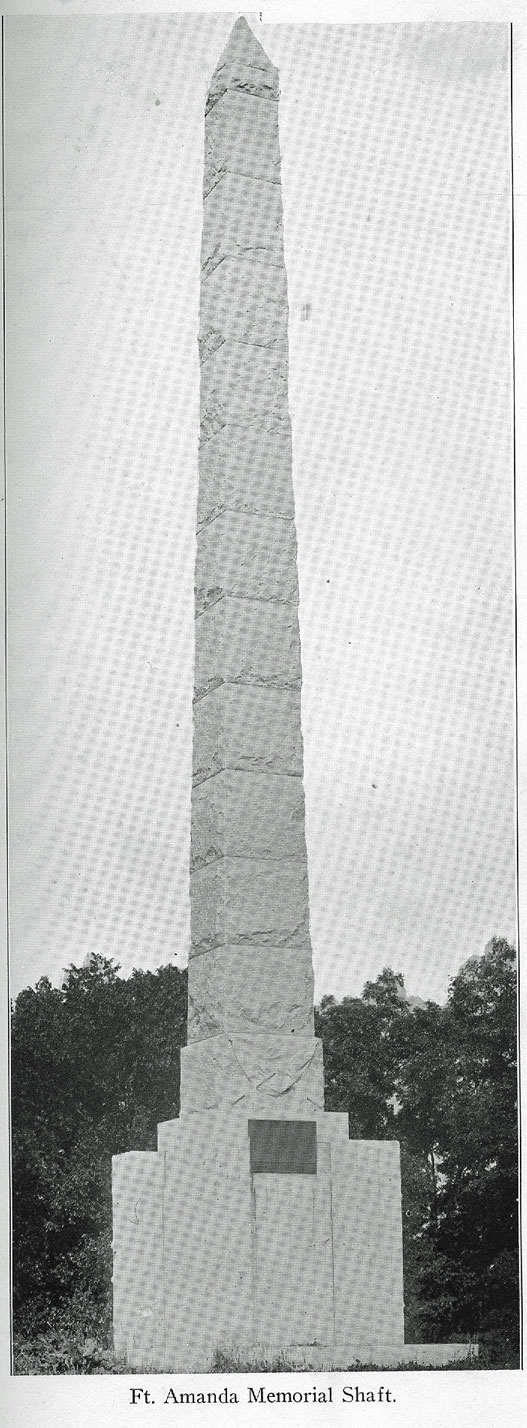
When General Harrison established his temporary headquarters at St. Marys in September, 1812, he ordered Col. Thomas Poague to clear and construct a wagon road through the wilderness from St. Marys to Defiance. This road was completed some time in October, when the regiment returned to a point on the west bank of the Auglaize and erected a fort, which, in honor of Colonel Poague's wife, whose name was Amanda, was given the name which thus has become historical, The soldiers who died there during the time of the military occupancy of this fort were buried in a plot on the north side of the ravine, just north of the fort, and in 1915 the state, acting in conjunction with the federal Government, through an appropriation previously granted, erected at that point the beautiful shaft, a picture of which is presented in this work. The bronze tablet on this monument declares the memorial shaft to have been "erected by a grateful people to the memory of the pioneer soldiers of Ohio and other states who fell in defense of their homes from Indian depredations and in the War of 1812." On this tablet it also is set out that the fort was "erected by order of General William H. Harrison in October, 1812, and became an important depository of army stores during the war."
132 - HISTORY OF AUGLAIZE COUNTY
Happily, from such contemporary descriptions as were available the memorialists were able to portray on the tablet a presentment of the fort as it stood in a partial clearing in the woods, this presentment, as will be noted by the picture of the tablet here presented, showing a stout stockade with two story blockhouses in each corner and a store house in the eater. It is said that the stockade inclosed a rectangular area of about an acre and one-half, the pickets being eleven feet in height off the ground and four feet in the ground. The blockhouse in the southeast corner was the largest and was used for officers' quarters. The second story of the central store house was used as a hospital and a well near the central building furnished an abundance of good water. It is said that there was stable room enough in the enclosure to accommodate 1,200 horses. The hospital soon was crowded with sick and wounded soldiers brought here by boat from the battle fields along the Maumee. The regimental surgeon, Dr. Jacob Lewis, thus had his hands full, for he also had to visit the sick at the fort at Wapakoneta (Ft. Auglaize) and the fort at St. Marys, and he was given valuable assistance by the army chaplains, Rev. Samuel Shannon and Rev. James Suggette, and the army paymaster, John Smith.
During the war Ft. Amanda served as a retreat for scouts, dispatch carriers and officers traveling from Cincinnati, Franklinton (Columbus) and Ft. McArthur to the armies in the north. During the winter of 1812-13 the garrison at this fort was constituted a shipbuilding company, one detachment being detailed to select trees, another to cut them down, a third to saw them into boards and posts and another to convert the lumber into flatboats. It is recorded that no fewer than seventy-five boats thus were constructed in the spring of 1813. On April 28 of that year, Gen. Green Clay, of Kentucky, on a forced march arrived at Ft. Amanda and with 1,200 men embarked on these boats and sped down the Auglaize and the Maumee to the relief of Ft. Meigs, then besieged by the British and Indians. Some of that fleet of boats were used b
HISTORY OF AUGLAIZE COUNTY - 133
Commodore Perry in buoying his larger vessels over the shallows at Put-in-Bay on the day of his celebrated victory.
This pioneer shipyard, here in the Auglaize wilderness, was located on the east bank of the river, just across from the fort. At the close of the war in 1814 the occupants of Ft. Amanda were mustered out of service and the historic blockhouses thus became tenantless. Not for long, however, for in January, 1817, Peter Diltz and his family came up here from Dayton and occupied one of the blockhouses, the one in the northeast corner of the quadrangle, and settled down. In the following June, Andrew Russell arrived with his family and took possession of the blockhouse that had been used as officers' quarters and there be spent the remainder of his life, dying in April, 1822, and was buried in the military cemetery. For some months after their arrival here in 1817 the family of William VanAusdal also made their home in the old fort, occupying the storehouse in the center of the stockade until they presently got up a house of their own on land in section 15.
FT. AMANDA MEMORIAL ASSOCIATION.
The Ft. Amanda monument was unveiled on July 5, 1915, with appropriate ceremonies and in the presence of a large and interested assemblage gathered from Allen and Auglaize counties, together with representatives from adjacent counties and other parts of the state and was an impressive occasion, The Government was represented by Hon. Gaylord M. Saltzgaber, of VanWert, Ohio, United States commissioner of pensions, who was the orator of the day, and Auglaize county was represented on the reception committee by Judge F. C. Layton, and M. D. Shaw, of Wapakoneta, and T. A. Bowsher, of Buckland. The chairman of this committee was Judge George H. Quail, of Lima. Among the members of the arrangements committee were Adam Schaffer, of Wapakoneta, and Alva Noble, of St. Marys.
134 - HISTORY OF AUGLAIZE COUNTY
The movement which resulted in the erection of this monument was inaugurated at a meeting called by William Rusler, who resides in the neighborhood of the old fort, over the line in the adjacent county of Allen, and held at Lima on February 4, 1913, at which time the Ft Amanda Memorial Association was formed and later incorporated, the object of this voluntary association being to create a sentiment in favor of a memorial at the site of the old fort. Jacob B. Sunderland, of Spencerville, a grandson of Dye Sunderland, a soldier of the Revolution and one of the earliest settlers in what is now Auglaize county, who upon coming here for a time occupied one of the blockhouses in the fort and who was buried in the military cemetery adjoining the fort, was elected president of the association ; Rollin R. Zurmehly, secretary, and vice presidents, C. W. Williamson, of Wapakoneta, Daniel Harpster, of West Cairo, and Mrs. W. L. McKenzie, Mrs. B. M. Moulton, Mrs. S. J. Derbyshire, Mrs. James Sullivan, Thomas H. Jones, the Rev. M. C. Howey, Clinton Hoover and Dr. George Hall, all of Lima. The co-operation of Governor Cox presently was enlisted in favor of the project and he encouraged the passage of a bill in the Legislature appropriating the sum of $5,000 to provide for the erection of a suitable memorial at the site of the old fort.
This bill was passed in April, 1913, and the Governor appointed a commission of three to provide plans for the memorial, this commission being composed of Alva V. Noble, of St. Marys, who was elected chairman of the same ; William Rusler, who had fathered the idea and who was elected secretary, and William L. McKenzie, of Lima. This commission established the definite site of the old fort and purchased from Clarence Lathrop, then the owner of the land, a tract of two and one-half acres surrounding the site and decided to cause the erection of a monument on the same. In due time the design this monument was to take was determined, the contract for the stone work was let to a mausoleum concern and the shaft was ,erected on the site, the dedi-
HISTORY OF AUGLAIZE COUNTY - 135
catory services taking place a little more than two years after the inception of the project.
As noted in a contemporary account of the ceremonies attending the unveiling of the monument, "rugged simplicity characterizes the design and the material of the monument, symbolic of the character and lives of the men whom it commemorates." The shaft, as will be noted by inspection of the picture of the same presented here, is in obelisk form, towering nearly fifty feet in height, and is of gray granite. The great block forming the base of the monument is carved in similitude of the upright logs forming the walls of the old palisade. On the face of the first tier of stones forming the shaft is a carving of crossed flags and just below is the bronze tablet carrying the presentment of the fort and the inscription setting out the circumstances upon which the memorial is based. The Lima chapter of the Daughters of the American Revolution presented a flag staff, which was set up alongside the monument, in accordance with United States garrison regulations, and entered into an undertaking to keep the flag flying there. The affairs of the Ft. Amanda Memorial Association are looked after by a board of trustees, the initial officers of which were H. D. Bowsher, president; William Neff, vice-president, and C. N. Breese, secretary and treasurer, the other members being Clarence Lathrop, J. B. Sunderland, R. R. Kennedy, H. J. Sunderland, Dr. J. H. Blattenberg, D. W. Whetstone, J. B. Edman, W. H. McKenzie, Lehr Miller, R. R. Zurmehly, Dr. A. Bice and C. A. Hoover.
In its account of the dedicatory ceremonies attending the unveiling of this monument, The Auglaize Republican said that "it is estimated that fully five thousand people from Allen and Auglaize counties witnessed the unveiling of the monument. * * * The patriotic fervor was unbounded and it reached its climax when the whole assemblage arose and joined in singing 'The Star Spangled Banner' as he flag presented by the Daughters of the American Revolution was run to the head of the flagstaff." At the last session
136 - HISTORY OF AUGLAIZE COUNTY
of the Legislature Representative Copeland of this county secured an additional appropriation of $2,850, now available, for the purchase of additional land surrounding the site of the monument, for fencing the tract and for further extension of the interests of the monument association. In the spring of 1922 representatives of the Ohio State Archaeological and Historical Society visited the site of the monument for the purpose of making a survey preliminary to further recommendations respecting the care and preservation of the historic spot, and it now is considered likely that additional land will be bought and the state there create a park commensurate with the importance of the site thus marked.
NEED OF HISTORICAL MARKERS.
There are numerous sites of historic interest in this county that remain unmarked and the attention of the historical society has been called to these. The site of Ft. Auglaize at Wapakoneta, of Ft. Barbee and the treaty grounds at St. Marys, the old Wayne military trail and other points concerning which mention heretofore has been made, will come under the scope of the survey that probably soon will be made in this behalf. This is an age when men are hurrying to and fro, and tourists find it deeply interesting to note the spots of historic interest along the lines of their journeyings. Without markers or monuments they have no way of locating these spots, and—unhappily—too often it is that the neighbors are as ignorant of the significance of the site as the veriest stranger.
It evidently was the design of the late Prof. Charles W, Williamson, of Wapakoneta, to erect a series of markers in this county, for after his death there were found among his effects two well designed and admirably carved stones, about the size of the ordinary old fashioned grave stone, one to the memory of Wapakoneta, the Indian chief after whom the city of Wapakoneta was named, and the other to the memory of old Chief Blackhoof, whose last days were spent within
HISTORY OF AUGLAIZE COUNTY - 137
the tract now included in Auglaize county and who after the treaty of Greenville remained a firm friend and ally of the whites. These stones are identical in size and form and in the top panel of the face of each stone is the legend: "U. S. soldier, War of 1812." On each there is a second panel which is left blank. On the third or lower panel of one is the legend: "Wapakoneta—A Noted Indian Chief—Died 1788." On the other stone is this legend: "BlackhoofChief of the Shawnee Tribe of Indians—Born in Florida in 1711—Died in St. Johns, June, 1831." When Professor Williamson's effects were being disposed of there were no claimants for these stones and they were turned over to the city, with a view perhaps to their eventual proper disposition. They ever since have been stored in the engine house in the city hall and no doubt some time will be placed at the traditional site of the burial place of the old chiefs, that of Wapakoneta in the vicinity of what is known as the Lima bridge across the river just to the northeast of Wapakoneta, and
that of Blackhoof on the hill which bears his name in the immediate vicinity of St. Johns
TRIBUTE TO PROFESSOR WILLIAMSON.
Professor Williamson, who had for many years given much attention to archaeological and historical research throughout this section of the state and a good bit of whose writing along this line has been quoted in this volume, died at Bradentown, Fla., at which place he had for some years prior to his death spent his winters, on December 31, 1918. In its issue following the death of this useful citizen The Auglaize Republican said that "the death of Mr. Williamson removes one of the most distinguished men of Wapakoneta and one who has been more actively identified with local educational interests than any other man in the county. He was a man of exceptional ability in his chosen profession and possessed unusual attainments in science and letters. He was one of the most learned geologists in the state and besides
138 - HISTORY OF AUGLAIZE COUNTY
was a practical surveyor and a scientist who was ever abreast of the times. It is said that he made known the principles of the transmission of sound through the medium of an electric current long before Alexander Bell announced the erection of the first telephone.. It was also due to him that the early Indian history of Auglaize county and the story of the various campaigns against the redmen in northwestern Ohio were preserved for future generations. His volume on 'Our Pioneer History,' published a few years ago, is of inestimable value, as it contains stories of pioneer life, gathered from old settlers, which would have perished before many years had passed away. It was the work of a lifetime, but unfortunately it was not written until he was well along in years.
"For more than a quarter of a century Professor Williamson was superintendent of the Wapakoneta public schools and in this manner he became known and respected by all the children, especially by those who have graduated. Although his work might not meet the demands of the present day, in his time he was a teacher who was far above the ordinary.
"Prof. Charles W. Williamson was born in Perry county, Ohio, May 12, 1835, and traces his ancestry in this country back as far as the coming of the 'Mayflower,' in which one of the Williamsons came to this country. * * * Professor Williamson's paternal grandfather, Washington Williamson, was a Virginian by birth and followed the calling of a land surveyor. He was one of the tried and faithful soldiers of the Revolution and was a nephew of General Williamson. About 1800 he came down the Ohio river on a flatboat, but being exposed to a pouring rain when coming down with measles, he caught a severe cold which resulted in his death in 1805, at Marietta, Ohio, of consumption. John W. Williamson, the professor's father, was the only child of his parents and was born and reared in Perry county, Ohio. He was an honest tiller of the soil and died in Seneca county, Ohio, in 1885, leaving a family of five children—Charles W., Angelina, wife of Lewis Conant, of Osceola, Mo.; Mary J,
HISTORY OF AUGLAIZE COUNTY - 139
wife of James Kelley; Charlotte, wife of S. Faurot, and Dr. Milton Williamson, of Findlay, Ohio. The mother of these children was Elizabeth Wiseman prior to her marriage, a German by descent, whose ancestors followed agricultural pursuits.
"Professor Williamson was brought up on a farm until he attained his majority. He witnessed and experienced the hardships and privations of pioneer life and from the time he could cut out a chip he swung an ax until he had cleared two farms. His youth and early manhood were almost wholly spent in the conflicts and rough experiences that mark the first settlers in a new country. Upon attaining his twenty-first year he entered Heidelberg College at Tiffin, Ohio, graduating in 1858. This was accomplished after years of arduous labor, for he was compelled to teach in order to
defray his collegiate expenses, and it is but one of the instances illustrating the will power of the man. In the meantime he studied law and attended the Union Law College at Cleveland, from which he was graduated in 1863. Shortly after his graduation he devoted himself to his former occupation of teaching. In the year 1868 he took charge of the public schools at Wapakoneta, but declined a re-election in 1879 and turned his attention to engineering and surveying roads in Auglaize county. In 1880 he accepted the position of superintendent of schools' at Napoleon, but two years later resigned his position to buy a half interest in the Allen County Democrat, of which he was the able editor for one year. He then became superintendent of the schools at New
Bremen and four years later was again elected superintendent of the Wapakoneta public schools, which position he retained until his retirement some years ago. In 1870 Professor Williamson was married to Maria L. Timmonds, a native of Mercer county, and to this union one son, Howard Williamson, an attorney at Dayton, Ohio, was born. Mrs. Williamson died about two years ago and since then the deceased lived alone at his home on West Pearl street."
140 - HISTORY OF AUGLAIZE COUNTY
THE TRAGIC FATE OF CAPTAIN DAWSON.
Before passing from a review of the activities of old Pt. Amanda, mention must be made of the tragic fate which befell Capt. Enoch Dawson at that point. Colonel Poague had placed Captain Dawson in charge of the erection of the fort and the latter was making good headway. One day he placed his company temporarily in charge of Lieutenant Nungester and wended his way down the river a short distance to gather wild grapes which grew there in great abundance. The record of the incident has it that he was gone but a few moments before the report of a rifle was heard. When found by a detachment from the fort Captain Dawson was dead and had been scalped. His men returned his body sorrowfully to the fort and buried it there along the ravine, nearby the spot now marked by the great shaft which rises there. There is still growing at the spot said to have been the point where Captain Dawson met his fate a great grape vine, which for the hundred years and more of settlement here has been regarded as an arboreal wonder. Years ago, before it had been hacked and riddled by curious souvenir hunters, this enormous grape vine was the wonder of all beholders, its singular attachment to the great tree alongside which it grew attracting the particular attention and interest of visiting botanists and horticulturists from all over the country. Unfortunately, in these days of tourists of the idly curious sort, the giant grapevine has been attacked in so many destructive ways that its century old prestige is rapidly passing. Tradition has it that it was while gathering grapes from this vine Captain Dawson was slain by a cunningly hidden redskin.
Ft. St. Marys, or Ft. Barbee, later so called after Colonel Barbee who rebuilt it, was one of the most important of the chain of forts erected along the waterways of northwestern Ohio under order of General Wayne (Mad Anthony) during his memorable and decisive campaign of 1794 and was chiefly designed as a supply depot for the army. During the time a
HISTORY OF AUGLAIZE COUNTY - 141
garrison was maintained within the palisade the fort was under the command of Capt. John Whistler, who had come to this country as a youthful soldier under Burgoyne and was taken prisoner at Saratoga during the War of the Revolution. Upon the conclusion of the war he decided to make his home in this country and entered the army of St. Clair in the west, acting as sergeant in the disastrous battle at the headwaters of the Wabash (Ft. Recovery) in 1791. He survived that defeat and in 1793 was raised to the rank of ensign, from which he rose to a captaincy in Wayne's army and commanded in succession Ft. Barbee, Ft. Wayne and Ft. Dearborn (Chicago). Ft. Barbee stood on the west bank of the St. Marys river, at about the point now covered by the Lutheran cemetery on the south edge of the town, and became the nucleus of the settlement of the present thriving city of St. Marys.
GENERAL HARRISON RECEIVED HIS COMMISSION HERE.
It was while he was stationed at St. Marys that General Harrison received his commission as a major general in the United States army, before that time having been acting under commission from Governor Scott of Kentucky Harrison's quarters at St. Marys were within a block house he caused to be erected on what is now Spring street at the corner occupied by the First National Bank of St. Marys, and it is said that the logs from which this blockhouse was constructed later served as a source of firewood for Capt. John Elliott, the former Government blacksmith at the Shawnee village at Wapakoneta, who upon leaving the latter place established his permanent home at St. Marys and became one of the leaders in the pioneer life of that community. It was Captain Collins who commanded a body of riflemen from Butler county (Ohio) who cut and reopened a wagon way along the old Wayne army trace from Loramies to St. Marys and was stationed at the latter point for some months during the time of the War of 1812.
142 - HISTORY OF AUGLAIZE COUNTY
In Captain Collins' interesting reminiscences of that period he gives the following account of the election of Richard M. Johnson as colonel of the regiment: "The troops were drawn up on parade in a solid column. There was a gentleman of good appearance in front, facing the column, engaged in delivering a speech to the soldiers. After I had taken a position where I could see and hear I recognized in the orator Richard M. Johnson, a lawyer whom I had formerly seen in Kentucky and who, I understood, was a member of Congress from that state. The regiment was about to elect a colonel and he was a candidate for that office. In the course of his remarks he observed that if they should elect him as their commander he would in all times of danger take a position where he would most likely receive the first fire of the enemy. He was elected and literally and most gallantly redeemed this pledge at the battle of the Thames." There are no official markers in and about St. Marys distinguishing the numerous points of historical interest there, and there inevitably is arising in this generation a considerable degree of confusion respecting the exact locations of some of the buildings connected with the old garrison, fact and tradition mingling so uncertainly as to render somewhat cloudy, if not doubtful, the claims of some of the sites now pointed out as having been the sites of important positions during those troublous days of more than a century ago.
Though Ft. Loramie, strictly speaking, did not stand within the territory now embraced within the borders of Auglaize county, its position just below the southern edge of the county and its relation to the forts above mentioned bring it properly within the range of the present discussion. As has briefly been set out in the previous chapter, Loramie's fort originally was a trading post at the headwaters of the Miami, occupied by the English as early as 1750 or 1751 as a trading station with the Indians and with such of the French trappers as came down from the north with their furs, and was known as Pickawillany. In 1752 the place was attacked by a French and Indian force from Canada, the station having been con-
HISTORY OF AUGLAIZE COUNTY - 143
sidered as an encroachment on French territory, and it was this attack that precipitated that long and bloody struggle of reprisals known as the French and Indian war, which was not terminated until 1763. Not long afterward Pierre Loramie, a French Canadian, established a trading post there, which was given his name and which became a hostile center against the American settlements then seeking a foothold in the Ohio country. In 1782 Gen. George Rogers Clark and a body of Kentucky troops invaded the Miami country and destroyed the post. In 1794 General Wayne erected a fort at that point, a unit in the chain of forts he established throughout this region in his campaign against the Indians and called ,1 Ft. Loramie After the Greenville treaty it was abandoned as a military post. Its importance as a point of portage to the nearby headwaters of the St. Marys and Auglaize rivers rendered Loramies a strategic point whose desirability was recognized by all the various forces then contending here for possession, and in 1812 it again became a center of considerable activity.
REVIEW OF THE DAYS OF ACTIVITY ON THE CANAL.
It was in January, 1817, that the first resolution relating to a canal connecting the Ohio river with Lake Erie was introduced into the Ohio Legislature. In 1819 the subject again was agitated. In 1820, on recommendation of Governor Brown, an act was passed providing for the appointment of three canal commissioners, who were to employ a competent engineer and assistants, for the purpose of surveying the route of the canal. The action of the commissioners, however, was made to depend on the acceptance by Congress of a proposition on behalf of the state for a donation and sale of public lands lying upon and near the route of the proposed canal. In consequence of this restriction nothing was accomplished for two years. In 1822 the subject was referred to a committee of the House of Representatives. This committee recommended the employment of an engineer, and submitted various estimates and observations to illustrate the
144 - HISTORY OF AUGLAIZE COUNTY
importance and feasibility of the work. Tinder this act James Geddes, of New York, an experienced engineer, was employed to make the necessary examinations and surveys. Finally, after all the routes had been surveyed and estimates made of the expense had been laid before the Legislature at several sessions, an act was passed in February, 1825, "to provide for the internal improvement of the state by navigable canals," and thereupon the state embarked in good earnest in the prosecution of the great work of internal improvement.
The construction of the canals gave new life to the progress of the state; the effect upon the settlement of the region now comprised within the confines of Auglaize county having been far reaching indeed, opening up, as it did, possibilities of development that those who first had come up here in the woods to work out homes for themselves in the then wilderness hardly could have dreamed of. As Henry Howe remarked, in his notable "Historical Collections," the work of building the canals "supplied funds to the settlers along their lines and then opened a market for the products of agriculture. These in many sections had previously next to no cash value and this, with the large amount of sickness incident to opening up a wilderness, had occasioned the settlements to languish." That was especially true of the settlements throughout this section, for the reclaiming of the swamps and the leveling of the forests enforced upon the early settlers here a task that no doubt entailed difficulties that in the present generation would be regarded as well nigh insuperable.
It is narrated that preliminary to the great public improvement in western Ohio a careful and continuous survey was made in 1824 by an engineer corps headed by Samuel Forrer and assisted by J. L. Williams, Francis Cleveland, Richard Howe and Thomas Mathews. One-half of the route was through an unbroken forest. From Ft. St. Marys to the Auglaize river not a house or a track of civilization exister, even the old military trails having become overgrown and reverted to the wilderness. In this connection Knapp's il-
HISTORY OF AUGLAIZE COUNTY - 145
luminating "History of the Maumee Valley" says that "on the southwest bank of this river (St. Marys) was found a squatter by the name of Thomas McClish, with a clearing of about one acre. While the engineer party were at this encampment the second officer in the corps, Thomas J. Mathews, father of the Hon. Stanley Mathews, of Cincinnati, was overtaken by a special messenger who had made his way through the wilderness with notice of his appointment as professor of mathematics in Transylvania University at Lexington, Ky. * * * A few miles farther down the Auglaize the party encamped near an Indian villege, Oquanoxa's town (now Charloe, in Paulding county), of the Ottawa tribe, at that time numerous in the lower section of the Maumee valley. It was a time of threatening war with the Miamis, then dominant and powerful on the sources of the Maumee river and upper Wabash. The Ottawa braves and warriors were at Ft. Wayne to take vengeance for the loss of an Ottawa Indian slain by a Miami. A money compensation, however, was agreed upon in lieu of blood, probably through the influence of the Indian agent at Ft. Wayne, the Hon. John Tipton, afterward United States senator from Indiana. From this point the party proceeded to Defiance." And such was the situation throughout this region in 1824 at the opening of what properly may be regarded as the beginning of the real pioneer period or period of settlement.
CONSTRUCTION OF GREAT RESERVOIR.
It was not until 1845, or more than twenty years following this initial survey, that the canal through this section was completed. In the meanwhile the strip of canal lands along the route of the proposed waterway were being disposed of by the state to settlers who were being attracted by the possibilities consequent to the completion of the canal and hundreds of men were engaged in the work of construction, and by the beginning of the '40s a period of great activity had opened along the line of the canal in what is now the western part of Auglaize county. For two years more than five hun-
(9)
146 - HISTORY OF AUGLAIZE COUNTY
dred men were engaged in excavating the channel of the canal from Loramies to St. Marys and hundreds of boarding shanties were erected at Minster, New Bremen, St. Marys and other convenient points along the line. At the same time 1,700 men were engaged in constructing the east and west embankments of the great St. Marys reservoir and boarding shanties in sufficient number were erected near the two extremities of the reservoir to accommodate this force. The men were employed at a remunerative wage and many thus accumulated sufficient money to purchase farms for themselves and become settlers.
An incident connected with the construction of the reservoir is set out in a reminiscent article prepared for local publication in 1891 by the late Andrew J. Linzee, who as a boy was a witness to the activities of that time and place, "The work on the western embankment had progressed as
far southward as the 'big pit' which was dug in the last dry land on the north side of Beaver creek," says this article. "Tip to this time Holtzbecker & Giddings were the contractors, Mr. Giddings giving his personal attention to the work while 'Mr. Holtzbecker was rarely ever seen on the job. At this time (1839) there were about 500 men—many of them having horses and carts—employed at this point, who lived in shanties built around the 'office,' said office being a very large building of round logs which answered for a general store, office and boarding and lodging house for contractors, bosses and clerks and stood on the west side of the big pit.
"Now to pay these 400 or 500 men for a month's work required quite a sum of money and at this particular time a previous month's pay roll had to be met. To procure the necessary amount Mr. Giddings had been East and returned with the currency, which consisted of the issue of the Binghampton bank, with which he made payment to his people in amount to about $40,000 All was satisfactory for a day or two, when there came word that the said bank had suspended payment and that its notes were worthless. As may well be imagined the canal hands were indignant and threats were
HISTORY OF AUGLAIZE COUNTY - 147
indulged in, the charge being made that the money had been bought cheaply from a bank that was contemplating suspension. At any rate Mr. Giddings made up his mind that he would be just as safe somewhere else, so that at dawn the next morning he mounted his horse and took across-lot leave of his 'office' and reached the St. Marys road, on which he made his escape.
"I remember very well his riding up to the bars at our Old Town house that morning and hastening into the house, saying 'Good morning, Judge; I want a cup of coffee.' As we ere seated at the table, he received a cordial invitation to join us, which he did, but he drank his coffee very hot and hastily partaking of a little food was up and away with very little ceremony, merely remarking that he had important business at Dayton. In about twenty minutes there was a great commotion on the highway and looking out we saw about fifty dump carts filled with anxious men whipping their cart horses into their best speed in hopes of overtaking the fugitive. But Gidding's blooded horse had already carried him beyond their reach and in about an hour they returned disappointed and indignant.
"Mr. Giddings proceeded to Dayton, where he sold his interest in the contract to Daniel Beckel, who, with Holtzbecker, finished the work. Whether he ever made it right with the people who lost on the Binghampton money or not, I do not know. But one thing is certain, Mr. Giddings was never seen again in that neighborhood."
DRAINING THE RESERVOIR.
Another sensational incident connected with the construction of the Grand Reservoir is set out in the older chronicles of this region, which have it that long before the location of the reservoir site some hardy adventurers bought and settled within the prairie now covered by the waters of the reservoir, among whom were Thomas and Joseph Coate, Mellinger, Large, Hugh Miller and others, all on the south side, while on the north side were Robert Linzee, the first
148 - HISTORY OF AUGLAIZE COUNTY
settler west of St. Marys, the Hollingsworths, the Nicholses, Gibsons, Hulls, Kompfs, Pratts and the Rev. Asa Stearns, "all good men—noble specimens of the frontier." The initial survey of the contemplated reservoir at the summit of the divide was made in 1830. Seven years later another survey was made, this latter compassing a circumference of 18,000 acres. In the same year the timber within the tract was let for deadening A resolution passed in the Legislature provided that "no water should be let into the reservoir before the same should be cleared of timber and the parties paid for their land," and an appropriation of $20,000 was made for such payment. Contemporary accounts charge that this fund "was squandered by the officers and bank speculators." When the banks were finished and the water let in it submerged all but one acre for Mr. Sunday, with thirty-four acres of wheat; fifteen acres for Mrs. Crockett, the whole of Thomas Coate's, sixty acres with several thousands of rails for Judge Holt, of Dayton, who owned a farm west of St. Marys ; nineteen acres for Judge Robert Linzee, nearly forty acres for Abraham Pratt and the whole of Mellinger's except a small tract around the house, besides great damage to others on the south side, "too numerous to enumerate here."
On May 3, 1843, a meeting was held at Celina, Samuel Ruckman, one of the county commissioners presiding. It was resolved that Benjamin Linzee, afterward probate judge for Auglaize county, should go to Piqua to lay the grievances of the settlers before the board of public works. He was greeted with the answer : "Help yourselves if you can." This sneering answer served to fan the flames of revolt in the neighborhood of the reservoir and on the 12th another meeting sent Linzee back with the declaration that if the submerged lands were not paid for the bank would be cut and the water let out. This declaration was met with the response that the Piqua Guards would be sent out to rout any such movement On the morning of the 15th more than one hundred determined men, with shovels, spades and wheelbarrows were on the spot, ready for work. The place selected for operations
HISTORY OF AUGLAIZE COUNTY - 149
was the strongest point on the bank, in the old channel of Beaver creek. A day and a half was consumed in the cutting, a slender breastwork left to hold the water back during the operations. When the tools were taken out Commissioner Ruckman said: "Who will start the water ?" "I," said John S. "I," said Henry L., "and in a moment the meandering waters were hurling down fifty yards below the bank," includes the old story.
Andrew J. Linzee 's reminiscences carry the following somewhat more circumstantial account of this incident : "To get an intelligent understanding of the cause that led to this heroic action," says Mr. Linzee's review written in 1891, "it is necessary to know something of the appearance and condition of the Beaver Prairie before the water was laid up in it for canal purposes. The prairie was a vast marsh about the length of the reservoir, the water portion which was covered with a heavy growth of marsh grass and would average about a mile and a half in width. This was bordered on each side by a growth of black willows, averaging a quarter of a mile in width, then as the lands became higher a growth of saplings and underbrush, and finally heavy timber. The whole of what is now reservoir was covered with the accumulation of the growth of years of decayed grasses, leaves and fallen timber. Upon all this the water was first laid up.
"The Legislature had passed a joint resolution that no water should be laid up in any of the reservoirs then in contemplation (1838) until the timber and underbrush should be cleared off, but the contractors of the Miami extension canal were bringing the work to a finish at least a year before it was expected, and so anxious was the board of public works to put it into operation that they concluded to close up the waste weir of the reservoir and lay up the water without waiting for the clearing off of the timber, and so they did. This was in the fall of 1840 and the heavy rains of the fall and early winter caused the water to rise to three or four feet. Then came a severe winter, causing ice to form to a thickness of fifteen inches, which did not melt off until in
150 - HISTORY OF AUGLAIZE COUNTY
March. When it did melt off and the wind stirred the waters, mixed with all the decayed matter, this mixture proved to be of about the consistency, color and odor of a dyepot, and of course rendered the whole region for miles about obnoxious, It was reasonably feared that when the hot weather came this condition would cause sickness and so great was the apprehension that many were preparing to leave their homes and go out of the county—in fact, a stampede was imminent.
"Then it was that on the first day of May my father (Judge Robert Linzee) went to town (Celina) and requested a conference of the business men and county officials as to what was to be done with the nuisance. After an exchange of views all around my father asked, 'Well, neighbors, what shall we do; shall we go, or shall the nuisance go ?' Some one replied, 'Judge, you are not only the oldest man, but the oldest settler among us; we will leave it to you to say.' `Well, then,' he said, 'if you leave it to me I appoint each of you a committee of one to notify all your friends and neighbors to meet us at the embankment on the morning of the 4th of this month with their picks, spades and barrows, and we will cut the embankment and let the water out.'
"On the morning of the 4th there met about seventy determined men with their tools and dinner baskets and at the point where the embankment crosses the channel of Beaver creek they began work and worked faithfully all that day. They met again the next morning with increased numbers and by sun an hour high that afternoon the sluice dam was removed and the flood began moving out. So enthused was Surveyor John S. Houston that when the water started he jumped into it and was carried through and out into the pits below.
"It took the water about four weeks to move out and then came a heavy June freshet and filled it up as high as it was before. By the time this had moved out the basin had received a good washing. In running out the water washed a gap in the embankment at least sixty feet in width and it cost the state about $40,000 to fill it again. Of course
HISTORY OF AUGLAIZE COUNTY - 151
about twenty leaders were arrested and taken before a justice of the peace of St. Marys and bound over to the circuit court for trial. The next grand jury met in due time and although the attorney general was there with a clan of witnesses, no true bill was found. And that was the last that was ever heard of the prosecution in the affair."
REMINISCENCES OF THEODORE DICKMAN.
Among other published reminiscences of that period is that of the late Theodore Dickman, of Minster, who was ten years of age when the canal was completed and thus had a pretty distinct recollection of the activities of that time in the Minster neighborhood. including the work on the canal between Loramies and St. Marys. His story had it that the work on the canal was performed by sub-contractors, each of whom engaged to excavate a certain distance, ranging from a mile to five miles. It was the prevailing belief at that time that whisky neutralized the effects of malaria and as fever and ague were the common scourges of the time during the clearing period of the, country, the sub-contractors were compelled to supply their hands with a certain amount of the
stimulating beverage. The quantity varied from a "jigger" (two ounces) to sixteen "jiggers" a day and the contractor who offered the greatest number of "jiggers" a day was able to secure the greatest number of hands. The report was current at that time that the hands consumed forty-five barrels of whisky to forty-two barrels of flour. The hands employed on the canal in the vicinity of Minster were newly arrived Germans and many of them made money enough in the four years that the canal was under construction to purchase farms for themselves.
The necessity for the creation of the great reservoirs to serve as feeders for the canals in this section of the state— the Grand Reservoir west of St. Marys, the Loramie reservoir and the Lewistown (Indian lake) reservoir—will be understood when it is recalled, as has heretofore been set out,
152 - HISTORY OF AUGLAIZE COUNTY
that we here occupy the summit of the divide which separates the waters of the Ohio from the waters of the lake and that a way thus was required for the canal boats to go "over the hill" from Cincinnati to Toledo. The Ohio river at Cincinnati is 456 feet above sea level; Toledo, 573 feet. The towns of Minster and New Bremen, on the very summit of the divide, are 968 feet above sea level ; St. Marys, 860 feet, and Kossuth, in this county, 851 feet. In order to negotiate the a 512 feet of rise between Cincinnati and the summit in this county, fifty-three locks were required in the course of the canal, a distance of 100 miles The summit occupies a distance of a fraction more than twenty-one miles and from its northern dip to Toledo is about 123 miles, this latter
stretch requiring fifty-two locks to take up the fall of 395 feet, and to preserve a constant source of water for the canal these "feeder" reservoirs became necessary.
The St. Marys reservoir (Grand Reservoir) covers a tract of about 18,000 acres and cost $528,222 in its construction ; the Lewiston reservoir, which covers between 7,000 and 8,000 acres, cost $600,000, and the Loramie reservoir, covering 1,900 acres, cost $22,000. The total cost of the canal from Cincinnati to Toledo was right around $6,000,000. Running through this county the canal was dug with a fifty-foot clearance at the top, twenty-six feet at the bottom and of a depth to carry five feet of water; locks, ninety feet in length, fifteen feet wide and of an average depth of about nine feet. Though, as has been noted above, there was much contention and no little disturbance among the settlers over the creation of these reservoirs, as time passed all began to realize the benefit of these considerable bodies of water in the neighborhood and the beautiful artificial lakes have for many years been recognized as valuable assets to this region, all three having much popularity as summer resorts, and through the season are thronged by persons on pleasure bent, each having become the scene of populous summer colonies, providing convenient places of outing for the people of this and adjacent counties. The Grand Reservoir is considered to be the largest artificial
HISTORY OF AUGLAIZE COUNTY - 153
body of water in the world and is a center- of much interest to tourists.
INDUSTRIAL EFFECTS OF THE CANAL.
With the completion of the Miami & Erie canal in 1845 a period of material growth and development set in hereabout that has continued without intermission. Indeed, it may be said that the rapid development of western and northwestern Ohio dates from the commencement of navigation of the great waterway. By the time of the erection of Auglaize county in 1848 the canal was in full operation and a long line of packets were making regular trips between Cincinnati and Toledo and all the country between was profiting, this county materially so, for settlers were coming in from both directions and rapidly taking up the still unclaimed canal and Congress lands in the county. For nearly half a century the canal was a means of transportation and travel, a very comfortable and convenient means for those days. At every lock there was always a string of boats above and below, patiently waiting their turns to reach the other level. The blast of the boat horns and the "lo-o-ow bridge" calls echoed continually from the river to the lake. Hundreds of 60- and 80-ton freight boats plied up and down between all points, while regular passenger packets, accommodating from forty to sixty travelers, connected with all stage and steamboat lines; or, more accurately, the packets waited to make connection with the invariably late stages and steamboats. Not being affected by the bad roads, bad weather, or breakdowns of the stages, nor by the winds, high or low water drawbacks of the steamboats, the packets were seldom delayed. These packets, the "Pullmans" of the '50s, were the "limiteds" or "flyers" of that period and each was diner, sleeper, smoker, parlor car, baggage and mail coach combined. They were equipped in luxurious fashion and the trip from St. Marys down to Cincinnati could be made in a day and a night in the greatest comfort. Travelers were "neighborly"
154 - HISTORY OF AUGLAIZE COUNTY
in those days and much social enjoyment could be had en- route, concerts and entertainments of varied sorts pleasantly whiling the time away And then the railroads came and the canal, as a means of transportation, took its place in history.
How small the canal boats must have been, how very small, to run on this small stream! How inexpensive (usually 50 cents a day without bed or board) and how entertaining such travel must have been! "The process of passing a boat through a lock or series of locks," says Dunbar, "was a never ceasing matter of interest to the passengers, and whenever this operation was performed, all but the most habitual canal travelers assembled on the roof to observe the work necessary for a transfer to a higher or lower level and to comment critically on the manner and time in which it was accomplished." These boats were gay, too, for their owners painted them green, yellow, brown, red, white or blue, and embellished them with panels and window frames done in harmonizing colors.
"No more delightful experience of travel could be obtained in all the country than that encountered by a canal boat passenger while moving through a region of wooded hills during the hours of a moonlit summer night," says a writer on this subject. "Ahead, he could see the plodding horses and their driver. The light from the open windows gleamed on the towpath and the rugged hillsides, and each new turn of the waterway brought into vision some new scene of shadowy loveliness."
SOME RECOLLECTIONS OF PIONEER DAYS.
in his interesting collection of reminiscences of pioneers and brief review of the beginnings of things in Auglaize county printed in 1901, the late Prof. J. D. Simkins, of St. Marys, gives proper space to the recollections of Samuel Scott, who arrived at St. Marys with his father, Thomas Scott, in 1823, the family driving through in two wagons, one drawn by three yoke of oxen and the lighter one by a team of horses. Mr. Scott recalled the days of flatboating
HISTORY OF AUGLAIZE COUNTY - 155
on the St. Marys, there then having been a considerable industry in the village in the building of flatboats, which boats or pirogues he described as having been about 14x44 feet and sided up about five feet, the boats thus having considerable capacity for freight.
The St. Marys then was a considerable stream and at high water was full of traffic. On one occasion recalled by Mr. Scott he accompanied a fleet of fourteen boats going down the river to Ft. Wayne, the cargo consisting of dry goods, flour, pork, whisky and other goods. The crew "poled" one of the boats back from Ft. Wayne, the others not having been intended to return. Often the flatboatmen preferred to walk back. During times of low water there was some teaming between the two points, though it was long before the roads were properly cleared for profitable teaming.
Mr. Scott was living at Wapakoneta at the time of the departure of the Indians in 1832 and he was a witness to the last ceremonial dance of the Shawnees on the eve of their departure for the West. He said they wore breech-clouts, painted their faces and bodies in hideous fashion and then
started out, yelling and brandishing their war clubs and other weapons. Nearly all the white people fled from the village while this was going on, but he nerved himself up and stayed
"for the show." In describing the Shawnee council house ow at Wapakoneta he said it "was a splendid structure for the time," built of hewed logs. The Indians lived in log huts, generally but one family to the hut, and there were barely two dozen huts in the village, most of the tribesmen having built their huts in the woods round about and farming two or three acres of cleared land around their houses. But few of the Shawnees, he said, dressed as white men. There were many half breeds, he said, and he also was convinced there were numerous white, persons in the tribe who were unaware of their origin, having been stolen by the redskins in childhood. He thus accounted for the presence of persons of light, red or curly hair in the tribe.
156 - HISTORY OF AUGLAIZE COUNTY
These Indian huts in the woods later became the first places of residences of many of the settlers who came in following the departure of the Indians and the sale of their former lands here. In Professor Williamson's review (1905) it is narrated of John Lenox, who bought a tract in Pusheta township at the public land sale at Wapakoneta in 1833, that "immediately after the purchase of his land he moved into an Indian cabin that was so small that it became necessary, when he had company, to move the chairs and table out of the building to make room for beds on the floor." It was amid such conditions that the pioneers "blazed the way" for succeeding generations, thus rendering possible the immeasurably easier conditions of living of the present generation, All honor to the pioneer !
THE LEVELING OF THE FORESTS.
Concerning the manner of disposing of the newly acquired Indian lands here, a recital of Mr. Lenox's experience in getting his land perhaps may be regarded as typical. It is narrated that "having accumulated $100 (in the Sidney neighborhood) he attended the public land sale at Wapakoneta. Having made a memorandum of a number of desirable tracts of land, he bid on each in succession, as it was presented by VanHorn, the auctioneer, and was overbid in each instance, until the last tract on his list was reached. He bid $100 for this tract and was again overbid. At that moment his father- in-law, Ebenezer Stevens, tapped him on the shoulder and told him to bid higher, that he would be responsible for the additional cost. After a few more bids Mr. Lennox was declared the purchaser."
Another of the early settlers in Pusheta township was William Craft, a Pennsylvanian, who settled there in 1833, one of whose sons was John Craft, whose recollections published in "The School Bulletin" at Wapakoneta in November, 1897, referred to the manner of his assistance in the task of clearing the land of the heavy timber with which it was
HISTORY OF AUGLAIZE COUNTY - 157
covered, the leveling of the forests having been the first burden of the pioneer. "Upon our arrival," said he, "a cabin consisting of one room was built. It was similar to all the houses built by the early settlers. The roof was made of clapboards held in place by weight poles laid on each course of boards. The floor was made of puncheons split from trees, the door of boards riven from oak timber and hung on wooden hinges. The fireplace was made of wood and was walled on the inside with boulders daubed with a plentiful quantity of mud. The chimney was built of sticks, split from hickory elm and was plastered inside and outside with a thick coat of mud. Instead of glass, the sash was covered with greased paper. * * * Wild game was plentiful at that time. I have seen as many as forty deer in a drove. Wild turkeys were so plentiful that they had to be driven from the corn fields to prevent them from destroying the crop. Besides the deer and turkeys, commonly called game, the forests abounded in animals of a savage nature, such as bears, wolves, wildcats and panthers. The fall that we moved to Pusheta township Mr. Coleman's sheep came to our house one day and lay against it that night, but they were all killed by wolves before the next morning."
The settlers of that period necessarily were largely "home-livers," subsisting on what they could raise from the land and on the game which was so abundant. Even the clothes which they wore were homespun, manufactured by the wives, mothers and daughters from the flax grown at their doors or from the wool from their sheep, and the clumsy implements of farming also were largely homemade, the pioneers turning the virgin sod with wooden moldboard plows and stirring the soil with wooden-teeth harrows. The ax, the drawing knife, the maul and the wedge were the all-important tools.
At the time of the beginning of general settlement here the old mill operated by the Quaker mission for the Indians at Wapakoneta was the only one within a radius of many miles, and this meant long trips to mill for most of the set-
158 - HISTORY OF AUGLAIZE COUNTY
tiers, this trip usually being made on horseback with a bag or two of grain slung on behind, or for such as had located down the Auglaize a trip by canoe, and then they often would have to stay a day or two at the Indian village "waiting their turn" at the mill. The Indians generally, however, were hospitably inclined and would regard it as an insult if their invitations to those thus held in the village to share their cabins and their board during the time of their enforced stay were declined in favor of a resting place beneath the trees on the river bank. After awhile steam mills came in, doing away with the uncertainty of the little water mills, The wealth of timber quickly attracted saw mills and the great wood-working industries began to develop. Presently the railroads came. The pioneer period had ended.
On and on the compact ranks,
With accessions ever waiting, with the places of the dead quickly fill'd,
Through the battle, through defeat, moving yet and never stopping,
Pioneers! 0 pioneers!
O to die advancing on!
Are there some of us to droop and die? Has the hour come?
Then upon the march we fittest die, soon and sure the gap is filled,
Pioneers! O pioneers! —Whitman.