TOWNSHIPS AND BOROUGHS, ETC. - 175


first proprietor, did not long survive his aunt, but died Feb. 6, 1746. His daughter, in 1755, appointed William Peters and Richard Hockley, of Philadelphia, her attorneys, who sold several tracts in Fagg's Manor in 1758 and later. Thus to Hugh Luckey they conveyed 94 acres and allowance, now in Upper Oxford, formerly laid out to Alice Charlton, being lot No. 13 ; also to same 140 acres adjoining, formerly laid out to Lawrence Keliah, being lot No. 14; to Thomas Charlton 1821 acres, now in Penn township ; to William McMullin 1751 acres, lot No. 21, and to same 1181 acres, formerly laid out to David White, being lot No. 29 ; also, by deed of June 15, 1759, to Job Ruston, James Cochran, William Boyd, David Ramsey, and John Taylor, 9 acres and 28 perches, in trust for the Presbyterian congregation now known as Fagg's Manor Church, reciting a purchase thereof in 1742, and the erection of a house of worship thereon by the Presbyterians. Other purchasers were Job Ruston, Samuel Cross, William Shields, James Strawbridge, John Finney, etc.


Owing to the very great irregularity in shape of the surveys, and the uncertainty in regard to the township lines, it would be difficult to give the exact locations of the early settlers so as to be readily understood by the reader, yet we offer the following remarks: John Maes settled on Elk Creek, in the southwest corner of the manor, where his land, 208 acres, lies, partly in Lower Oxford and partly in Penn. The lands of the following are supposed to have been wholly or mostly in Upper Oxford, viz. : Job Ruston, David White, James McMullen, John Beard, James Glan, (or Glenn), Lawrence Keliah, Alice Charlton, Andrew Moore, and William Pinkerton.


In Londonderry, John Criswell ; the northwest corner of the manor, John Dickey, James Gilliland, Moses Thompson ; the northeast corner, John Ramsay, David Allen, William Cummings, Robert Barnet, and James Ramsay ; in Penn township, John McKee, Daniel McLane, George Miller, Henry Charlton, Samuel Fleming, Hugh Lucky, Robert Brown, James Strawbridge, John McGrew, Matthew Harbeson, Thomas Province, Richard Carson, John Hays, William Young, William Finney, and William Graham, the latter being in the southeast corner of the manor. Many of these names wil?be recognized as those of families still in the same neighborhood.


There seems to have been an intention to make a township of the manor, and in 1734 there was a separate assessment made thereof, in which the following names appear :


John ffreaser, James Hall, J. Rogers, James McTeer, John McMurray, Samuel ffleming, HughyCharleton, David Kennedy, Daniel Hammond, Robert Callwell, David McClaskey, Robert, Robson, William McClanican, John Croswell, John Douglass, Widow Thomson, Daniel McClain, Thomas Province, Thomas Wetherspoon, Joseph Kenegan, William Neal, William Grimes, Arthur Steward.


EAST FALLOWFIELD AND WEST FALLOWFIELD.


Fallowfield is supposed to have been named in honor of Lancelot Fallowfield, of Great Strickland, in Westmoreland Co., England, who was one of the first purchasers of land from William Penn. John Salkeld, a noted Quaker preacher, who came from that part of England, bought the right of Lancelot Fallowfield, and took up land in that township in 1714, and may have suggested the name. In 1718 the name appears in the assessment with only three taxables,—Thomas Wooddell, George Lenard, Robert Holly. After this Sadsbury and Fallowfield formed one assessment until November, 1728, when the boundaries were defined by order of court, viz. : northward with East Sadsbury, eastward with the settled limits of Bradford, southward with Marlborough to the northeast corner of Penn's Manor, thence west 800 perches, and northwest to Octorara Creek, thence up the same to the line of Sadsbury. The next year the list of taxables was as follows:

Robert Coughran, James Coughran, Robert Moore, Robert Bunting, John Poston, Robert Boyl, John Boyl, James Clark, James Arbuckle, James Taylor, Joseph Pareck (Parke), Joseph Wilson, Ann Wilson, Robert McCluer, Jacob Martin, Robert ffleming, James Scot, Thomas Coole, William Wilson, David Hastings, David Hastings, Jr., Thomas Woddall, Simeon Woodrow, Patrick Montgomery, William Adams, Nicholas Jones, Patrick Adams, Arthur Parke, John Stringer, George Miller.


Freemen.—Archibald McNet, Samll fforbes.


February, 1731-2, petitions were addressed to the court for a division of the township by the north branch of Doe Run, now called Buck Run, and the request renewed seven years later, but it was not till 1743 that the matter was accomplished. At the time of this division we find among the inhabitants of the eastern part the names of Blelock, Bentley, Dennis, Fleming, Filson, Hanna, Hayes, and Mode ; and in the western part the names of Adams, Cochran, Moore, Parke, and Wilson. A part of West Marlborough was subsequently added to East Fallowfield.


There was much difficulty about the line between West Fallowfield and the townships southward, and in 1748 it was run at different times and by different surveyors.


In 1841 the line between West Fallowfield and Upper Oxford was run by order of court, with the view of ascertaining its exact location, which had become uncertain, and as the result a considerable strip of land, embracing some farms, which had theretofore been supposed to be in Upper Oxford, was found to be in West Fallowfield. The line between these townships is the northern line of William Penn, Jr.'s, manor.


In 1853, West Fallowfield, then the largest township in the county, was divided, and the eastern division called Highland township, the western division, adjoining the Lancaster County line, retaining the old name.. Highland township thus intervenes between East Fallowfield and West Fallowfield, which is not the case with any other townships in the county bearing the same general name.


The paper-mill of W. & A. Mode is located in this township, at Modena, on the west branch of the Brandywine, about two miles from Coatesville. The water-power was first leased in 1742, by their great-grandfather, Alexander Mode, from Henry Hayes, but was used for more than fifty years to run saw- and fulling-mills. In 1810, William Mode, son of Alexander, laid the foundation of the main building of the present structure, and in 1812 his sons, Alexander and William, commenced the manufacture of paper. The daily product of paper then was about 250 pounds, made sheet by sheet, air-dried and tub sized, requiring weeks, and sometimes months, to prepare it for market. The present firm on one occasion had paper


176 - HISTORY OF CHESTER COUNTY, PENNSYLVANIA.


made, dried, and cut into sheets in three hours after the rags were assorted. In 1$39, William, the senior member of the old firm, died, and in 1840 the business was discontinued, the rag-room being turned into a cocoonery ; but the


WILLIAM AND ALEXANDER MODE'S MILL.


explosion of the multicaulis bubble made this a short-lived experiment. In 1850, William and Alexander Mode, sons of William, remodeled the old building, added a large wing for the introduction of improved machinery, and have continued the business to the present time, increasing the daily product of the mill to 2500 pounds. To do this, however, necessitated the addition of steam to the motive power.


On Buck Run, in the same township, are six or seven other paper-mills, one of which, known as Rokeby Paper-Mill, is said to be on the site of the first rolling-mill in this country. This mill was built by the present proprietor, J. B. Broomell, who established the paper manufacture at this place in 1866. The product consists of hardware-paper, manilla and heavy wrappers, and binders' boards.


EAST FALLOWFIELD TAXABLES, 1753.


Alexander Matthews, Price Travello, John Montgomery, David Powell, William Mackey, William Hannah, Francis Boggs, Joseph Hays, Robert Carson, Will Filson, Davison Filson, George Bently,

Thomas Dines, John Weith, John Bently, James Hays, Rebeckah Mode, Francis Morris, John Flemin, James Flemin, Joseph McConaghy, Thomas Me en, Hugh Henny, Samuel Filson, Theophilus Bleak, James Blelock, Andrew Scott, David Beleiff, Duncan McCalister, Thomas Heslip, Jeffry Bently, William Crow, Nenion Young, James McKim, Robert Greir, Daniel McPeik.


Inmates.—James Marshall, Adam Clark, Joseph Wilson, James Mathis, John Laghlan, Francis Gahie, Thomas Brown, John Stuart, Andrew McCaslin, Charles Bradly, John Shully, Joseph Davis, James Charlors, John Mackey, Robert Smith, constable.


Freemen.—Samuel McNeir, Tally Rogers, James Burch, Samuel Davis, Benjamin Wales, James Harron, Will Ferson, Matthew Moorhead, William Jones, James Poleek, William Stuart, George Ritchment, Thomas Swan, John Gibbins.


LAND-OWNERS, 1774.


Jarman Davis, David Bailey, Andrew Scott, Patrick Caison, James Blelock, William Freeman, Philip Dougherty, Thomas Scott, Thomas Haslip, Robert Young, Jeffrey Bently, John Bently, Andrew Oliphant, William Mode, Mary Hayse, William Grant, Robert Allen, Samuel Armstrong, John Elliott, William McFarson (McPherson ?), William Peoples, John Patterson, Hugh Stewart, Davidson Filson, John Worth, John Hanna, John Wiley, William Wiley, William Marcey, Joseph Arthurs, Joseph Powel, John Powel, Abraham Wolfington, Jonathan Chalfant, John McFarson, Nesbet Lockart, William Harlan, Isaac Pyle, Jacob Chandler, Garrett Gevode, John Passmore, John Filson, Samuel Thornton, Charles Carroll, Esq., James Campbell, WilliamiParkhill, John Boyd.


WEST FALLOWFIELD TAXABLES, 1753.


Alexander Crothers, Andrew Gibson, Alexander Gibson. Abram Johnston, Alexander Tassy, Andrew Reed, Andrew Kirkpatrick, Alexander Willson, Daniel Karr, David Cochran, David Brooks, Daniel Morrison, Daniel Harkin, David Leggate, David Maxwell, David Hasting, David Wills, Ezekiel Moor, Gaion Heathrinton, Henry Heathrinton, Henry O'Canning, John Heathrinton, James Cochran, James McCormick, Joseph Stringer, Joseph Adams, Isaac Woodroe, James Smith, John Poston, John Park, Joseph Park, John McGloughlin, John Crothers, John Bell, John Mortimore, John Weldon, John Jones, James Dourough, John Dunn, James McCollough, John Love, John Watson, James Glendening, John McDowell, Joseph Adair, James Allison, James Kyterra, Matthew Shields, Nathan Cherry, Philip Offaran, Philip Trainer, Robert Ramble, Richard Kennedy, Robert Boyle, Robert Young, Robert Cowden, Robert Burns, Robert Steell, Richard Lee, Simeon Woodroe, Stephen Cochran, Thomas Gibson, Thomas Willson, Thomas Officer, Thomas Berrett, William Noble, Will. Kayle, Will. Stringer, Will. Adam•, Will. Adams, Will. Bunton, Will. Rankin, Will. Boggs, Will. Wilson, John Adams ; constable, James Crotbers.


ROKEBY PAPER-MILLS.


TOWNSHIPS AND BOROUGHS, ETC. - 177


Freemen.—James Falkiner, John Kirkpatrick, James Huston, George Coapland, Daniel Thompson, Arthur Graham, James Johnson.


LAND-OWNERS, 1774.


Joseph Adams, William Adams, Robert Burns, John Bell, William Banting, Robert Bell, Widow Boid, William Boggs, Patterson Bell, David Brooks, George Cowpland, Nathan Cochran, James Cochran, Robert Cochran, Stephen Cochran, George Cochran, John Caruthers, Robert Cowden, John Danold, James Dunn, Samuel Futhey, Hugh Fearon, Archibald Guy, James Glendening, Adam Glendening, George Gibson, Alexander Gibson, Andrew Gibson, James Hannum, William Haslett, Nathan Hayes, Ebenezer Harper, Robert Hamill, Richard Irwin, John Irwin, Thomas Irwin, John Kirkpatrick, Andrew Kirkpatrick, Joseph Kirkpatrick, William Kees, Thomas Love, James Langhead, James Logan, David Ligget, James Ligget, George McGuire, James McCausland, Thomas McClure, Patrick McLaughlin, James McCormick, William Mcllhaney, Andrew Moore, Robert Noble, Thomas Officer, Ellis Pusey, Israel Pemberton, Arthu Park, John Park, Andrew Reed, Francis Ruth, James Rankin, William Reed, James Smith, John Smith, James Scott, William Stringer, James Smith, Jr., George Sloan, Joseph Stringer, William Stringer, Jr., John Taylor, William Townsend, John Truman, William Vogan, Samuel Wilson, Joseph Wilson, Thomas Wallace, Sarah Weldon.


FRANKLIN.


This was formed in 1852, from the southeast part of New London township.*


EAST GOSHEN AND WEST GOSHEN.


Goshen was included in the original survey for the Welsh, but many surveys were made there for other purchasers, owing to delay on the part of the Welsh to sefflnsher land. It seems to have been organized as a township in 1704, as Cadwalader Ellis appeared at court as constable for the township in that year, previous to which it was considered a part of Westtown.


The first assessment list preserved is that of 1715, which contains the following taxables :


Ellis, David

John ffinsher

Cadwalladr Ellis

Ellis Williams

George Ashbridge

Mordecai Bean

Thomas Paschall

Joseph Woodward

Isaac Heans

Alexander Bean

Robert Eachis

John Heans

John Wall

Total

£ s. d.

0 8 0

0 2 0

0 3 0

0 1 6

0 6 0

0 1 6

0 2 8

0 2 6

0 1 6

0 2 0

0 2 0

0 2 6

0 1 8


David Bailey


ffree Men


Benony Griffith

Thomas Evans


Non-resident land


Edward Jones

Griffith Owen.

Thomas Jones.

Robert Jones.

£ s. d.

0 2 0


0 4 0

0 4 0


0 2 1

0 5 10

0 2 1

0 2 1

2 18 5

23


The southwest part of Goshen was mostly taken up in right of Thomas Lloyd, whose executors sold two tracts of 797 and 850 acres to patented touch, of London, in 1706. They also sold, 5, 21, 1702, to John Haines, of New Jersey, 965 acres, which now includes that part of the borough of West Chester lying south of Gay Street. This continued in the Haines and Matlack families many years. North of this, and west of High Street, a tract of 630 acres was patented•to Nathaniel Puckle, and afterwards passed into the Hoopes family. East of High Street lay about 1100 acres of Richard Thomas, who lived in Whiteland. He sold the same by divisions running from north to south, beginning at the west side,—to Edward Jones (?), 200 acres ; Robert Eachus, 200 ; Joseph Collins, 125 ; Thomas Evans, 175 ; Mordecai Bane, 200 ; Alexander Bane, 200 acres.


John ap Thomas, of Llaithgwm, Commott of Pennilyn,


* See New London.


in the county of Merioneth, and Edward Jones, of Bala, in the said county, chirurgeon, purchased from William Penn, by lease and release of Sept. 16 and 17, 1681, 5000 acres in Pennsylvania. They, however, were simply agents or trustees for themselves and others, as shown by the following paper:


" An account of wt sum of money every ffriend in Penllyn hath Layd out to buy land in Pensilvania & wt quantity of Acres of Land each is to have and wt sum of Quit Rent falls upon every one.


pounds.

Acres

Quit-Rents

"John Tho

Hugh Robt

Edd Jones

Robt. David

Evan Rees

John Edd

Edd. Owen

Will. Edd

Edd. Rees

Will. Jones

Tho. Rich

Rees John Wm

Tho. Lloyd

Caddr Morgan

John Watkin

Hugh John

Gainor Robt

25 0 0

12 10 0

6 5 0

6 5 0

6 5 0

6 5 0

6 5 0

3 2 6

3 2 6

3 2 6

3 2 6

3 2 6

3 2 6

3 2 6

3 2 6

3 2 6

3 2 6

100 0 0

1250

625

312½

312½

312½

312½

312½

156¼

156¼

156¼

156¼

156¼

156¼

156¼

156¼

156¼

166¼

5000

12s. 6d.

6 3

3 1½

3 1½

3 1½

3 1½

3 1½

1 6 1/3

1 6 1/3

1 6 1/3

1 6 1/3

1 6 1/3

1 6 1/3

1 6 1/3

1 6 1/3

1 6 1/3

1 6 1/3

2 10"


John Thomas and Edward Jones executed deeds to the other purchasers before coming to this country. On Holme's map of the early surveys a tract on Schuylkill (in Merion) is set down for Edward Jones and company, " being 17 families." This did not include their whole purchase of 5000 acres, for one-half of each person's share was located in Goshen by direction of a warrant for subdividing the Welsh tract. John Thomas died in Wales, 3, 3, 1683, but his children, who arrived in Pennsylvania in November of that year, and who bore the name of Jones, took up half his purchase in Goshen. Edward Jones, Edward Rees, William ap Edward, and others arrived Aug. 13, 1682. Cadwalader Morgan and Hugh John sold their shares in Goshen to John Roberts, who married Gainor Roberts, another purchaser, and by this means came into possession of 262 acres in Goshen. His onlyS. R, Robert Roberts, sold 230 acres of this to Thomas Goodwin in 1749. The Goodwin homestead is still in the family, having descended to Mary Goodwin, now wife of Samuel R. DowJoneng.nesdition was built to the house in 1803, on which are the initials G. R. & L., for Richard and Lydia Goodwin. The present residence of S.-R. Downing and wife is on another part of the original tract, which for a time was out of the family.


East of the Richard Thomas tract was one of 346 acres, in the name of Evan Jos, and company, and beyond this was Ellis David's tract of nearly equal size ; then came Thomas Jones and company (children of John Thomas) with 635 acres.


Robert Williams is claimed to have been the first settler in the township, but others followed soon after. The Ashbridge family was one of the earliest and most prominent.


Feb. 29, 1731-2, the inhabitants of Goshen petitioned the court, representing,—


"That the northern Boundaries of this sd Township are not fully determined but Remain very Uncertain, by means whereof your Petitioners are in great Danger of being Infested with Profligate persons


James J. Levick, M.D., in Pennsylvania Magazine, iv. 313.


178 - HISTORY OF CHESTER COUNTY, PENNSYLVANIA.


who flee hither from the neighbouring Provinces; Wherefore your Petitioners most humbly pray that you will be pleased to fix the Limits of the 0 Township, according as they are in a draught which your Petitioners beg leave to present, set forth and Described, And your Petitioners as in duty bound shall pray, &c.


"Stephen Beakes.

Thomas Evans.

John Eachus.

Mordecai Baine, Juner.

Isaac Vernon.

John Bakar.

John Collins.

William Trego.

Mordecai James.

Richard Parks.

John Culbertson.

Richd Jones.

Joseph Garratt.

John Ashbridge.

William Beaumont.

James Serrill.

Daniel Hoopes.

David Davies.

George bridge, Junr.

Ellis Williams.

John Wall.

Alexander Bane.

Joseph Collins.

John Haines.

Isaac Haines.

Mordecai Bane.

John Burros.

Jose Matlack.

James Rushton.

Thomas Price.

Daniel Hopes, Junr.

George Ash bridge."


At the same time another petition was presented by settlers on the borders of Goshen and Whiteland, complaining that there was now a disposition to thrust them out of both townships, and asking for a settlement of the line. These persons were William Atherton, George Bostock, Jonas Otley, John Ingrom, William Taylor, Thomas Atherton, Henry 01less, Evan Jones, Edward Pugh, George Morgan, George Garrett, John Williams, and John Holland.


The township was reduced by the erection of the borough of West Chester in 1788. In 1817 it was divided into East and West Goshen.


GOSHEN TAXABLES, 1753.


George Ashbridge, Aaron Ashbridge, David Davis, Hannah Ash-bridge, Thomas Goodwin, Ann Ruston, Isaac Vernon, Thomas Spike-man, John Chapman, John Howell, Isaac Haines, Junr, Isaac Haines, William Been, Thomas Evens, William Johnson, John Wall, John Hoopes, Daniel Hoopes, Nathan Sharples, Joseph Collins, Joseph Matlack, Isaiah Matlack, Nathan Matlack, John Eachus, William Trego, Joseph Ray, John Crawford, James Batten, Joseph Boggs, Stephen Beaks, George Smith, Jonathan Davis, Amos Davis, David Buchanan, John Brown, Ellis Haines, Joshua Thomson, Isaac Williams, Mathias Leamy, George Bostock, Roger Cain, James Otley, Henry Caudery, John Beaumont, Will. Davis, Henry Thomson, Sam' Waln, Adam Cypher, Joseph Garratt, David Haines, James Walters, Charles Gordon, Joseph Wall, Thomas Rees (?), Ellis Davis, Caleb Garrett, Daniel Bane, Jonathan Millison, Charles Howell, Bartholomew Tims, Richard Jones, Rees Jones, Caleb Way, William Rattue, Nathaniel Moore, David Dun woody, Thomas Garratt, Philip McGowen, Gasper Gresener, Samuel Oakes, Francis Mechem, Joseph Bene, Samuel Phips, Ellis William, Robert William, Thos. Lewis, Richard Dilworth, Margaret Starr, James Gilbreath, Thomas Hoops, James Pierce.


Freemen.—John Townsend, Lawrence Townsend, Barnitt Swiger, Thos. Taylor, Benjamin Lane, William Vough, Thomas Parvin, Robert McGloughlin, John Fleming, Hana Yurgle, James Bryan, John Hall, Martin Shuler, John Michem, John Skelton, Patrick McMullin, William Dykes, Nathl Twyniy.


LAND-OWNERS, 1774.


George Ashbridge, Aaron Ashbridge, Joshua Ashbridge, William Bane, Joseph Beaumont, Alexander Boggs, John Bowen, John Chapman, Jesse Canby, Stephen Cimes, Amos Davis, Thomas Darlington, John Darlington, Lawrence Cox, Lydia Davis, Jonathan Eldridge, Enoch Eacus (Eachus), Win. Eacus, jr., James Garrett, Jona'n Garrett, Joseph Garrett, William Garrett, Thomas Goodwin, Christopher Good, William Galbreath, Thomas Hoops, John Hoops, Samuel. Hoops, Benjamin Hoops, Thomas Hoops, jr., Isaac Haines, John Harley, James Hemphill, George Hoops, Aaron Hoops, Edward Hicks, Jarvis Hall, Joseph Hunt. James Hickey, Jacob James, William Jones, Joseph Johnson, William Johnson, Thomas Lewis, Thomas Malin, junior, Nathaniel Moore, Isaiah Matlack, Jonathan Matlack, Amos Matlack, Jona. Milleson, Isaac Macy, John Mechem, Samuel Oliver, Thomas Oakes, William Peters, George Pierce, William Patterson, Samuel Phipps, Ahem Pratt, Charles Ryan, William Rettew, Joseph Bandles, Joseph Ray, Thomas Rees, William Sharples, Thomas Scofield, Thomas Speakman, George Smith, John Smith, Benja'm Trego, Joshua Thompson, Thomas Williamson, Samuel Waln, Isaac Williams.


HAVERFORD.


TAXABLES IN ASSESSMENT OF 1715.


Richd Hayes, Henry Lewis, Samuel Lewis, John Haverd, Daniel Humphery, David Lewellin, Rowland Powell, Henry Lawrence, Thomas Lawrence, Humphery Ellis, Samuel Reece, Martha Hughs, Gaynor Musgrove, Hugh David, Robert Warton, Lidia Ellis, Owen Thomas, John Parry, Mirick Davies, Daniel Lawrence, David Lewis.


ffree Men.—Jacob Jones, Evan David.


This township became a part of Delaware County in 1789.


HIGHLAND.


Organized in 1853 by division of West Fallowfield township. Among the inhabitants of what is now Highland township in the last century were the families of Adams, Boggs, Boyd, Cochran, Cowpland, Futhey, Gibson, Glendenning, Hamill, Haslett, Parke, and Wilson.


HILLTOWN.


This name was applied to territory north and west of Londongrove about 1703, and must have been pretty extensive as it was estimated to contain over 41,000 acres of land.


HONEYBROOK.


This was formed in 1789, from the western part of West Nantmeal township, the name " Nantmeal," or "Nantmel," signifying " sweet stream," or " honey brook." The latter name is found prior to this date, and it appears that about 1734 an attempt was made to erect a township called Honeybrook. (See Nantmeal.)


In 1718 to 1720 surveys were made at the head of the western branch of Brandywine for Jeremy Peirsol, 350 acres; James Gibbons, 1200 ; John Adams, 500 ; William Cloud, 350 ; Henry Batterton, 300 ; William Buffington, 500 ; William Baldwin, 300 ; Thomas Baldwin, 125 ; Richard Parker, 250 ; William Dean, Jeremiah Dean, and Matthew Wilson, each 200 ; and Edward Harris, 400 acres.


The Indians complained that James Gibbons' survey included their town, but it probably remained uncultivated a long time. Col. William Gibbons, a grandson, resided thereon for some time prior to the Revolution. Our venerable friend, Alexander Marshall, gives the following account of the origin of the town of Waynesburg, now Honeybrook :


"About the year 1815 the ground on which the village of Waynesburg, in Honeybrook township, now stands was an old field or common that had not been fenced in since the making of the Horseshoe turnpike, on the north side of that road. On the south side of the turnpike was a tavern, called the 'General Wayne,' with a square, old-fashioned sign hung to the breeze, on which was painted what purported to be a likeness of the general on horseback, dressed in Revolutionary equipments, boots, and spurs, mounted on a chestnut-sorrel prancing steed. This tavern-house stood on the left corner of a road that intersected with the turnpike leading to the Mariner's Compass, now called Compassville. On the right side of this road stood a stone storehouse, kept by David Hackett, a single man, who boarded at the tavern. The tavern was kept by Jonathan Jones, who while living there represented, in part, Chester County in the Lower House of the State Legislature, and afterwards was sheriff of Chester County. Besides these two buildings, there was a small two-


TOWNSHIPS AND BOROUGHS, ETC. - 179


story stone house on the north side of the turnpike, about one hundred yards farther west. There was a school-house that stood lower down the turnpike, on the south side, near where the railroad now crosses said pike, and was called the 'General Wayne School-house.' This was about the position of things at the date above named.


"There was an Irish schoolmaster by the name of Stinson, who had saved some money by teaching in the neighborhood for some years. He bought this old field by way of speculation, got it surveyed into town-lots, and made a lottery,—lotteries were then fashionable and not unlawful. Ile sold the tickets mostly on credit, as almost everybody could buy on credit at that date. The lottery was drawn, and those who drew lots fronting on the turnpike promptly paid for their tickets and received titles. Those who drew back lots were not so prompt, and many of them remained on Mr. Stinson's hands. In a short time some of the owners of front lots began to build. This encouraged others, and then the back lots became more valuable. There was one drawback very discouraging, the want of water. The situation is on an elevated ridge dividing the headwaters of the East and West Brandywine Creeks. Wells had to be put down at considerable expense, which retarded improvement for some time, but even this has been overcome by enterprise."


HOPEWELL BOROUGH.


Incorporated May 2, 1853, the territory being taken from the townships of Lower Oxford and East Nottingham.


KENNET.


Kennet is first mentioned on the court records in February, 1705, when Henry Peirce appeared in court as constable for that township. In 1706 he was appointed supervisor of the highways, and Ezekiel Harlan succeeded him as constable. This township originally included all of Pennsbury and a part of Pocopson. The name of the township, Kennet, it is thought, was suggested by Francis Smith, who in 1686 had taken up 200 acres of land at the mouth of Pocopson Creek, within the original limits of the township. Francis Smith had come from Devizes, in Wiltshire, England, in which county there is a village called Kennet.*


We have seen a certified draft of Francis Smith's land, made by Isaac Taylor in March, 1711, probably after the owner's decease, on which the house and an orchard are located near and on the south side of Pocaupsing Creek, just below the first small branch on that side. The surveyor made a note that the land was surveyed in 1686, in right of Smith's original purchase of 500 acres, and that there was also surveyed to hat that time 300 acres more, at a rent of one penny per acre per annum.


At the time of the general resurvey of all lands taken up in the province, Isaac Taylor returned the following account of land resurveyed by him in Kennet, 1703, which would indicate but little progress as to settlements : Francis Smith, 440 acres ; Henry Peirce, 190 ; Robert Way, 425 ; Thomas Hope, :310 ; George Harlan, Israel Helm, and the Chandlers, 850 ; total, 2215 acres. A few years after this he estimated the number of acres in the township at 12,100, besides 2000 in Letitia's Manor not surveyed.


In addition to the above resurveys, Isaac Taylor made new surveys for the following persons : Peter Dicks, 554 acres, John Hope, 200, and George Harlan, 500, in 1702 ; Isaac Few, 600, and William Huntley, 200, in 1703 ; all near the Brandywine.


* The name is generally spelled with two "t's," but the original spelling on the old court records was with one "t," and it is spelled in England in the same way, both on early and modern maps.


It was doubtless the desire to secure to his family some property in the event of his own death that induced William Penn to convey to Sir John Fagg, of Sussex, England, 50,000 acres of land in Pennsylvania in trust for the benefit of his wife, Gulielma Maria Penn, and her children. This Sir John Fagg may have been a distant relative, for it appears that Gulielma's maternal grandmother was Anne Fagg. This conveyance was, by the then customary form of lease and release, dated 4th and 5th of September, 1682, as recited in later conveyances ; and if this date is correct, it must have been executed by Penn on board the " Welcome," during his first passage to Pennsylvania.


The land remained unlocated until the proprietary's second visit to the province, and in the mean time Gulielma was deceased, as were all of her children except two, William and Letitia. A warrant dated 17th of 12th month, 1699, was signed and directed to Henry Hollingsworth, requiring him to lay out some land for these children, and on the 25th of 2d month, 1700, he executed it by surveying a tract containing 30,000 acres. This survey included all of the present township of New Garden and the greater part of Kennet, with several thousand acres in New Castle County.


The large survey was divided, and the eastern part confirmed to Letitia Penn by a patent dated 23d of October, 1701, under the following description :


"Whereas, there is a certain tract of land situate on the south side of Brandywine creek, in the province of Pennsylvania : Beginning at a bounded hickory tree standing by a branch of Red Clay Creek, called Burrow's run, being a corner tree of William Dickson's land, thence by a line of marked trees south and by west over Red Clay Creek at the fork thereof, twelve hundred and eleven perches to bounded black oak standing in a line of George Reed's land; thence by the said line west forty-two perches to a bounded black oak, being a corner of the said George's land; thence south south west, half westerly, thirty-six perches to a bounded hickory, being a corner of William Guest's land ; thence by ye said Guest's line west 112 perches to a bounded white oak being a corner of Brian McDonald's land; thence north fifty perches to a bounded poplar; thence west flfty-eight perches to a black oak ; thence north west eighty-four perches to a bounded chestnut tree; thence south four degrees westerly one hundred and ten perches to a bounded black oak; thence west one hundred forty-four perches to a bounded black oak, being a corner of the aforesaid William Guest's land; thence by a line crossing mill creek, west south west to a bounded tree standing near Peck creek, six hundred and seventy perches; thence north by a line dividing it from a large tract laid out for the use of my son William Penn, two thousand three hundred and fourteen perches to a bounded tree; thence east six hundred and thirty-five perches to a bounded white oak; thence south six hundred thirty-eight perches to a bounded white oak ; thence east north east two hundred and forty perches to a bounded red oak; thence north east four hundred and twenty perches to a corner post of George and Michael Harlan's land; thence by the line of their said land east north east four hundred twenty-seven perches to a bounded black oak ; thence south one fourth westerly nine hundred perches to a bounded black oak ; thence west north west two hundred sixty-eight perches to the place of beginning: containing fifteen thousand five hundred acres of land; being one moiety (allowance being first made for lands within the same already taken up) of a tract of thirty thousand acres of land granted, by virtue of my warrant bearing date the seventeenth of the twelfth month, one thousand six hundred and ninety-nine, to my children William and Letitia Penn, in right and as part of fifty thousand acres by me originally granted

mother Gulielma Maria Penn, to hold to her and her heirs forever: which said thirty thousand acres being by my order divided, the afore described moiety by my will and disposition becomes the loft and share of my said daughter Letitia, who requesting mee to confirm the


180 - HISTORY OF CHESTER COUNTY, PENNSYLVANIA.


same to her by patent, Know Yee that as well in a due regard to the memory of my dearly beloved wife, her mother deceased, as for the fatherly love and natural affection I bear to her my said daughter, Letitia Penn, I have given, granted and confirmed, and do by these presents for mee, my heirs, and successors fully, freely, and absolutely, give, grant, release, and confirm, to the said Letitia Penn, her heirs and assigns forever, all that the said described tract of fifteen thousand five hundred acres of land, as the same is now set forth, bounded and limited as aforesaid ; together with all mines, minerals, quarrys, meadows, swamps, cripples, woods, timber and trees, ways, waters, watercourses, liberties, profits, commodities, and appurtenances, whatsoever to the fifteen thousand five hundred acres of land, or to any part or parcel thereof, belonging or in anywise appertaining ; together with all rents, issues, profits, commodities and advantages whatsoever, from any part or parcel of the said land heretofore to mee my heirs or successors reserved, arising or in anywise accruing ; as also all full and free liberty to and for the said Letitia Penn, her heirs and assigns, to hawk, hunt, fish and fowl, in and upon ye premises hereby granted, or upon any part thereof; reserving always to all persons the fee of all or any parcel of land which has at any time been granted or confirmed to them by patent from myself or my commissioners of property.


"To have Hold, Possess, and Enjoy The said described tract of fifteen thousand five hundred acres of land, with the appurtenances and all other the premises, to the said Letitia Penn her heirs and assigns forever, to the only proper use and behoof of the said Letitia Penn, her heirs and assigns. To be holden of mee, my heirs and successors, proprietors of Pennsylvania, as of our manor of Rocklands in the said province, in free and common soccage, by fealty only for all services. Yielding & Paying therefor to mee, my heirs and successors, a Bever skinn, to be delivered at Philadelphia at or upon the first day of the first month in every year, to such person or persons as shall be appointed to receive the same, and also, three full and clear fifth parts of all Royall mines, which shall from time to time happen to be found within the limits of the premises hereby granted, free from all deductions and reprisals for digging and refining the same. And out of my own further pleasure, free will, certain knowledge, and meer motion, I have thought fitt to erect the herein before granted tract of land into a manor by the name of the manor of Stan-sing, and so will have it called from henceforth. To have and to hold a Court Baron, with all things whatsoever to a Court Baron belonging, and to have and to hold view of ffranck pledge for the conservation of the peace and the better Government of ye tenants holding or hereafter to hold of the said mannor, and all other persons that shall dwell within the limits thereof, by the said Letitia and her heirs, or by her or their stewards; and in the same to use all things that to ye view of ffrank pledge do belong. In witness whereof I have caused these letters to be made patents."


This was signed at Philadelphia by William Penn.


This description appears to include all of the township of Kennet, except that part lying east and north of the following lines, viz. : the road leading south from Chandler Darlington's to the creek, thence a little north of east to the cross-roads, and by the road leading towards Chads' Ford, to its intersection with the eastern line of the township. Nearly one-half of the manor was in New Castle County. The name, incorrectly spelled in the patent, was generally written " Stening," though sometimes Staning, Steyning, or Staining. It was also called simply Letitia's Manor. That district which first received the name of Kennet is now Pennsbury, but it was not long before the manor was also included under that name. Letitia Penn had accompanied her father to this country on his second visit., and returned with him again to England. They sailed on the 3d of November, 1701, she having three days before signed a power of attorney authorizing James Logan and Edward Penington to have the management of her property here. The latter died soon after, leaving James Logan as her sole attorney for some time. She having married William Aubrey, a London merchant, they executed another power of attorney, dated 24th of December, 1711, to Samuel Carpenter and James Logan, who sold laud in the manor to several persons.


In 1702, Gayen Miller purchased 200 acres in the manor, on the east branch of Red Clay Creek, including the eastern part of the present borough of Kennet Square. Between his land and the New Garden line a tract of 438 acres was purchased by Mary Rowland, of New Garden, in 1712. This included much of the beautiful valley-land thereabouts. In 1713 several persons purchased land in the manor, viz. : William Pyle, 280 acres next south of Mary Rowland ; Alexander Stewart, 350 between Gayen Miller and the said manor line on the east ; Silas Pryor, 371 next south of Stewart's ; Caleb New, 200 acres ; John Gregg, 400; John Cloud, 335 on the circular line ; Ellis Lewis, 293, in 1715, at the forks of the east branch of the creek, and 110 acres more adjoining in 1726 ; Jacob Bennett, 215 in 1717 ; Benjamin Fred, 200 acres, in 1716, where the Gap and Newport pike crosses the line ; John Packer, 200 in 1720 ; Robert Roberts, 170 in 1723, and 69 adjoining in 1725 ; William Levis, 100 in 1730, etc. John Taylor, the surveyor, or his father, Isaac, surveyed lands in the manor for many persons in 1724 and 1725, amounting, in the whole, to over 6300 acres, but much of this may have been in New Castle County. Many of the purchasers were doubtless seated on the land for some time before they obtained titles for the same.


RENNET RATE, 1715.


Gayen Miller

Michael Harlin

Robert Way

Ezekiel Harlin

Aaron Harlin

John Hopes

Isaac flew

Samuel Heald

William Levis

Moses Harlin.

William Harvey

William Webb

Silas Pryor

John Heald

Val. Hollingsworth

Alexander ffraser

Daniel Magfarsin

James Harlin

Joshua Harlin

Caleb Prue.

Samuel Hall

William Barns

Richard Cox

Joseph Cox 

£ s. d.

0 8 6

0 5 6

0 6 0

012 6

0 5 6

0 3 7

0 3 6

0 2 0

0 8 4

0 4 2

0 3 0

0 4 2

0 7 6

0 3 4

0 2 9

0 2 10

0 3 0

0 2 6

0 2 6

0 2 8

0 2 0

0 2 0

0 3 2

0 1 0


Richard Fletcher

Thomas ffisher

John Battin

Thomas Robinson

Mary Stewart

William Shewin

Edmund Butcher

Joseph Taylor

Evan Harry

William Horne

John Gregg, for 100a


free Men.


Peter Dix

John Cox

John Way

Edward Way

Nathaniel Way

Charles Jones

Robert Rollin

James Bruce


Total

£ s. d.

0 1 8

0 1 10

0 2 10

0 2 9

0 4 0

0 1 6

0 1 0

0 6 0

0 4 4

0 6 3

0 3 4


0 4 0

0 4 0

0 4 0

0 4 0

0 4 0

0 4 0

0 4 0

0 4 0


8 10 6


In 1760 the court was petitioned for a division of the township into East and West Kennet by a line from the road at the division of Marlborough and Kennet, at Caleb Peirce's lane, and from thence, along a road lately laid out towards 'Wilmington, by John Powell's, to the township line. Ten years later a division was made, and Pennsbury taken from the eastern part.


KENNET TAXABLES, 1753.


Benj. Taylor, Wm Temple, Richard Thatcher, Thou Carleton, Wm Webb, Jas House, Rebekah Webb, Jno Way, Wm Harvey, Thos Harlan, Isaac Mendenhall, Jacob Way, Wm Levis, Wm White, Jno Heald, Wm Marshall, Michael Gregg, Ellis Lewis, Saml Levis, Jacob Janny, Jas Brinton, Benj. Mendenhall, Jno Pyle, Jos Bennit, Jacob Bennit, JO Nichols, Henry Dixon, Amos Hope, Dan' Webb, Josiah Taylor, Jos Harlan, Jos Gregg, Jas Armstrong, Jas Harvey, Wm Cooper, Robt


TOWNSHIPS AND BOROUGHS, ETC. - 181


Lamborn, Thos Wily, Thos Holden, Jos Walter, Robt Brown, Moses Fraizer, Jas Pryor, Robt. Culbertson, Jno Moore, Jno Clark, Henry Simonson, Jno Mcfarson, Joshua Harlan, jas Hollingsworth, Jelin Hollingsworth, Thos Temple, Jesse Miller, Wm Wily, Jno Eves, Jno Fred, Jos Dixon, Thos Nichols, Hugh Harry, Amos Harry, Jas Hance, Saml Harlan, Geo. Daily, David Yarnall, Charles Holdman, George Miller, Abram Ford, Thos Hannaway, Gabriel Clark, Jas Paul, Charles Porter, Walter Craige, Dennis Sullivan, John Talkinton, Richard Adkins, Eliza, Wily, Jno Dixon, Alexr Wilson, Jno Martin, Humphrey Pasmore, Jas Laughlin, Archibald McCracken, Jno Thompson, Tede Dun, Jno Watts, Jas Watts, Jacob Heald, Brice Collins, Elijah Barns, Wm Lamborn.


Inmates.—Jas Harlan, Jas Hall, Jno Green, Jacob Taggert, Stephen Hayes.


Freemen—David Pusey, Jno Key, Jas Glenn, Frans Clark, Jno Horner, Charles Hall, Danl Orr, Oliver Cope, Henery Welch, Richd Conlin, Michael Mardick, Patrick McClean, Frans Roarke, Arthur Donely, Henery Harvey, Walter Welsh, Abram Taylor, James Nethery.


LAND-OWNERS, 1774.


Robert Brown, William Baldwin, Robert Barr, Peter Bell, Jacob and James Brown, Thomas Carlenton, Gabriel Clark, Jesse Cloud, Robert Cooper, Isaac Chandler, Daniel Cloud, Walter Craig, Calvin Cooper, Enoch Dixon, Henry Dixon, Michael Gregg, Isaac Gregg, Solomon Gregg, Sarah Gregg, Jesse Harvey, John Harper, Joshua Harlan, Joseph Harlan, Zacheus Kay, Robert Lambory (Lamborn ?), William Lambory, William Lewis, Samuel Levis, Allen Langley, John Lamborn, John McFarlan, Charles McCauley, John Marshall, Thomas Milhous, George Meason, Jesse Miller, Jesse Mendenhall, John McElroy, Joseph Musgrave, Enoch Passmore, George Passmore, William Pyle, John Pyle, John Richison, Oliver Russell, Hugh Russell, Abraham Taylor, Caleb Taylor, William Tate, Joshua Sharpless, Jacob Sharpless, Joseph Sharpless, Francis Swain, Joseph Walter, James Walter, Robert Way, Ezekiel Webb, Sarah Webb, Benjamin Walker, William Wiley, George Walters, Joseph Walters, Jr., Andrew Yeatman, Jacob Zempher.


KENNET SQUARE.


The borough of Kennet Square was formed from the township of Kennet, and was incorporated in 1855. The village, which formed the nucleus of the borough, bore the name of Kennet Square, and had been so called from a period anterior to the Revolutionary war. It is situated on the line of the Philadelphia and Baltimore Central Railroad, in the midst of an exceedingly fertile district of country, at the head of the Toughkenamon Valley.


The inhabitants of Kennet Square, and of the township from which it was taken, are largely the descendants of the original settlers, and are noted for their intelligence and culture. The anti-slavery sentiment has always predominated strongly, and in the days of slavery it was esteemed a hot-bed of abolitionism. The inhabitants, however, gloried in their sentiments, and many a wayfaring bondman received aid and comfort from them on his passage towards the North Star. It would have been a dangerous experiment in those days for any of' its inhabitants to have proclaimed their nativity south of Mason and Dixon's line. Its academies and seminaries have for years ranked high, and many youth from a distance are educated here. The old Unicorn tavern building—said to have been the scene of one of the outlaw Fitzpatrick's exploits—was accidentally burned about the year 1875. The scene of Bayard Taylor's " Story of' Kennet" is laid in ,this and the adjoining townships.


In 1769, William Dixson, of New Garden, conveyed to Joseph Musgrave, of Kennet, a lot of ground " near a place called Kennet Square," which is the first mention of the name which has come under notice.


LONDON BRITAIN.


A considerable part of this township was included in the survey made for the London Company. If the reader will take up the map of Chester County, and extend the east and west lines of Londongrove township about as far south as Kimbleville, and connect them by an east-and-west line, he will have the east, west, and south lines of the London Company's tract, and can readily see the portion of London Britain included in it. An addition was made to the east side of the township by a portion taken from New Garden, but the date when this was done has not been observed.


Settlements were made at an early date by Welsh Baptists in the southern part of the township, and a church was established among them. The oldest tombstone in the graveyard bears date 1729. John Evans, who came from Radnorshire, in Wales, about the year 1700, was prominent among these settlers, and his son, of the same name, who died in 1738, held large tracts of land, together with fulling mills and grist-mills, on White Clay Creek. An Indian village was formerly on the creek, near Yeatman's mill.


The following petition will explain the organization of the township :


"To the worshipful' the Justices for the County of Chester on Delaware now in Court sitting :


"The Humble petition of the Subscribers Sheweth, Whereas finding the township of New London too Large for us or the officers to sarve therein, being never bounded on the Western Side thereof, we your petitioners Humbly pray that it may be Devided as thus : beginning at the west side of John Evans and see to Run a Direct Corce froward to the north Side of thomas Evans', and north of John James' and see to the north side of Thomas Morris' and thence to the Line of the manner, and soe joyning on the Line of the manner to the Line of New Castle, and soe to the aforesaid begining; and if you will be pleased to Grant of itt thus and call it by the name of London Brittain,—The officers being alsoe named on the back Side of this petition, for the Enshewing yeare,—And in your Granting of the Same your petitioners Shall be ever bound in Duty for to pray &c.


"John Evans, junr

John Evans, senior.

Lewis Jerman

Thomas Price.

Richard Whitting

Owen Thomas.

Owen Edward

John Devonald.

David Davis

Thomas Morris.

David William

Thomas Evan.

Thomas Morgan

David Evan.

Philip Rees

John James.

Evan Hary

Samuel Evan.

Rice Evan

John Jones.

Philip Dougless

Jinkin John.

"Constable, Richard Whitting.

" Supervisor of the High ways, John Devonald.

" Overseers of the Poor, John Evans, Thomas Morris.


Endorsed, " May, 1725 : allows ye within peticon A refers ye settling of ye bounds of the said Township to next Court."


In May, 1775, the following petition was presented :


"The Petition of the inhabitants of London Britain Township in said County most Humbly sheweth that whereas the honourable John Penn, Esquire, Governor and Commander in chief of the Province of Pennsylvania, and the three 'Cower Counties on Delaware, by his proclamation dated the fifteenth of September last, and likewise the eighth of April in this present year, hath established and Confirmed the Western boundaries between the Provinces of Pennsylvania and Maryland, and therein required all persons Concerned to take due Notice thereof and act Agreeable thereunto by the Confirmation of which line more than the one third of the township of London Britain aforesaid will be Included and taken into the Province of Maryland, whereby said Township will be rendered very small not haveing more than twenty five freeholders therein : By which means


182 - HISTORY OF CHESTER COUNTY, PENNSYLVANIA.


the Inhabitants of said Township will be reduced to great hardships in maintaining the publick highways, supporting the poor and serveing in the different offices of Constable Overseers of the poor and highways, from their fewness in number. And your petitioners beg leave to spew that New London, the adjoining Township is large, and from its present location haveing a long slip of land that runs down between the Township of London Grove and London Britain aforesd until it Intersects the line of Newgarden Township, which piece or parcel of land your petitioners apprehends might be very Commodiously annexed to the said Township of London Britain, and which would nearly make up the number of Inhabitants to said township that it will loose by the settlement of the Provincial lines as aforesd. And your Petitioners begs leave further to chew that the division line between the township of New Garden and London Britain aforesaid is not sufficiently ascertained so as to prevent future disputes arising between said Townships. Your petitioners pray your Honors would be pleased to appoint Commissioners to run a line, begining in the western division line aforesaid, between the Provinces aforesaid, at or near the house of John Robinson, which was formerly in the township of Newlondon, now in the Province of Maryland, from thence running a North Course untill it Intersects with the township of London Grove aforesaid; then along with the said line of London Grove untill it intersects with the reputed line of New Garden,—that the division line between the said Township of New Garden and London Britain may be so directed as to include the plantations of Evan Evans and Peter Evans in said Township of London Britain as heretofore always held and deemed from their first settlement untill it intersects the line of New Castle County ; and your petitioners as bound in dotty will pray, &c.


James Kennedy.

William Alexander,

Thos. Lunn.

John Whan.

John Alexander.

John Williams.

Isaac Johnson.

John Dunsmoor.

Wm. Hutchison.

John Whitting.

Wm. Price.

David Furey.

Benjamin Whitting

William Brice

John Beard.

Morris Thomas

John Ross.

Thomas Patten

Wm. Hopes.

George Patton

Henry Smith."


The court appointed Thomas Woodward, Levis Pennock, and Joseph Musgrove to make a survey and ascertain the line of New Garden and London Britain. The following is the first assessment of the township in 1725:


John Evans

John Evans, Jr

Alexander White

John Alexander

Thomas Price

David Evans

The. Evans

David John

Owen Edwards

Phillip Duglas

David Harry

Thomas Alleson

Lewis Morgan

John James.

Owen Thomas

John Jones.

Samuel Evans,

Tho. Morgan

John Rinking

John Devenard

Evan Harry

s. d.

 10 6

  5 6

 10 6

  9 8

  7 6

  4 1

  4 0

  4 6

  3 9

  2 6

  2 1

  4 9

  2 3

  2 9

  4 2

  3 9

  4 3

  3 8

  4 1

  5 2

  3 6


David Williams

Tho. Morrs

Ritchard Whiting

Daniel Makeal

Benjamin Newton

Peter Garrison

Lewis Jarmon

Lawrence Gray

Rodger Evan

Phillip Reece

David Davis

Charles Finley

John Gray

Samuel Guttery

Barnet Cuningham

John Rodgers

John Ccresswell


Freemen.


Tho. Harry

William Ockin

s. d.

3 4

3 6

4 3

3 3

2 6

2 4

2 1

2 2

2 0

1 6

2 6

1 0

1 0

1 0

1 0

1 0

1 0


9 0

9 0


LONDON BRITAIN TAXABLES, 1753.


Sterret Gray, Moses Scot, John, Thomas Jordan, John Alexander, Johnorsyth, John Clark, Robert Smith, Joseph Steel, William Maxfield, Daniel Cain, John Rankin, Robert Serjant, William

Hood, Daniel McNally, David John, Thomas Sinresswellames Hutchison, John Sngleton, John Bols.n, James Taylor, Lewis Morgan, John Huey, Peter Kelly, Samuel White, John Porter, William Alexander, William Molloy, Rees Price, Cornelius Luckey, John Evans, Andrew Miller, Evan Evans, Jane Evans, Robert Ramsy, Edmund Dougherty, Morris Thomas, David Williams, John Whitten, Lewis German, Thomas Dennison, John Sloan, George McCleave, Edward Ferron,

James Kennedy, William Clinton, John Allen, John Dennison, James Douglas, Arthur Lattimore, Redmon Young, John Dickey, James Johnson, James Kees, James Jolly, Isaac Johnson.


Freemen.—George Crow, Thomas Crow, John Murphy, Mathew Strait, James Potts, Thomas Wallace, Joseph Hall, James Walker, David Rogers, Thomas Rowantree, James Fall.


LAND-OWNERS, 1774


Evan Evans, Esq., Hannah McEchram, Charles Black, John Whitting, John Williams, Benjamin Whitting, Charles Hughes, Catharine Crawford, Henry Smith, John Ross, James Reed, John Dunmore, William Hopes, Thomas Lunn, William Mecklen, John Beard, Margaret Crow, Morris Thomas, Murtough Menaugh, James Kennedy, Andrew McClelland, Robert Allen, John Chambers, James Taylor, William Alexander, John Alexander, John Reed, Elijah McCray, William Scott, John Rankin, John Whan, Moses Scott, Rees Price, Isaac Johnston, Thomas Jordan, John Sutton, Andrew Bingham, John Murphy, John McCoy.


LONDONDERRY.


This was separated from Nottingham in 1734, and then included the territory from Londongrove to the Octorara. About one-third of the present township was included in Fagg's Manor (whch see). In 1742, John McGrew, Robert Robinson, William Neill, and others petitioned for a division of the township, which was at that time frequently called New Londonderry. In 1754, Oxford township was taken from its western side. In 1819 it was again divided, and the southern part called Penn. A small part was added from Londongrove and West Marlborough in 1866. The early settlers were from Ireland, and the name is derived from Londonderry, in Ireland.

The following is the list of taxables in the year 1735 :


Robert Callwell, David McClossey, Robt. Robison, Wm. McClelan, John Cresswell, John Douglas, Widdow Thomson, Thos. Province, Thos. Wetherspoon, John Hees (Hayes), Jos. Kenegan, Wm. Neal, John Magrow, George Miller, Wm. Cresswell, Wm. Barnet, Wm. Thomson, Wm. Mcffarron, Thos. Mcffarron, Robt. Dixon, Edwd. Hutton, James Glin, Walter Rogers, John Wickerson, Robt. Carr, James Patton, John Vance, George Gibson, Alexr. Gibson, John Blear, Sam" Porter, James Porter, Sam" ffieming, John Mees, John Mc-Murry, Arthur Steward, Wm. Ghratnes, Henry Charleton, David Kennedy, John Thomson, Gabriel Walker, Hugh Hasson, David White, Stephen Cornelius, Charles Hedge, Wm. Hedge, John Thomson, Mich" Mire, Thos. Charleton, John Cook, Robt. Carson, Robt. Armstrong, Richd. Bennet, Oliver Culbertson, John Ramsey, Alexr. McKeson, John Cresswell, George Douglass, Robt. Scott, John Douglass, Wm. White, Thomas Lyon, Widdow Cresswell, Sam" Sproue, Dan" McLister, Thos. White, Robt. ffieming, David ffieming, John Rees, John Torbitt, Hugh Torbitt, Wm. Porter, Thos. Espi, Hugh Miller, Jos. Smith, James McKeath, James Disert, Tho. Couchran, Widdow Betty, Allem Simpson, John Simpson, Nath Porter, John Gleen, Wm. Young, James Thomson, James Steward, Moses Thomson, Samll Colbreath, , Nathl Young, Jos. Moor, James Ross, James Caswell, Andrew Sim, Samll Colbreath, Robt. Colbreath, Moses Ross, Nathan Dix, John Salsbury, James Purtle, Adam Copper, Thos. Wallis, Henry Youins (Ewing ?), John Colbreath, John McCordy, Peter Hasting, John Guttry, Wm. Peny, Robt. William, Andrew Porter, Wm. ffield, James MeFeer, Dan" McClean, Widdow Stuard.


Freemen.—Wm. Miller, James Berisford, James Caristhers, Michll A'Dougharty, James Geery, John Dowdall, Wm. Yousher, Tho. Scarlot.


LAND-OWNERS, 1774


Moses Currey, Martha Shieldsm,Wm. McCracken, Alexander Fulton, Wm. Montgomery, Rich'd Bailey, Wm. Thompson, Ann Thompson, John Wickersham, Richard Trouton, Jacob Wilson, Thomas Thompson, Robert Gardner, James Pone, John Picken, Rachel Crosby, Robert Graham, David Brackenridge, William Chalfant, James Gibson, Elizabeth Hall, Thos. McGuire, John Flatcher, Mary Bally, Nathan Hays, James Craig, David Kinkaid, Elizabeth McAdams, Robert Sloan, William Kerr, John Widows, William Cleeland, James Law, John Watson, Joseph Hutchinson, Matthew Young,


TOWNSHIPS AND BOROUGHS, ETC. - 183


Agnes Rowan, Joseph Caldwell, James Mackey, Mary Moss, Josiah Allen, Benjamin Hanway, James Gilliland, Francis Blair, Wm. Blair, Wm. Love, Samuel Criswell, Robert Patterson, Montgomery Kennedy, John Matthews, John Criswell, James Criswell, Nathaniel Walker, David Ramsay, Samuel Ramsay, John Ramsay, John Swan, Daniel Jones, Elijah McClenahan, Joseph Strawbridge, Thos. Strawbridge, Samuel Cross, John Alexander, John McGuire, Archi'd Fleming, Robert Graham, Samuel Mackey, Henry Charlton, Elizabeth Charlton.


LONDONGROVE.


This township was organized in 1723, with James Lindley as constable, Joseph Sharp and Shadrack Scarlet as overseers of the poor, and John Fincher as supervisor.


Aug. 12, 1699, William Penn sold to Tobias Collet, Daniel Quare, Henry Goldney, and Michael Russell, all of London, among other lands, 60,000 acres not then located, and granted a warrant for the location thereof, dated 6 month (August) 17, 1699. These persons admitted others into partnership with them, and formed a company, generally known as the London Company, for the improvement of their property, the number of shares eventually reaching 8800, and the shareholders several hundred. As a part of the 60,000 acres, a survey was made of 16,500 acres in Chester County, which included nearly all of the present township of Londongrove and the greater part of Franklin (formerly part of New London) and London Britain. This tract was rectangular, being over three miles wide, and about eight and six-tenths miles long. That part of Londongrove which lies directly north of New Garden, containing 718 acres, was subsequently added to the former survey, so that the London Company owned, altogether, 17,218 acres in this county, for which a patent was granted June 25, 1718. Much of this land was originally leased for a term of years, with stipulations that a certain number of acres should be cleared and plowed yearly, orchards planted, etc.


A large number of the settlers in Londongrove were members of the Society of Friends, and among them were the names of Allen, Chandler, Jackson, Lamborn, Lindley, Morton, Pusey, Scarlet, Starr, and Underwood.


In 1866 the line separating Londongrove and West Marlborough from Londonderry was altered, and a small part of the northwest corner of Londongrove, and of the southwest corner of West Marlborough, were cut of and attached to Londonderry. The territory thus annexed to Londonderry included within its bounds the old White Horse inn, and was added to that township so that its inhabitants might have a convenient place at which to hold their elections.


In 1722 and 1723 a number of the settlers obtained deeds for their lands, but in 1731 there still remained about 4500 acres unsold of the above tract. The following advertisement was probably circulated soon after the land was taken up :


"THE PROPRIETORS OF THE PENSILVANIA LAND COM-

PANY IN LONDON DO HEREBY GIVE NOTICE


To all persons that are willing to settle upon their lands in Pensilvania, and the territories thereunto belonging,


"That they will Give to Every such Person or Persons Fifty Acres of Land to them and their Heirs for ever, Free and Clear of all manner of Quit-Rents : Ten Families to Settle together for the Conveniency of Good Neighborhood in every Five Thousand Acres. This Encouragement we promise to Give to a Hundred Families; and so soon as each Family have Built them a Cottage, and cleared Ten Acres of Land, every Family so settling shall have Deeds executed by the Trustees, and sent them over upon Certificate for that purpose first obtained under the Hands of this Company's Agent or Agents Residing in Pensilvania


" Salta Carpenter & Tho. ffairman are the Comp's Agents."


Whether any persons accepted these conditions has not been observed. John Estaugh, a settler at Haddonfield, N. J., married Elizabeth, the daughter of John Haddon, whose possessions there gave rise to the name, and who appears also to have been one of the London Company ; and this Estaugh became the agent or attorney for the company, as well as a shareholder, upon the death of his father-in-law. Under his direction, Isaac Taylor surveyed many tracts for settlers on the company's lands. The subdivisions in Londongrove were mostly rectangular, and a large number of them appear to have been laid out in 1718 and 1719. Many of the settlers obtained deeds for their lands, dated March 14, 1722-3, from Collet, Quare, and Goldney. These deeds were prepared in England, and were doubtless brought over that spring by John Estaugh, who was returning from a religious visit to that country, he and Sarah Dimsdale, of New Jersey, being witnesses to them.


About the year 1760 was passed an act of Parliament, vesting the estate of the London Company in certain trustees who were directed to expose the same at public sale in Philadelphia.* These trustees appointed others as their agents and attorneys, from whom many of the titles were obtained after this date.


The first list of taxables to be found is that of 1724, which follows :


Wm. pusey and}

land in Sadbery}

J Wm. Chandler.

Shedrick Scarlet

John Alen

Joseph Sharp

Jeremiah Star

James Linley

James Tood

Joseph hedg

Robert Cain

John Cox.

John Cane

Richd Cox

Moses harland

Tho. Hill

Tho. Cox

Tho. Underwood

John Wickerson

Danil Hamon

Wilam Robe

Joseph Jackson

£ s. d.

0 17 10


0 4 4

0 6 8

0 8 0

0 13 0

0 4 6

0 19 0

0 5 8

0 18 9

0 4 0

0 8 4

0 7 0

0 5 0

0 4 0

0 5 0

0 5 4

0 2 4

0 6 0

0 3 9

0 7 6

0 4 8


frances foster

Alexander Wod.

Thotna Spickman

Mikel harland, sener}

and land in Sadbery}

Mikel harland, Jur

John Cook

John Jackson

frances Swain

John fincher

Robert Lambert

John holten

Richard Tranter

Steven Ayils

Richd Benet

Jonathan fincher

John Spencer

bengman underwod

Danil Mack Clister

peeter Cook

Wilam kerik

Joseph Garnett

£ s. d.

0 4 0


0 3 0


0 13 4

0 2 4

0 4 8

0 5 9

0 3 8

0 8 6

0 3 8

0 4 0

0 6 8

0 7 4

0 3 0

0 3 0

0 3 0

0 3 6

0 2 6

0 2 8

0 2 8

0 1 8


The list of taxables for 1753 is as follows :


John Cain, Robt Cain, Thos Bryan, Jno Wilson, Jonathan Lindly, Jas Kelton, David Wily, Edward Henderson, Wm Hanna, Jno Wilkinson, John Ross, Jon Moss, Geo. Baldwin, Jas Downard, Jeih Starr, Stephen Ayles, Wm Jackson, Thos Flower, Saml Morton, Robt Andrew, Michael Harlan, Jas Harlan, Wm Mann, Geo. Moor, Jas Williamson, Jno Cook, Junr, Andrew Coldwell, Hugh Speakman, Jno Cooke, Senr, John Johnson, Wm Woods, Jas Greenfield, ThomaanThomaer, Robt Lamborn, Jacob Miers, John Pusey, Joshua Johnson, Joshua Pusey, Jas Webb, John Allen, senr, John Allen, junr, Morral Allen, Jag Larkin, Jas Lockard, Nicholas Pyle, Isaac Starr, John Jordan, Jos Jackson, John Culbertsbengman Donald, Joseph Hobson, James Daniel, Wm Boyd, Jacob Thompson, Wm Anderson, David Correy.


Freemen.—Lawrence freestone, Jno McClintock.


The land-owners in 1774 were :


* See Deed Book H, 12, p. 120, etc., Philadelphia.


184 - HISTORY OF CHESTER COUNTY, PENNSYLVANIA.


Joseph Allen, Wm. Allen, Wm. Anderson, Aaron Baker, Charles Booth, John Baldwin, William Chandler, Robert Cain, Stephen Cook, Edward Crooks, Rebekah Cook, Wm. Derrickson, Wm. Elliott, Richard Flower, Moses Frazer, Jas. Greenfield, Henry Harlan, Soloman Harlan, David Harlan, David Hunter, Jacob Halliday, Edward Henderson, Samuel Jackson, Ephraim Jackson, Wm. Jackson, Thomas Johnson, Joshua Johnston, Joseph Johnston, James Kelton, Alexr Lewis, Francis Lamborn, Thos. Lamborn, Robert Lamborn, Josiah Lamborn, Jona. Lindley, Thomas McKean, Thomas Morton, Robert Montgomery, Joseph Moore, David McCay, David Moore, John Newborough, John Pusey, Joshua Pusey, George Passmore, Nathaniel Pennock's executors, Jesse Pennock, James Robinson, Joseph Richardson, John Reed, Samuel Sharp, Moses Starr, Hugh Speakman, William Travilla, Jeremiah Underwood, Thos. Ward, Francis Wilkinson, Samuel Woodward, Wm. Wood, Thos. Wood, Thos. Woodward, Nathaniel Wallace, John Waugh, David Wiley, John Williamson.


EAST MARLBOROUGH AND WEST MARLBOROUGH.


Marlborough was named from Marlborough, in Wiltshire, England. The eastern part was laid out about 1700, in right of purchases made in England, as was also some of the western part. As first designed by Penn, the eastern part was to be rectangular, the Street road passing through the middle. The land on the north, next to Newlin, was described as in Bensalem township, but afterwards added to Marlborough.


Marlborough was organized as a township about 1704. The name of Thomas Wickersham as constable occurs on the court records 12th month 27, 1704-5. He was the first constable of the township.


In 1715 the tax-rate was as follows :


Richard Barnard

Walter Cox

Gyen Stevenson

John Ebernethe

John Simcock

Robert Jones

Caleb Pusey

John Smith

Thomas Wickersham

Thomas Mercer

Richard Blackshere

Vincent Caldwell

Joshua Pearce

Mordecai Cloud

Jeremiah Cloud

Joell Bayley

Henry Hayes

Joseph Pennock

£ s. d.

0 2 6

0 1 8

0 5 3

0 1 8

0 4 3

0 2 6

0 4 0

0 5 3

0 6 6

0 5 6

0 5 0

0 4 2

0 4 0

0 6 6

0 6 0

0 5 10

0 11 6

0 14 2


Richd. Travello

John Martin

ffrancis Swaine

Thomas Nickson.


Non-resident Land


Joshua Cadman, {1000 acres}

Jos. Pike, 500 acres

Peter Bainton, 300 acres

Jas. Travello 200 acres

free Men


John Heath

John Hays


Total 

£ s. d.

0 4 7

0 1 8

0 4 8

0 4 6


0 8 4


0 4 2

0 2 6

0 1 8


0 4 0

0 4 0


6 16 4


In 1728, Joseph Pennock, John Strode, Joel, Joel, Jr., and Isaac Baily, Richard, Joseph, and William Hayes, Joseph Taylor, Aaron Baker, Ezekiel and William Harlan, and John Passmore petitioned to have the boundaries already agreed upon entered on record, which was done Nov. 27, 1728. By this decree the township was to be bounded,—


"Eastward by the Eastern Lines of the Land late of Vincent Caldwell, the Land of Joshua Pierce and the Land late of Hugh Harry to the southeast corner of a Tract of Land which Jeremiah & Mordecai Cloud Purchased of Benjamin Chambers, and from thence by the east & north Lines of the sd Tract to the Eastern line of the Society Tract, and then down the Society line to the South East Corner of the sd Tract, and from thence by the sd Society line to the northwest Corner of the same Tract, and thence to the north East corner of the Land late of Thomas Nickson, and from thence by a line to the Eastern corner of the Land late of David Brintnall, and thence by a line west. ward, Including the Land of Ezekiel Harlan to the northwest corner of the Land late of Isaac Taylor, and then by the western lines of the same Land and the other Land late of Thomas Nickson's to the northwest corner of Joseph Pennock's Land, and from thence by the western known boundaries of the sd Township of Marlborough to the Southern boundaries," etc.


Feb. 25, 1728-9, William Swaine, Caleb Pusey, Henry Hayes, and others petitioned for a division of the township, and on May 27, 1729, it was decreed that it should be divided by a line beginning at the western corner of Caleb Pusey's land, in the line of New Garden ; thence northward, between Caleb Pusey and Joseph Pennock, to Marlborough Street ; thence east along the street to a corner of land late of James Treviller ; thence north by the said land, and land late of Robert Jones, Walter Cock, and John Simcock, to the land of John Bennet ; thence west to the southwest corner of the latter, and north, between Bennett and Henry Hayes, and land late of John Simcock and vacant land, to the northwest corner of Hayes' land ; thence east by the same to the society line (Newlin).


November, 1730, on petition of John Strode, Joseph Pennock, and five others, it was ordered that the line of West Marlborough, beginning at the north corner of the division line above, should extend thence to the northeast corner of William Harlan's land, and then, by a line to include the lands of William and Ezekiel Harlan, to the northeast corner of John Taylor's land, and by the western line of Taylor's land, and land late of Thomas Nickson, to Marlborough Street.


In West Marlborough a large tract of 2875 acres was surveyed to John Simcock, of Ridley, and was then said to be in Hilltown township. It was afterwards settled by Richard Barnard and others. Joseph Pennock took up 1250 acres in right of his grandfather, George Collett, and was among the first settlers. He built " Primitive Hall," which is still standing.


In East Marlborough, George Peirce obtained a patent, 12, 14, 1700-1, for land which included the present Peirce's Park, or " Evergreen Glade," as it was named by the owner. George Peirce conveyed it to his son Joshua, 6, 6, 1725, who devised to his son Caleb, 8, 23, 1752. Samuel and Joshua, sons of the latter, established the botanical garden or arboretum thereon, and were succeeded by the late George W. Peirce, son of Joshua. Part of the house was built in 1730. George Peirce the first also gave to his daughter Betty and her husband, Vincent Caldwell, 200 acres adjoining. After their deaths it was purchased by Caleb Peirce, in 1758, and is now in possession of his great-grandchildren of the Cox family. Longwood meeting-house and cemetery are situated on a part thereof.


" Cedarcroft," the home of Bayard Taylor, is in this township, less than a mile north of Kennet Square. In the neighborhood of Unionville Henry Hayes took up several hundred acres, which he divided among his sons. To his son Stephen he gave 177 acres in 1736, and this was bought in 1743 by John Jackson, who was succeeded by his son George in 1759. The title to the old tavern property in Unionville runs through George Jackson, Garnet Jackson, George Jackson, Samuel Entriken, Jesse Buffington, William Taggart, Jr., James Wollaston, Isaac Taylor, and others. Quite a village has grown up around the old tavern, and our friend, Thomas F. Seal, reports there are now about eighty dwellings, besides meeting-houses of Friends, Presbyterians, and Methodists, an academy, public school, public hall, a library,—beside those for " First-day" and Sunday-schools,—a hotel, two smitheries, wheelwright-shop,


TOWNSHIPS AND BOROUGHS, ETC. - 185


tannery, cabinet-maker's shop and wareroom, greenhouses in connection with the nursery, and about seventy barns, stables, etc.


A part of East Marlborough was taken in the formation of Pocopson township in 1849. In 1875 the line between West Marlborough on the one side and Londonderry and Highland on the other being in dispute, was run and reestablished by order of court.


" Clermont" is the name of the farm of William Chalfont, situated in East Marlborough township, near Unionville, and which consists of 125 acres. Mr. Chalfont has owned it thirty-two years, and has put most of the improvements upon it. The residence is an elegant one, and, with its fine surroundings, shows the taste of its owner and of his family, one of the oldest and best known in the county.


The farm is nicely located in a fine region of country and good neighborhood. It lies some three miles north of Kennet Square, and of the Philadelphia and Baltimore Central Railroad, and six miles from Delaware State line. It is situated between the east and west branches of Red Clay Creek, in the centre of the township, and midway between the Philadelphia and Baltimore Central and Wilmington and Northern Railroads.


EAST MARLBOROUGH TAXABLES, 1753.


John Smith, William Webster, William Hayes, William Pennock, Daniel Bally, Edward Swayne, William Cloud, John Cerson, William Harry, Thomas Pusey, John Jackson, Isaac Allen, Joshua Pierce, Joseph Gibson, David 1l ayes, Thomas Chalfont, Thomas Welch, Henry Towel, John Brattan, Caleb Pierce, Thomas Woodward, Isaac Pierce, Robert Johnson, Betty Caldwell, Daniel Mercer, Jeremiah Cloud, Isaac Hayes, Robert Witherow, George Cerson, Henry Neal, Joseph Pennock, Moses Pyle, Francis Windle, Robert Wickersham, Jacob Wright, William Swayne, Mordecai Vernon, Francis Swayne, Thomas Vernon, Daniel Vancort, Thomas Bowles, Samuel Beverly, William Baily, Jonathan Jackson, Robert Pyle, Isaac Bally, James Wicker. sham, Abigail Cloud, Daniel Avery, John Webster, William Bentley, Joseph Pyle, William Delworth, John Swayne, Joseph Mercer, Joel Baily, John Bittock.


Inmates.—Caleb Pusey, Thomas Mcfaddin, John Clark, John Dennon, Johannes Miers, Timothy Cavanagh, John Nisbet, Thomas Con-tier, James Fitzpatrick, Patrick Haynes, William Gardner, Standish, Berry, John Young, Evan Goss.


Freemen.—Joseph McDowel, Benjamin Leonard, Daniel Eaches, Joseph Orin, Patrick Whinnery, Samuel Swayne, Moses Burns, Samuel Finley, Thomas Walker, James Dorrah, Daniel Baily, Henry Hayes, Thomas Witherow, William Maxwell, James Montgomery, Walter Welsh, Joseph Eakhoff.


LAND-OWNERS, 1774.


William Allen, Edward Bennett, Joel Bailey, Caleb Bailey, Wm. Bailey, Isaac Bailey, Thomas Butler, Abner Cloud, Joshua Cloud, Mordecai Cloud, William Cloud, Stephen Anderson, John Jackson, junior, Caleb Jackson, Jesse Jackson, George Jackson, Jonathan Jackson, Thomas Hayes, Samuel Hayes, Caleb Johnston, Wm. Harvey, Silas Harvey, Samuel Beverly, Thomas Camton, Thomas Jackson, Peter Egnew (Agnew ?), Alexander Foreman, Isaac Johnston, Enoch Wickersham, James Wickersham, Jacob Wright, Richard Woodward, John Taylor, James Mash, Joseph Pyle, Joshua Pierce, Isaac Woodrow, Thomas Woodward, Caleb Swayne, Mordecai Vernon, William Windle, Daniel Mercer, Solomon Mercer, Moses Pennock, Abel Wickersham, William Pennock, John Russell, John Parker, Jacob Tagart, Henry Neale, Henry Woodward, Benjamin Way, John Webster, Edward Swayne, David Pusey, Thomas Pusey, Joseph Pennock, Thos. Shugers, Samuel Swayne, William Swayne, Jonathan Morris, Ezekiel Webb, Caleb Pierce, Isaac Pierce, John Wilson, James Jefferis, Jacob Pyle, Thomas Preston, Abram Heald, Isaac Mendenhall, James Nothery, Charles Rudiback.


- 24 -


WEST MARLBOROUGH TAXABLES, 1753.


Joel Baily, Jos. Taylor, John Bally, George Pasmore, John Lawrence, Isaac Pyle, Wm. Harlan, Wm. Harlan, Junr, Robt. McMin, Jas. Harlan, Jonathan Harlan, Gasper Sibolt, John Spear, Jacob Grimalit, Henery Hayes, Levis Pennock, Aaron Baker, Moses Edwards, Joseph Chalfont, Wm. Chalfont, Jeremiah Barnard, Jas. Sharp, Jas. Perry, Lewellen Perry, Josiah Baily, Henery Chalfont, Edwd Swayne, Thos. Trivilla, Zechaus Key, John Hayes, Thomas Buffington, Sam]. Pasmore, Isaac Harlan, Wm. Mungomery, Wm. Pusey, Nathl Pennock, Jane Albin, Martha Holton, Isaac Chalfont, Jas. Chalfont, George Harlan, Michael Farlo, Wm. Richards, Stephen White.


Freemen.—George Hayes, Patrick McGuire, Jas. Greer, Wm Maxwell, Richd Harris, Matthias Kean, Thos. Mosmore, Timothy Daily, Charles Mooney, John Fuy, Gideon Pearson, John McGowen.


Inmate.—John McCormick.


LAND-OWNERS, 1774.


Aaron Baker, Archibald McNeal, Andrew Mitchell, Aaron Baker, junior, Caleb Pyle, Christopher Rix, Daniel Avery, Edward Swayne, Elizabeth King, George Harlan, jr., George Harlan, Geo. Taylor, Henry Chalfant, Hector McNeil, Hannah Baker, Hannah Baldwin, Joshua Bailey, Joseph Williams, Isaac Bally, sr., Isaac Baily, jr., Joseph Pennock, Isaac Pyle, John Kell, John Bally, Joshua Edwards, Jeremiah Barnard, Joseph Pyle, Jacob Starr, John Passmore, John Montgomery, James Harlan, Isaac Powel, Joel Bally, Jacob Wood, Josiah Bally, Lewis Pennock, Michael Harlan, Moses Edwards, Mary Pusey, Nathan Hayes, Richard Bernard, Sam'l Baker, Thos. Bernard, Tristram Moore, Thomas Trevilla, William Davis, William Harlan, William Hays, William Bally, William Chalfant.


MARPLE.


The taxables in 1715 were as follows :


David Morris, Thomas Pearson, Joseph Worrall, Barthow Coppock, Jos: Roades, Peter Worrall, John Worrall, Jos : Powell, Robert Pearson, Henry Lewis, Mordecai Massey, Robert Taylor, John Evans, Evan Lewis, & Rd Marris.


ffree Men.—Danl Broom, Joshua Tompson, Enoch Pearson.


This township became a part of Delaware County in 1789.


MIDDLETOWN.


Taxables according to assessment of 1715 :


John Martin, George Grist, Caleb Harrisson, Edward Woodward, Daniel Cookson, Joseph Jervis, William Pennel, Jacob Tragoe, John Edwards, George Smedley, Jacob Minshall, Peter Tregoe, Sr:, Thomas Barns, John Chanley, John Turner, Joseph Sharples, Alexander Hunter, Moses Martin, Robert Baker, Thomas Barnsley, Thomas Martin, Jr., Edward Lawrence.

pee Men.—Hans Hamilton, Peter Tregoe, James Tregoe, George Martin, ffrancis fferrel, Thomas Smith, William Chamberlin, Simon Battin.


This township is also a part of Delaware County.


NANTMEAL.


This name was formerly—and properly—written Nantmel, being derived from Nantmel, in Radnorshire, Wales, whence some of the early settlers came. In 1717-19 surveys were made on the bead of the north branch of Brandywine for Thomas Callowhill, 500 acres ; Howell Powel, 300 ; Edward Thomas, 300 ; William Iddings, 284 ; Thomas Rees, 260 ; John Broomal, 400 ; David Thomas, 300 ; Daniel Moore, 237 ; William Trego, 200 ; John Moore, 200 ; Richard and John Peirsol, 410 acres. Some of the surveys on French Creek were made as follows :


James Logan, 1000 acres, June 3, 1715; Jeremiah Jarman, 200, Mar. 12, 1718; Owen Roberts, 1000, June 3, 1715; Ditto, 300, Apr. 30, 1719; William Davis, 100, Nov. 4, 1718; John William, 240, May 2, 1719; Philip Rogers, 200, Nov. 4, 1718; Samuel Nutt, 250, Oct.


186 - HISTORY OF CHESTER COUNTY, PENNSYLVANIA.


28, 1717; Ditto, 650, May 2, 1719; Ditto, 150, Oct. 21, 1720; Mordecai Lincoln, 150, Oct. 21, 1720; Nicholas Rogers, 200, May 2, 1719; Henry Hockley, 200, May 2, 1719; Simon Meredith, 200, Oct. 22, 1720.


The first assessment of this district is of the inhabitants " Near ye Branches of the ffrench Creek & the Branches of Brandywine," 1720. The names and valuation of the estates were as follows :


Owen Roberts, £50; William Hiddins, £5; Richard, Jeremiah, & John Peirce'', £20 ; David Roberts, £5; William Phillips, £14; John Williams, £6; William David, £6; John James, £2; Philip Roger, £5; Saml Nutt, £20; Mordicay Lincoln, £12; Lewis David, £5; Simon Meridith, £12.


Non-resident Lands.—James Logan, 1000 acres ; Henry Hockle, 200; Jonathan Gwyne (Wynne), 1000; Thomas Calway (Callowhill), 500.


Prior to 1720 the settlement was assessed with the district on Schuylkill. (See Coventry.) In 1721 this was again the case, and the following names and valuations are given :


Henry Parker, £12; John Colb, £8; Henry Cofnor, £9; John Jeser, £12; John Hubbert, £8; Henry Castell, £12; Jacob Stager, £6; Peter Helshe, £6 ; Mark Overholt, £16; Rodger Hi, £4; Henry Land, £8; John Mealyn, £8; Martin Owry, £12; Frederick Long, £6; Andrew Sickler, £6; Wolf Miller, £6; John William, £10; Owen Roberts, £50; William Hiddings, £6; Richard, John, & Jeremiah Peiriel, £18; Richard Moor, £6; William Phillips, £10; Simon Meredith, £10; Philip Rogers, £6; Lewis David, £6; William David, £6; William Longeger, £4; Jacob Mealyn, £9; Hans Mealyn, £9; Hans Swifer, £4; Jacob Buckholt, £4; Richard Dunklyn, £4; Thomas Miller, £20; John Blare, £4; John Rumford, £12; Henry Beell, £6; John Sinclair, £12; Israel Robinson, £20; Saml Nutt for all his land in this County, £50; Mordecaj Linerwood, £20.


Freemen.—Jacob Smith, Jacob Overholts, Peter Shaver, John Edwards, Hans Owen


Non-resident Land.—James Gibbons, £36; James Logan, £30; Jonathan Gwyn, £30; Thomas Callowhill, £15.


In 1722 the name of Nantmel first appears, and it contains these taxables : Owen Roberts, John Williams, Richard Done, Lewis David, Phillip Rodger, Samuel Nutt, " The forge" (valued at £20), Simon Meredith, Mordecai Lincoln, John Moor, Edward Thomas, John, Richard, and Jeremiah Pearsal, Philip Thomas, William Cloud, William Iddings, Henry Baterton, David Morgan. There were also non-resident land-owners.


About 1734 a petition for the division of the township was presented to court, but rejected. The proposed dividing line was to begin at Lancaster County, above the head of a small branch of Brandywine called George's Creek, " which runneth between the land of David Thomas and the plantation of William Iddings," and to follow that stream until it came to the line of Cain, the east end to retain the name of Nantmeal, and the west end to be called " Honeybrook."


February, 1739-40, another division was proposed, which would leave Logan's meadow or swamp in the upper part, and Ann Roberts' swamp in the other, after which the line Was to pass to the head of Wynn's meadow, and follow the main branch of that water to the line of Uwchlan township. In September, 1739, the citizens of the two ends chose persons to divide the township, being Thomas Miradah (Meredith ?) and Matthew Robertson, of the east side, Arthur Graham and John Piersol, of the west. They could not agree, and called in John Gohecn as umpire. The line agreed upon then was from the county line at the spring near Edward George's house, thence to Brandywine, and so to Caln township. In 1740 the taxables were 83 in East and 123 in West Nantmeal. The first settlers were mostly Welsh, and principally confined to the eastern part of the township. The Scotch-Irish came up from the southwestern part of the county from 1730 to 1740, and peopled the western part.


Professor James McClune, writing of the western part, says,—


"The first houses were built of unhewn logs, filled between with short pieces of wood and mortar made of clay and straw. They were generally placed with the front towards the south, on rising ground, a short distance from a spring. They were usually about twenty or twenty-two by thirty feet, with a front and an opposite back door. These doors led into what served as a dining-room, kitchen, etc. The chimney was frequently built on the outside.


" These buildings of the pioneer settlers were replaced, after the peace of 1763, by houses with the east end—which experience had taught them was most liable to decay—occupied by a chimney which extended the entire breadth of the house. In one corner of this capacious chimney a small window was placed, by the light of which the female members of the household plied the spinning-wheel. The other corner of the chimney served as a convenient place for storing the juvenile portion of the family in the winter evenings. During some researches made upwards of thirty years ago, when many of the old buildings were standing, I failed to find any that had been erected during the Revolutionary war.


"Honeybrook, West Nantmeal, and Wallace, with the exception of a small part of the southeastern portion of Honeybrook, lie in what may be called a valley, bounded on the north and west by the Welsh Mountain, and on the south by the Barren Hill. It exhibits evidence Of many of the upheavals and some of the eruptions which have given the surface of the earth its present form. Bowlders of gneiss abound in many places. These geological mile-stones show that the currents of ice which carried them here pursued a southwesterly course. There are also evidences of a current at a later period which passed nearly from north to south, and carried portions of the Welsh Mountain to the Manor meeting-house, Sandy Hill, etc., and piled up at Springfleld and Harmony school-house the ridges which divide the waters that flow into the Delaware from those that fall into the Susquehanna. The surface is rolling, the water abundant and generally good, and the land, when properly cultivated, fertile. It is drained, for the most part, by the two branches of the Brandywine and their tributaries, and is elevated from three to seven hundred and flfty feet above tide-water. It has always been an unusually healthful section of country, no disease having generally prevailed, except a fever in 1793, which caused the death of many, the typhus fever, which prevailed to a limited extent in 1814, but was singularly fatal, and dysentery in 1815, when a number of children died. Notwithstanding the somewhat proverbial longevity of the Friends, there are, I believe, more persons who spent all their lives in this valley, when ages varied from seventy-five to ninety-five years, buried in the graveyards at the Manor than in any other burial-ground in Chester County."


In 1789, West Nantmeal was divided, and the name of Honeybrook given to the western part. In 1852 the remainder was again divided by a line from a corner of East and West Nantmeal, south 49 degrees west 1306 perches, to a corner of West Nantmeal and Honeybrook, at the intersection of the old Furnace road with the turnpike. The southern division was named Springton, but afterwards changed to Wallace. In 1860 the lines between Honey-brook, Wallace, and West Brandywine were changed, and the southeast corner of Honeybrook and a portion of the western part of Wallace were added to West Brandywine. The territory added to West Brandywine was a part of the. old manor of Springton. The additioni to West Brandy-


TOWNSHIPS AND BOROUGHS, ETC. - 187


wine from Honeybrook included the Presbyterian church called Brandywine Manor, but known on the church records as " Forks of Brandywine." East Nantmeal was divided in 1842 by the south branch of French Creek, and the northern part called Warwick.


EAST NANTMEAL TAXABLES, 1753.


Samuel flower A Company, Warwick Company, James fisk, James Gilmore, Martin Roads, Patrick Jonson, Jacob Graves, Lewis Walker, George Taylor, John Patrick, Thomas Etherton, John Williams, William Brown, Alexander Walker, Henry Owens, David Denny, Benjamin Bartholomew, David beatty, John Rees, Thomas Lloyd, John Marsh, Henry Holin, Jonathan Wynne, John Goheen, Edward Owen, Samuel John, Griffith Griffiths, William Kirk, Noah Abraham, David Stevens, Abner Evans, Thos Owins, Evan Griffrth, Abel Griffrth, Mathias Bird, Phillip Vast, John Griffith, John Ewalt, John Sarjent, Evan Williams, David Yarnall, Mordica Roberts, John Davids, Cornelius McCarty, David Rogers, Stophil Knower, David Evans, William Ridge, John finly, John Weaver, James John, John David, Thou Jenkins, Michel Boyer, John Pearce, George Reasor, William Thomas, Henry Hockley, William Mills, Arnold Bassit, henry Stork.


Freemen.—Frederick Penter, Jonathan Colman, Daniel Mchenry, Aquila Jones, John Buff, David Davids, Paul McNight, William Williams, Jonas Welderible, James Alyson, Alexander Mairs, Hugh Brown, William Denister, Thos. Worral, James Mchean.


Sojourners.—Robert Ellis, John McNight, Christian Beek, John Hawk.


LAND-OWNERS, 1774.


James Old, Rutter & Potts, William Sterret, James Henderson, Hugh William, Evan Griffrth, Thomas Lloyd, Daniel High, Abner Evans, William James, William Kirk, John Ligat (Liggett?), Jonathan Wynn, Willlam Brown, John Lloyd. Daniel Griffith, John Griffith, Branson Vanleer, Robert Stuard, Elihu Evans, James Pugh, William Thomas, Abram Bealy, Jacob High, David High, Benjamin Abram, Michael Boyer, Finchance Beerbower, Borrick Peholt, John Boyer, Andrew Kern, John Nice, Philip Cosmer, Windle Donfelter, Stephen Doughton, William Denison, Theodore Ellis, Christopher Fulker, John Getz, James Guest, Abel Griffith, John Horn, Isaac Jones, Thomas John, John Knauer, Philip Lewis, Jacob Murrey, Henry Moses, Adam Miller, John McKnight, Thomas Meredith, George Price, John Robison, Martin Rhoads, Thomas Rutter, Jacob Shuster, Henry Sheffer, David Steel, David Stephen, John Stephen, Joseph Stephen, John Festick, James Tod, William Temple, Frederick Walleigh, Jacob Wiseberger, Philip Boyer, Alexander McKee, William Griffith, John Woodrow, Mark Bird, Esq., Peter Kimes, Thomas Bull, Jacob Vance, Peter Moses, Jacob Vinance, Thomas Leighton.


WEST NANTMEAL TAXABLES, 1753.


Arthur Graham, James Davison, Robert Catnbel, Joseph Carr, John Gardner, John McCool, James Gardner, Jean Erwyn, Edward Neal, James Porter, William Trego, Denis Whelan, William Hilles, Widow Donalson, John Henderson, Francis Gardner, William Dunwoody, James Wilson, William Darllnton, Andrew Roger, Samuel Logan, John Bishop, John Moor, John Pearsal, Jeremiah Pearsel, Jnr., William Aston, Robert Steward, John Withrow, John Murry, Benjamin Abraham, John Hambleton, Senr., Thomas Keneday, Widdow Dean, Joseph Poke, John Whiggham, Bridget Pearsel, Joseph Trego, Daniel Moor, senr., Daniel Moor, Robert Gilmor, Alexander McClean, John Iddings, James Betty, Samuel Mcdulph, Andrew Wilson, William Mackey, Thus Keneday, John Mcfeeters, Francis Alexander, Benjamin Abraham, Thos Boyl, William Erwin, Jacob Cochran, Joseph Carel, Robert Brown, Robert Smith, William Gilkey, John Hambleton, Elizabeth Graham, William Graham, John Pearsel, Jnr., Mathew Curry, Jeremiah Pearsel, Samuel Jackson, James Graham, Joseph Scean, William Mackey, John Mcfarren, George Brown, Michel Graham, John Coop, Robert Lusk, John Hanna, Hugh Wallis, Robert Christy, Robert Matthews, William Cluse, James Creswell, William Waddle, John Dunwoody, Samuel Currathers, Robert Futhey, John Neelands, Thomas Carson, Henry Mchenry, William forgison, John McClery, Nathan Evans, Moses Melecan, Thomas Nicolas, Moses Bean, James Moor, Thomas Scoat, Mathew Robison, John Phillips, Henry Idding, James Idding, John Potter, Thos Alford, Samuel Allen, David McCune, Daniel Henderson, Jacob Cambel, James Scott, ElizaEbeth Hot, Alexander Craig) Francis McConnel, Robert McConahee, James Nesbit, Charles Brown, John Elliot, James Starret, Margaret Elliot, Thomas Brown, John Jack, Thomas Everet, James McCroskry, Widdow Long, Lodowick Liget, Robert Peckinham.


Inmates.—Henry Baterton, James Burnside, William Rachford, Nathaniel Kenderson, James Ross, William Bowel, James McGachey, Benjamin Jephrey, John Strang, John Sumerly, Charles McCinly, Charles Ferri'', Peter Hunter, George Hunter.


Freemen.—Joseph Loughead, William Withrow, William McCune, Andrew Spence, James Biger, Robert Kcrkwood, William Ross, William McGahey, Thomas Kilpatrick, Mathew McDougal, Collin Spence, Lawrence Hopkins, James Cambel, George Dougherty, Robert Thomson, John Mcdogal, George Erwin, John Darlington, James Gardner, Joseph Moorhead, William Daley, Andrew Steel, John Carel, John Henderson, James Ewing, James Ross, John Biger, John White, George Welsh, James Fitzpatrick, John McCasslen, Thomas Ross.


LAND-OWNERS, 1774.


John Hambleton, James Buchanan, John Irwin, George Irwin, Jared Irwin, James Hare, Matthew Buchanan, John Galt, Michael Graham, sr., John Vanlossie, John Carson, Wm. Meredith, James Graham, sr., Samuel Buchanan, James Graham. jr., James Kenn, Jeremiah Piersoll, Michael Graham, Matthew Curry, Andrew Buchanan, Nathaniel Porter, William Gibbons, James Hambleton, James Nesbit, Andrew Spence, James Starrett, Robert McConnaughey, Gain Wallace, A lex'r Craig, Samuel Henderson, William Henderson, Thos. Kennedy, Thos. Alford, John Starrett, Wm. Kennedy, Samuel Thomas, Joseph Trego, James Smith, William Smith, John Aston, Richard Piersoll, William Gilky, John Jones, Francis Gardner, Edward Spice, Joseph Keere, Hans Henox, Christian Coffman, James Keere, Rob't Matthews, Sam'l Christy, Joseph Martin, John Graham (cooper), John Graham, Jacob Coffman, Samuel Cunningham, Robert Lusk, James Hanna, William Trego, Win. Beale, Wm. Scott, Francis Alexander, James Beatty, Samuel Milduff, Isaac Gibson, Joseph Darlington, John Strong, Peter Hunter, George Hunter, Joseph Long, Daniel Moore, George Pheale, Wm. Irwin, Leonard Frescoln, Mark Peter, John Iddings, John Moore, Isaac Philips, Christian Tedwaler, James Anderson, William Logan, Wm. Dunwoody, Matthew Robeson, Ephraim Robeson, John Robeson, John Dunwoodie, Archibald Thomson, Robert Liggett, Samuel Caruthers, Wm. Ralston, John Piersall, James Wilson, John Byers, James Moore, Esq., James McClure, James Templeton, Thomas Miller, Paul McKnight, William Ferguson, Wm. Rogers, James Waddell, John Brown, Robert Carson, Robert Wallace, James McCachren, John Henderson, Benjamin Jones, Isaac Phipps, John Millison, Joseph Caldwell, Mordeccai Piersall, John Gardner, Jeremiah Evans, James Evans, Nathaniel Holmes.


NEW GARDEN.


This township was named from New Garden, in the county Carlow, Ireland. It was included in the survey made in 1700 by Henry Hollingsworth, of 30,000 acres, of which 15,500 were patented to Letitia Penn, as has been shown. The remainder, or 14,500 acres, was patented to William Penn, Jr., May 24, 1706, by the commissioners of property, Edward Shippen, Griffith Owen, and Thomas Story, and, like his sister's tract, received the name of the manor of Stenning. The bounds of the manor may be thus described :


Beginning at a hickory tree on the west side of a branch of White Clay Creek, thence east nine hundred and twenty-five perches to a corner of Letitia's manor (Kennett), thence by the same south two thousand three hundred and fourteen perches to another corner, thence West South West nine hundred and thirty perches to White Clay Creek, West fifty-eight perches, and North by land of the London Company two thousand six hundred and seventy-four perches, to the place of- beginning.


Thus the township of New Garden, as it was before losing a corner to London Britain, embraced just that part, of the manor which lay north of the circular line, being, according to an early estimate, 8913 acres. Before obtaining the patent William Penn, Jr., had already appointed


188 - HISTORY OF CHESTER COUNTY, PENNSYLVANIA.


Griffith Owen, James Logan, and Robert Ashton as his attorneys, he being about to return to England. The land was not immediately taken by settlers, but after a few years several families of Friends arrived from Ireland, and, settling there, gave the name of New Garden to their new home, in remembrance of that place in Ireland. The first sale of land was, perhaps, in 1708, to Mary Rowland. In 1712, Gayen Miller purchased 700 acres, while in 1713 conveyances of land were granted to John Miller, James Lindley, John Lowden, James Starr, Michael Lighfoot, William Halliday, Joseph Hutton, Abraham Marshall, and Thoma Jackson ; and in 1714 to Thomas Garnett and Joseph Sharp. Some of these, however, had been settled on the land one or two years before getting their titles. The whole amount purchased by the above-named persons was 5413 acres, at the price of £20 per hundred, or, according to modern computation, one dollar per acre.


In 1715, William Penn, Jr., sold what then remained of the manor, except 500 acres, to John Evans, in consequence of which it was sometimes called Col. Evans' Manor. A reconveyance of the greater of this was made before the death of the former, which occurred in 1720, or at least such was said to be the case, although the deed was lost. William Penn, Jr., left three children, Gulielma Maria, Springett, and William, of whom Springett inherited his father's lands in Pennsylvania, but dying unmarried, some years after, was succeeded by his brother William, to whom Evans granted a release or confirmation of title to the manor in 1736.


In the case of Letitia's Manor the quit-rents were payable to her, but in the brother's they were reserved to his father and his successors, as proprietors of Pennsylvania. They must, however, have remained uncollected for a long time, judging from the following letter to Lynford Lardner, collector of quit-rents :


" MR. LARDNER,—At the request of our good Friend, James Logan, that we would discharge the manor of Steining, in Chester county, which was laid out to our late Brother William Penn, of all the quitrent due to us to the time he made sale of the same ; these are to authorize you to receive from him, one penny and give him a discharge in full of all those rents to the time those lands were sold by our brother or his agents, or to settle the same in any manner he shall judge more proper.


"I am your affectionate Friend,

"THOS. PENN.


" LONDON, June 18th, 1747."


A draft of the manor, probably made by John Taylor, the surveyor, shows the divisions therein as held by the settlers. The tracts were mostly rectangular. In the northeast corner we find Robert Johnson with 200 acres ; Evan Evans, 500 in northwest corner ; Joseph Sharp, below him on the creek, 200 ; James Lindley, 200, probably owned now by Benjamin Hoopes and others. The remainder, north of Toughkenamon Hill, about 1050 acres, was vacant. From the hill a line ran south through the middle of the manor, almost to the circular line: Taking the east side we have, first, Mary Rowland, 700 acres, being all the valley land east of the middle line. Next south of this tract 700 acres more were divided between John Sharp (on the east side), 300 acres ; Joseph Sharp, 200 ; and Thomas Garnett, 300. South of these, on the Kennet line, were William Tanner, 200 acres ; James Lowden, 300 ; and Benjamin Fred, 300, the latter touching on the circular line. Between these and the middle line were Michael Lightfoot, 300 acres ; John Wiley, 200 ; Thomas Jackson, 200 ; (and continuing southward) William Halliday, 200 ; and Abraham Marshall, 200, partly in New Castle County. John Miller's 1013 acres extended from the middle line to Londongrove, and from Toughkenamon -Hill almost to the old New Garden meeting-house. Next south of him Joseph Hutton held 250 acres on the west line, and James Starr 350 on the middle line ; of 900 acres south of these, Francis Hobson held 200 in the northeast corner, and the remainder was purchased by Gayen Miller. From this southward there was a vacancy of over 3000 acres. John Evans held 100 acres at the forks of White Clay Creek, now in London Britain.


In the original survey, in 1700, the surveyor notes that he crossed the Dochcanamon Hill. Other forms of spelling this name were in use one hundred and fifty years ago, such as Tokenamon, Taukenamon, Taughlikenemon. The present spelling is Toughkenamon. It is of Indian origin, and is said to signify " The-brand hill."


Thomas and Mary Rowland settled in the valley, near the present village of Toughkenamon, in 1706, being perhaps the first settlers who purchased lands in the township. They came to New Garden from Ashton township, in (now) Delaware County.


John Lowden, a noted minister in the Society of Friends, is supposed to have suggested the name, in remembrance of his former home. He had been a member of New Garden Meeting, in the county of Carlow, Ireland.


John Miller built a mill on White Clay Creek, which did the grinding for the inhabitants many miles around, even, it is said, as far as Lancaster. The first settlers of this township are said to have divided their farms by ditches to prevent the ravages of the Indian fires. Traces of some of. these ditches were visible a few years ago.


In 1714, John Rentfro was constable for New Garden, but probably resided in what is now Londongrove, which was assessed with New Garden until 1723. Some of the settlers in what is London Britain were taxed as " inhabitants adjacent to New Garden" for some years prior to 1723. The following is the assessment of 1715 :


Mary Miller

Evan Powell

Nathaniel Richards,

Michel Lightfoot

William Holeday

Margret Lowden

James Linley

Thomas Jackson

James Starr

ffrancis Hobson

Joseph Garnet

Richd Tranter

£ s. d.

0 9 0

0 10 8

0 2 3

0 2 0

0 2 7

0 2 0

0 4 6

0 3 0

0 3 0

0 2 0

0 2 0

0 1 6


Robert Johnson

John Sharp

Joseph Hollen

Joseph Sharp

John Willey

Thomas Garnet

Benjamin ffred

William Taner

John Renfro

Stephen Nayles

Tot

£ s. d.

0 2 0

0 3 6

0 2 4

0 2 0

0 2 4

0 3 9

0 2 1

0 1 8

0 2 0

0 1 0


3 7 2


In 1722 the number had increased very much, as will be seen by the following list :


Michal Lightfoot, John Houlston, Wm Roe, Wm Roan, John Devonald, Tho. Morris, Richard Whiting, John Jones, Thomas Evans, Samuel Evans, Owen Thomas, Wm Wright, Neal Gray, Gabriel Alexander, Robert Smith, Robert Fenny, John Cook, Wm Reynolds, Thomas John, James Moor, Alexander Moor, Patrick Moor, Wm Field, Samuel Steel, James Daniel, Wm Bawhonam, Andrew Steel, John Mountgomery, Henry Small, Thomas Black, James Mackanliss, Thomas


190 - HISTORY OF CHESTER COUNTY, PENNSYLVANIA;


viz., Robert Mary, Nathaniel, and Ellis. He owned at the time of his death the following lands: a messuage and tract of 500 acres in Concord, one other messuage and 33 acres in Concord, a messuage and 62 acres in Birmingham, a tract of 460 acres in Marlborough, a tract of 250 acres in Londongrovc, and the remainder of the tract on the west branch of Brandywine, containing about 6338 acres.


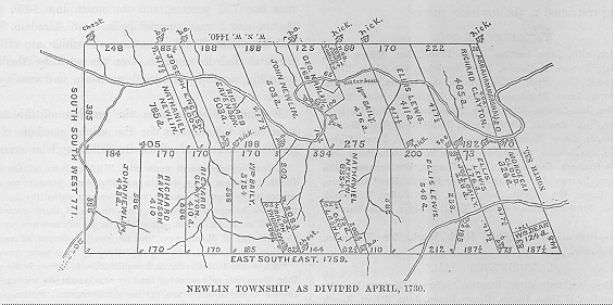
After his death partition was made of some of the lands of which he had thus died seized among his descendants, in manner following :


To Nicholas Newlin the messuage and tract of 500 acres in Concord.


To John Newlin the messuage and 62 acres in Birmingham, and also 946 acres of the tract on Brandywine (in two parcels).


To Nathaniel Newlin (in two parcels) 1620 acres of the tract on Brandywine.


To Jemima, wife of Richard Eavenson, 913 acres (in two parcels) of the tract on Brandywine.


To Kezia, wife of William Bailey, 375 acres in Marlborough, and also 851 acres (in two parcels) of the tract on Brandywine.


To Mary, wife of Richard Clayton, the other messuage and 33 acres in Concord, with 895 acres (in two parcels) of the tract on Brandywine.


To the children of Elizabeth Lewis 1133 acres (in three parcels) of the tract on Brandywine.


NEWLIN TOWNSHIP AS DIVIDED APRIL, 1730.


In the formation of Pocopson township, over 300 acres were taken from the southeast corner of Newlin and included in the new township. The portion thus included embraced the above-mentioned tract, originally conveyed to William Dean, and portions of the tracts of Mordecai Cloud and of the children of Ellis Lewis.


The name of this township is almost universally pronounced in this county as if written New Lin. This is erroneous. It should be pronounced with the accent on the first syllable,—New'lin. The incorrect pronunciation, however, is so fixed in the minds of the people that it will most likely continue to be used.


After William Penn had purchased from the Indians all the land in Chester County, he reconveyed to them a mile in width on each side of the Brandywine, from its mouth up the west branch to its head,—at least they afterwards claimed that he did,—but the writing was accidentally destroyed. In 1706 the commissioners of property, at the request of the inhabitants on Brandywine, purchased from the Indians their claim to these lands, from the mouth of the creek up to a certain rock in the west branch, in the line of Abraham Marshall's land. The consideration given was £100. Of this sum, £73 was then paid, and the remainder at a subsequent date, when a deed was executed. This rock in the line of Abraham Marshall's land was also in the line of the Society tract purchased by Nathaniel Newlin.


The Indians had a town or village a short distance west of this line, on the north side of the Brandywine, on the tract purchased by Newlin, and on that portion of it now owned and occupied by Lewis Marshall. It was on this spot that Indian Hannah, the last of her race in Chester County, dwelt for many years.


Nathaniel Newlin, soon after this purchase, commenced disposing of portions of his lands. Within six months he had issued warrants for some nine parcels, generally varying in size from 150 to 300 acres, softie of which were located on the creek.


A difficulty at once arose with the Indians. Their rights had only been extinguished to the rock in the western line of Abraham Marshall's lands, and they claimed that they were still the owners of one. mile wide on each side of the creek, from that rock up to its source, and that Newlin had no right to sell any of their lands, or to interfere with their rights in any way. No attention seems to have been given by Newlin, or the purchasers from him, to these claims.


At the next session of the Provincial Assembly, held at Philadelphia in the summer of 1725, the Indian chief Checochinican and others complained of the encroachments on their lands and obstructions in the creek by dams, and were heard by the Assembly. The account of this interview and the proceedings thereon, in the minutes of the Assembly, is so interesting we will give it in the language of the minutes themselves :


" 13th of 6 mo., 1725. The Petition of divers inhabitants of the city of Philadelphia, setting forth that the Proprietary having purchased of the Natives all the lands within certain bounds; and that the proprietary did afterwards release back to some of the said Natives a certain tract of land upon Brandywine, which said land is lately taken up and settled, to the great disturbance of said Natives, and praying that this House would take the same into their consideration ; was read and ordered to be considered this afternoon.


"Then the Honse was given to understand that the Heads of the said Indian complainants desire to attend the House in person, to set


TOWNSHIPS AND BOROUGHS, ETC. - 191


forth their aggrievances. Ordered, that they wait on the House at three o'clock this afternoon with their Interpreters.


"3 P. M., the House met:


" The Indians ordered to attend this afternoon, waited at the door desiring to be heard. Then chairs being placed for them, they were called in, and the Speaker, on behalf of the House, said: The House has had information that you have been with the Governor and Commissioners already. Have you received satisfaction ?'


"Indians (by interpreter.)—' We have not.'


"Speaker.—' What Is it then, that you have to offer to the House?'


" Indiana.—' When William Penn came to this country, he settled a perpetual friendship with us, and after we sold him our country, he reconveyed back a certain tract of land upon Brandywine, for a mile on each side of said creek, which writing was, by the burning of a cabin, destroyed; but we all remember very well the contents thereof: That Wm. Penn promised that we should not be molested whilst one Indian lived, grew old and blind, and died—so another, to the third generation; that is the way of expressing it—from generation to generation ; and now it is not half the age of an old man since, and we are molested, and our lands surveyed out and settled before we can reap our corn off; and to our great injury, Brandywine creek is so obstructed with dams, that the fish cannot come up to our habitations. We desire you to take notice that we are a poor people, and want the benefit of the fish, for when we are out hunting, our children with their bows and arrows used to get fish for their sustenance, therefore, we desire that these dams be removed, that the fish may have their natural course.'


" Speaker.—' How did you understand that writing to be ? That you should enjoy that land forever?'


"Indians.—' Not only we, but all the Indians understood it to be theirs as long as the water ran down that creek.'


" Speaker.—' Have you any thing more to say ?'


" Indians.–‘ No, but if you hear us not, we shall be obliged to come again next spring.'


" Speaker.- ' The House is inclined to do you all the favor which lies in their power.'


"Indians.—'We hone we are all friends, and desire to continue so, as long as we draw breath.'


"Then the Indians withdrew, and after some debate it was ordered that Francis Rawle, John Kearsley, and John Swift, go to James Logan, one of the Commissioners of Property, and inform him of the substance of the said petition, and matter complained of by the Indians; who being returned report that the said commissioner shows a very hearty inclination to accommodate the affair with the Indians, and although their right does not appear so clear yet they are possessed of such strong notions of it, that their is no divesting them of it; and, therefore, he is ready to do what he can to quiet their complaints, by granting the person who possesses the said lands, other " lands in the stead thereof.


" Ordered, That Francis Rawle and John Kearsley draw up an address to the Governor, on behalf of the Indians. Adjourned.


" 6th month 14th, 1725. The House met, etc.


"Then the members appointed yesterday in the afternoon, to draw up an address to the Governor, on behalf of the Indians, brought in the same, which was read and agreed to. Ordered, That the same be transcribed, and then the house adjourned to two P.M.


" Two o'clock P.M. The House met, etc.


"The address to the Governor on behalf of the Indians, according to order, being transcribed, is as follows, viz. : The Address of the Representatives of the said Province, in General Assembly met : May it please the Governor, As next to Divine Providence, the peace, happiness, and quietness which this Province first enjoyed, was owing to the wise conduct of the Hon. William Penn, our Proprietary and Governor, by procuring a good friendship betwixt him and the native Indians at his first arrival here, so by diligent care in cultivating and preserving the like friendship, the great happiness of peace has been hitherto enjoyed amongst us, when divers of the neighboring colonies have been obnoxious to the insults of the barbarous Indians, to the great damage of their countries ; and as the Governor's care and indefatigable pains upon all occasions, has been very conspicious to that good end, this House do address themselves on an unhappy dissatisfaction some Indians are under (who have always lived very peaceable with the inhabitants of this province), from an opinion that they are likely to be dispossessed of some lands they had long lived on and enjoyed on the river Brandywine, as also for being deprived of the benefit of fishing on the said river; all which they have by personal complaint laid before this House. And the House having taken into serious consideration the fatal consequence it may be to the peace of this Province, represented the same to James Logan, one of the Commissioners of Property, who has given the House ample satisfaction of his intentions to accommodate the difference with the said Indians. And we are fully satisfied (were it not for a purchase made of some part of those lands by Nathaniel Newlin, and his too wilful resolution to hold and settle the same), this part of this difference relating to the pretended encroachments on their lands would be immediately silenced. And notwithstanding this obstacle, we have reason to believe that Nathaniel Newlin will, in a very short time, become sensible, that it will be as much to his own private interest as of the Province in general, to be more condescending in this affair.


" But, whereas, there are dams or wares which do obstruct the passing up of fish to the place where the said Indians are settled, wlthout the verge of this Government, this house doth humbly request the Governor, that he will be pleased to exert his authority, in such manner as he shall think proper, for quieting and satisfying the said Indians, and preserving the ancient friendship between them and the inhabitants of this Province; and herein we also have that confidence as to hope that the Government of Newcastle, Kent, and Sussex, will so far think it conducive to their peace and quiet, that they will not fail to do what is necessary on their part, for the full settllng and composing this dissatisfaction.


"'Signed by order of the House, " WILLIAM BILES,


" August 14th, 1725.   Speaker.


" Ordered, That Thomas Chandler and Elisha Gatchell present the same to the Governor; who return and report that they had delivered the said address according to order, and that the Governor perused the same, and said he was entirely of the opinion of the House, and that he and his Council would use their utmost endeavors to satisfy these Indians, and that he was going down to New Castle, where he would order the persons concerned to move those dams complained of, which if they did not do, he would give orders to the King's attorney to prosecute them, and oblige them thereto, by due process of law."


No further proceedings were had at that session of the Assembly in relation to the complaints of the Indians.


The claims of the Indians were not adjusted to their satisfaction, and at the next session of the Assembly, in the spring of 1726, they again sought an interview and renewed their complaints, when the following proceedings took place:


"3d month 31st, 1726, the House met, etc.


" The Indians (who claim certain rights on Brandywine Creek) came to wait upon the House, and by a member sent in a paper they received from James Logan, and likewise a message that they were not satisfied therewith, and therefore made further application to this House for redress, which paper being read, the House went into a debate thereon, and after some time referred the further consideration thereof till to-morrow, and then the House adjourned till to-morrow morning at nine o'clock.


"4th month 1st, 1726, 9 A.M., the House met, etc.


" The House proceeded further on the consideration of the affair' relative to the Indians.


"Ordered, That Evan Owen go to the commissioners of property and desire some of them to attend, in order to inform the House what progress bath been made with Nathaniel Newlin towards an accommodation; who rammed and reported that he spoke with James Logan, one of the commissioners of property, according to order, and that he was ready to attend the House in order to acquaint them what had been done in that affair; who, being called ln, produced an Indian deed, dated 1685, signed by thirteen Indian kings, which conveys all the lands from Duck Creek to Upland Creek, alias Chester Creek, and as far back as a man could ride on horseback in two days ; and says he finds no footsteps of any reconveyance, neither in the land-office' nor upon record, but that in 1705 the Indians laid claim to all the lands from the mouth of Brandywine up the West Branch to the head, in breadth a mile on each side of that branch ; and afterwards the commissioners of proper ty purchased of the Indians all the lands from'


192 - HISTORY OF CHESTER COUNTY, PENNSYLVANIA.


the mouth of Brandywine up to a certain rock by Abraham Marshall's land for the sum of one hundred pounds, seventy-three pounds and eight shillings of which was then paid to their chiefs, and the remainder they paid yesterday, and the chiefs of the Indians signed a release, but said they wanted some instrument given to them that they might know what was theirs and be secure in it. But the commissioners told them it was not at this time in their power to make them any grant of the said lands, but that they should not be disturbed in their quiet possession thereof, neither by Nathaniel Newlin nor by any other person. That the commissioners bad told Nathaniel Newlin that it was in vain for him to pretend to that land, let the disappointment be what it would, so long as the Indians laid claim to the same, and would continue upon it; that after the Indians came up last year, and made the complaint, and a reconveyance was generally reported to have been given to the Indians, he went down to Chester and took certificates of all those who were reported to have seen and known of such a writing; which certificates being produced, and read in the House, none of which did amount to any certainty what that writing did contain ; but since the Indians had an imperfect idea of it, and a strong resolution to hold it, the commissioners used such means as they thought most likely to satisfy them, and continue them in the quiet possession of their claims, and for that end said they had agreed and accommodated the matter with Nathaniel Newlin, as far as was in their power to do at present ; and then withdrew.


" Then the House, after some debate, was of opinion that Nathaniel Newlin be sent for, to give some further assurance than what is done by the paper delivered yesterday that he will not molest the said Indians in their claims.


"Ordered, That John Wright send a letter that the House require his attendance to-morrow morning, and then the House adjourned till 3 P.M.


"3 P.M. The House met, etc. John Wright reported that he had sent a letter to Nathaniel Newlin, according to the order of the House. Adjourned till to-morrow morning at nine o'clock.


"4th month 2d. The House met, etc. Adjourned till 3 P.M.


"3 P.M. The House met. Nathaniel Newlin not attending according to the expectation of the House, after some debate, a motion was made and the question put, that if Nathaniel Newlin come not to town this evening he be sent for by the sergeant-at-arms, and that an order be forthwith issued under the Speaker's hand, and the sergeant be dispatched therewith this evening. Carried in the affirmative. Adjourned till 9 A.M.


"4 mo. 3d, 9 A.M. The House met. The Sergeant-at-Arms reports that Nathaniel Newlin came to town last evening, and will attend the House this morning.


"The House being informed that Nathaniel Newlin attended, he was called in, and said that he expected the value, and not the quantity only of land, in lieu of that the Indians claimed of his; and that he was to meet the Commissioners of Property this afternoon, and then doubted not but they should settle that affair to the satisfaction of the House, and withdrew, and then the House adjourned till three o'clock this afternoon.


"3 P.M. The House met, etc., Nathaniel Newlin attended, and being called in, delivered on the table a paper subscribed with his hand, which being read, cloth declare and promise that neither he nor his heirs will, by any means, disturb or molest the Indians in their possessions or claims. Then, after some debate thereon, it was


" Resolved, That the Indians be sent for, and the contents of the said paper be explained to them, and inquiry made whether it be satisfactory to them.


" Ordered, That John Wright and Samuel Hollingsworth acquaint them thereof, that they may attend forthwith; who return and report that they have been with the Indians, and that they are now attending with their interpreters; who being called in, the said paper was explained to them by the interpreters ; and they declared that they were well satisfied therewith, and they desired that the said paper might remain among the records of this house, and a copy thereof be given to them.


"Ordered, That a copy be made out accordingly, and signed by the Speaker, and delivered to them, and the original lodged in the House, which was done accordingly.


"And the Indians further said that they had been very much disturbed in their minds, but that now they were perfectly easy, since they found that this House would stand by them and see them righted.


"Then Nathaniel Newlin was called in, and acknowledged the said writing to them ; so they shook hands together, and parted fully reconciled, and then the House adjourned."


What recompense was made to Nathaniel Newlin by the commissioners of property for his promise " that neither he or his heirs would by any means disturb or molest the Indians in their possession or claims'' does not appear.


In 1729 the chief Checochinican, on behalf of his people, sent to the Governor a letter, wherein he complained that, notwithstanding the promise made by Nathaniel New-En in 1726, that they should not be disturbed in the free and peaceable enjoyment of their lands on Brandywine, yet that, contrary thereto, some of these lands had been sold, and they had been forbidden even to make use of timber growing thereon for the purpose of building cabins. He also complained that the town at the head of the Brandywine was surveyed to one James Gibbons, who said that he had an assurance of a conveyance from the commissioners of property, although James Logan had promised the Indians that no person should have a conveyance of lands within their claims.


What action, if any, was taken upon the complaint does not appear. The settlement of the lands on Brandywine' does not seem to have been much retarded, as soon after the death of Nathaniel Newlin, which occurred in 1729, the remainder of his tract purchased from the Society of Free Traders was divided among his children, and doubtless soon occupied by purchasers.


The Indian town at the head of Brandywine, mentioned in the letter of Checochinican, is supposed to have been situated about where the " Indiantown School-house" now stands, in Wallace township.


Not many years after the foregoing occurrences the greater part of the Indians removed from the county, and all trouble growing out of their claims ceased.


In connection with this affair, it may be mentioned that a bill was brought into the Assembly by Silas Prior and Ezekiel Harlan for their services as interpreters for the Indians on their visit to Philadelphia. The Assembly allowed a part of their charge, but censured them for assuming to act without authority.


Up to about the year 1738 the settlers here were assessed as of Marlborough or Bradford, according as they were on the north or south side of the Brandywine. In 1739 we find the " Society rate" in the assessment, and in February, 1740-1, the inhabitants petitioned to be formed into a township. This was granted, and the township named Newlin. It was, however, frequently written Newlinton.


TAXABLES MENTIONED IN "SOCIETY RATE," 1739.


Mordicay Cloud, Richd Barnatt, Philip Taylor, Anthony Baldwin, Thou Stubbs, James Shilds, John Harlan, George Bayley, George Pirce, John Standson, Robert Chaffin, John Beetle, Thos Willson, Wm. Wickerson, Moses Pyle, Wm Nicholas, Tho Smith, Magnes State, Danl ffew, David Eakhooff, Joel Cloud, George Ligget, Wm Littler, James Ligget, Robert Clark, John Withers, Jno ffilson, Robert ffilson, Saml ffilson, Jr., Widdow ffiemin, Thou Price, George Jeffrey, Richd Woodward, Wm Bemount, Isaac few, Robert Cole, George Rego, Boultus Miller, John Bayle, Guston Gurman, Richd Reynolds, Robert Willson, John Bradley, John Lard, Robert Thornbery.


freemen.—Job Moor, Stephen White, Wm Mansell.


TOWNSHIPS AND BOROUGHS, ETC. - 193


LAND-OWNERS, 1774.


Thomas Buffington, William Wickersham, James Smith, Charles Wilson, Jesse Taylor, John Buller, George Pierce, Thomas Baldwin, Thomas Wilson, Joseph Pierce, James Shields, William Nichols, Isaac Trimble, Mordecai Hayes, Richard Bernard, Job Pyle, Joseph Hayes, Joel Harlan, William Wickersham, Jr., Peter Wickersham, Caleb Hayes, John Bally, Henry Hayes, Thomas Shoot, David Eckhoff, William Eckhoff, John McGuire, Samuel Bailey, William Adkins, Jesse Bendy, Robert Chalfant, William Hannah, Robert Cowan, David Drenon, James Porter, Thomas Baldwin (tailor), Ebenezer Spikeman (Speakman ?), John Smith, Joseph Smith, Mary Shield.


NEW LONDON.


The township of New London, as well as Londongrove and London Britain, were doubtless so named because they were formed wholly or in part from the lands belonging to the London Company.


About the year 1704 some surveys were made to the westward of the London Tract for two or three persons, of whom Abraham Emmit was probably one. He purchased about a square mile of land, and had a mill on Elk Creek, which must have been one of the first in that neighborhood. Five hundred acres on the north side of this was surveyed for Robert Assheton. In 1714 a tract of 900 acres was surveyed for Michael Harlan, at Thunder Hill, afterwards owned by Robert Finney. While the line between the provinces remained unsettled, the Maryland surveyors frequently came into Chester County and laid out land for persons who claimed to be under the government of Maryland, and obtained patents therefrom for the same. This was the case with the Pleasant Garden tract of 740 .acres, though called 660 in the patent to Robert Hodgson. This was partly in Nottingham (now Elk) township, but mostly in New London, and lay nearly south of the Thunder Hill tract which joined it. Phineas Hodgson, a son of Robert, obtained about 400 acres of it, and this was divided between his sons, Robert, John, and Abel, in 1771. John Scott and John Mackey also became the owners of parts of the original tract. In 1720 several surveys were made for the settlers in the northeast part of New London, viz. : for Jeremiah Starr, 450 acres in the corner next to Londongrove, and south of this came Francis, Alexander, James, and Patrick Moore, with 200 acres each ; to the south of these, Susanna McCane obtained 300, William Reynolds 100, and Gabriel Alexander 100 acres. Some of these are now in Franklin township. In 1721 surveys were made for Thomas John, 150 acres, and Samuel Steel, 200. The last became the property of Francis Alison, and is supposed to include the site of New London village. In the central parts of the township lands were settled by Alexander Johnston, Hugh Cook, Roger Cook, and John Cook. A little east of the Pleasant Garden tract was one of 100 acres, also held by patent from Maryland, called ," Partners' Parcels." It belonged to the Hollingsworths, and by them was sold to Thomas Caldwell. In the northern part Samuel Campbell, James Shaw, Robert Mackey, Robert Finney, John Morrison, and others held land. The possessions of Susanna McCane were on the 
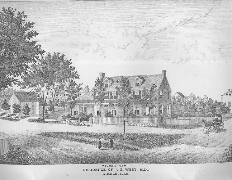
road leading from New London to Kimbleville, about where it crosses the line of Franklin township. She was the grandmother of Governor McKean, of this State.


- 25 -


The following correspondence is here offered as relating to land in this township


"Philad’ia 8th 12 mo., 1719-20.


"LOVING FRIEND, ISAAC TAYLOR.


" Thou wilt be as much tired perhaps with my letters as I am with the applications that occasion them. This comes by one Rennalds, who, coming in above two years ago, ventured (as he says by the advice of others) to sitt down and build on some land to the westward of the London Tract, which some tell him is vacant and others that it was surveyed to a merchant in London, Sir John Sweetapple, by II. Hollingsworth about 17 or 18 years agoe. If it be surveyed already, of which there appears nothing in the office, tho' tis certain such a survey was made about that time, he is willing to run ye hazard of it; but being apprehensive that it is not, he fears lest it should be laid out to some of those in whose favour thou bast directions from J. Steele ; but if that be the case, and the man be willing to submit to the same terms that others doe I have encouraged him to expect that it will not be surveyed to others, that not being our practice. I leave ye management of it to thee. I also refer to thee one Linton whose son has been with me to-day for a grant, but I rather choose that you should take measures in those cases there. The men, as I hinted before, have no great mint on their side; however, thou wilt take notice of what I have here said. I hope this will meet Col. ffrench and thee together, to whom are my hearty respects, as also to thyself, —from thy Loving ffriend,


"JAMES LOGAN."

" PHILAD'IA, Aug. 5th, 1720.


" LOVING FRIEND, ISAAC TAYLOR.


" William Reynolds and the widow McCane are now both here complaining heavily of a survey made by thy son John, on some land running along their claims, in a narrow, but very extended skirt, and cutting them off from the Barrens, which land they say has been long promised to them, upon their frequent applications to the office and thee,—that is, that when it was to be granted they should have the refusal of it. This survey, they say, is made for one Gabriel Alexander, who they alledge can have no right to it by grant or purchase, and if he had, they insist upon it they have not had fair play.


" Tho' thy son was the surveyor, yet as he has no authority but what is derived from thee, who art the appointed officer, believing that he would do nothing of that kind but by thy order, I thought it most regular to apply to thee, requesting some account of that survey, and by what authority it was done; for I depend on it that no man's solicitations of what kind soever can prevail with thee to survey the Proprietor's lands, without a warrant or full instructions from the office, for I need not observe to thee of what pernicious consequence such measures would prove, and therefore I should be unjust to thee to suppose it possible without stronger reasons than the application of those who conceive themselves injured. In ye mean time if that survey be not made on such a foundation, it will be well done of thee to save us the trouble of acquainting G. Alexander that he proceed not to make any improvement there. I request a line from thee in answer to this per first, which will oblige,—Thy real friend.


"JAMES LOGAN."

" August 10th, 1726.


" LOVING FRIEND, JAMES LOGAN.


"I received thine of the 5th of this month, last seventh day, by Elisha Gatchel, and had I not been well acquainted with the strange caprices of that hot headed person for above seven years, it would have been surprising to me, that any man should endeavor to lay a Block in the way of any persons having a small Tract of Land, on such just and Regular methods as the late survey made by my son John, for Gabriel Alexander was done, with which I am sure he is well acquainted.

"The case is thus: in March 1720, James Steele came to my house by thy order, and urged me to go down- towards Elk to make some surveys to prevent the Land being taken by Maryland. I told him that I was Indisposed, and was not likely to go myself, but would send my son John as soon as he was a little better recovered, (for he also had been sick.) and would procure a man to go along with him, that was with Henry Hollingsworth when he made the last surveys in those parts in 1704; and in the next month (i.e. April, 1720) John did go down, and having surveyed 200 acres to each of the four Moors, there was about 5 or 600 acres Left between those Lands and


194 - HISTORY OF CHESTER COUNTY, PENNSYLVANIA.


Robert Assheton's Tract, and by the Direction of Elisha Gatchel and John Churchman, who were on the spot with him, he divided it among the persons that were settled on it ;—to William Reinolds 300, to William Rees 100, & to Sam'l Steel and Gabriel Alexander 250 acres in one Tract. A few months after, Thomas Calwell and others that purchased Robert Assheton's 500 acres made a complaint to him, that my son had come within the limits of the said 500 acres, tho' he had the same chain man that H. Hollingsworth had, when he laid out the said Land and knew the bounds very well that Henry made and affrrmed that John had not gone within it : But because Tho. Calwell continued his clamor, I went down myself viewed the place the 26th of August 1720, and saw Assheton's northern line fair and well marked, and John had not interfered therewith, as can be provedi by persons yet Living. But Calwell procured one Joseph Meredith to resurvey Assheton's Land the 13th of March, 1720-1, and found that if it was run the length of the Patent, it would take in Alexander's house and Improvements ; then he applied himself again to Robert Assheton and he to James Steel who sent to me about it. Soon after, I being in Town, Steel told me that Robert Assheton was a Kinsman of ye Proprietors, and that the Commissioners would not allow of any Land to be confirmed there till Assheton's and was made up its full quantity ; and then he spoke to me to survey to Gabriel Alexander, the like quantity in the adjacent vacancy that Assheton took off, and in the month of October, 1721, Gabriel Alexander came to Jams Steel's office, and my son John and myself were present, and told James Steel that he was settled without the line that H. H. made for R. Assheton, as could be proved by good evidence yet Living, but if Assheton's Land must extend as far as Calwell claimed, it would take away his house and do him a very great diskindness. Steel's answer was I am sorry for that, but R. Assheton must have his full quantity according to his Patent, and Isaac shall survey to thee the same quantity that Assheton takes off in the vacant Land next thee, and that is all the kindness that I can do thee'; then turning to me be spoke to me to do it the next time I went that way, but if be has forgot to make entry of this, it is no fault of mine. I having no other business near the place did not go to do it, thinking it was in no great haste, but told Alexander that he having James Steel's promise, he might improve on that vacancy as soon as he pleased. Some time after, Robert Assheton sent me a letter wherein he desired me to go down and settle the bounds of his Land, but I being weak was not able to go. My son John told me that in the Spring, in 1725, he was in town and James Steel told him that he was desired by Robert Assheton, to desire me to settle a difference between the persons, that he had sold his land to and one Alexander, and he desired John, if I continued weak, to go down himself and do it, and make up what Alexander lost out of the next vacancy; a memorandum whereof John took on a bit of paper and has yet by him, and do believe J. Steel cannot deny it. Soon after John did go down and resurveyed Assheton's Land and ran a new line agreeing with the patent, which cutt off poor Alexander's house and Improvements; But the weather proving wet he could not stay then to survey to Alexander, so much of ye vacant Land as would make up what he lost. I was in hopes then that Alexander might have been at quiet, but some weeks ago he came up and told me, that unless I would send some body to survey his land he should be ruined, for while it lay as vacant Land, Reinolds and others would fetch all the timber off. As soon as John had opportunity, I sent him down and he surveyed as much of the vacant land as Assheton took off, in a very regular Tract, and what Gatchel is pleased to say of the irregularity of that survey, and of its being done without orders, is entirely false, for the first survey was made by thy own orders to me as other lands in that place in 1720 was done, and as or the new addition I have given thee the true reason.


"I know Reinolds pretended to take up all the vacant Land to ye westward of his, but I told him Alexander must be first served. And ye 2d clay of June, last, Reinolds came to my house again and looking very big, told me that he had been informed of a good piece of Land on Pequea, and hoped I would not hinder him from having that as I done of other Land, for he had money to pay down. I told him that I had begun a survey there for a gentleman in London, that paid his money 40 years ago and I had a warrant for it; and tho' he talked so much of his money, it was well known he had got it off other men's Land, for he settled a choice piece of ye proprietor's without Leave or License, cleared large fields very easy and made a great quantity of money off the corn that he raised, and then sold his Improvement to ye widow McCane for ninety pound ; then got 100 acres by, that was surveyed to another man. After that, he had an improvement in the London Tract that he sold to great advantage, and seeing that he had had so many places, he might let his neighbors have a little land to live on without finding fault; but if he could get a grant, he might have any vacant Land that was not yet promised. The person he then grumbled about was Thomas Reid, for whom I have I. Steel's order in writing, to accommodate him with a tract of land near Nottingham, as well as the country will now afford. As for the widow McCane, she has already — acres of good Land that was surveyed for Reinolds to ye very best advantage, and for her to desire the piece of land that poor Alexander had a grant for before she came to America, and has built a good house upon, (since he unhappily lost his first house and improvements, by means of a blunder made by H. Hollingsworth, with which Gatchell, her and Reinolds are well acquainted,) is really unaccountable. With Love and respects to thee and thine, I remain thy Loving ffriend.

" ISAAC TAYLOR."


On the 2d of August, 1726, Gabriel Alexander signed a paper to the following effect :


" I hereby agree to suffer Susanna McCaine to sow all the land she has now cleared on the vacancy by her, with come next season, and peaceably to carry off the same, she claiming no right of possession thereby."


The dispute did not end here, and on the 17th of the same month a number of his neighbors signed a recommendation, stating that ''Gabriel Alexander has lived in this neighborhood odds of six years preceding this date, and we, the subscribers, never knew him to defraud no manner of person, or wrong any man," etc. : " John Betty, Morgan Leyson, David Emmit, William Gilespy, Abraham Emmit, Sr., John Scott, Jr., James Smith, James Andrews, Josias Emmit, John 'rood, John Cain, Joseph Hedges, and Gayen Miller." Nigel Gray also wrote- to Isaac Taylor a quaint letter of recommendation of' Gabriel Alexander. The following spring Abraham Emmit granted a warrant to arrest 'William and James McKean for trespass, on the complaint of Gabriel's son, Zaccheus, against which Elisha Gatchel protested, declaring that the Alexanders had no right to the land. In 1739, Thomas McKean appears to hold a part, if not all, of his mother's land.


An attempt to trace the title to the present owners of the McKean land was not entirely successful. Prior to 1783 it passed into possession of James Smith, Jr., of Burlington, who in that year conveyed 187 acres in New London to John Kemble. The heirs of the latter sold 115 acres in 1812 to Edward Owen, whose administrator conveyed the same in 1821 to David Woodington. William E. Haines purchased in 1823, and sold in 1869 to Joseph Peirce, the present owner.


In 1725 the township was divided, and London Britain taken therefrom. About 1733 the boundary on the Lord], between Londongrove and Elk Creek, was established, running from the northeast corner of John Todd's land to the southeast corner of Fagg's Manor, and thence to the creek. This was granted on petition of William McKean, William Gillespy, John McClenachan, Samuel Steel, Lazarus Finney, George Correy, John Henderson, James Futhey, Josias Emmit, John Todd, and several others. In 1775, George Correy and others presented a remonstrance against the petition from London Britain for taking some of the territory into the latter. In 1724 the assessment of New London included the territory of London Britain. In 1852 the township of Franklin was taken from New London, since


TOWNSHIPS AND BOROUGHS, ETC. - 195


which the latter contains none of the original London Company's land.


TAXABLES IN 1725.


Gayen Lepeer, Robert Linton, Hugh Stewart, John Beetem, Peter Hegot, James Mesirs, Wm Bowhannin, Wm Steels, Gabriell Alexander, Robert Smith, Thomas Caldwell, Jean Scott, John McCrakan, John Cook, Neill Gray, James Donnell, Susannah McKeen (widdow), Sam]. Carson, John Croghton, Wm Renals, Patrick Moor, Alexander Moor, James Moor, William ffeil, John Todd, John Mongomery, John Henderson, Tho. Black, James Makanless, Nicholas Curry, Henry Small, John Steel, John Clenoughan, Robt Messar, Josias Emmit, Hugh Barkley, Abraham Emmit, David Emmit, John Gelaspy, Robert Robison, James Smith.


Freemen.—Zechariah Alexander, Ninian Steel.


TAXABLES IN 1753.


John Scott, Esqr, Alexander Johnston, Wm. McDowell, James Purtle, Matthew Porterfield, John Currey, John Moore, Matthew Logan, Widow Fury, James Reed, Robt Anderson, Alexandr Walker, John Sturges, Peter Gubby, James Donald, Widow Dicky, Robt Linton, Rob' Finney (saddler), Widow Finny, John Morrison, Thos Minor, Sam' Steel, Robt Finny, Junr, John Moore, James Sloan, David Em-mitt, Alexandr McCurdy, Henry Small, James Whitecraft, Andrew Henderson, John Henderson, Thos Cooke, Joseph Cook, James McCanless, Win. Downard, John Todd, Alexr Craige, James Harrison, Robt Gillmore, Robt Kelton, Geo. Curry, Robt Jurdain, Wm. Commons, John Menah, Humphry Riske, James Moore, Joseph Moore, Joseph Allison, James Welsh, Rob' Taylor, Wm. Gelespie, John Porterfield, James Mears, Michal Montgomry, Arthur McClure, Wm. McDowel, senr, James Jurdan, junr, nos Finny, Jno Fleming, Sam]. Betty, Thos Magee, Widow English, John Moore (schoolmaster), Robt Allison, Widow Steell, John. Moore (cooper), James Fariss, Hugh Canble, Robt McKee, Andw Scott, Robt Latimore, Win. Young, senr, Win. Young, Junr, John Bunting, Alexander Morrison, John Smith.


Poor men.—James Brown, John McKenny, John Montgomery,. John Moore (weaver), John Branagan, Thos Welsh, James Cannon, James Johnston, Edward Boyle, Owen McGrew, Win. Reed, Win. Alexander, David Shear', Patrick Hay, Felix Gallaher, James Achan, Cornelius Welsh.


Freemen.—Joseph Haze, Richd White, William Bietts, James Rusk, Darby Dorgan, Jno Moor, Joseph McDowel, David McDowell, Andw Small, James Small, Thos Sturd, Joseph Boyd, Charles Bravard.


LAND-OWNERS, 1774.


George Alexander, Francis Alison, William Beaty, David Buchanan, David Correy, Robert Correy, George Campbell, Thomas Campbell, Win. Cummings, Allen Cunningham, Patrick Culbertson, John Dickey, Thomas Donelson, Walter Davis, Robert Finney, Robert Finney, Jr., Walter Finney, Thomas Fulton, Samuel Floyd, Joseph Furey, James Falls, John Gibson, Thos. Gilmore, Peter Gobby, Robert Giffin, Robert Gilmore, Robert Graham, James Hutchinson, James Hughs, Alexander Hughs, Thomas Hughs, David Hutchinson, Eliza Henderson, Alexander Johnston, Esq., Samuel Kennedy, John Lemon, George Lesley, Wm. Montgomery, John Montgomery, John McDowell, William McDowell, Wm. McDowell, junior, Ephraim Morrison, Alex'r Morrison, James Moss, Arthur McClure, Thomas McConnell, Joseph Moore, Robert Moore, Robert Montgomery, Michael Montgomery, Joseph Morrison, John Menough, George Mitchell, Charles Newcome, John Pennock, James Reed, William Reed, John Robinson, John Scott, Andrew Scott, William Steel, Jeremiah Starr, John Small, John Smith, John Todd, Joseph Thompson, Robert Wilkins, Matthew Wilkins, Thomas Wiley, James Whiteraft, Archibald Woodside, Agnes Young.


NEWTOWN.


TAXABLES IN THE ASSESSMENT OF 1715.


Daniel Williamson, Rees Howell, William Bevan, David Thomas, William Phillips, Thomas Rees, John Rees, Junr, Lewis Rees, Lewis Lewis, Evan Lewis, William Lewis, John Rees, John ffawkes, Morgan James, Lawrence Peirce, Daniell Williamson, John Williamson, James Price, John Meredith, Edward Thomas, William Thomas.

Ffree Men.—John Goodwin, Adam Treheall.


This is now a part of Delaware County.


NOTTINGHAM.


At a meeting of the commissioners of property at Philadelphia• 14th of 11th month, 1701.


Present, Edward Shippen, Griffith Owen, Thomas Story.


JAMES LOGAN, Secretary.


"Cornelius Empson for himself and several others to the number of 20 families, chiefly of the county of Chester, proposes to make a settlement on a tract of land about half way between Delaware and Susquehannah, or nearer the latter, being about 24 miles distant from New Castle, on Octorara river, in case they may have a grant of 20,000 acres in the said place, at a bushel of wheat p hundred rent or five pound purchase, to be after at a shilling sterling p annum ; which being duly considered and the advantages that might arise thereby, by rendering the adjacent land more valuable, and encouraging the settlement of Susquehannah river ;—Tis proposed that they shall have 15 or 20,000 acres at £8 p 100 or at 2 bushels of wheat rent p annum, the first year for their encouragement to be free of rent, or one year's credit to pay the purchase money. He agrees to the price of purchase, or to a bushel and an half p C. p annum; But is referred to their further consideration."


The offer of the commissioners having been accepted, the, following warrant was issued :


" BY THE COMMISSIONERS OF PROPERTY. "


Pennsylvania :


[SEAL.] " Whereas, Cornelius Empson and divers others, ye Inhabitants of this province herein after mentioned have requested us that we would grant them to take up a certain tract of land in this province: situate between the main branch of North East river and Octorara creek, for which they have agreed to pay eight pounds for every 100 acres within one year after the date hereof, and 1s. sterling for a yearly quit rent for every 100 acres forever after, or in case of non-payment of the sd money that they shall hold the sd land under ye yearly rent of 2 bushels of good winter wheat for every 100 acres, to be paid yearly at some navigable water or landing place on Delaware, ye sd rent to commence within one year after the date hereof.


"These therefore are to authorize A require thee forthwith to survey A lay out in ye sd place to ye sd Cornelius Empson 1000a, to Jno. Richardson 1000a, to Jas. Brown 1000a, to Henry Reynold 1000a, to Wm. Brown 1000a, to John Bales 1000a, to Edward Beeson 1000a, to Jas. Cooper of Darby 1000a, to Randal Jenny 1000a, to Andrew Job 1000a, to Jno. Churchman 1000a, to Ebenezer Empson 1000a, to Jno. Guest of Philada. 1000a, to Joel Bayley 500a, to Robt. Dutton 500a, to Saml Littler 500a, to Messer Brown 500a, and to the Proprietary for his own proper use 3000a, if the land will hold out ;—all in one tract with sufficient allowance for Roads according to the method of townships; beginning at the Northern Barrens between the sd Branch A Creek A bounding it to the southward with an east and west line parrallel as near as may be to the line of ye Province, A northward next the Barrens with a line also parrallel to the south bounds, A in the sd tract run 18 several divisions each of 1000a, to be taken by the several p'sons afores'd by Lott, joining two purchasers of 500a to one Lott A dividing the propr'y into 3 several shares, whose Lotts thou are hereby authorized to draw ;—and make returns of the several Lotts into the General Surv'rs office at Philad'a, where this warrant is to remain & a copy thereof to be delivered to thee certify'd by the See'y, who is also to take a Duplicate of thy return into his office; which survey to be by thee made shall in case the s'd psons fulfill the agreement afores'd and settle the same within two years after the date hereof, be valid, otherwise shall be void A of no other effect than if the same had never been made nor this warrant ever granted.


" Given under our hands A the seal of the Province at Philad'a, the 7th of the 1st mo., 1701 [March 1702].

"EDWARD SHIPPEN,

" THOMAS STORY,

" JAMES LOGAN.


"To HENRY HOLLINGSWORTH."


In pursuance of this warrant a large tract of 18,000 acres was laid out in the 3d month (May), 1702, commencing at a point seven and one-half miles, or thereabouts,


196 - HISTORY OF CHESTER COUNTY, PENNSYLVANIA.


west of the northeast corner of Maryland, and extending thence to the Octorara, a distance of about ten miles. The south line was nearly straight, but there were offsets in the north line, which were probably made to include good land and leave out some of the " barrens." In the widest part the tract extended about three miles from north to south. A street or road was laid out through the middle, running parallel to the south line, and the tract was again divided by lines extending north and south from the street. There were thirty-seven of these divisions, so that they contained, on an average, somewhat less than 500 acres each. As intimated in the warrant, we may suppose that the purchasers drew lots for their shares ; but, there being twice as many divisions as at first proposed, it happened that a purchaser of 1000 acres had to take two tracts, which in many cases did riot lie contiguous. From a draught the following appears to have been the result of the lottery :


Lots 1, 2, and 3, at the west end, are not named, but 2 and 3 are supposed to have been John Guest's; No. 4, at the southwest corner, Edward Beeson. Then, commencing at the northwest corner, and proceeding eastward, we have No. 5, Henry Reynolds; 6, John Richardson; 7, proprietary ; 8, Cornelius Empson ; 9, proprietary ; 10, Ebenezer Empson; 11, Joel Bally; 12, Jas. Cooper; 13, proprietary; 14, James Brown ; 15, Randal Janney ; 16 and 17, John Churchman. Then, returning to the southwest corner, and proceeding eastward on the south side of the street, we have lot No. 18, adjoining No. 4, both in the name of Edward Beeson ; 19, Henry Reynolds; 21, John Richardson ; 21, proprietary; 22, Ebenezer Empson ; 23, William Brown ; 24, Cornelius Empson ; 25, proprietary ; 26, James Cooper, partly opposite No. 12; 27, James Brown ; 28, William Brown, opposite No. 14; 29, Robert Dutton and Samuel Littler ; 30, a common lot reserved for a meeting-house; 31, Robert Dutton and Samuel Littler; 32, Andrew Job ; 33, William Brown ; 34, Randal Janney; 35, Andrew Job, the southeast corner; 36 and 37, a double lot, on the north side of the street, and opposite the last three, John Bales (or Beals), being also next to John Churchman, No. 17.


Messer Brown's name is not mentioned in the draught, but his father's, William Brown's, being given three times, it is probable that the shares of both are in the father's name. Messer (or, more properly, Mercer) was not then of age. The main branch of North-East Creek passed through lots Nos. 13, 14, and 28. The brick meeting-house stands on the north end of lot No. 30. This large tract is said to have received the name of Nottingham when first laid out, and it was doubtless so called in remembrance of the town or county of Nottingham in England. It was supposed to be in Pennsylvania, but when the line was finally determined the greater part of the tract fell into Maryland. To those who are somewhat familiar with the line, it may be interesting to know that the eighth mile-stone stands on and near the north side of John_ Beals' double lot. The ninth mile-stone is not within the original survey, there being an offset here of near a mile in width. The tenth mile-stone stands on John Churchman's lot No. 16 ; the eleventh on James .Brown's lot No. 14 ; the twelfth on James Cooper's lot No. 12 ; the thirteenth on Ebenezer Empson's lot No. 10 ; the fourteenth on the north end of Cornelius Empson's No. 8. Owing, no doubt, to the variation of the compass, the lines, which were intended to be parallel to the Maryland line, run a little south in going westward, and although the north line of lots Nos. 5 to 10 was straight, it crosses the State line between the fourteenth and fifteenth mile-stones. Lots 11 to 16 were bounded on the north by a straight line, which at its eastern end is a little more than three-quarters, but at the western end less than half a mile, north of the line.


The land to the northward of these lots was described as " back of Nottingham," and was subsequently taken up in various-sized and mostly irregular tracts by settlers, and was at length included in the township of Nottingham.


The early surveys were for a long time known by the distinctive appellation of " Nottingham Lotts."


"To the Board of Property in Philadelphia :


"The Representation & Petition of a number of the inhabitants of East & West Nottingham townships, in Chester county, who possess the Northern part of the land called Nottingham Lotts


" Respectfully Sheweth,-


" That Whereas, at the Instance and Request of a certain Cornelius Empson, on behalf of himself and sixteen others in Company, a Warrant ,was granted by the Commissioners of Property for William Penn, Esquire, Proprietor and Governor, bearing date the 7th of the first month 1701, for laying out about 18,000 acres of Land, situate towards Octorara creek, which within six months after was surveyed, divided into upwards of 30 Lotts, called Nottingham, and quickly settled. The situation whereof happened to be on & near the Boundary between the Provinces of Pennsylvania and Maryland ; which boundary then & for many years afterwards, remained unsettled; Doubts arising between the Proprietaries respecting the same, which appears to have prevented the Purchase Money being received from the settlers, and Patents being issued to confirm the lands to them according to the original contract ; offers having been made (as we find) on their part at divers times within the course of 30 years after the settlement, for a Compliance with their agreement, which. did not avail. And Whereas on the settlementof the Boundary Line in latter Time, twenty of those Lotts, called 490 acres each, (besides two double Lofts of 980 acres each, at the West End towards the River Susquehanna), fell entirely into Maryland, together with the Major part of the remaining nine Lotts and two double Lotts; leaving of the whole only the Quantity of 1200 acres and the usual Allowance or thereabouts in Pennsylvania; being the Northern part of the last mentioned Lotts, as may appear by a Draught of the same herewith to be exhibited; which remainder is chiefly of the thinnest Part of the Land. And Whereas Times of Commotion & Difficulty happened to commence near the Time when the said Boundary Line was confirmed, preventing for some years our application to have those Lands confirmed to us which we hold in right of our Predecessors under the above hinted description, and being now desirous to have them confirmed we have agreed to represent our case herein to the Board of Property : and as it will (perhaps) appear different from the case of located Lands not Patented in other Parts of the State, for the Reasons above, we request you will be pleased to take the same under consideration and view the circumstances relative thereto; some further of which with submission we crave Liberty to mention,-


"1st. It appears by a Minute of the Commissioners of Property aforesaid, made about 8 weeks before the Date of the Warrant, they considered that in those early times advantage might arise to the Proprietaries Interest from a Grant & settlement of those Lands, by rendering the adjacent Barreny Lands more valuable and encouraging settlements on Susquehanna. 2d, It also appears that within the time proposed a number of our Predecessors did remove hither, enduring much hardship by taking their Families what was then accounted a great Distance back in the wilderness beyond the other Inhabitants, and therefore remote from supplies of necessary Provisions, having themselves a Road to clear near forty miles, where no Road was before, and being subject to many other Difficulties; facilitating the settlement of other Proprietary Lands in those Parts of a mean Quality, whereby the Interest growing on the purchase money stipulated for those Lands- hath been increased to much larger sums than would otherwise have been : And Lastly we conceive by the Tenor of our Predecessors Agreement, that if the Purchase money which they contracted for on account of those Lands was not paid within the time limited, the Purchasers were obliged to hold the Lands subject to an annual Quit rent payable in wheat; And a Law having passed or been enacted by the Legislature to abolish or take away Quit rents, in Lieu whereof additional Land Taxes have been


TOWNSHIPS AND BOROUGHS, ETC. - 197


levied and collected on the estates of the Inhabitants. Under all these circumstances we apprehend we have reasonable grounds to expect a confirmation of our Title to the aforesaid Lands on the most favorable terms. Therefore we humbly hope this Board or others whom it may concern, will consider our case, and the circumstances thereof as above mentioned, and direct herein as in wisdom and Prudence they may judge expedient; whose favourable Notice will be kindly received and gratefully acknowledged:


" Dated in Nottingham aforesaid, the 14th day of the month, called September, 1787, and signed—


"Levi Kirk,

Roger Kirk,

Anthony Chananes:

Eli Kirk

Levi Bally,

John Churchman,

Jacob Brown, Jr.,

Jacob Brown,

Daniel Job,

Isaac Haines,

Thomas Scott

Philip Tanner

Jeremiah Brown,

George Churchman,

William Churchman,

William Barrett,

Jacob Haines."


A petition of the same import waChamnessed to the Assembly of Maryland by the possessor of those parts of the Nottingham lots in that State, and an act was passed in 1788 to confirm their lands to them under certain condWilliamThe Pennsylvania board of property ordered a resurvey of the .north ends of the lots preparatory to granting patents :


"The warrant for resurveying the North Ends of the Nottingham Lotts is Dated the 29th of November, 1787, and to me directed ; In consequence whereof they were soon after resurveyed, viz.: for Isaac Haines, the North End of the Lotts which were originally numbered 7 & 8, called Triangle, containing 31 acres and allowance; For Jacob Haines, the N. End of the Lot No. 9, 40 acres and 48 perches and allowance; called North Range; For Jacob Brown, the North End of Lott No. 10 and part of No. 11, 66 acres 130 perches, called Chippenham ; For Jacob Brown, junior, the Northern part of Lot No. 11, 129½ acres and allowance, called Carpenter's Hall ; For Levi Bally, the N. End of the Lot No. 12, 82½ acres and allowance, called Swanzey, and for Daniel Job part of the same Lot, 60 acres 36 perches, called Uzzah ; For John Lewden, 112¾ acres and allowance the North End of the Lot No. 13, called Rockland; and for Eli Kirk part of the same Lot, 45½ acres and allowance, called Mount Rocky ; For Roger Kirk the North End of the Lot No. 14, 141¼ acres A; allowance, called Stony Grove; and for Levi Kirk, part of the same Lot 38 acres, 72 perches & allowance, and also part of the Lott No. 15, 46 acres 62 perches—in both 84 acres 132 perches and allowance, called North Range ; For William Barrett the North End of the Lot No. 15, 140¾ acres and allowance, called -- ; For William Churchman, the North End of the Lot No. 16, 217 acres and allowance, called Fair Hill ; For George Churchman, part of the same Lott, 28 acres and allowance, called Trapezium ; and for John Churchman, part of the same Lot, 18 acres 100 perches, called Oblong; For Thomas Scott, 25 acres 140 perches and allowance, part of the North End of John Beal's double Lot, No. 36, 37, called Scott's Range; For Jeremiah Brown, part of the same Lott, 21 acres 47 perches and allowance, called Brown's Forest; For John Harvey, 53 acres 35 perches and allowance, called Harvey's Hope ; Part of the same and at the East of the same for Philip Tanner, 45 acres 21 perches. Including all that part of said antient Lots which lies in Pennsylvania, the Eastern part of which (as far as North East creek) lays in East Nottingham ; the other' part in West Nottingham, Chester county, 1345½ acres and allowance of six per cent., according to the Draught annexed. Certified the 20th of the 9th mo. 1791. By


" GEORGE CHURCHMAN."


Nottingham is not mentioned in the assessment of 1715, but in 1718 both East and West Nottingham appear. In each list there are several " adjacent inhabitants," which were probably those outside the original survey. In 1734-5 Londonderry was separated from Nottingham.

From a petition dated Feb. 25, 1728-9, respecting the bounds of West Nottingham, it appears the township extended beyond the Octorara Creek prior to the erection of Lancaster County. In 1833 a portion of East Nottingham was taken to form Oxford borough, and in 1853 Hopewell borough was partly taken from it. In 1857 it was still further reduced by the formation of Elk township.


James Trimble, of Fairville, writes in 1870 :


" At one time during the Revolution Smallwood's division of the American army occupied Friends' meeting-house at. Nottingham as a hospital. The surgeons in charge, some four or five in number, were quartered at my grandfather's house, one of them being Peter Yarnall, then a reckless, swearing young man. On one occasion they persuaded my grandmother to sell them a blanket for a wounded soldier who had none, Peter remarking that as the poor soger was lying in the gallery, he thought the blanket would not be profaned.' For this offense, however, she had to give an acknowledgment."


EAST NOTTINGHAM TAX-RATE, ASSESSMENT OF 1722.


Samna Robinett and} land in Sadbury}

Robert White

John Hugg

Eliza Job

Elisha Gitchel

Jacob Beals

John Beals

Joseph Jones

Tho. Oldman

John Churchman

Benjamin Chandlee

Jacob Job

Sam: Litter.

John Whit

Aaron Coppock

Moser Brown

Hugh Morgan

James Crosswell

Wm. Beal

Arthur Barret

Morris Rees

Samll Calbrith

John Towson

John Cook

Rob : Oldham

Wm. Frances

£ s. d.


0 11 0

0 3 6

0 6 3

0 15 0

0 16 3

0 10 0

0 8 9

0 4 0

0 10 0

0 15 0

0 6 0

0 5 0

0 12 6

0 7 6

0 6 0

0 12 0

0 6 3

0 1 0

0 6 6

0 7 6

0 5 0

0 1 3

0 5 0

0 6 0

0 6 0

0 1 0


Alexander Martin

James Ogilbe

John Ruddal

Thomas Job

John Read

Archelus Hamilton

James Smith

George Harrison

Philip Taner

Thomas Read

John Eldrick

Stephen Stapler

William Hogg


Freemen.


John Brabson

Sam: Whiting

Peter Hastings

John Butterfield

Charles Goss


Non-resident Land


Abrahim Bickley, 200a.

Richard Jones, 200a

Samll White, 100a

£ s. d.

0 1 0

0 4 0

0 6 0

0 4 0

0 2 6

0 3 0

0 2 6

0 4 0

0 3 6

0 3 9

0 4 6

0 7 6

0 15 0


0 9 0

0 9 0

0 9 0

0 9 0

0 9 0


0 3 9

0 3 9

0 1 10


TAXABLES, 1753.


Elisha Gatchell, Esqr, Rowland Rogers, John Day, Elisha Hughes, Benjamin Chandlee, John White, Junr, Thos Willson, jour, Cotty Chandlee, Messer Brown, Thomas Willson, acne, Will. Kirk, Sam. England, Edward Oldham, Robert Oldham, Widow Ogilbie, Widow Boggs, Wm Feries, Michal Askin, Matthew Taylor, Sam. Byers, Andw Byers, David Gault, Hugh Allison, John Robison, Will. Bain, John White (sawyer), Joseph Tremble, Timothy Kirk, Neal McCaskey, Thos Barrett, Geo. Churchman, Danl Brown, James gilbiem Churchman, John Slater, Nathan Brown, Wm Montgomery, John Rees, Wm Shepard, James Shepard, Robert Shepard, Thus Churchman, Wm Chandlee, Wm Pugh, John Pugh, John Crawford, Widow Boyd, John Cunningham, Thus Oldham, Senr, John Oldham, John White (Poplar Hill), Robert Black, Henry McCulley, George Robinett, Zachary Butcher,.Moses Karr, John Glen, James Cowden, Widow Erwin, Widow Clendenan, Widow Ewing (John's), Archible Job, James Steel, Robert Mackey, Abigail Price, Eiisha Gatchell, Junr, Hugh Mehaffey, Gydeon Thompson, John Lawson, John Hathorn, James Smith, David Butcher, Moses Sharp, David Long, David W harry, John Carson, Samll Hathorn, John Smith, Widow Porter, Josias Etomitt, Widow Mary Tanner, Philip Tanner, Robert Harvey, Wm Scott, Thos Scott, Benja Willson, John Hill, Wilm McWilliams, John Chuddy, Patrick Pease, or Skein, Bryan McMurray, John Champbell, Sampson Moore, Richard Sidwell, Patrick Poor, Robert Erwin, Thomas McCartney, James Howard, James Willson, Gilbert Buchanan, Widow Crawford, Wm McCain, John Knox, James Hodders, Gayon Morrison, Finley McGrew, Matthew Willson, Hugh Thompson, James Wharrey, Samll Dickey, Mathew Seaton, David Hogg, David Junkin, Bartholomew Dorough, Widow Jean Woodroe, William Betty, James Adams, James Glasgow, James Carnage, Wm Jenkins, Michall McGlooughlin, James Paterson, James Skiventon, Wm Guy, John McMullen, Robert Maxwell, James Caldwell, Robert Hunter, Widow Calvin, Benj. Elliot.


Inmates.—John Pugh, senr, John Butterfeild, John Given, Nathl


198 - HISTORY OF CHESTER COUNTY, PENNSYLVANIA.


Willson, Henry Knight, John Corrans, Hanse Miller, John McMullen, Thomas McMurry, John Wakefield, James Brisland, Edwd Parker, Patrick Brown, Wm Owen, Roger Hart, Neal Mcdonnell, John Sutliff, David Watson, Jacob Grundall, Richard Lunny, Sam. Allen, David Humphrey, Peter Bambridge, Will. Work, James Noble, John McClelan, Joseph Draynon, Robert Coughran, Francis Shearer, Dan' King, Barthol. Dirrum, Hugh Reynolds, Sam. Willson, Thomas Carson, John Sutton.


Freemen.—Wm White, Joshua White, Jonathan White, Zebulon Oldham, Thos Davis, Wm Coyle, George McKindly, Wm Young, James Campbell, John Shannon, Edwd Taylor, John Steen, Wills, Forsythe, Hezekiah Rowles, Robt Allison, Jeremiah McMachan, Daniel McClevanan, Thos Martin, Thos Kelly, Wm Brisby, William Brown, John McWilliams.


LAND-OWNERS, 1774.


Rob't Alexander, Henry Erskine, Jas. Anderson, Jeremiah Brown, Ahem Bunting, David Brown, Wm. Bean, Mercer Brown, Wm. Brown, Th. Barret, And'w Boyd, And'w Brians, Th. Baldwin, Robt. Calvin, James Calvin, Thos. Churchman, Wm. Churchman, John Clendening, John Crawford, Elijah Cole, John Churchman, Benj'n Chandlee, George churchman, Samuel Dickey, Samuel Dickey, jr., John Day, Robert Dorrough, Joseph Drenin, Sumuel England, John Erwin, Henry Ewing, Robert Ewing, Thos. Ewing, Robt. Erwin, John Fulton, Jos. Gardner, Thos. Gilliland, Robert Graham, Elisha Gatchell, Win. Gibson, Joseph Gatchel, David Gatchel, Archibald Glover, Jas. Rudders, John Rudders, James Harkness, Sam'! Hutchison, Samuel Hill, John Hathorn, Robt. Harvey, Patrick Hamilton, Wm. Hilles, Mary Hughs, Matthew. Henderson, John Johnson, Mordecai James, David Junkins, Archibald Job, Timothy Kirk, Abner Kirk, Mary Kirk, Hugh Logan, John Lawson, Geo. Ligate, James McCorkle, John McClavery, Henry McCormick, Henry McCauley, .James McCormick, James Morrow, Sampson Moore, Jean McKee, Robt. Maxwell, James Mealey, Geo. Mitchell, John McConkey, William Mackey, James Mackey, James Montgomery, John Mills, Finley McGrew, John McBeath, Geo. Monroe, Jas. McLaughlin, John Ogleby, Robert Oldham, Margaret Patterson, George Passmore, John Pew, Joshua Pugh, William Pennell, Edward Parker, Josiah Porterfield, Rowland Rogers, William Rogers, Wm. Rutherford, Wm. Ramsay, Hezekiah Rolls, Isaac Rodgers, James Steel, Thomas Scott, Hugh Sidwell, Richard Sidwell, James Smith, Joseph Smith, Robt. Shepherd, Wm. Shepherd, Thos. Sharp, Hugh Thompson, Philip Tanner, Joseph Tanner, Joseph Trimble, Samuel Wilson, Francis White, John White, John White, jr., Jonathan White, Robt. Wilson, David Wherry, James Wilson, David Watt, Benj'n Wilson, Charles Williams, Thomas Wilson, Thos. Youl.


WEST NOTTINGHAM TAX-RATE, ASSESSMENT OF 1722.


Hugh Sidwel

Richard Beson

Jeremiah Brown

Wm. Brown

Joseph Rains

Wm Harris

Henry Reynolds

Thomas Brown

Henry Parsons

Richard Harold

James Robinson

Sawn Kirk

Wm. Hanby

James. King

Joseph Rich

Hugh Sidwell

Jur Alexander

Ross

Robt. Sinkler

£ s. d.

0 10 0

0 11 3

0 8 0

0 14 0

0 12 6

0 6 0

0 10 0

0 4 6

0 5 0

0 5 0

0 6 0

0 5 0

0 6 0

0 6 0

0 15 0

0 8 0

0 6 6

0 6 0


Joseph Pain

Wm. Brown, Jur

John Sidwell

Richard Brown

Daniel Brown

Sawn finley

James Brown

John Miles

Walter Wale

Samll Stone

Robert Love


Non-resident Land


Thomas Sisam, 500a

Abraham Bickley,300a

Wm. Beason, 500a

James Cooper, 250a

£ s. d.

0 3 0

0 7 6

0 6 6

0 6 0

0 3 0

0 2 6

0 4 0

0 2 0

0 2 0

0 3 6


0 2 6

0 8 9

0 5 3

0 8 9

0 4 4


TAXABLES IN 1753.


William Allen (smith), Henry Reynolds, Robert Creswell, Isaac Brown, Jeremiah Brown, Jer. Brown, junior, William Coles, David Patten, James Craige, Samuel Poak, Robert Mowberry, Robert Hyndman, Robt. Lyon, John Lyon, William Poak, James Barns, Widow Barns, Abraham Scott, James Barclay, David Poak, David Allison, John McClintock, Andw Steel, George Rankin, Izabel Blear, Wm. Young, Robert Welsh, James Edmeson, Patrick Reah, John Kirkpatrick, Joseph Josephjunr, John Harris, Hugh Kirkpatrick, David Edmeston, John Alexander, John Kanidy, James Poak, Wm. McMasters, John Buyers, Joseph Collins, Sam. Ewing, John Adams, James Blackburn, Patrick Meloy, James Betty, John Dicky, Thos Ewing, Jonathan Edwards, John Rich, Joseph Rich, senr, John Hamilton, John Lowrymore, Widow Gennet Blear, Alexander McKee, James Evans, John Tidball, John Johnson, Michal Patten, John Borland, Saml Anderson, Andrew Leeper, John Creswell, Sam. Glasgow, James Scott, Saml White, John Meek, Wm. McCullough, James Dougherty, Thomas Fitzgerald, John Steel, James Aken, Robert McDowell, Dan' Finan, Hugh Boyd, John Perry, Geo. Cord, Saml Finly (clergy), John Marshal, Sam. Reynolds, Henry Sidwell, Wm. Pepels, John Crawford, James Conely, Robert Morgan, Saml Coulson, Geo. Welsh, Thomas McCreary, Wm. Orr, Widow Porter, Thos Morton, James Champbell, Wm. Kennedy, Jacob Reynolds, Alexander Hannah, Wm. Reynolds, Joseph Reynolds, PEwingmith, John Gray, Joseph McReynolds, Francis Barry, John Hamersley, James Dickson, Robert Mitchell, John Williamson, Will. Buchanan, Joseph Clark, Robert Moore, Hugh Edmeson, Aquila Rose, Joseph Neesebit, John MoAntire, Widow Scott, Adam Mitchell, James McClen, Simon Dunn, Richard Griffee, Thos Bowen, Joseph Haines, Wm. Haines, John Waulker, Wm. Barrios, Joseph Brown, Richard Harriss, Wm. Cummings, Michal Connely, Robert Nilson, Johnclergn, Jeremiah Sergeant, Robert Rankin, Wm. Maxfield, Samuel Dawson, Isaac Dawson, Joseph Dawson, John Dawson, Andrew Wilson, Roger Kirk, John Allen, James Johnson, John Mcdeade, Joshua Brown, James Skelleron, Elizh Brown, Thomas Smith, Wm. Knight, Thos Rogers, Richd McPharson, John Crosly, Wm. Dpeyarmon, John Brown, James Allen, Joseph Woodroe, Thus Brown, Thos Brennan, Wm. Reny, Robt McDowell, Thomas Lawig, Geo. MeCollogh, John Moshman, Jacob Brown, Sam. Shanks, Isaac Coulson, Wm. Rogers, JamMcAntireon, Mordecai James, Joseph Haines, jr, .Robert Donnell (constable).


Freemen.—Alexander Torrentine, Richd Francis, Nathi Horn, Thos Brawley, John Anderson,' Henry Kerr, Andrew Buyers, John McCommon, Will. Cord, Thomas Collins, Daniel Job, James Mowberry, David Reese, David Ree, Bryan McCan, David Porter, James Rally, Isaac Sidwell, Patrick Scantling, Abram Sidwell.


LAND-OWNERS, 1774.


Alex'r Boyd, Adam Miller, Abner Kirk, Caleb Pears, Archibald Job, Charles Sydewell (Sidwell ?), Daniel Job, David Moore, David Poeyarmond Edtnison, Elijah Brown, Ephraim Blackburn, Geo. Briggs, Geo Duglas, Hugh Sydwell, Henry Renolds, HenLawisdwell, Henry Anderson, John Cosgrey, Jacob Renolds, James Maxwell, James Barns, John and James Crawford, John McMullin, John Dixon, John Blackburn, James Dougherty, John Brown, Jon’n Edwards, James Barclay, John Johnson, Joseph Wood, John Butterfield, Jacob Haynes, Job Haines, John Dickey, John Welsh, Wm. Allen, William Maxwell, Wm. Poak, Wm. Haines, Wm. Coulson, Wm. Harris, Wm. Knight, Wm. Coale, Wm. Kirk, Wm. Givins, Roger Kirk, Robt. Corthwait, Geo. Brown, John Knight, Wm. Rogers, Samuel Reed, James Cummings, John Carmichael, Joseph Brown, Isaac Brown, Isaac Hayns, Joseph Porter, John England, Joseph Kirk, JoEdmison,ll, Jacob and Joseph Brown, James MeClane, Joseph Nesbit, John Borland, James Scott, Joseph Coulson, James Ekin, Joseph Haines, Jeremiah Sergeant, John Glasgo, Johanes Huss, James Evans, James Evans, jr., Joakim Breakley, James Akin, James Patin, John McCullough, John McKelhene, Jacob Sydwell, Lucy Givins, Patrick Meloy, Robert Hyneman, Robert Moore, Sam'l Ewings, Sam'l Brown, Sam'l Glasco Sam'! Renolds, Sam'l Scott, Th. McCartney, Timothy Kirk, Thos. Scott, Thos. Coulson, Thomas Phillips, Sam'l Hyneman, Jesse Renolds, James Armstrong, Joseph Porter, Samuel Love, William Givin, Henry Woodrow.


OXFORD.


Nov. 26, 1754, commissioners George Churchman, Elisha Gatchell, Joshua Brown, Mordecai James, Josephames Brown, who had been appointed to divide the toMcClaneof Londonderry, made report of the following division line :


Beginning at a post in the line of Fallowfield, about thirty perches westward of David Kennedy's spring head, and three perches southward of a white oak in James Cochran's line, thence south by east to the corner between Fagg's and Penn's Manor, thence down the several courses of Elk Glasco,to the southern bounds of the township.


This report was confirmed, and the name of Oxford given to the western part, as desired by the petition for division. It is supposed that some of the settlers were


TOWNSHIPS AND BOROUGHS, ETC. - 199


from Oxford township, now a part of Philadelphia City, and the name may have come thence or directly from England. It' was divided into Upper and Lower Oxford in 1797.


In 1841 the line between Upper Oxford and West Fallowfield being in dispute, and its location uncertain, commissioners were appointed by the court to ascertain and relocate it. They established it, according to the record of 1728 defining the bounds of Fallowfield, and by tradition, as beginning at the northeast corner of William Penn, Jr.'s, manor, thence south 851 degrees west 850 perches to the northwest corner of the same,—being the northern boundary of said manor,—thence north 471 degrees west 496 perches to the middle of Octorara Creek, which the commissioners say they believe to be near the original line."


William Penn granted a warrant, dated 15th of 7th month, 1701, for the survey of 10,000 acres of land for his son William Penn, being " the remainder due to him of 50,000 acres originally granted by me to his mother." In pursuance of this warrant a tract of 5000 acres was laid out for William Penn, Jr., on the west side of Fagg's Manor, and the remainder was subsequently conveyed, unlocated, by his son William to William Allen, of Philadelphia.


This tract was resurveyed on the 5th, 12th, and 13th days of June, 1741, in pursuance of a warrant from the proprietaries, dated the .10th of February, 1740, and a return of the same into the secretary's office was made on the 25th of June, 1741. From the draught of the manor, the following description may be given :


Beginning at an ash-tree at the northwest corner of Fagg's Manor, and from thence running west 800 perches to a Spanish oak, thence south 1000 perches to a chestnut-tree, thence east 800 perches to a post in the line of Fagg's Manor, and by the same north 1000 perches to the place of beginning, containing 5000 acres.


The reader will be able to determine the position of the manor on our county map with tolerable accuracy by being informed that the north line still remains as that part of the south line of West Fallowfield which runs nearly east and west, and by supposing other lines one-fourth longer to be drawn southward from either end of this line, and connected by a fourth line parallel to the first.


In connection with the draught of resurvey above mentioned, there is given " a list of names of persons who have presumed to settle on William Penn's manor," which is here given :


John Glan, James Young, John Simpson, William Porter, Robert Criswell, James Glascow, John Ross, William Penny, John Black, John Dougherty, Widow Lion. John Scott, Robert Criswell, William Armstrong, Hugh Miller, Robert Turner, Robert Fleming, David Fleming, Andrew Sim, Charles Hedges, James Purtle, John Beard, Robert McKee, Stephen Cornelius, James Dysert, Archibald Blackburn, Joseph Smith, Thomas Charleton.


This manor embraced all the eastern portion of Upper Oxford and a small part of Lower Oxford. By deeds of lease and release, dated 3d and 4th of May, 1742, William Penn, Esq., late of London, but now of Dublin, son of William Penn, Jr., deceased, conveyed all his right and title to the manor to John White, of London, to whom a patent was granted Dec. 12, 1747. Those who had settled thereon did not get title to their land till after this date.


Between Penn's Manor and Octorara Creek surveys were made from 1720 to 1750, and later, as desired by settlers.


The taxables in 1754 were as follows :


Job Ruston, John Dennin, Esabell Woodside, Robert Loughead, John Aull, John McCurdy, William Howerd, John Hamilton, John Meas, William McMullin, David White, Robert Turner, John McCissock, Robert Chochran, Allin Simson, William Lowbrey, John White, John Simson, James Dickey, Hugh Beard, William Hopkins (poor), Joseph Smith, Arthur McCissock, William Porter, -Mathew Porter, Andrew Sim, Hugh Miller, Andrew Richey, Robert McKee, William Oss, James Daysert, Stephen White, John Glen, Hugh Lucky, John Craige, Robert Criswell, John Torbut, William Dunahe, Moses Ross, John Smith, James McCissock, Samuel Jackson, Martin Adams, John McClerg, John Hays, David Watt, Thomas Cooper, Adam Cooper, Robert Patterson, Andrew Walker, Widdow Coldbreath, Thomas Wailes, Robert Law, James Cooper, John Delap, James Delap, Samuel' Maxwell, John Stewart, John .Guttery, Robert. Curswell, Hugh Torbet, Thomas Ervin, John Ross, John Black, David Fleming, Henry McCadem, John White, Thomas White, John Fleming, John Campbell, William Bunting, John Bunting, John White, Andrew White, James Daysert, Francis Mothereall, Stephen Cornelius, Robert Ramsey, William Glan, John Daysert (poor), Esabell Milton, John Chapman, Thomas Clark, James Criswell, John Ervin, John Richardson, John McCleary, James Evans, Henry Ewing, James Ewing, Sr., James Ewing, Jr., James Kasadin, William Edmunson.


Freemen.—Benjamin Kid, Samuel Ewing, George Carswell, William Patterson, Thomas White, John Morrow, John Wilson.


LAND-OWNERS, 1774.


Alexander Pinkerton, Archibald Tagart, Allen Simpson, James Simpson, Archibald Fowles, Archibald Shields, Andrew Walker, Arthur Andrews, Arthur Andrews, Jr., Arthur McKissag (McKissick ?), John McKissag, David Fleming, David Hays, David Watt, David Sympson, Francis Modral, Florence Scanlan, George Ritchey, George Criswell, George McCullough, Hugh Luckey, George Churchman, Hugh Russell, Hugh Miller, Henry Ewin, James Cooper, James Stockman, John Gray, James Ewin, John Wilson, John Cooper, James Pemberton, John Wallace, James Kennedy, James Moore, John Smith, John Richey, James Dysart, James Turner, James Henry, James McDowell, John Gibson, John Guthrey, John McClenaghan, John Black, James McCleland, John Ross, John White, John Wallace, John Huston, James Gilleland, James Boyd, James Fleming, James Criswell, John Kinkead, Job Ruston, Moses Edmiston, Robert Criswell, Robert McCracken, Robert Hogg, Robert Barnes, Robert Bunting, Robert Henderson, Robert Poston, Robert Law, Robert Smith, Samuel Smith, Samuel Jackson, Samuel Robb, Samuel MeMurrey, Samuel McNeil, Thomas Malys, Thomas Armstrong, Thomas Barrett, Thomas Wallace, Thomas Whiteside, Thomas Cooper, Thomas Ewin, William Ramsay, Walter Hood, William Woods, William Richey, William Nilson, William Maxwell, William Lowrey, William Merrett, William Ross, William Porter, William Luckey, William Carlisle, William McMullin, William Robb, William Holmes, william Dickey, William Hewit, William Glen, William McCleary, William Donahy, William Pinkerton, William Bunting, Rachel Jordan, Thomas Cloyd, Widow Hopkins.


OXFORD BOROUGH.


The borough of Oxford was incorporated by act of' Assembly of April 8, 1833. It was taken partly from Lower Oxford, but principally from East Nottingham. A few years since it was enlarged by decree of court.


PARKESBURG.


This borough was incorporated March 1, 1872. When the State constructed the railroad from Philadelphia to Columbia, the work-shops, commonly called the State shops, were located at Parkesburg, and continued there until the year 1861, when their operations were removed by the Pennsylvania Railroad to Harrisburg as a more central point. The buildings at Parkesburg formerly oc-