|
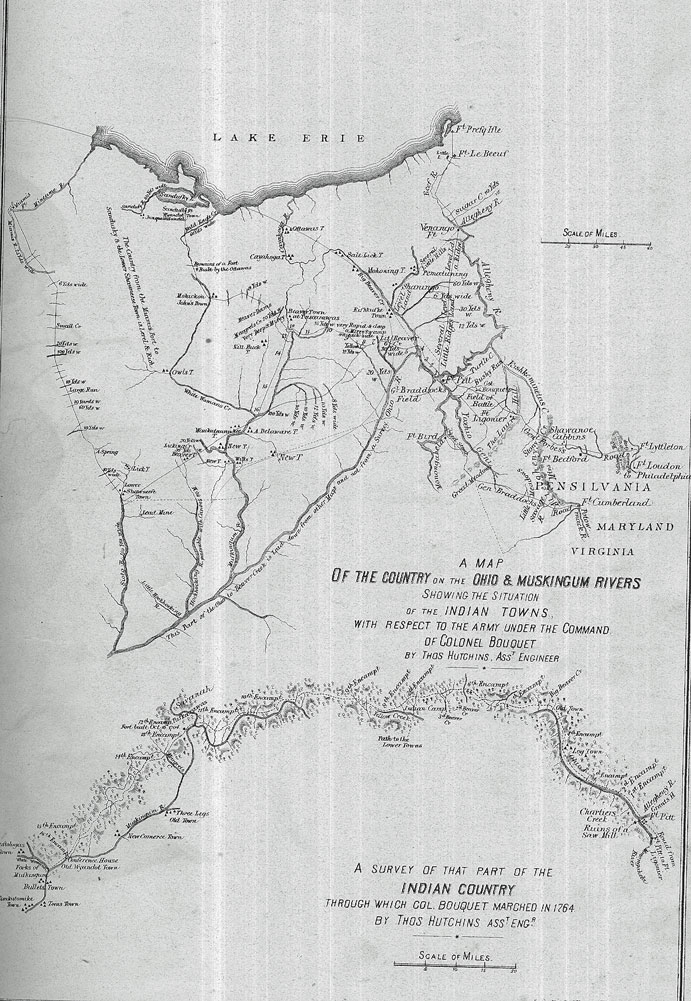
HISTORY OF COLUMBIANA COUNTY, OHIO. BY HORACE MACK. CHAPTER I. VALLEY OF THE MISSISSIPPI. SPANISH DISCOVERIES IN THE NEW WORLD. THE discovery of San Salvador by Columbus was an event which aroused the latent powers of England and France, and stimulated the already awakened energies of Spain to efforts in what promised to be a rich field for conquest and dominion. Though at war among themselves, the possessors of the unexplored land to the westward were doomed to an unequal conflict, which was to result in practical extirpation at the hands of peoples of whose existence they had not dreamed, and who appeared to come up in swarms from the prolific ground or from the heaving. sea. The discovery of the mainland of the Western Continent was reserved for John Cabot, a Venetian, who, under a commission from Henry VII., King of Great Britain, issued May 5, 1496, sailed westward, and after a tedious voyage reached the coast of Labrador. After exploring the country he hoisted the English flag, and in the name of the king took formal possession of the country. " Near the flag of England he planted the banner of the republic of Venice, little thinking, doubtless, that as the centuries rolled on not the flag of proud Albion, but that of a republic, would float from ocean to ocean."* Columbia, as the newly-discovered continent should have been named, became the land of adventure, and the country drained by the Mississippi and its tributaries, since known as the "Valley of the Mississippi," did not long remain unknown to Europeans. Among the rival nations Spain, by the patronage of whose king and queen, Ferdinand and Isabella, the success of Columbus was insured, was the first to obtain, through her adventurous subjects, a knowledge of the existence of the " Father of Waters.;" the first to plant her standard upon its border ; the first to carry it in gloomy triumph to the mouth of the majestic river. Moved by the fabulous tales concerning vast riches hidden in the unexplored regions around the Mexican Gulf, Spain and Portugal sent forth numerous fleets and * Henry B. Peirce, in the History of Tioga, Chemung, and Schuyler Counties, N. Y. L. H. Everts, Philadelphia, 1879. armies on errands of discovery. While the principal efforts of these powers were directed towards the treasures of Mexico and Peru, individual adventurers came forth ; among them was Ponce de Leon, a former companion of Columbus, and ex-governor of Porto Rico. He discovered the peninsula of Florida on Palm Sunday (Paschua Florida), March 27, 1512, while upon an insane expedition in search of the Fountain of Youth, " whose waters, it was said, possessed the property of perpetuating youth beyond the power of time and disease," and which was reputed by tradition among the Indians to be situated in one of the Bahama Islands. De Leon, as the reward for his discovery, was subsequently appointed governor of Florida by Charles V., and landing again upon the inhospitable shores of that country, in an attempt to plant a colony, was driven off by the natives, himself receiving a mortal wound of which he died soon after reaching Cuba. The second adventurer within the limits of Florida was Vasques de Ayllon, who sought to secure numbers of the natives to serve as slaves in the mines of Mexico. In 1520 he landed on the eastern coast of Florida, " where the vessels were anchored in a river, in latitude 32̊ north, in a country called by the natives Chicorea." Enticing many of the natives on board his ships, he treacherously confined them below decks, and set sail for St. Domingo. One of his two vessels was lost ; the other reached its destination, but " the Indians on board remained sullen and gloomy, and, refusing all food, most of them died of famine and melancholy." In a subsequent visit, in 1525, with an outfit which cost him his fortune, having authority from the Emperor of Spain to subdue and govern the country of Chicorea, nearly all his soldiers were entrapped and slaughtered by the natives, who exercised a strategy and duplicity fully equal to his own. Some accounts say that Vasquez himself was slain. In 1528, Pamphilo de Narvaez was appointed governor, with the title of commander-in-chief, over " all the country of Florida from Cape Sable as far as the River of Palms" (probably the Colorado), " in the west of Texas." Narvaez sailed in March, 1528, from Cuba, and entered the bay of Espiritu Santo, or Tampa Bay, with four ships, and landed his forces, consisting of three hundred men and forty-five horses. The - 9 - 10 - HISTORY OF COLUMBIANA COUNTY, OHIO. reputed wealth of the interior was still the spring of action, and deluded by the belief that the country he was about to visit embosomed populous and wealthy cities, such as Mexico, he boldly pushed forward. Perpetrating outrages and cruelties upon the natives as be advanced, such as usually characterized the progress of the armies of Spain, the commander drew upon himself and followers the vindictive hatred of the Indians, whom he forced to serve as guides. These led the army tedious. marches through swamps and thickets, while the land of gold, like an ignis fatuus, remained provokingly distant, while yet alluring. This land, the guides declared, was in what is now Georgia, "between the Alapahaw and Withlacoochy Rivers, east Of Flint River." When finally they reached the place, they found, instead of a great city, a deserted village of "two hundred and forty—huts and sheds," and their visions of rich plunder were dispelled. Their retreat was one of merited hardship and disaster, " through dismal swamps with deep lagoons," until finally in famishing plight they reached the village of Ante,, recently deserted by the Indians, within a day's march of the sea and near the present site of St. Mark's. One-third of the force had perished in the campaign ; the remainder embarked in five vessels, which had been provided with great labor. Storms scattered and wrecked most of the vessels, and "out of the whole number who landed at the bay of Espiritu Santo for this expedition only five escaped, Alvar Nunez Cabexa de Vaca and four of his companions. They were in the other bark that remained after the night storm, and were afterwards cast upon the inhospitable shore; and, as Mr. Irving* observes, a After the most singular and unparalleled hardships, they traversed the northern parts of Florida, crossed the Mississippi, the desert mountainous regions on the confines of Texas and the Rocky Mountains, passing from tribe to tribe of Indians, and often as slaves, until, at the end of several years, they succeeded in reaching the Spanish settlement of Compostella. From thence Alvar Nunez proceeded to Mexico, and ultimately arrived at Lisbon in 1537, nearly ten years after his embarkation with Pamphilo de Narvaez.' " + Nunez and his companions were doubtless the first white men who looked upon the broad expanse of the Mississippi; but from their discovery nothing practical resulted. Despite his harsh experiences and the fate of Narvaez, Nunez encouraged further exploration in Florida, which land he rep- resented as richer than Mexico, and was the chief inciting cause of the hapless campaign of Hernando de Soto. De Soto sailed from Spain, April 6, 1538, for Havana, and on May 12, in the following year, with eight large and three small vessels, and a force of one thousand men, inclusive of three hundred and fifty horsemen, set sail for the bay of Espiritu Santo, where in a fortnight they arrived. By permission from Charles, Emperor of Spain, De Soto had undertaken the conquest of Florida, "at his own risk and expense ;" and the entire army engaged with him were no less than a horde of unscrupulous freebooters. His * Theodore Irving, author of Conquest of Florida. + History of the Discovery and Settlement of the Valley of the Mississippi, by John W. Monette, M.D., 2 vols., Harper Brothers, 1848. march through the country of the Indians was one of exceeding cruelty, unequaled by that of his predecessors, but was not exempt from serious disaster to his own followers. Notwithstanding his great losses in a conflict with the warriors of the native King Tuscaluza, at the ancient town of Mauvile, or Mobile, De Soto .pressed forward, and in March, 1541, reached the eastern bank of the Mississippi. "-At this place," says the Portuguese historian, " the river was half a league from one shore to the other, so that a man standing still could not be seen from the' opposite shore. It was of great depth and wonderful rapidity. It was very muddy, and was always filled with floating trees and timber, carried down by the force of the current." Having crossed the river at a point about thirty miles below the present site of Helena, he made, with his fast lessening army, numerous expeditions towards the north and west in a vain search for gold, and having penetrated to near the present western boundary of Arkansas, in latitude 36̊ north, returned at the approach of winter to the Mississippi. He reached the river at the native town of Capaha, which, it is supposed, was situated about eight miles below the site of Helena. Here, discouraged by his fruitless search for the precious metals and by the prospect of evils to come, he relapsed into melancholy, fell ill of a fever of which he died about the 5th of June, 1542, and was buried in the depths of the magnificent river. Luis de Moscoso, whom De Soto had appointed to command as his successor, led the remnant of the army westward, reached the Red River a little north of the present State of Texas, and in October again turned eastward and gained the Mississippi near the mouth of the Arkansas.- Having constructed rude vessels, the Spaniards embarked upon the former stream July 2, 1543, and after serious conflicts with the savages, who in their light canoes swarmed around them from the eastern shore, in twenty days reached the open sea at the river's mouth. Florida, according to the claims of Spain after the campaign of De Soto, extended from the Gulf of Mexico to the mouth of the St. Lawrence ; but this immense province, now that the dreams of mineral wealth were dissipated, was practically abandoned fora considerable period as unworthy of the Spanish arms. CHAPTER II. FRENCH DISCOVERIES IN THE NEW WORLD. WHILE the Spaniards were making voyages and military excursions to the West Indies, Mexico, and Florida, the French directed their vessels to the coast of the New World, in a more northerly latitude. The Normandy fishermen visited the. Banks of Newfoundland as early as 1504; and four years later a number of the-natives of America were taken to France. Under authority from Francis I., John Verrazzoni, a native of Florence, in 1523 discovered the mainland in the latitude of Wilmington, and thence coasted in a northerly direction until he reached Newfoundland, landing at intervals to traffic with the Indians, who received him in HISTORY OF COLUMBIANA COUNTY, OHIO - 11 friendship. He named the country New France, claiming the same in the name of the king. In the year 1534, Jacques Cartier descended the St. Lawrence, giving the gulf that name which was afterwards extended to the river. On his second voyage, in 1535, he ascended the river to the Island of Orleans and gave the name " Mont Real" to a hill, now the site of Montreal. At what is now Quebec he fell in with the native " King of Canada." In his third voyage he explored the Saguenay country. At this period the French made numerous unsuccessful attempts to plant colonies along the North Atlantic coast of America, continuing their efforts through a number of years, but gained only a temporary lodgment at "Acadie"* and " Cape Breton." Henry Dumont, or De Monts, who had received a grant from Henry IV.,—one of the first of' those European potentates who made prodigal disposition of lands in America which they did not own,—sailed in 1604 with five vessels to search for mines. Attended by a " mixed company," he settled at St. Croix, and it is said that these were at that time the only whites in the present United States north of Florida. He settled Annapolis, + Newfoundland, which is the second oldest city founded by Europeans in the New World. Samuel Champlain in 1608 visited the Island of Orleans, cleared ground, and in July erected a few cabins on the site of Quebec, which proved the foundation of that city. He obtained a monopoly of the fur trade and fisheries, and established a trading-post at the new settlementl Under the auspices of Champlain, the policy of establishing missions was introduced. " Such a policy was congenial to the Catholic Church, and was favored by the conditions of thecharter itself, which recognized the neophyte among the savages as an enfranchised citizen of France."§ To the remote country of the interior the missionaries 'made their advance by the rivers and lakes, those natural highways supplied by the unequaled water-system of this portion of the New World. In 1634 the French Jesuits, Brebeuf and Daniel, journeyed as far as the Straits of St. Mary and Lake Superior, following the Ottawa and French Rivers. Champlain had * Acadia, or Acadie, the name of the peninsula now called Nova Scotia from the time of its settlement by the French in 1604 until its cession to the English in 1713. In the original commission of the King of France, New Brunswick and a part of Maine were included in Cadie, but practically the colony was restricted to the peninsula. The English claimed the territory by right of discovery.—Am. Cyclop. + Annapolis is the capital of Annapolis County, in the province of Nova Scotia. tinder the name of Port Royal it was the capital of the French colony of Acadia, after the conquest of which, by the English in 1710, the name of the town was changed. The capital was removed to Halifax in 1750. ++ Champlain had been many years engaged as a mariner in exploring the northern coasts near the Gulf of St. Lawrence, comprising the provinces now known as Nova Scotia, New Brunswick, and Cape Breton, south of the Gulf of St. Lawrence, which were embraced in a grant made by Henry IV. of France to a company of merchants and others of Rouen, of whom Pontgrave and Chauvin were principal.—See Martin's Louisiana, vol. i. pp. 34 to 45, ed. of 1827. § See Bancroft's History of the United States, vol. iii. pp. 121 and 127. given aid to the Huron and Algonquin tribes in their struggles with the fierce Iroquois, whose " Five Nations" occupied the country south of the St. Lawrence and Lake Erie, and thus drawn upon the French the implacable hostility of that confederacy. In consequence of this the better route to the westward, by the upper St. Lawrence and the great lakes, was practically closed to the Jesuit missionaries. Their route is described as leading " through .a region horrible with forests. . All day long they must wade or handle the oar. At five-and-thirty waterfalls the canoes were carried on the shoulders for leagues through thickest woods and over the roughest regions; fifty times they were dragged through shallows and rapids and over sharpest stones." II Others of the Jesuit fathers followed to the country on the borders of Lake Huron during the seven years succeeding 1640, among whom were Charles Raymbault, Claude Bejart, Isaac Jogues, and Father Bressani. Jogues and Bressani were captured by the Iroquois, and suffered at their hands tortures the most excruciating ; but were ultimately rescued and ransomed by the Dutch on Hudson's River. Jogues returned in 1647, after a visit to France, and sought to conciliate the powerful Iroquois. In this effort he lost his life, and directly following this event the missionary settlements in Canada were assailed by the savages and destroyed. The zeal of the Jesuits would not permit a cessation of their efforts in the new land. Missionaries in greater numbers entered upon the work so fatefully begun, and in a few years brought about friendly relations with their former enemies. In 1667, Father Claude Allouez, while in missionary service among the Chippewas, first learned of a river to the westward, called by the natives " Mesasippi" or Great River. Two years later, Claude Dablon and James Marquette were sent to establish the mission of St. Marie, which formed the oldest settlement by Europeans within the present limits of Michigan. III In 1673, Father. Marquette, who four years previous had resolved upon the discovery of the great river, was chosen with M. Joliet, a trader of Quebec, to effect that purpose. Father Marquette had gained the good-will of the natives, and such was their veneration for the gentle father that for a long time after his death, when their canoes were storm-tossed on Lake Michigan, it is said they " called upon the name of Marquette, and the wind ceased and the waves were still."** Marquette and his companion, , with five other Frenchmen, left Michilimackinac May 13, 1673, coasted along the western shore of Lake Michigan, entered the bay of Puants (now Green Bay), ascended Fox River to the village of the tribe so named,- then the " extreme limit of missionary effort in those western regions, where Allouez had already planted the cross." ++ Having procured Indian guides, they crossed the portage to the Wisconsin, carrying their canoes on their backs, and stood for the first time in the valley of the Mississippi, at a point beyond which no Frenchman had ventured. Aban- II Bancroft's Hist., vol. iii. p. 152. III Letters of Charlevoix.. ++ See John W. Monette's Valley of the Mississippi, vol. i. p. 124. 12 - HISTORY OF COLUMBIANA COUNTY, OHIO. doned by their guides, they floated down the Wisconsin, and after seven days entered the great river June 17, 1673.* One hundred miles below the mouth of the Wisconsin an Indian town near the western shore was discovered, where Marquette announced " the one true God, their Creator, and related how the French governor of Canada had humbled the Iroquois." The savages were rejoiced, caused the party to tarry six days, and suspended from the neck of Marquette the sacred calumet, or " peace-pipe," as a "safeguard among strange tribes." Floating down the river, they passed the Missouri, or Pekitanoni, and the Ohio, and continued their voyage down to latitude 33̊ north, a considerable distance below De Soto's point of crossing one hundred and thirty-two years before. Father Marquette and his party returned to the lakes by way of the Illinois River. The task of completing the exploration of the great river was undertaken by the ambitious, hardy, and enterprising Monsieur la Salle, a native of Rouen, in Normandy. The hope of reaching the South Sea and China by means of some of the western tributaries of the Mississippi, as suggested by Marquette, was still entertained in Europe, and was shared by La Salle. His plan to push French settlements westward and provide them with proper defenses was favorably entertained by the king. He was appointed to the command of Fort Cataracoui, afterwards called Frontenac, on the site now occupied by the city of Kingston, on Lake Ontario. On the 18th of November, 1678, he set out from the fort in a bark of ten tons, and, reaching the head of Ontario, spent the winter in making further preparation for his expedition. Unable to ascend the falls of Niagara with his vessel, he built upon Lake Erie the " Griffin," of sixty tons burden, which was finished Aug. 7, 1679, and was the first sailing-vessel upon that lake. Three monks were of the company, one of whom was " Father Louis Hennepin, a Franciscan friar, a man full of ambition for discoveries and fame ; daring, hardy, energetic, vain, and self-exaggerating almost to madness." The route of the expedition led through Lakes Huron and Michigan to Green Bay, where they arrived in October. From that place La Salle sent the " Griffin" upon a return voyage, richly laden with furs. The vessel was wrecked and the cargo lost ; but La Salle, impatient for the " Griffin's" re-appearance, did not learn her fate until the ensuing January. Meantime he had proceeded southward, and passing around the lake to the river St. Joseph, secured consent of the Miamis for the erection of a stockade-fort and trading-post at the mouth of that river. He passed over to the Illinois, and descended that river to the broad portion of it called Lake Peoria, where he built a fort which, because of despondency occasioned by signs of mutiny among his men, he named " Creve Coeur," or Broken Heart. The Indians became suspicious of the designs of La Salle, but fortunately serious trouble was averted. In February, 1680, before his return to Fort Frontenac, he arranged an expedition, under the lead of Father Hennepin, to explore * Monette's Hist., vol. i. p. 125. the upper Mississippi. After a delay of ten days, occasioned by floating ice in that river, Hennepin ascended to the " Falls of St. Anthony," so called by him in honor of his patron saint, St. Anthony, of Padua. His party spent several weeks exploring the country above the falls, " but never reached the real sources of the great river, as Hennepin falsely affirmed." + In the latter part of the summer of 1680, Hennepin again entered the Mississippi through the Wisconsin, and proceeded to the mouth of the Arkansas, and from that point returned without reaching the mouth of the great river. La Salle had named the Illinois St. Louis," and the country traversed by it " Louisiana," both in honor of the King of France. Desiring to complete the work of exploration, he started from Fort Creve Coeur in 1682, and on the 2d of February entered the Mississippi, determined to carry his investigations to its union with the sea. A few days were spent at the mouth of the Missouri, which he named "St. Philip," and other days at the mouth of the Ohio, to arrange for trade with the Indians, and at Chick-ash Bluffs for a like purpose, where he obtained permission to build a fort. This post was called " Fort Prud homme," after one who was left in command with a small garrison. He tarried at the mouth of the Arkansas, was well received by the Tensas Indians, whose village was situated, it is believed, upon the banks of what is now known as "Lake Providence," and reached Red River on the 27th of March. After a few days' delay he pursued his journey, and reached the goal of his endeavors—the confluence of the great river with the Gulf--on the 7th of April. After a few days spent in making discoveries along the coast of the Gulf, he "planted the arms of France, erected the cross, and calling the country ' Louisiana,' he closed the ceremony with a display of the solemn and imposing rites of the Catholic Church. ++ Two years later the explorations of La Salle were extended to the country of Texas.§ By virtue of these discoveries, France made claim to all the territory drained by the " Great River" and its tributaries, including the country whose waters descend to the Ohio on the south and to Lake. Erie on the north. The undefined limits of the provinces in America claimed severally by the great powers, Spain, France, and England, and the greed for territorial extension, manifested most strongly on the part of the last named, gave rise to serious struggles, both diplomatic and military, covering the period from 1690 to 1821, when, by lot of war and by purchase, a power younger than either—the United States--acquired the largest part of her present magnificent domain, including the " Mississippi Valley." The treaty by which France ceded "Louisiana," west of the Mississippi, was signed April 30, 1803. + Monette's Valley of the Mississippi, vol. i. p. 139. ++ See Martin's History of Louisiana, vol. i. pp. 100, 101. § It has been claimed that La Salle, in the year 1670, proceeding from Lake Erie, reached the Ohio at the Forks, where now is the city of Pittsburgh, and from thence floated down the river to the Falls. The statement, however, is disbelieved by historians generally. HISTORY OF COLUMBIANA COUNTY, OHIO - 13 CHAPTER III. INDIAN OCCUPANCY. WHEN white men first became acquainted with the region lying immediately south of Lake Erie, a tribe of Indians called Eries were in actual possession, and their claims doubtless extended over all of Northeastern Ohio and Western New York. They were brave, fearless, and disposed to boast of their strength and prowess, and were at the maximum in numbers and power at the period of the simultaneous advance of Champlain upon the St. Lawrence and of Hudson upon the North River" in 1608. Tradition asserts that, anticipating the union of the five tribes in, the State of New York, whose power in that event they feared would be concentrated against them, under plea of a friendly contest they challenged these tribes to a trial of skill in wrestling, racing, and other Indian games. Equal numbers of their most athletic young men were chosen by each side, who met on favorable ground and struggled for the mastery in a manner worthy of the best days of Greece and Rome. In each particular the representatives of the five tribes were victorious, which only stimulated the Eries to prevent the combination, and to this end they planned the destruction of the tribes in, detail by a sudden onslaught. The eastern Indians were warned of the design, quickly concentrated their warriors, and met the advancing Eries not far from what is known as Honeoye Falls, in the county of Monroe. At this place the Eries are said to have fallen almost to a man, after one of the, most sanguinary and hotly contested conflicts known to Indian history. The destruction of the Eries is by some writers alleged to have taken place in the year 1656.* The tradition above narrated relates to a period anterior to 1600, the probable date of the famous league of the Five Nations, " as it was a powerful organization at the date of Dutch occupancy in 1609." The Iroquois, it is alleged, were at one time in subjection to the Adirondacks, against whom they arose unsuccessfully, and were obliged to retire from the north side of the St. Lawrence to the Seneca River. The league, from its formation until 1712, consisted of five nations,— Onondagas, Oneidas, Mohawks, Cayugas, and Senecas,—when the organization became known as the " Six Nations" by the admission in that year of the Tuscaroras, " shirt-wearing people," who had been driven from the western part of North Carolina. Rising in their combined power and burning for revenge and conquest, they turned against and utterly annihilated the Adirondacks, and " conquered the Hurons, the Eries, the Andastez, the Chauanons, the Illinois, the Miamies, the Algonquins, the Delawares, the Shawanese, the Susquehannocks, the Nanticokes, the Unamis, the Minsi, and even the Carnise Indians, in their sea-girt home upon Long Island, found no protection against their attacks. The name of the Iroquois had become a terror to all the Indian nations." Before 1720, the Ohio above the mouth of the Wabash was known as the "River of the Iroquois;" which was * See Early Notices of the Indians of Ohio, pamphlet, by M. F. Forbes, 1879. often called the Hoio by the Indians, and it is not definitely known whether the conquering Iroquois, prior to that period, actually occupied that part of the country of the Eries which is now a part of Ohio, situated between this warlike confederacy on the east and the equally warlike Shawanese on the west, who occupied the valleys of the Scioto and Miami. The intervening country is said to have been uninhabited except by bands of Shawanees—Shawnees—or war-parties of the Iroquois and Miamis. The Wyandots + are said to have made a treaty with the Five Nations about the year 1694, and to have "gradually extended and moved into what is now Ohio, the Delawares afterwards coming in from the east, the Miamis from the west, and the Shawnees from the south." In the early part of the eighteenth century a portion of the Five Nations, mostly Senecas, called Mingoes by the Pennsylvanians, froth the Delaware term Mengwe, occupied the northern part of Ohio. ++ The century opened auspiciously for the French by the conclusion of a treaty at Montreal in the summer of the year 1700, between the Iroquois, on the one side, and the French and Western Indians, on the other. " A written treaty was made, to which each nation placed for itself a symbol,---the Senecas and Onondagas drew a spider ; the Cayugas, a calumet ; the Oneidas, a forked stick ; and the Mohawks, a bear." It was agreed " that war should cease between the French allies and the Sioux; that peace should reach beyond the Mississippi." § This bond of fealty and good-will was strengthened by the admission to the confederacy of the Tuscaroras, who had suffered wrongs in North Carolina at the hands of the English. During the period extending from 1754 to the final treaty of peace between France and England in 1763, most of the Indian tribes from Lake Champlain to the Mississippi "were engaged as allies and auxiliaries to the French arms." At the latter period " some bands of the Six Nations dwelt on the sources of the Ohio, south of Lake Erie, and others as far west as Cuyahoga River, on Lake Erie." ++ The Iroquois claimed by right of conquest " the whole of the country from the Atlantic to the Mississippi, and from the lakes to. Carolina." III Among the treaties made by the colonies with this powerful confederacy was one signed at Lancaster, Pennsylvania, in June, 1744, whose grants of territory were very indefinite. By its terms were conveyed all the lands within the bounds of Virginia ; but + "Mr. Fermi, an old citizen of Fairfield township, tells me that in early times the Wyandots encamped near where Salem now stands, and being in a very destitute condition, the whites gathered up provisions and went to their relief, and in return for their kindness received as a present from the Indians a wampum or bead-belt (being the highest token of gratitude and friendship), which belt was afterwards kept and preserved in the family of old William Heald, who was one of the first government surveyors in our county, and towards the close of his life moved to Iowa, and died at over one hundred and two years of age."--H. K. Greyg's Address before the Columbiana Pioneer Society, September, 1873 ++ See pamphlet, 1879, "Some Early Notices of the Indians of Ohio," Archives of the Western Reserve Hist. Soc., Cleveland. § Bancroft's Hist. of the U. S., vol. iii. p. 194. Il Monette's Valley of the Mississippi, vol. i. p. 323. III Cadwallader Colden. 14 - HISTORY OF COLUMBIANA COUNTY, OHIO the Indians subsequently claimed that they had been deceived, and " did not intend to cede any lands west of the mountains." * However valid or weak the claim of England to lands on the Ohio, it is evident that between French discovery and British diplomacy the Indian. claims were of small significance. The French and Indians resisted the encroachments of the English upon the territory north and west of the Alleghany and Ohio Rivers, and until the extinguishment of French claims by the treaty of Paris, in 1763, the din of arms continued, and that portion of the New World was a scene of war and massacre, the result of savage warfare instigated by rival Christian nations. The uprising of Pontiac, an Ottawa chief, prolonged the strife until the adoption of the treaty of " German Flats," in November, 1764, by which the Six Nations ceded large tracts of land to New York and Pennsylvania. The tide of westward emigration received a new impetus; .yet, notwithstanding the Indian title was not extinguished to much of the territory occupied by the settlers, the Indians maintained comparative quiet for ten years. The treaty of Lancaster, 1744, which the Indians had been induced to sign, after partaking freely of whisky-punch, " bumbo," and wine, duly administered by the honorable commissioners from Virginia, Pennsylvania, and Maryland, was still vehemently repudiated by the savages, who were growing more and more restless, and ready to rise upon any fresh provocation. Sufficient incentive' to armed hostility was furnished directly in the causes which led to LORD DUNMORE'S WAR. Near the end of April, 1774, a party of land-jobbers gathered at Wheeling, Va., pretending to apprehend an attack from the Indians. Capt. Cresap, who was in command at Fort Fincastle, learning that two Indians, with their families, were coming down the Ohio, a few miles above Wheeling, proposed to slay them. Devoid of any spark of humanity, and regardless of the consequences to the settlements which the act would inevitably produce, of which be was duly warned by Col. Zane, the bloody design was fully carried out by Cresap, who shot the Indians in * " The province of Virginia invariably took the lead in all movements for the occupancy of the Western lands. As early as 1774, two commissioners from Virginia, Col. Thomas Lee and Col. William Beverly, with others from Pennsylvania and Maryland, convened a portion of the Six Nations at Lancaster, Pa., for the purpose of treating with them for the sale and relinquishment of large bodies of land extending west of the settlements in the three provinces, from the Susquehanna to the Potomac. After a liberal use of whisky-punch, `gumbo,' and wine, of which the Indians partook freely, the treaty was duly read and signed by the parties respectively. The amount paid the Indians for signing this treaty was two hundred and twenty pounds on the part of Maryland, and two hundred pounds on the part of Virginia, both in Pennsylvania currency, besides sundry presents, and abundance of whisky-punch and ‘bumbo.'" At subsequent treaties, held at Logstown, Winchester, and other places for the purpose, the Indians "indignantly refused to ratify the treaty of Lancaster." . . . "In all these treaties, whether ratified or rejected, the Virginians appear to have been determined to coerce a relinquishment of the Indian lands, either by fair means or foul, and no effort of negotiation or intrigue was omitted to accomplish this purpose."—See Monette's Hist. of the Mississippi Valley, pp. 348, 349. their canoes, a few miles above Wheeling. This unprovoked and cowardly crime was followed by another at the mouth of Captina Creek, below Wheeling, where Cresap and his followers shot a number of Indians in cold blood, one man receiving in turn a severe wound. A few days afterwards, Daniel Greathouse, claiming to fear mischief from a number of Indians who were encamped near the mouth of Yellow Creek, collected a party of thirty-two men, and proceeded to " Baker's Bottom," on the east side of the Ohio, and opposite the Indian encampment. Greathouse crossed the river alone,—a spy in friendly guise,—but was warned by an Indian woman to return, because the warriors were drinking, were exasperated at the recent murders, and might do him some injury. The force of savages being too great, a plot was laid by which many of them were decoyed across the river and made helplessly drunk on whisky supplied by one Baker. While in this condition they were wantonly murdered by Greathouse, aided by a few others of his bloody gang. The f ndly squaw, Vim I warned Greathouse of his danger, was not spared. Those of the conspirators who calmly viewe the horrid work were equally guilty with the principals for permitting its consummation. Among the victims in the murders at Captina and Yellow Creeks were the kin of the noble native chieftain Logan, of the Cayuga tribe of the Iroquois. From' an influential advocate for peace, the slaughter of his &tire family converted Logan into a determined enemy of the whites in Virginia. A timely message from the authorities of Pennsylvania, condemning the outrages and reminding the Indians that the wrongs had not been committed by the dwellers in that province, turned the fury of the onset chiefly against the Virginia settlements. + The civil authorities rendered no redress for Indian grievances, but rather encouraged the lawlessness of the whites by their indifference. Numerous other acts of fiendishness than those related mark the sad history of that period, including the killing of " Bald Eagle," who had long been a friend to the pale-face. While alone in the Woods, near the Monongahela, he was murdered by three white men, who afterwards" placed the lifeless body of their victim in a sitting posture in his canoe, and sent it adrift down the stream." ++ The Shawanese on the Scioto, as principals in the war, aroused other tribes on the north and, west, and began the conflict by murdering all whites found within their territory. Lord Dunmore, Governor of the Province of Virginia, took steps to protect the frontier settlements and chastise the hostile Indians. The ensuing war, called " Dunmore's War," lasted until Jan. 7, 1775. " The Indian declaration of war' was made by Logan on the 21st of July, 1774, in company with a party of eight warriors. Having advanced into the settlements on the upper Monongahela, and having killed one man and taken two prisoners on the 12th of July, he returned on the 21st and left at the house of William Robinson, whose family he had murdered, the war-club,' to which was attached a note, written by a white prisoner who had been + See Gordon's History of Pennsylvania, p. 475. ++ Monette's Valley of the Mississippi, vol. i. p. 372. HISTORY OF COLUMBIANA COUNTY, OHIO - 15 adopted into Logan's family, in the following words, viz.: "'CAPTAIN CRESAP,-Why did you kill my people on Yellow Creek ? The white people killed my kin at Conestago a great while ago, and I thought nothing of that. But you have killed my kin again on Yellow Creek, and took my cousin prisoner. Then I thought I must kill too, and I have been three times to war since; but the Indians are not angry, it is only myself. July 21, 1774. CAPTAIN JOHN LOGAN." " * The first expedition, under Gen. McDonald, was directed against the Wappatomica towns on the Muskingum, sixteen miles below the junction of the Tuscarawas and Walhonding branches, but was attended with small success. The route pursued to reach the towns was by the Ohio to Captina Creek, and thence westward. The most sanguinary battle of the war took place at the mouth of the Kanawha, Oct. 10, 1774. The Virginians engaged. were twelve hundred in number, commanded by Gen. Andrew Lewis, and had recently made a difficult march through the wilderness down the valley of the Kanawha. The flower of the Indian tribes were engaged under Cornstalk, the great Shawanese chief, aided by his son Ellinipsico ; Red Hawk, a Delaware; Chiyawee, a Wyandot ; and Logan, a Cayuga chief. + The slaughter was terrible, but resulted in a victory for the Virginians. A second division, under Lord Dunmore, which was not engaged in this battle, proceeded down the Ohio to the mouth of the Hocking, up that river to the falls, near the present town of Athens, and thence westward to the Scioto, and established its camp "in the margin of the Piqua plains, near Sippoo Creek." At this place was perfected a treaty of peace by which the Indians acknowledged the Ohio River as the boundary between the white man's territory and the Indian hunting-grounds. ++ The great chief Logan was unappeased and did not attend the council ; but subsequently uttered, in the presence of Gen. Gibson, the words which have given him an undying name in history, and which, it is claimed, have received a more polished dress since they escaped the lips of the swarthy orator. CHAPTER IV. BOUQUET'S EXPEDITION—INDIAN TRAILS— INDIAN TOWNS. IN 1754, a detachment of English, forty in number, under Lieut. Ward, erected a fortification at the junction of the Alleghany and Monongahela Rivers, known as the " Forks" of the Ohio, now the site of Pittsburgh. The post was captured, in April of that year, by a strong force of French and Indians under Contrecoeur, who erected a fortification which he called " Fort Duquesne." On the 28th of May, Col. Washington surprised and captured without resistance a detachment of fifty men; under M. Jumonville, whereupon, anticipating an attack from a larger force, he fell back to the Great Meadows, * American Pioneer, vol. i. p. 18, or Monette's Valley of the Mississippi, vol. i. p. 373. + Butler's Kentucky, p. 61. ++ Monette's Valley of the Mississippi, vol. i. p. 385. where he erected a defense afterwards known as " Fort Necessity." . The fort was invested by a force of nine hundred French and Indians, July 3, and capitulated after a brave defense. One year afterwards, July 9, 1755, Gen. Braddock was slain and his army routed in a campaign undertaken for the reduction of Fort Duquesne. The scene of the conflict, called " Braddock's Field," was upon the Monongahela, ten miles above its junction with the Ohio. Another army was organized in 1758 for the reduction of the fort, upon whose near approach the French, " having dismantled the works, sot fire to the buildings at night, and departed down the Ohio, in a blaze of light; to join the French troops on the Mississippi." The Indian. tribes were not parties to the treaty between England and France made in February, 1763 ; but continued to menace and assail the settlements, and began the " Pontiac War" in the same year. Having been sorely defeated at "Bushy Run," near Fort Pitt, by Col. Bouquet, August 5, the Indians retreated north of the Ohio, deserted their former towns, all the country between Presque Isle and Sandusky, and all of Eastern Ohio. Determined to bring the Indians to submission, Gen. Gage planned two expeditions, of whose operations the following is a condensed narrative.§ Delays prevented the advance of the columns until the fall of 1764: A body of troops under Col. Bradstreet was sent against the Wyandots, Ottawas, Chippewas, and other nations living upon or near the lakes; and another corps, under the command of Colonel Bouquet, should attack the Delawares, Shawanese, Mingoes, Mohickous, and other nations between the Ohio and the lakes. Col. Bradstreet was to proceed to Detroit, Michilimackinac, and other places, return to Sandusky, and there remain to prevent assistance being sent by the Western Indians to their beleagured brethren in Ohio. Col. Bouquet with his force of regular and provincial troops, amounting to about fifteen hundred men, after many delays, marched from-Fort Pitt on the 3d of October. On October 5 the army reached Logstown, Pa. (situated seventeen miles and a half, fifty-seven perches, by the path from. Fort Pitt), a former trading-place of the French and English, which the Shawa taw and Delawares had abandoned in the year 1750. On the 6th they came again to the Ohio, about three miles from Logstown, and continuing the march a half-mile farther, passed Big Beaver Creek. About a mile below its confluence with the Ohio stood formerly a large town, on a steep bank, built by the French of square logs, with stone chimneys, for some of the Shawanese, Delaware, and Mingo tribes, who abandoned it in 1758, when the French deserted Fort Duquesne. Near the fording of Beaver Creek also stood about seven houses, which were. deserted and destroyed by-the Indians after their defeat at Bushy Run. . . . About two miles before the army came to Beaver Creek, one of the people who had been made prisoner by six Delawares about a week before, near Fort Bedford, having made his escape from them, came and informed the colonel that these Indians had the day before fallen in with the army, but kept themselves concealed, being surprised at our numbers. Two miles beyond Beaver Creek, by two small springs, was seen the skull of a child that had been fixed on a pole by the Indians. The tracks' of fifteen Indians were this day discovered. The camp No. 5 is seven miles, one quarter, and fifty-seven perches from Big Beaver Creek; the whole march of this day being about twelve mites. Sunday, 7th October, passing a high ridge, they had a fine prospect of an extensive country to the right, which in general appeared level, with abundance of tall timber. The camp, No. 6, lies at the foot of a steep descent, in a rich valley, on a stony ground, three sides thereof § Bouquet's Expedition against the Ohio Indians, in 1764, with map, and preface by Francis Parkman. Ohio Valley Historical Series, Cincinnati, 1868. 16 - HISTORY OF COLUMBIANA COUNTY, OHIO surrounded by a hollow, and on the fourth side a small hill, which was occupied by a detached guard. This day's march was six Miles, sixty-five perches. Monday, 8th October, the army crossed Little Beaver Creek, and one of its small branches. This creek is eight perches wide, with a good ford, the country about it interspersed with hills, rivulets, and rich valleys, like that described above. Camp No. 7 lies by a small run on the side of a hill, commanding the ground about it and is distant eleven miles, one quarter, and forty-nine perches from the last encampment. Tuesday, October 9th. In this day's march the path divided into two branches, that to the southwest leading to the lower, towns upon the Muskingham. In the forks of the path stand several trees painted by the Indians in a hieroglyphic manner, denoting the number of wars in which they have been engaged, and the particulars of their success in prisoners and scalps. The camp, No. 8, lies on a run and level piece of ground; with Yellow Creek close on the left, and a rising ground near the rear of the right face. The path after the army left the forks was so brushy and entangled that they were obliged to cut all the way before them, and also to lay several bridges, in order to make it passable for the horses, so that this day they proceeded only five miles, three quarters, and seventy perches. Wednesday, 10th, marched one mile with Yellow Creek on the left at a small distance all the way, and crossed it at a good ford fifty feet wide; proceeding, [passed] an alternate succession of small hills and rich vales, finely watered with rivulets, to camp No. 9, seven miles and sixty perches in the whole. On the 11th the army crossed a branch of the Muskingham, and on the 13th the Nemenshelas, a little above where it empties into that branch of the Muskingham,--and another tributary of that branch, and passed on to the main branch of the Muskingham, where they encamped, a short distance from Tuscarawas. Two messengers who had been dispatched from Fort Pitt with letters to Col. Bradstreet were made prisoners by the Delawares, but were released when the arrival of the army became known, and ordered by their captors to inform Col. Bouquet " that the head men of the Delawares and Shawanese were cowing as soon as possible to treat of peace with him." Col. Bouquet, trusting nothing to their protestations, made safe arrangements for if meeting with the Indians at some distance from the camp on the following day, October 15th. Several large bodies of Indians were within a few miles of the camp, who were represented at the meeting by Kiyashuta, chief of the Senecas, and fifteen warriors ; Custaloga, chief of the Wolf tribe, and Beaver, chief of the Turkey tribe- of the Delawares, and twenty warriors ; Keissinautchtha, a chief of the Shawanese, and six warriors. The firmness of Col. Bouquet, backed as he was by a strong force, and, what was quite as influential, the prestige of victory achieved at Bushy Run, brought the Indians to accord all that he demanded. " I give you," said he, " twelve days from this date to deliver into my hands at Wakatamake all the prisoners in your possession, without any exception,—Englishmen, Frenchmen, women, and children, whether adopted into your tribes, married, or living amongst you under any denomination and pretense whatsoever,—together with all negroes. And you are to furnish said prisoners with clothing and provisions, and horses to carry them to Fort Pitt. When you have fully complied with these conditions, you shall then know on what terms you may obtain the peace you sue for." The Indians acceded to the terms, and by the 9th of November most of the prisoners had arrived, two hundred and six in number. Of these were—Pennsylvanians, forty-nine males and sixty-seven females and children ; Virginians, thirty-two males and fifty-eight females and children. The scene which followed the arrival of the prisoners has few equals in the world's history, and is described in the subjoined account : " In the camp were to be seen fathers and mothers recognizing and clasping their once-lost babes, husbands hanging around the necks of their newly-recovered wives, sisters and brothers unexpectedly meeting together after long separation, scarce able to speak the same language, or for some time to be sure that they were children of the, same parents ! In all these interviews joy and rapture inexpressible were seen, while. feelings of very different nature were painted in the looks of others,—flying from place to place in eager inquiries after relatives not found ; trembling to receive an answer to their questions'; distracted with doubts, hopes, and fears on obtaining no account of those they sought for, or stiffened into living monuments of horror-and woe on learning theirppy fate ! " The Indians too, as if wholly getting their usual savageness, bore a capital part in heightening this most affecting scene. They delivered up their beloved captives with the utmost reluctance, shed torrents of tears over them, recommending them to the care and protection of the commanding officer. Their regard to them continued all the time they remained in camp. They visited them from day to day, and brought them what corn, skins, horses, and other matters they had bestowed on them while in their families, accompanied with other presents and all the marks of the most sincere and tender affection. Nay, they did not stop here, but, when the army marched, some of the Indians solicited and obtained leave to accompany their former captives all the way to Fort Pitt, and employed themselves in hunting and bringing provisions for them on the road. A young Mingo carried this still further, and gave an instance of love which would make a figure even in romance. A young woman of Virginia was among the captives, for whom he had formed so strong an attachment as to call her his wife. Against all remonstrances and warnings of the imminent danger to which he exposed himself by approaching the frontiers, he persisted in following her at the risk of being killed by the surviving relations of many unfortunate persons who had been captured or scalped by those of his nation." * INDIAN TRAILS AND INDIAN TOWNS. + The following trails led from Fort Pitt to Indian towns north of the Ohio River FIRST ROUTE, ABOUT N.N.W. |
|
Miles |
Miles |
From Fort Pitt to Kushkuskiestown, Big Beaver Creek Up the east branch of Beaver Creek to Shaningo Up the east branch of Beaver Creek to Pematuning To Mohoning, on the west branch of Beaver Creek Up the branch Salt Lick To Cuyahoga River To Ottawas town, on Cayahoga |
15 12 32 10 32 10 |
45 60 72 104
114
146
156 |
|
* See Bouquet's Expedition, Ohio Hist. Series. + See appendix to Bouquet's Expedition, Ohio Mist. Series. HISTORY OF COLUMBIANA COUNTY, OHIO - 17 SECOND ROUTE, W.N.W. |
From Fort Pitt to the mouth of Big Beaver Creek To Tuscarawas To Mohiekon, John's town To Junundat, or Wyandot town To Sandusky To Junqueindundeh, on Sandusky River |
91 50 46 4 24 |
25 116 166 212 216 240 |
THE THIRD ROUTE led west southwest from Fort Pitt. |
||
FOURTH ROUTE (in part). |
||
By water from Fort Pitt to the mouth of Big Beaver Creek To the mouth of Little Beaver Creek To the mouth of Yellow Creek |
12 10 |
27 39 49 |
Wyandots, near Lake Erie, warriors Miamis, on Miami River, falling into Lake Erie warriors Delawares—Les Loupe— on the Ohio, warriors Skawanese, on the Scioto River, warrior Total number of warriors |
300 350 600 500 1750 |
|
CHAPTER V. LAND-TITLES. Colonial Charters—Indian Treaties—Government Grants. COLONIAL GRANTS. THE conflicting claims of European nations to lands in America were succeeded by those of rival companies, to whom grants had been issued by one or other of the rival powers. Some of the early patents issued by Great Britain were, by reason of carelessness or favoritism, made to " overlap," giving rise to controversies which lasted until the year 1786. The earliest grant for lands on this continent was probably that in 1603 to Henry De Monts—or Dumont—by Henry IV., King of France, covering all the territory from sea to sea, lying between the parallels of 40̊ and 46̊ north latitude. Little claim seems to have been made under this patent. The first English patent was issued by. James I., in 1606, to the-London and Plymouth Companies, the former receiving a grant for "South Virginia, extending from the thirty-fourth to the fortieth degree of north latitude, and from the Atlantic on the east to the South Sea on the west," and the latter receiving " North Virginia or New England." The Plymouth Company was incorporated Nov. 3, 1620, as " The Great Council of Plymouth," and received a grant covering all of New England in America lying between the fortieth and forty-eighth parallels, north latitude, and extending from sea to sea, excepting lands "actually possessed or inhabited by any other Christian prince or state." Of this grant the Massachusetts Colony purchased, in 1628, a part whose southern boundary was afterwards settled to be the forty-second parallel of north latitude. In 1681, Charles II., of England, by letters patent granted 3 to William Penn, his heirs and assigns, all that tract of land in America bounded " on the east by the Delaware River, on the north by the beginning of the forty-third degree of northerly latitude, on the south by a circle drawn twelve miles distant from New Castle town, northward and westward to the beginning of the fortieth degree of north latitude; thence by the beginning of the said fortieth degree of northerly latitude to extend westward through five degrees of longitude, to be reckoned from the said easterly bounds." This grant covered a part of the previous grant to the Virginia colony on the south, and caused protracted lawsuits, and surveys which finally ended in compromise. It also trespassed upon the territory previously granted to Connecticut,—to the extent of one degree in width throughout the length of the present State of Pennsylvania,—and the conflicting grants of two colonies caused agitations, not unmixed with riot and bloodshed, lasting for more than a century. In 1754 a congress composed of deputies from the British colonies north of Virginia, held at Albany by direction of the Lords of Trade and Plantations of England, declared " the ancient colonies of Massachusetts Bay and Connecticut were by their respective charters made to extend to the South Sea."* The territory lying north and west of the Ohio was claimed partly by the States of Massachusetts, Connecticut, New York, and Virginia. The claims were based on the indefinite royal charters, with the additional claim, on the part of Virginia, of title by conquest. For the purpose of adjusting amicably the several claims, the four States named, with others of the old colonies, ceded their interests in .the territory to the Federal government. Two reservations were made. One was made by Connecticut to compensate for lands lost under the charter to Pennsylvania, and embraced "that region of the present State of Ohio lying north of latitude 41̊, and west of the Pennsylvania line. It was bounded on the north by Lake Erie, and was about one hundred and twenty miles in length from east to west, and its greatest breadth from north to south was about sixty-eight miles. The area comprised, by estimate, three millions of acres, and was known as the Connecticut Reserve.'” + Virginia reserved the lands lying between the Scioto and Little Miami, to be appropriated to the liquidation of the claims of her Revolutionary soldiers. This reservation was known as the " Virginia Military District." In addition, Congress reserved or appropriated lands on the east side of the Scioto, known as the "United States Military District," for the payment of claims of Revolutionary soldiers upon the Federal government. New York made the first cession, March 1, 1780 ; Virginia, April 23, 1784 ; Massachusetts, April 19, 1785 ; Connecticut, Sept. 13, 1786. Commissioners from New York and Massachusetts met in convention at Hartford in December, 1786, and awarded to Massachusetts six million acres in the western part of New York, the latter retaining the jurisdiction. Thus the claims * H. B. Peirce, in Hist. of Tioga, Chemung, Tompkins, and Schuyler Counties, New York. L. H. Everts, Phila., 1879. + Monette's Hist. of the Mississippi Valley, pp. 236, 237. 18 - HISTORY OF COLUMBIANA COUNTY, OHIO. of the individual States to lands north of the Ohio were fully extinguished, other claims adjusted, and the way prepared for the erection of the " Northwestern Territory." INDIAN TREATIES. The first line established between the Indian and English lands, termed the " line of property," was agreed upon at Fort Stanwix, on the Mohawk River, in 1768. This agreement was made by Sir William Johnson, superintendent of Indian affairs in America, with the Iroquois on behalf of themselves and their dependent nations, the Shawanese, Delawares, Mingoes of Ohio, and other tribes. This line began where the. Cherokee or Hogohee River, then so called, emptied into the Ohio* River, and "running thence upwards along the south side of the said river to Kittaning, which is above Fort Pitt ; from thence by a direct line to the nearest fork of the west branch of the Susquehanna ; thence through the Alleghany Mountains, along the south side of the west branch until it comes opposite the mouth of a creek called Tiadaghton ; thence across the west branch along the south side of that creek and along the north side of Burnett's Hills to a creek called Awandae ;I thence down the same to the east branch of the Susquehanna, and across the same and up the east side of that river to Oswegy ; from thence east to Delawar River, and up that river to opposite where Tianaderha falls into Susquehanna ; thence to. Tianaderha, and up the west side of the west branch to the head thereof; and thence by a direct line to Canada Creek, where it empties into the Wood Creek at the west of the carrying-place beyond Fort Stanwix."§ In this agreement the lands east of the described boundary were recognized as the property of the whites ; all west thereof as the exclusive property of the Indians. The boundary described was repudiated by the Chickasas and Cherokees south of the Ohio, in the present State of Kentucky, who denied the authority of the " Six Nations" to make the cession. Their protest was respected, and subsequent treaties made to confirm the English titles. By the treaty of Fort Stanwix, in New York, concluded Oct. 22, 1784, the Indians ceded a large part of their possessions in the western part of that State, and on the 21st day of the following January the Treaty of Fort McIntosh, in the western part of Pennsylvania (where is now the town of Beaver), was concluded and signed. The treaty was effected by George Rogers Clark, Richard Butler, and Arthur Lee, commissioners on the part of the United States, and was subscribed by the Wyandots, Delawares, Ottawas, and Chippewas, who then occupied the country near Lake Erie, west of the Cuyahoga River. By the terms of the treaty the Indians relinquished all the, territory in the present State of Ohio lying east of an irregular line, extending from Lake Erie to the Ohio River, which afterwards became the western boundary of the county of Wash ington . I I The Indians of New York were dissatisfied with the last treaty of Fort Stanwix, and the Northwestern Indians no less with that of Fort McIntosh. England had reluctantly * Below the mouth of the Scioto. + Towanda. ++ Owego, N. Y. § Doc. list. N. Y., vol. i. p. 587. II See chapter on Organization of Columbiana County. surrendered the country between the lakes and the Ohio, and through her agents and traders continually urged the Indians to claim to that river as the rightful limit of their lands, fixed by the treaty with Sir William Johnson, in 1768. III Thus pressed to renewed negotiations, Arthur St. Clair, governor of the Northwestern Territory, as commissioner, secured a treaty at Fort Harmar, signed Jan. 9, 1789, by which all the " Six Nations," except the Mohawks, reaffirmed the, treaty of Fort Stanwix, and the six Northwestern tribes, Wyandots, Delawares, Ottawas, Chippewas, Pottawatamies, and Sacks, recognized both treaties, and the boundaries established by them respectively. The Shawanese had made, Jan. 31, 1786, a treaty, confirming a prior treaty of Jan. 14, 1784, and reserving as their hunting-grounds " the territory lying west of the Great Miami, and north of a line drawn due west from the mouth of Mad River to River de la Panse, and down that stream to the Wabash."**-- They, and other Indians upon the head-waters of the Wabash and Maumee, refused to join in the treaty of Fort Harmar. Owing to this, and to adverse British influence, the treaty of Fort Harmar proved valueless. It was not until after the campaign of Gen. Wayne against the tribes of the Northwest, resulting in the decisive battle of Maumee Rapids, Aug. 20, 1794, that a treaty was made effectually alienating the Indian title to the territory now constituting the State of Ohio. Such a treaty was made by Gen. Wayne, commissioner on the part of the United States, with the twelve tribes, called Wyandots, Delawares, Shawanese, Ottawas, Chippewas, Pottawatamies, Miamis, Eel. Rivers, Weas, Kickapoos, Piankeshas, and Kaskaskias. GOVERNMENT GRANTS. There were no extensive tracts of land purchased within the present limits of Columbiana County by organizations such as the " Ohio Company," through whose instrumentality the first settlement in the Northwest Territory was made, in 1788, at Marietta. ++ Grants were made by the II " It is evident that the British Cabinet, in retaining the Northwestern posts, had not abandoned the hope that circumstances might yet compel the United States to recognize the Ohio River as their Northwestern boundary."—Monette's Valley of the Mississippi, vol. ii, p. 225. ** Ibid., p. 2t9. ++ In June, 1783, the officers of the army, to the number of 283, petitioned Congress that the lands to which they were entitled might be located in "that tract of country bounded north on Lake Erie, east on Pennsylvania, southeast and south on the river Ohio, west on a line beginning at that part of the Ohio which lies twenty-four miles west of the mouth of the river Scioto, thence running north on a meridian line till it intersects the river Miami, which falls into Lake Erie, and thence down the middle of the river to the lake." They speak of this tract as "of sufficient extent, the land of such quality and situation as may induce Congress to assign and mark it out as a tract or territory suitable to form a distinct government (or colony of the United States), in time to be admitted one of the Confederated States of. America;" and also as "a tract of country not claimed as the poperty of, or within the jurisdiction of, any particular State of the Union." This petition was forwarded by Gen. Rufus Putnam to Gen. Washington, in a letter urging his co-operation. Gen. Putnam suggested the formation of townships six miles square, with reservations for the ministry and schools. In January, 1786, at a meeting held in Boston on the 1st of March, HISTORY OF COLUMBIANA COUNTY, OHIO - 19 United States direct to individual settlers. The greater portion of the following grant constitutes more than a quarter of the present corporation of Salem, in the northeast part thereof, and is introduced as an illustration. "THOMAS JEFFERSON, PRESIDENT OF THE UNITED STATES OF AMERICA. "To ALL TO WHOM THESE PRESENTS SHALL COME, GREETING: KNOW. YE, That Samuel Davis, assignee of Samuel Smith, having deposited in the Treasury a certificate of the Register of the Land-office at Steubenville, whereby it appears that full payment has been made for the Lot or Section of Land number Thirty-one of Township number Sixteen, in Range number Three, of the Lands directed to be sold at Steubenville by the act of Congress entitled `An act providing for the sale of the Lands of the United States in the Territory northwest of the Ohio, and above the mouth of Kentucky River,' and of the acts amendatory of the same, THERE 18 GRANTED by the United States unto the said Samuel Davis the lot or section of land above described. To HAVE AND TO HOLD the said lot or section of land, with the appurtenances, unto the said Samuel Davis, his heirs and assigns forever. " IN TESTIMONY WHEREOF I have caused these Letters to be made PATENT, and the Seal of the United States to be hereunto affixed. GIVEN under my Hand at the City of Washington, the Ninth day of August, in the year of our Lord one thousand eight hundred and six, and of the Independence of the United States of America the thirty-first. "By the President, [SEAL] " TH. JEFFERSON. "JAMES MADISON, Secretary of State." CHAPTER VI. GEOLOGY. PRACTICAL investigations, having in view the development of deposits of coal and limestone, have supplied the principal information so far obtained concerning the geology of Columbiana County. The groups which underlie the coal series are perhaps most definitely and accurately described by Col. Charles Whittlesey, in a recent paper upon the "General Geology of the Counties of Columbiana, Stark, and Tuscarawas."* He says,— the "Ohio Company of Associates was organized, whose object was to raise a fund in Continental certificates, for the sole purpose of buying lands in the Western Territory, and making a settlement." The price of the land was one dollar per acre. The tract was bounded on the east by the seventh range of townships, south by the Ohio, west by the west boundary of the seventeenth range, extending so far north that an east and west line would embrace the number of acres, besides the reservations. These were, "section 16 for schools; 29 for the support of religion; 8, 11, and 26 to be disposed of by Congress; and two townships for a university." The company paid down one-half of the purchase-money, but were unable to fulfill the original contract, whose terms were subsequently modified. Patents were issued May 10, 1792, for one-half of the original tract, 750,000 acres; for one-seventh, 214,285 acres; and for 100,000, to be conveyed in tracts of 100 acres each, as a bounty to each male person of eighteen years of age, being an actual settler. The patents were issued to Rufus Putnam, Manasseh Cutler, Robert Oliver, and Griffin Greene, in trust for the Ohio Company of Associates. They were signed by George Washington, President, and Thomas Jefferson, Secretary of State. With the exception of one to the State of Pennsylvania, March 3, 1792, these are the first land patents issued by our government, and are deposited, together with the original contract of Oct. 2, 1787, in the library of Marietta College. See pamphlet address, by Israel Ward Andrews, D.D., president of Marietta College, 1876. * Prepared for the annual report of the Secretary of State. See Ohio Statistics for 1878. " Until it is definitely settled what is Portage and Chemung + in Pennsylvania, to the Ohio line, those terms cannot be used with much certainty in this State. " The paleontologists have lowered the line of the carboniferous here until it lies below both of them. " Stratigraphically, the following arrangement seems to me the nearest approach to solution : "First.— Beneath the coal a 'conglomerate group,' embracing the flags and shales below the Berea grit, to the black or Huron shale. This is characterized by sandstone layers of a finer grain, a greenish-yellow color, and occasional pebbles, rapidly passing into olive or light-green shales, with thin plates of iron ore and ferruginous sandstone. The local subdivisions of these two groups, from the Lake to the Ohio River, yet remain to be worked up. " We must keep constantly in mind the distinction between the general dip of the strata and their local irregularities. " Locally they all present curved and warped surfaces, producing basins, troughs, mounds, and ridges of no regular pattern. "Taking the lowest places in these basins, representing the sumps and swamps of the mines over large spaces, the elevations of such points show an inclination quite regular as to direction, but differing materially as to the amount or rate of inclination. Whenever we fix the elevation of three such points, we have a plane of dip for the space represented. Until this is done, there is ample room for mis takes in the identification of strata. Any survey where these data are neglected will soon require rectification. It is much easier to arrange them conjecturally, but quite unsafe. It would be reasonable to conclude that the upheavals of the Alleghany mountain chains, which occurred after the carboniferous epoch, would produce undulations, folds, or disturbances in the Ohio coal strata, but a close examination does not sustain such an hypothesis. The irregularities visible in these beds appear to be due to currents of deposition which swept about in channels and eddies, producing ridges and hollows on the ancient bottom, as the ocean waters do now. " Beds of sandstone and shale are the most irregular of the series. Those of limestone, iron ore, and coal are more persistent, because their deposit is due not only to mechanical sediments, but to chemical attraction and segregation. The shales and sandstones are almost without chemical affinities, and were deposited by the currents, with a variable force. acting without system. The mineral substances with which the carboniferous seas were charged sank in comparatively quiet and muddy waters, and therefore with more regularity than the earthy matters ; but in neither case with perfect uniformity. Theoretically, the thin mineral strata should be, and in fact are, about equally persistent ; but it is not safe to assume that any of them are identical with other beds of the same mineralogical character, until the connection is made out by close examination in the field. We have now all the facts we are likely to have for + The Portage and Chemung groups are extensively developed in Central and Western New York, disappearing under the coal measures near the Pennsylvania line. They are well exposed at the head of Lakes Seneca and Cayuga and along the Chemung River.—EDITOR. 20 - HISTORY OF COLUMBIANA COUNTY, OHIO. many years to come relating to the physical geology of Ohio. Whoever looks through the reports on economical geology in the coal-producing counties of the northeastern district will be unable to reach satisfactory conclusions." ECONOMICAL GEOLOGY. Whether the several strata of coal and limestone known to exist in the county are continuous to any considerable extent, and what are their relations to similar formations in the counties west and south, are questions not fully answerable by geologists. The persistence of none of these strata can be said to be fully established, save, perhaps, that of the " Pittsburgh, Wheeling, and Pomeroy bed, above the so-called barren measures." Granting the permanence of this, and " using it as the only well-fixed horizon, there are below it, . . . in Columbiana and Jefferson Counties, ten (10) seams of coal and six (6) of limestone; in the Conotton Valley, according to Prof. Read, there are seven (7) beds of limestone and seven (7) of coal ; in Muskingum County eight (8) seams of coal and twelve (12) of limestone. Farther south, in Hocking and Athens Counties, different observers do not agree as to the number of limestone, iron ore, and coal strata. There are profiles showing eleven (11) beds of limestone and seven (7) seams of coal. In Gallia and Lawrence Counties, on the Ohio River, Messrs. Andrews and Gilbert give, in the same vertical space, seven (7) beds of limestone and ten (10) of coal."* A survey and map made in 1854 by Professor Forrest Shepherd, of New Haven, for the "Ohio Diamond Coal Company,"—whose property was situated in Jefferson County, on the left bank of Yellow Creek near its junction with the Ohio,—gives a vertical section of the various strata at that point. The lowest stratum, at the level of the river, was iron ore, which was succeeded by coal, three to five feet ; a " great bed of fire-clay ; coal ; iron ore; slate ; sandstone; white clay ; very rich calcareous ore; fossiliferous limestone; coal; sandstone; coal, eight feet ; sandstone; slaty limestone; coal ; slate, thick bed ; coal ; iron ore; heavy bed of limestone; sandstone, good for building; coal, five feet. The total thickness of coal in the seven veins was about thirty feet, of which twenty-one feet were workable." The eastern or most hilly portion of the county of Columbiana would doubtless reveal, in section, deposits of similar extent and character. Analyses of specimens from three of the coal veins yielded, respectively, of |
Volatile matter, including water Carbon Ash |
43.04 52.51 4.45 |
43.76 48.70 7.54 |
40.53 p. ct. 57.32 " 2.15 " |
|
100.00 |
100.00 |
100.00 |
Coke |
59.96 |
76.54 |
59.47 " |
Carbonate of iron Alumina Carbonate of lime, Silicie acid Water |
88.05 p. c. = 42.51 p. c. of metallic iron. 2.68 " 2.66 " 5.85 " .76 " |
|
100.00 p. c. Sp. gr., 3.592. |
"BALL IRON ORE |
|
Carbonate of iron Alumina Carbonate of lime Silicio acid Water |
84.72 p. c. = 40.90 p. c. of metallic iron. 6.12 " 2.43 " 5.82 " .91 " |
|
100.00 p. c. Sp. gr., 3.460. |
|
" The band, or stratum, which yields the so-called calcareous ore, appears to us peculiarly valuable, since the ore, as far as we are able to judge, contains sufficient lime to flux itself. "Taken in connection with the coal, limestone, and fire-clay, these ores must be esteemed of great value. " We broke very many of the nodules, with a view of determining the presence of other metals or of sulphur, but we did not find a trace of anything but iron." The sandstone strata furnish good stone for buildings and other structures, and have been to a considerable extent utilized. Fossils are found in the rocks in some localities. CHAPTER VII. EARLY SETTLEMENT AND PROGRESS. THE earliest settlement in the county of Columbiana was doubtless made in 1792-93, by John Quinn, + who built a + It has been supposed that the first settlement in Columbiana County was made by a family named Carpenter, in 1797, who located at West Point, in Madison township. The following story is told of an occurrence which happened soon after the settlement: "On one occasion Capt. Whiteyes, a noted Indian chief, stopped at the dwelling of Mr. Carpenter. Being intoxicated, he got into some difficulty with a son of Mr. C.,—a lad of near seventeen years,—whom be threatened to kill. The young man upon this turned and ran, pursued by the Indian with uplifted tomahawk, ready to bury it in his brains. Finding that the latter was fast gaining upon him, the young man turned and shot, wounding him so that he soon after died. As this was in time of peace, Carpenter was apprehended and tried at Steubenville, under the territorial laws, the courts being then held by justices of the peace. He was cleared, it appearing that he acted in self-defense. The death of Whiteyes created great excitement, and fears were entertained that it would provoke hostilities HISTORY OF COLUMBIANA COUNTY, OHIO - 21 cabin near Calcutta, in the township of St. Clair, where he seems to have led the life of a hunter. Liverpool was settled between the years 1795 and 1800 ; Madison, by the Scotch, in 1802 ; Washington—formerly Saline—by Scotch families, in 1803; Fairfield and Middleton, by Friends, in 1800-3 ; Wayne, in 1802 ; Perry, at Salem, by Friends, in 1803; Centre, at New Lisbon, in 1802. After the organization of the State and the erection of Columbiana County—both in 1803—settlements rapidly increased. The growth of the county for the ensuing quarter of a century is illustrated by the additions of new townships to the tax lists, and by items of contemporaneous history, as given by the Hon. H. H. Gregg, of New Lisbon, in an address delivered before the Columbiana Pioneer Association, Sept. 13, 1873. TAX LEVIES—CONTEMPORARY HISTORY. Said Mr. Gregg, " The first levy of taxes ever made in Columbiana County was made at a term of the court held at the house of Christian Smith (whose hotel was just in rear of the stone house on Washington Street), in New Lisbon, on the 6th of September, 1803, Robt. Simison, Henry Bachman, and Wm. Smith sitting as judges. The levy was made upon five townships, for the amounts following: Springfield, $94.69, Peter Forney, Jr., Lister or Assessor; St. Clair, $98.38, Hugh Clark, Lister ; Middleton, $88.62, Benjamin Bradfield, Lister ; Salem, $27.02/, George Bair, Lister ; Centre, $31.94/, Isaac Pearce, Lister. Total tax for 1803, $310.66.. "At this day the people may wonder why the taxes were only levied upon the five townships named above. The reason is easily given. At that day Springfield, Middleton, St. Clair, Salem, and Centre were the centres of population, settlement, and civilization, and Salem and Centre were on the western frontier. The first county-seat, at Matthias Lower's barn, was fixed in the centre of this population, and all outside was pretty much wilderness and woods. " Two years after, in 1805, when Mr. Blocksom came to New Lisbon, he gave me this description of his journey : " On the 3d day of November, 1805, left Steubenville for New Lisbon, on horseback. Came on first day to Gillingham's salt-works, sixteen miles south of New Lisbon. At that time there were but three houses, or rather log cabins, between the salt-works of Mr. Gillingham and New Lisbon,—one three miles north, occupied by George Clark, who was afterwards elected to the Legislature, one about three and three-fourths miles, and the other at West Fork, north side, occupied by Thomas Hoovey, and afterwards by Peter Koffel. The country at that time, with the above exceptions, was a dense forest or wilderness, and but a very narrow road through it. And,' Mr. Blocksom further says, 'at that time, on the road to Canfield, there were but three houses,—one about where Samuel Burger now lives, a very from the Indians. Great exertions were made to reconcile them, and several presents were given to the friends of the late chief. The wife of Whiteyes received from three gentlemen the sum of three hundred dollars, one of the donors being the late Bezaleel Wells, of Steubenville. This was the last Indian blood shed by white men in this part of Ohio."—Ohio Historical Collections, by Henry Howe, Cincinnati, 1869. small log cabin at the creek beyond Franklin Square, and also a house about where Green village now stands, the balance of the road being all woods.' " Such is Mr. Blocksom's description of the country, south as well as north, two years after this levy of taxes was made, which fully explains the reason why the levy was only in five townships, and only for $340.66. Collectors were then appointed for each township, and were ordered to have the money collected in three months, and the assessor, or lister, was generally the collector. If Springfield, Middleton, St. Clair, Salem, and Centre paid all the taxes, they also did all the voting ; for the only persons paid for bringing in election returns were the following : Springfield, Moses Blackburn ; St. Clair, Enos Thomas ; Salem, George Baird ; Centre, Isaac Pearce ; Middleton, Jason Moreland and Benjamin Wright. And these election returns were for June and October elections, and had to be taken both to New Lisbon and Steubenville. The court allowed to the persons named for carrying the returns a total sum of $40. " The number of inhabitants in each township at that early period may be judged of by the following number of grand and petit jurors ordered at the court held Dec. 2, 1803: |
|
Gland Jurors |
Petit Jurors. |
"Springfield Middleton St. Clair Salem Centre. |
12 12 12 4 5 |
20 20 20 6 6 |