50 - HISTORY OF CLEVELAND
In 1894, the village of West Cleveland was annexed. This village had been incorporated in 1871. It extended along the lake north of Lorain street, from Gordon avenue to Highland avenue.
Brooklyn village was also annexed in 1894.
In 1898, the western portion of Glenville was added to the city. It included the territory between St. Clair street and the lake, and east of Ansel avenue.
In 1902 that portion of Glenville village, lying between Doan street and Hall- wood avenue, and Armor street, and the city limits, was annexed.
In 1904, the village of Linndale was annexed. Its territory was south of Lorain street along the "Big Four" tracks, between the city limits and Highland avenue. It had been incorporated a village in 1902.
In 1905, the village of South Brooklyn was annexed. This village was incorporated in 1889. In 1900 original lots 58, 59, 62 and 63, along Pearl street and State road, and in 1902, ninety acres west of Independence road were added to the village. It had been a prosperous town. The valuation of the property , was nine hundred and sixty thousand, two hundred and ninety-five dollars, and its outstanding bonds and notes two hundred and twenty-eight thousand eight hundred and thirty-nine dollars. It owned a municipal lighting plant and this caused considerable discussion during the agitation for annexation. The vote on annexation, November, 1904, was, in Cleveland, "Yeas" forty- two thousand, "Noes" one hundred and ninety-eight ; in South Brooklyn, "Yeas" four hundred and eleven, "Noes" one hundred and ninety-eight.
In 1905, an important annexation was consummated, when the village of Glenville was made part of Cleveland. In 1904 the vote taken registered, in Cleveland : for, forty-seven thousand, four hundred and eighty-three, against, six thousand, seven hundred and nineteen. In Glenville: for, eight hundred and fifty-one; against, four hundred and thirty-seven. The valuation of its realty was two million, two hundred and ninety-five thousand and eight hundred dollars and personalty three hundred and thirteen thousand, seven hundred and five dollars, total, two million, six hundred and nine thousand, five hundred and five dollars. Its total assets, nine hundred and ninety-six thousand, ninety- three dollars and fifty-one cents, and liabilities, four hundred and fifty-one thousand, one hundred and thirty-two dollars and sixty-one cents.
In 1905 part of Newburgh Heights village was annexed, and the village of Corlett.
In January, 1910, Collinwood was annexed after a long and hard fought contest at the polls and in the courts.
The geographical boundary that originally included one square mile; has thus been expanded to include thirty-three and ninety-four hundredths square miles, twenty-two and fourteen hundredths east of the river, and eleven and eight tenths west and south of the river. (1)
WARDS.
From 1836 to 1851, there were three wards in the city. The original charter defines their boundaries as follows: "The first ward shall comprise all the ter-
1- This does not include Collinwood's area. .
HISTORY OF CLEVELAND - 51
ritory lying easterly of the center of the Cuyahoga river, and southerly of the center of Superior street to Ontario street, and of a line thence to the center of Euclid avenue, and southerly of said last mentioned street. The second ward shall comprise all the territory not included in the first ward lying easterly of the center of Seneca street ; the third ward shall include all the territory westerly of the center of Seneca street, easterly of the westerly boundary of the city, and northerly of the center of Superior street and Superior Lane."
In 1852, a fourth ward was added, composed largely of the new territory annexed on the eastward, and extending to Willson avenue.
In 1854, the annexation of Ohio City added three, and in 1856 a rearrangement of the wards raised the number to eleven.
In 1869, there were fifteen wards, in 1874, there were seventeen wards, and in 1875, one more was added. No additions were made until 1884, when twenty-five wards were made by the council. This number was increased to forty in 1886, and in r894 to forty-two. This is the largest number of wards the city ever had. The number was reduced in 1903, when the new municipal code was adopted, to twenty-six. (4)
CHAPTER VI.
STREETS, BRIDGES AND VIADUCTS.
The original streets of the village were Water, Ontario, Miami, and Erie streets running north and south, their course is north thirty-four degrees west ; and Bath, Federal, Lake, Superior, Huron and Ohio streets running east and west, and their course is north fifty-six degrees east.
These streets surveyed, were not, however, at once opened and cleared of trees and Atumps. By 1812 the only street really cleared was Superior west of the Square. Ontario was barely passable for teams, north of the Square and south of the Square it was an open road, along the present Broadway to Newburgh. Water Atreet waA scarcely more than a path. Lake and Huron streets were unopened while Erie street was partly opened and cleared of underbrush.
In the October, 1815, meeting of the village trustees, a number of new streets were laid out, on the petition of John A. Ackley, Aaron Olmsted, Daniel Kelley, ThompAon Miller, Mathew Williamson, Amasa Bailey, William Trimble, Levi JohnAon, JoAeph R. Kelley, Stephen Dudley, John Randall, Hiram Hamter, and Ashabel W. Walworth. The descriptions of the streets designate the lot numbers through which they pass. "And it is further ordered, the said several streets in Aaid petition mentioned and described, shall be severally distinguished, known and called by the following names, towit : The first in said petition mentioned shall be called St. Clair street ; the second, Bank street; the third, Seneca street; the fourth, Wood street ; the fifth, Bond street; the sixth, Euclid street ; the seventh, Diamond Atreet." There were the first additions to the original streets. They bisected many of the original large town lots. The names of all of them are familiar excepting Diamond street. This was the name given to the street en-
4 - The boundaries and wards are given in the City Directories of the given years.
52 - HISTORY OF CLEVELAND
circling the Square or Diamond, as it was sometimes called. Some years passed before all these streets were opened to the public.
At the meeting of Erie street and Federal street there is a jog, due probably to the fact that St. Clair was laid on the line of the two acre lots fronting Lake and Superior streets, which line did not meet the center of Federal street. Judge Griswold thinks that the continuation of original Federal street "would have destroyed the lots fronting on Mandrake lane." (1)
In 1820, Seneca street was laid out south of Superior and Michigan street was opened to intersect it. In 1821 Michigan street was extended to Vineyard lane.
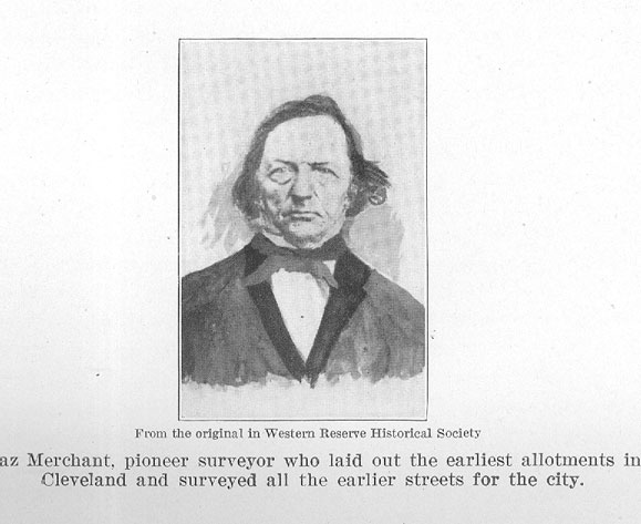
In 1827 Champlain street was opened, and the following year Canal street and Orange alley, later called Frankfort street. In 1829 Canal street was opened. In 1831 Prospect street was opened from Ontario street to Erie, parallel to Euclid street. Ahaz Merchant surveyed this street and it was at first called Cuyahoga street, but before the name was put on the map it was changed to Prospect street. River street, for many years the leading commercial street, was laid out in 1833. The increasing demand for the land near the river mouth led to opening Lighthouse street, Meadow street and Spring street in 1833. High street was laid in 1835. The same year the large block of land between Euclid and Prospect was opened by the cutting of Sheriff street, a mere lane. Lake street, although one of the original streets surveyed, was not opened until 1835. The same year Miami street was confined to its original space, and Ohio street, Rockwell and Bolivar streets were opened, as were also Middle and Clinton street, later called Brownell street. Thus, by 1835, nearly all the streets now in the original town plat, were established. When the population began to increase more rapidly, streets were surveyed through the out lots. Erie street no longer remained the eastern line, but successively, Clinton street in 1835, Perry and Frontier streets in 1838, Sterling street in 1846, and Case avenue by 1850 became the leading transverse streets, and by 1860, Willson avenue was no mean street.
The population pushed out along the great radial streets, and as they diverge like the radiae of a fan, these cross streets became necessary. Some of the transverse streets, notably, Willson, Case, Bolton and Madison avenues are fine, wide streets, but many of them are narrow, and some of the older ones were hardly more than lanes.
Of the radial streets, St. Clair is the northernmost. It was opened in 1816. Originally Federal street was projected a little to the north of it, but it was merged with the "North Highway." The name Federal was discarded and the entire street named after St. Clair, the first governor of the Territory. Warren in his notes of the survey says, "In the beginning of the third and twentieth tallies are small brooks ; the land is swampy and scalded, but hard clay bottom, will require causewaying to be good road, but can be passed as it is and is good for grass." It was a well traveled thoroughfare, leading to the fine residences on the lake shore, to the gardens and farms that extended to Glenville, and later to the state fair grounds and the great race track just this side of Glenville. The part of the street lying east of Erie was paved in the '60s with wood. Later it was paved out to Nevada street, and in 1871 a contract was let to pave it with wood and stone,
1 - See "Corporate Birth and Growth of Cleaveland." Tract No. 62, W. R. Hist. Soc.
HISTORY OF CLEVELAND - 53
(the Nicholson block) to Willson avenue. In 1875 it was paved from Willson to Crawford road. In 1886 it was paved with Medina stone from Erie to Willson. Subsequently its entire length has been paved.
Superior street was planned for the principal street of the city. It is one of the widest streets in America. Originally it stopped at Erie street. Fine houses were built on it between the Public Square and Erie street, and west of the Square it remained the principal retail district until recent years. An extension of the street was made by 1853 to Frontier street, but lot number 168 on Eric street belonging to the May estate had a fine mansion on it, facing Superior street and it was not until 1864 that arrangements were made to extend the street through to the city limits. Superior street was the first paved street in Cleveland. It was a very muddy street before it was paved. Its "continuous mudholes" were denounced as a "shame," but when the question of paving it came up, it was thought by many to be an expensive luxury. The street was planked in 1842 and waA paved with stone and plank in 1850 and when, in 1851, delegates came from Columbus and Cincinnati to celebrate the completion of our first railway, the "planked road of Superior street" attracted universal admiration. This pavement caused litigation on account of alleged discriminations in amounts of assessments, that was finally carried to the Supreme court, where the city council was upheld. Mayor Senter, in his message in 1860, said, "The planking of Superior street has become irreparably dilapidated." The pavement was replenished, and in 1873 the street was paved with Nicholson block, to Willson avenue. In 1873 it was widened from Willson avenue eastward, about two and one half miles. Later it was paved with stone in the downtown section, and with brick in the outlying district.
By 1853 a street parallel to Superior street had been projected, between Superior and Euclid, on the line between the ten acre lots of St. Clair street and Euclid avenue. The new street was at first called Superior avenue, but was later named Payne avenue in honor of Senator Payne, who owned a great acreage on the new street. It was not opened to traffic until 1873. This street was to open a magnificent residence district, but its lots were withheld too long from the market and "Payne's Pastures," as the open squares were called, were later avoided by the home seeker because they bordered the "smoke belt" along the shores of the lake. The downtown end is now being filled with manufactories of the lighter sort.
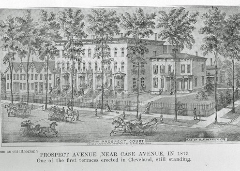
Prospect street was surveyed by Ahaz Merchant in 1831. At first it extended only to Sterling, but it was later extended to Willson avenue, and when East Cleveland was annexed it was continued to Bolton avenue. It was a fine residence street in the days just preceding the mercantile invasion. In 1861 it was remarked by a visitor that it had "grass plots between the walks and the street," and that they were "evened off." The street was sprinkled in this year, and bore all the evidence of a fashionable residence street. It was at first paved with wood, in 1890 was repaved with stone from Erie to Perry, and later with brick and Aheet aAphaltum.
Between Euclid and Kinsman street was a large area that was without acceAs for residence lots until after 1835, when three radial streets were pro-
54 - HISTORY OF CLEVELAND
jected : Cedar street running east from Perry, Garden street and Scovill avenue running eastward from Clinton, all of them to the city limits.
Cedar street in 1875 was graded and curbed from Perry to Willson; in 1890 it was paved with brick to East Madison and to Fairmount in 1891.
Garden street was so named in token of the many pretty gardens that surrounded the cottages of the Germans who built their homes there; later it was called Central avenue. It was paved with Nicholson block from Brownell to Willson avenue in 1872-3. In 1881 it was curbed from Willson avenue to the Cleveland & Pittsburg Railroad tracks, and in 1890 was paved to Willson, and later to the city limits.
Scovill street was named in honor of Philo Scovill (originally spelled Scoville), one of the pioneer business men of the city. It is a narrow street. In 1850 a petition was filed in the city council, asking that the street be changed to an avenue. It was then a residence street, dry, well drained, though unpaved. The street car company when it laid its tracks, paved the track space with stone. Portions of this pavement are still in place though very much worn.
Kinsman street was the old "south highway." It was named after Kinsman township in the 7th range, which was well settled at an early date. It was originally surveyed in 1797 by Warren, who says of it, "The land admits of an excellent highway, but is not as good for grass as that of the centre laid out yesterday." It was renamed Woodland avenue in the '60s. It was one of the splendid streets in the earlier days, with many stately homes, leading out into a beautiful suburban district, and was one of the favorite drives of the town. Its first pavement was the popular Nicholson block. It was paved with stone to East Madison in 1890. Subsequently it was paved to the city limits.
In 1873, Hough avenue was opened from east Madison to Giddings. It is a popular residence street with a considerable business section at the crossing of Crawford road.
Pittsburgh street is one of the oldest streets of the town. It led into the old Newburgh road, a state road, only sixty-six feet wide, and in 1834, Leonard Case was instrumental in having it broadened to ninety-nine feet and it was renamed Broadway. This was one of the most frequented roads of the pioneer days when Newburgh was an important settlement. It had for some years the only grist mill in this vicinity. For many years before factories filled the valley, Broadway was a favorite drive, offering a fine view of the beautiful valley of the Cuyahoga. It was one of the first streets of the city to be paved with stone. The pavement was first laid as far as Independence street in 1871-2. In 1875 from Union to Mill street a wooden pavement was laid; since this it has been relaid with stone, its entire length.
EUCLID AVENUE.
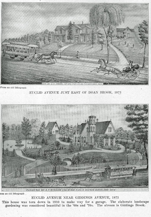
But the most important of these radial streets is Euclid avenue. It is one of the few streets of this country that have become world famous for their beauty, and it formerly ranked with Unter Den Linden, the Champs Elysee, and Commonwealth avenue.
HISTORY OF CLEVELAND - 55
When the first surveying party landed in the Reserve, they soon learned that the hardships to be endured were so unusual that they demanded more pay than they had originally stipulated. General. Cleaveland, at Conneaut, in July, 1796, made an informal agreement which was later made more definite when the party reached the Cuyahoga, stipulating that the forty-one men of the party should be given a township, at one dollar per acre, each to have an equal share, on condition that they pledge themselves to remain in the services of the company to the end of the year and that they make settlement in the township, so that by 1800, forty-one families should have settled in the township. They wisely selected the township next east of Cleveland township and named it in honor of the great mathematician who founded their science, Euclid. When those arrived whose lot it fell to settle in the township the following year, they began at once to build a new road-way from the new metropolis to their possessions. It was surveyed by Warren, as the "Center highway." He says in his notes, "The land admits of an excellent highway to the middle of number 24, and then of a good cartway north of the swamp to the one hundred acre lots ; the soil is preferable to that of the city, timber, oak, hickory, chestnut, box." For several miles along the line of this road, nature had provided a true highway in the ridge that marked the ancient shore line of the lake. This ridge became Euclid Road.
It was surveyed from Huron street to the Public Square in 1815, and this stretch was opened the following year. It is sometimes stated that it extended through the southeast section of the Square to Superior street, but none of the plats show this. Probably in the pioneer days, the ox teams and stage coaches, as a short cut, were driven diagonally across the Square to Superior street, but no formal street was laid out beyond the line of the Square.
At first Euclid was not an important road. It was not as much traveled the first decades as Broadway to Newburgh and Pittsburgh, or even Kinsman road. But as the settlements increased at Doan's corners, Collamer and Euclid, it became he most frequented road. Moreover, it was the great thoroughfare to Painesville, Erie, and Buffalo, and was known as the Buffalo road as late as 1825. Stage coaches, carriages and wagons joined the farmers' ox carts, and by 1830 it was the most important highway along the lake shore.
Its natural advantages early attracted those who wished a pleasant site for their homes near the growing town. At first the stretch between the Square and Erie street was lined with the stately square homes with classic porticos of the early period. (1) About 1837 Truman P. Handy built one of .the first residences,
1 - On Euclid Ave. between the Square and Erie St. (E. 0th) were the stately homes of Samuel Williamson, John Tod, Philo Scoville, Geo. F. Marshall, John C. Grannis, S. 0. Griswold, Dr. Cushing, W. J. Crawford, John A. Wheeler, Geo. A. Benedict, Henry Nottingham, E. N. Keyes, Benjamin Harrington,, Henry Chisholm, T. P. Handy and Edwin Cowles Other Euclid Ave. residents, in the section now invaded by business, were Lyman Kendall, C. W. Heard, Prentis Dow, A. Buttles, H. W. Clark, Prof. Webber, Henry Gaylord, Nelson Monroe, W. D. Beatty, M. B. Scott, William Williams, Judge S. J. Andrews, Freeman Butts, Elisha Taylor, Geo. B. Senter, Rev. Dr. Claxton, John F. Warner, 0. A. Brooks, E. T. Sterling, C. Stetson, Sylvester Hogan, Dr. Elisha Sterling, W. Scofield, B. J. & J. B. Cobb, Anson Smith, Dr. Strickland, Dr. Hopkins, L. Benedict, Josiah Stacey, Geo. A. Stanley, C. E. Fisher. Here were also located the Plymouth Church, St. Paul's, and the Wesleyan Methodist churches.
The pioneer of the business invasion was the Otis block, facing Bond St. The building of this block was viewed with astonishment by the people, it was so far away from the business center. Just as, in 1837, the people wondered at the audacity of Truman P. Handy
56 - HISTORY OF CLEVELAND
"way out of town" near Erie ; the home was subsequently used by the Union Club, the Hippodrome now occupies the site. When the town crowded the homes beyond Erie street, the wealthier residents began the custom of building their houses back from the street, providing ample lawns that sloped gracefully to their doors. By 1860, the street as far as Willson avenue was virtually a park, each home surrounded by spacious grounds. It was the show place of the city and in its golden days its fame was deserved. Distinguished visitors in these years, have left glowing accounts of its stately beauty, and even today, after the advent of the factory age with its clouds of smoke, its noxious, leaf destroying gases, and its crowding commercialism, large stretches of the famous avenue refuse to be robbed of their pristine glory. (2)
It has been our street of pageantry. Not a noted event in the past seventy years but Euclid avenue has borne an important part therein. The completion of the Cleveland & Pittsburgh railway, made it the gateway through which the notables of the land have been welcomed to our city. Down its broad and sheltered isles, were borne the remains of Lincoln, Garfield, Hay, and Hanna. Its stately mansions viewed the pageantry of honor to Grant, to Sherman, and the soldiery of the great war. Notable conventions sent their parades past its broad lawns, and great festivals, national and local, have shared their gaiety and throngs with this street of splendor.
"Euclid avenue in the early days and a long time afterwards, was by no means a popular highway stretching along at the southerly side of the ridge. It was the receptacle of all the surface waters of the region about it, and during much of the time was covered with water, and for the rest of the year was too muddy for ordinary travel." *
The street was early planked from Perry street to the city limits. Logs had been used for "Corduroy," in the swampy places near Willson avenue when it had been . made a state road. In 1853 the city council undertook to repair it, and the hope was expressed that "the misery of a wilderness corduroy may never again fall upon Euclid street."
In 1852 complaints were registered because after every rain a pond of water accumulated at the corner of Erie and Euclid, 'called the "Euclid Frog Pond!' In that year an ordinance was passed providing that each owner must pave his own sidewalk. But the city was not vigilant, and very little paving was done. In 1857 there were more complaints. Surface water gathered upon the streets because of the poor drainage of Garden, Brownell, and Chestnut streets. • The rains would flood the street and the recession of waters deposited silt and ill
building a house "way out of town," when he built his fine residence near Erie. One by one the homes gave way to business structures. Among the last to disappear was the Chisholm borne, when the New England building was erected in 1894, and the Handy mansion, where the Hippodrome was built in 1908.—See "Annals Early Settlers Association," Vol. III, pp. 346 ff.
(2) John Fiske, the historian, in a lecture before the Royal Society of Great Britain, spoke of our avenue: "In Cleveland—a city on the southern shore of Lake Erie, with a population about equal to Edinburgh—there is a street some five or six miles in length, and over one hundred feet in width, bordered on each side with a double row of arching trees, and With handsome stone houses of sufficient variety and freedom in architectural design, standing at intervals of from one to two hundred feet along the entire length of the street. The effect, it is needless to add, is very noble indeed, the vistas remind one of the nave and aisles of a huge cathedral."
(See S. O. Griswold, "Corporate Birth and Growth of Cleveland"—Tract, No. 62.)
HISTORY OF CLEVELAND - 57
smelling refuse. July 28, 1857, an ordinance was introduced into the city council providing for the grading of Euclid avenue, from Perry street to the city limits. This cost three thousand, and eighty-three dollars and nine cents.2 A culvert was dug along Sterling street to the lake to drain Euclid avenue and put an end to the perennial "Lake Euclid." Under authority of an ordinance passed June 7, 1859, Euclid avenue from the public square to Erie street was improved at a cost of seven hundred and seventy-six dollars and fifty cents by constructing a carriageway twenty-five feet wide, filled with gravel to a depth of one foot. The roadway of the street was made forty-one feet wide. A further improvement was made between the same points under authority of an ordinance passed July 10, 1860. At this time the gutters were paved with stone for a width of eight feet from the curb line, on each side of the street. From this it would appear that a stone pavement was put down between the curbs and the gravel carriageway previously built and the old planks ripped up. But the street was not kept in a tidy manner. In 1862 complaint was made that weeds were allowed to grow between the sidewalk and the street. In 1864 portions of the street were repaired and in 1865 the council passed an ordinance that Euclid, together with parts of St. Clair and Prospect street be sprinkled in the dry summer months.
When East Cleveland was annexed in 1872, Euclid road beyond Willson avenue was planked, and ditches made on either side. Soon many planks were missing to the great discomfiture of travelers. In the '60s Nicholson pavement was laid to Willson avenue.
In 1873 contracts were let to pave with Medina sandstone from the Public Square to Erie. In 1875 pavement was laid from Perry to Willson. By 1882 these pavements were in miserable condition and repaving with Medina sandstone was begun. In 1886 the street was paved from Fairmount street to the city limits, and an embankment built over Doan brook, and in 1891 the avenue was repaved with Atone blocks from the Square to Perry street and later this stretch was laid with asphalt.
When the west side was united to the city the leading street connecting the two towns was Columbus street passing over the most substantial bridge then spanning the valley. It connected with the state road to Lorain, later called Lorain Street, and with the pike to Wooster.
Detroit street was virtually a continuation of Euclid, and followed a lake ridge to the westward, merging into the state road to Toledo and Detroit. Some semblance of a radial plan was attempted on the west side, with Franklin circle as a center. Between Franklin, formerly Prospect street, and Detroit street, and between Monroe and Bridge streets the streets were laid out at right angles. But the contour of the land did not readily lend itself to so regular a plan, and the west Aide has developed the same desultory street system as the east side.
Since 1870 the number of streets in the city has multiplied rapidly. The city directory of 1837 names seventy-one streets, eight alleys, three courts, two parks, and three lanes. In 1849 there were sixty-nine streets, seven lanes, three parks and places, and ten alleys. In 1850 there were eighty-five streets, three lanes, two parks and ten alleys. The first avenues were named in 1852. They were, Case avenue, Sawtell avenue, Sterling avenue, and Willson avenue, all newly
2 - City Reports, 1858.
58 - HISTORY OF CLEVELAND
laid out, and Superior avenue, a renaming of Superior street. In 1855 Cedar street became an avenue, and Clinton street, named after DeWitt Clinton, was changed to Brownell. The same year Division street became Center street, and Second street became Hill street, and York street was renamed Hamilton street. On the west side, Prospect street was called Franklin street.
In 1860 there were one hundred and eighty-two streets, five avenues and three alleys. In 1870 there were on the east side of the river two hundred and forty- five streets, twenty-five lanes and alleys, and seventeen avenues, while on the west side, there were one hundred and ninety-eight streets, six lanes and alleys, and sixteen avenues. The leading avenues were, Case, Cedar, Giddings, Longwood, Payne, Sawtell, Scovill, Sterling, Wade, Willson, Woodland, Clark, Gordon, Jennings, Madison, Rhodes, Starkweather and Scranton. Of course, with such a number of streets aspiring to the dignity of avenues, many were misnomers. But Euclid street was now first called an avenue.
In 1880 the number of streets had been increased to nine hundred and seventy- five, and the number of avenues to one hundred and eighty-three, while there were one hundred and thirteen lanes, alleys and places, and five roads. This number has multiplied with the population.
Sidewalk lines were established by ordinance July 11, 1832, when it was resolved "that sidewalks be established on the several streets in the village of Cleveland, commencing on the lines of the streets and extending toward the centre and that they be the width herein specified : on Superior street, sixteen and one-half feet; on all streets six rods wide, twelve feet ; on all streets four rods wide, ten feet; and on all other streets, lanes and alleys that are, or hereafter may be established within said village of such width as may be particularly designated." It was provided "that when a sidewalk is embraced within a railing, heavy articles of merchandise such as salt, tar and potash kettles, may be placed under and without the railing on the street, a distance not exceeding seven feet." "If any person shall willfully drive or lead any wagon, cart, carriage or sleigh of any description on any of the sidewalks he shall be fined one dollar to twenty dollars."
STREETS, NAMES AND NUMBERS.
There was for years no plan in the naming of the streets and in numbering the buildings. As each addition was plotted, the streets were named by the owners according to their individual tastes. The names of the principal streets are either of geographical significance, or are those of pioneers or other personages. The original streets of the village had names of geographical import. The numbering of the buildings was haphazard. In 1855 the city council was asked to pass an ordinance providing for the proper numbering of houses and to put up street signs. "Not a street in the city is properly numbered," said the papers of that date.
Several attempts were made in recent years to devise some plan for systematizing the numbering of the houses and the naming of the streets. But the chaos into which the individualism of allotments had led the streets, was not easily resolved into orderliness. Finally, in 1904-5, a 'plan was promulgated by the Chamber of Commerce, and adopted by the city. It divides the city into four sections. On-
HISTORY OF CLEVELAND - 59
tario street is the meridian between the east and west divisions. Euclid avenue divides the northeast and southeast sections, Lorain avenue the northwest and southwest section. The east and west thoroughfares retain their names and are called avenues, while all north and south streets lose their names, and are numbered. The house numbers are controlled by the numbers of the streets, each block beginning with the one-hundred corresponding to the number of the street at which the block commences, and the numbers are continuous. Diagonal thoroughfares are called roads ; the north and south alleys, or lanes are called places, and those running east and west, are called courts. This plan became effective December 1, 1906. The change was made at the sacrifice of many fine historic names and the conglomeration of short streets made the numbering almost ridiculous. But after the confusion incident to the change passed away, the new order seemed to respond to the real needs of the city better than was thought possible, and the attempts made by merchants to repeal it, were finally abandoned.
PAVEMENTS.
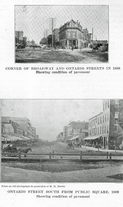
The streets of early Cleveland were in miserable condition in spring and fall. Up to 1850 the condition of Superior street was a "shame" and the newspapers frequently allude to itA "swamps and puddling holes." Water street was a "fathomless depth of mud," The street crossings were almost impassable during wet weather. Such sidewalks as were laid were not kept in repair. "Through the untiring efforts of Mr. Wm. Case, in the year 1852 Superior street was planked with three inch oak lumber, and became passable at all seasons of the year." (1) River Street, "one of the greatest thoroughfares of the city," was also laid with planks, and in 1854 Union street was graded and planked so that one team of horses could pull a load up the hill in muddy weather. In 1860 Mayor Senter in his annual report says, "The present condition of Water street, north of St. Clair, reflects no credit upon the city."
A more substantial pavement was laid in Cleveland on East River street from Superior street to St. Clair street, paved under authority of an ordinance passed May 20, 1856. The work of paving was done in 1857.
These pavements were poorly made and were thought to cost extravagant s.
In 1853 the legislature passed a law empowering cities to collect a road tax, and Cleveland was made a district by the city council for the collection of such tax. William Gurien was appointed supervisor, and he had his troubles in collecting this tax of one dollar and fifty cents in money, or two days' work on the streets from each male citizen. It was called a poll tax by the people, and after collecting about eight thousand dollars, this method of raising money for improving the streets was abandoned.
Progress in paving was extremely slow. In 1889 the city engineer reported that the paving of streets began in 1854, that in 1889 the city had four hundred and forty miles of streets and alleys, and had payed "an average of less than two miles a year," that Cleveland was outranked by other cities, and did her street improvements "piecemeal."
1 - "Annals Early Settlers Association," No. VIII, p. 165.
60 - HISTORY OF CLEVELAND
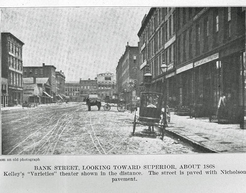
By 1860, over a mile of stone pavement had been laid. In 1862, wood block, or Nicholson pavement was experimented with, and a half mile laid. It was a popular pavement but not durable. By 1878, one hundred and one miles of it had been laid, while fourteen and twenty-one hundredths miles of a combination of wood and stone pavement had been laid, a stone roadway with wood on the side. The older wood pavements by 1880 were in a deplorable condition. "Broadway, from the top of the hill to Union street, St. Clair from Erie to Willson, and Euclid avenue from Perry to Fairmount, are in a very bad condition." * The repaving of all wood streets was begun in 1880. Medina sandstone replaced the old pavements. In 1871 experiments were made with coal tar pavement laid on top of stone paving, in Superior street on the Square. In the fall of 1872, Prospect street from Case avenue to Kennard street was paved with coal tar concrete and the following year it was extended to Willson avenue. Euclid avenue, from Fairmount street to city limits (three-fourths mile) was then also surfaced with coal tar-concrete.
Macadamized roadbeds were begun in 1871 on side streets in East Cleveland, Woodland avenue from Willson avenue to Madison street were also macadamized, but was topped with a layer of Medina stone four inches thick.
In 1872 a steam roller was purchased for the macadam roads. But Medina stone, either laid in bituminous cement, or "laid dry" remained the favorite ; indeed, in 1885 the engineer virtually excluded all other kinds.
In 1888, the first brick pavement was laid by the city on Bolton avenue and on Carroll street. It was laid on an earth foundation, and rolled and tamped. Private parties had laid brick pavement in Euclid place the previous year.t The first Trinidad asphalt pavement was laid on Ingleside avenue and on Prospect street between Case and Willson, in 1889-90. The former was done by the property owners, the latter by the city.
In 1889, the legislature allowed a one mill levy for street purposes, and paving made better progress. Since 1895, about eighteen miles of pavement per year, have been laid. Brick and Medina stone remain the favorite pavement.
In January, 1907, Cleveland had one hundred and eighty-two miles of brick pavement, ninety-two miles of stone pavement, twenty-three miles of asphaltum, one mile of Belgium blocks, one half mile of bithulithic, one and one-half miles of macadam. Three hundred miles of pavement on six hundred and fifty-one and four-tenths miles of streets. By January 1, 1910, about eighty-five miles had been added to the pavement. These figures do not include the park areas.
Most of the streets being sandy, brick is laid without other foundation, and filled with Portland cement grout. Gutter and curb are pitch filled for expansion. The average price has been : brick, fifteen and one-half cents per square foot ; stone, three dollars and fifteen cents per square yard; asphalt, two dollars and twenty- five cents per square yard ; tumen, two dollars and ten cents per square yard.
Wherever traffic is heavy, stone is laid, with a six inch cement foundation. Almost from the start abutting owners paid the largest cost of paving ; assessment
* Engineer's report, 1880.
t Walter P. Rice, C. E., made the first endurance tests for paving brick in this part of the state, 1887-8.
HISTORY OF CLEVELAND - 61
being per foot front. Brick pavement is found to be most economical for residence and light traffic streets. Its life is from twenty to thirty years.
The fine flagging found in abundance in this vicinity, soon replaced the wooden walks of the village days and the former has given way to concrete on business streets.
STREET CLEANING.
In the days of the village, there was no attempt made at municipal street cleaning. "The officers of the corporation are requested to pass a law prohibiting swine to run at large in the village; also to prevent people from riding at an immoderate rate through the streets. * * * The civil officers should be more attentive to their duty and see that the laws are more constantly complied with." (5) Streets seemed to be commons where cows wandered at random as late as 1849, when the "Herald" started an agitation, for a pound.
In 1852, the following ambiguous notice concerning an ordinance, commonly known as the "Hog Ordinance," was published: "All persons owning hogs, are hereby notified, that the ordinance restraining the same from running at large within the city of Cleveland, will be enforced unless the same be restrained. James Lawrence, Marshall. February 26, 1852." In 1858 cows running at large were "becoming an intolerable nuisance," and a city ordinance forbade them being at large in the night. It appears that this ordinance was not enforced and that shrubbery and flower beds suffered.
In 1855 it was seriously suggested that the police court prisoners be put to cleaning the streets. There are many references in the newspapers to the slovenly streets. "We noted yesterday evening, when the shovel had doubtless made its appearance for the first time in a twelvemonth, a pile of filth under an outside stairway leading to the second story of a building on the corner of Union and St. Clair streets, three or four feet deep, and such filth ! And this, only one instance in many that came under the observation of those passing through streets in balked by tenants." (6)
In 1865 the sprinkling wagon made its appearance, and a more systematic cleaning was undertaken. In 1870 Mayor Buhrer called the councils attention "to the large expenditure required for cleaning the numerous streets and avenues of the city. There are about ten and one-half miles of stone pavement and about eight and three-quarters miles of Nicholson pavement, which are cleaned on the average of four or five times a year, and this is all done by manual labor." In 1883 the city began to sweep the streets with a sweeping machine. Mayor Farley said, in his message to the council: "About the only difference under the old method of cleaning, between a dirt street and a paved one, is the depth of the mud." The sweeping was done under contract by a private party. But there were not enough machines used and the result was not very satisfactory, although it cost eighteen thousand, nine hundred and ninety-four dollars the first year, eight thousand, dollars more than the old way. In 1900-1 an earnest attempt was made to introduce the "white wings" system on an efficient basis. City Engineer Walter P. Rice went to New York to study the system perfected. by Col. Waring.
5 - "Gazette," Sept. 1, 1818.
6 - Daily Herald," Vol. 21, No. 105.
62 - HISTORY OF CLEVELAND
He prepared a bill licensing vehicles for raising the necessary money. But the legislature failed to pass it. The following year, "white wings" were put on the down town streets, but the system has never been given the military perfection achieved under prompt discipline. In 1902, an effort was made to clean every important street twice a week, and all cross streets once a week. In 1905, the "white wings" cost fifty-one thousand, three hundred and ninety dollars and ninety-five cents, and machine cleaning and "pickup gangs," cost eighty-two thousand, four hundred and forty-three dollars and sixty-eight cents.
In 1906 flushing machines were used, and the city began to collect ashes and refuse.
STREET LIGHTING.
The first street lights were kerosene lamps placed on posts. They shed but a dim light and people going on to the side streets were wont to carry lighted lanterns on dark nights.
In March, 1837, the council appointed a special committee to "inquire into the expediency of lighting Superior street from the river to the Public Square, and how many lamps will be necessary, and the expense of lamps, lamp posts, oil, etc., and the best method of defraying the expense satisfactorily to the citizens."
The oil lamps remained the only street illuminant until artificial gas was introduced. On February 6, 1846, The Cleveland Gas Light and Coke Company was organized, and two years later, under the active management of Moses G. Younglove, works were built and pipes were laid for distributing the gas. It appears that the early pipes leaked a great deal, and that they were laid in a very careless manner. The gas burner was a great convenience and was the wonder of its day.
The charter gives the company permission to lay pipes under given restrictions, the company was to furnish public lights as cheap as light was furnished in Buffalo and Cincinnati at that date, and to private parties the rate was never to exceed three dollars per one thousand feet. The city must furnish and own the lamps, and is given the right to extend pipes and connect mains if the company refuses. The council is given the right to regulate the price for ten year periods.
The following table indicates the rate charged for gas.
In 1859 the rate was $3.00 per thousand cubic feet.
In 1861 the rate was $2.50 per thousand cubic feet.
In 1863 the rate was $2.75 per thousand cubic feet.
In 1866 the rate was $3.00 per thousand cubic feet.
In 1867 the rate was $2.50 per thousand cubic feet.
In 1875 the rate was $2.00 per thousand cubic feet.
In 1880 the rate was $1.80 per thousand cubic feet.
In 1881 the rate was $1.65 per thousand cubic feet.
In 1883 the rate was $1.50 per thousand cubic feet.
In 1884 the rate was $1.40 per thousand cubic feet.
HISTORY OF CLEVELAND = 63
In 1887 the rate was $1.25 per thousand cubic feet.
In 1888 the rate was $1.00 per thousand cubic feet.
In 1892 the rate was $0.80 per thousand cubic feet.
In 1900 the rate was $0.75 per thousand cubic feet.
This rate is still in force.
On the west side the People's Gas Light Company was chartered in 1867. Its charter followed closely the charter of the Cleveland Gas Light and Coke Company, except public lights were not to exceed $2.25 per thousand cubic feet, and the city was given the right to purchase at the end of twenty years, five appraisers to fix the price.
Both companies now install meters and pay to the city treasurer six and one- half per cent of the gross receipts. In 1904, this amounted to eighty-six thousand, six hundred and twenty-three dollars and ninety-eight cents.
The early lamps were run on a "moonlight schedule ;" that is, they were not lighted when the moon shone full, and as late as 1861, all lamps were put out at midnight, leaving the town in total darkness.
In 1872 Charles F. Brush began his historic experiments with electric lighting. and Cleveland was the first city in the world to have its streets extensively lighted by electricity. The first street arc light was lighted in the Square in 1878. Twenty lamps were lighted and the Square was crowded with people. There had been a great deal of speculation as to the power of the light, and some wore smoked glaAses to protect their eyes from the glare.
In 1881 the city erected four steel masts each two hundred feet high. One in the center of the Square, one at the corner of Bank street (West Sixth) and Lake street, corner of Water street (West Ninth) and Superior, and one at the corner of St. Clair street and Erie (East Ninth). Each mast was provided with eight arc lightA, of four thousand candle power each. In 1893 these masts were taken down.
In 1884 there were Aixteen electric lights, each of two thousand candle power, and as the failure of the high masts was made apparent, the number of lower lights was greatly increased.
Vapor lights were introduced in 1884. In 1898 the Welsbach, and in 1906 the Nernst lights were introduced.
Natural gas was introduced into the city in 1902, when the East Ohio Gas Company, affiliated with the Standard Oil Company, was given a perpetual franchise. The cost of the gas is stipulated in the franchise at thirty-one cents per thousand cubic feet.
BRIDGES AND VIADUCTS.
The topography of Cleveland makes many bridges and viaducts necessary. The Cuyahoga valley and the many runs that merge into it divide the city into sections, or islands, roughly known as the west side, east side and south side. These Aections are again subdivided by Walworth run, Morgan run, Kingsbury run, and several minor ravines, some of which have in recent years been filled and sold for lots.
64 - HISTORY OF CLEVELAND
The first demand for bridges was on the flats, for the purpose of connecting the east and west sides, and later for providing for the business traffic created by the establishment of manufactories, ship yards and lumber yards in the valley. The expansion of the suburbs later created need for viaducts, to make rapid transit possible.
There are three distinct periods of bridge building, following the needs of the community and the advance in engineering. First, the period of wooden bridges built for wagon traffic, made of timbers with masonry abutments. These had a swing or draw span for allowing boats to pass. As late as 1853 only three of these were needed : one at Columbus street, one at Seneca street, and one at Division street. The advent of the railway brought the second period with its need of a better bridge, and by 1860, iron and steel structures were introduced. Cleveland was a pioneer in the manufacture of these new bridges. Third, the viaduct period, when the broad valleys were spanned by high level structures, thus diminishing distance and bringing the isolated parts of the city together. These were built first of masonry and steel, then entirely of steel, and lately of great concrete arches.
There are over seventy bridges in the city. Nine draw bridges owned by the city, and twelve owned by the railroads, and about fifty stationary bridges owned by the city and the railroads. There are also several under construction at the present time (low). Only the older and most important ones built by the city can be noticed here.
The ferry at the foot of Superior street, operated by Elijah Gunn, was for some years the only means of getting to the west side. A bridge was not built at this point because it would obstruct navigation. A floating bridge constructed of whitewood logs, was built some years later, where the Center street bridge now spans the river. "When vessels wished to pass, the logs were floated to one side, and were brought back into place by means of ropes. This was the first bridge across the Cuyahoga."'
COLUMBUS STREET BRIDGE.
This, the first substantial bridge built over the Cuyahoga river in Cleveland, was the direct outcome of the land speculation in 1835-8. In 1837, James S. Clark and several associates platted a large piece of round skirting the river, and called it "Willeyville" after John W. Willey. Through this allotment ran Columbus street, so laid that it connected with the Wooster and Medina turnpike on the west side of the river. A bridge was built at this point. The Columbus street hill was graded, and it was hoped that traffic could be deflected from the south and west, over this bridge, up Columbus street hill into town. This bridge was built by Clark and his associates. It cost fifteen thousand dollars. The following description is from the city directory of 1837. This bridge is "supported by a stone abutment on either shore and piers of solid masonry erected in the center of the river. Between the piers there is a draw sufficient to allow a vessel of forty-nine foot beam to pass through. The length is two hundred feet, the breadth, including the sidewalks, thirty-three feet, and the height above the piers
1= "Annals Early Settlers Association," Vol. IX, p. 43.
HISTORY OF CLEVELAND - 65
above the surface of the water, may be estimated at twenty-four feet. The whole, with the exception of the draw, is roofed and enclosed, presents an imposing appearance, and reflects much credit on the architect, Nathan Hunt. * * * This splendid bridge was presented to the corporation of the City of Cleveland by the owners, with the express stipulation that it should forever remain free for the accommodation of the public, although the legislature had previously chartered it as a toll bridge."
The famous "Bridge war" was fought over this bridge. The people of Ohio City saw the traffic from Elyria, Brooklyn, and the intervening farming country avoid their town and pass over the new bridge to their rivals on the east side. Meanwhile, the Cleveland city council directed the removal of one half of the old float bridge at Main street, one half of this bridge belonging to each town. The mandate of the council was obeyed at night, and when the people of Ohio City realized that they were the victims of strategy, they held an indignation meeting and declared the new bridge a public nuisance. Their marshal organized a posse of deputies, and the bridge was damaged by a charge of powder, exploded under the Ohio City end. Two deep ditches were dug near the approaches, on either side, and the bridge virtually rendered useless. Then a mob of west siders with evil intent marched down on the bridge, led by C. L. Russell, one of their leading attorneys. But they were met by the mayor of Cleveland, who was backed by some militia men, a crowd of his constituents and an old field piece that had been used in 4th of July celebrations. There was a mixup ; planks, stones and fists were freely used. But the old cannon remained silent because benevolent Deacon House, of the west side, had spiked it with an old file. The fight was Atopped by the county sheriff and the Cleveland marshal.
The city council, October 29, 1837, ordered the marshal to keep an armed guard near the bridge. But the courts soon put a stop to the petty quarrel between the two villages.
In ten years the old bridge had grown too small, and in 1846 agitation was begun to build a larger one. The towns could not agree on a plan, Ohio City maintaining that Cleveland owned only to the middle of the river. The county promptly Aettled the dispute and built the bridge. In 1870, Columbus street was Aill "one of the leading thoroughfares," and an iron bridge was built, which was replaced in 1898 by a new bridge at a cost of eighty thousand dollars. The draw of thiA bridge is operated by electricity.
DIVISION STREET BRIDGE.
The natural route from downtown Cleveland to the west side was by way of Division street ; a bridge was built in 1853. It was a wooden drawbridge, and the railroad age soon made it necessary to replace it with an iron structure.
SENECA STREET BRIDGE.
In r857, the city engineer reported that the, Seneca street bridge collapsed, "being overloaded with cattle." A new one replaced it. It was a wooden bridge of the type then common, with a draw operated by hand. The city council
66 - HISTORY OF CLEVELAND
had sent a committee to Chicago, the previous year to study bridges, there having been a good deal of agitation over the question whether two or three should be built. The wooden bridge was replaced some years later by an iron one; and in 1888 another bridge was built with one pivot span of one hundred and eighty feet, and one fixed span of one hundred and five feet.
June 25, 1903, the city completed the new Middle Seneca street bride. It is a Sherzer Roller lift bridge, the first of its kind built by the city. It has a roadway of twenty-three feet, eight inches wide, and two six foot walks. It cost one hundred and sixty thousand, and seventy-two dollars and forty-four cents.
MAIN STREET BRIDGE.
This bridge was one of the first iron bridges built in the city. It was completed July 3, 1869, and was two hundred feet long, and thirty-one feet wide. In 1885 it was rebuilt and the draw operated by steam.
LIGHTHOUSE STREET BRIDGE.
This bridge, later known as Willow street bridge, was authorized by the city and the state board of public works, in August, 1856. It was much opposed by the marine interests. In 1898 a new bridge with its draw operated by electricity, was put in place.
CENTER STREET BRIDGE.
A wooden drawbridge was built in 1863. Within a decade it became unsafe, and in 1871 plans were made to replace it with an iron draw, "Post patent diagonal truss," made by the McNairy & Claflin Manufacturing Company at a cost of thirteen thousand, two hundred and fifty dollars. In 1900 a new bridge was completed, at a cost of fifty-seven thousand dollars.
JEFFERSON STREET BRIDGE.
This bridge crossing the river and canal was planned 1871. It was completed the following year, at a cost of thirty-nine thousand, two hundred and seventy-five dollars and thirty-five cents. Eighteen thousand, one hundred and sixty-four lineal feet of piles were used in its substructure. The draw over the river was one hundred and fifty feet long, and the span over the canal one hundred and seventeen feet. The approaches were each twenty feet wide. The bridge was of iron, made by the King Iron Bridge Company, and at that time it was the finest bridge in the city.
WALWORTH RUN VIADUCT.
This was the first of the large viaducts built by the city. It was built to span the Walworth run and the Big Four tracks, was built of iron, with three spans, one hundred feet, seventy-five feet, and eighty-five feet, respectively. The total cost was seventy-nine thousand, two hundred and fifty-four dollars and thirty cents-.
HISTORY OF CLEVELAND - 67
In 1886-7 it was rebuilt of iron and steel, with a forty foot roadway paved with pine blocks, and two walks each eight feet wide.
THE CENTRAL WAY.
The Central way was opened tinder the tracks of the Cleveland and Wheeling railway in 1872, and it became the principal thoroughfare for heavy traffic, of the iron mills and refineries in that section.
In February, 1883, the old wooden drawbridge in lower Central way, the last of the old wooden bridges in this city, was swept away by the big flood, and a new iron bridge, one hundred and eighty-three feet long replaced it.
SUPERIOR STREET VIADUCT.
But all these bridges did not do away with the slow and laborious travel down the hills and across the flats to the other side of the river. More direct means of communication were necessary. A high level bridge was advocated in the '6os. Meetings were often held to bring the subject to a focus. Great opposition developed by parties who had pecuniary interests at stake and the site of the bridge was the subject of heated controversy. It was not until 1870 that the matter took definite shape, when Mayor Stephen Buhrer and the city council determined upon a plan of procedure. January 30, 1872, John Huntington introduced a resolution into the city council providing for a special committee to report on the feasibility of a bridge across the river at Superior street and to confer with the officials of the Cleveland, Columbus, Cincinnati and St. Louis railway. This committee consisted of Mayor F. W. Pelton, the city engineer, C. H. Strong, John Huntington and H. W. Luetkemeyer. On the 19th of March this committee made an extensive report detailing two routes and their cost, one from the Atwater building on Superior street to the junction of Pearl and Franklin streets, and the other from the corner of Merwin and Superior streets to the intersection of Pearl and Detroit streets. The latter route was favored and after the general assembly had granted the requisite authority, the voters of the city gave it their approval by a majority of five thousand, four hundred and fifty-one. The plan involved, first, the lowering of the Big Four tracks so that the bridge could pass over them; the tracks were lowered so that they passed under the crossing at Champlain, South Water, Superior, Union, St. Clair and Spring streets. The cost of this alone was estimated at five hundred and sixty- five thousand, five hundred and forty-nine dollars, of which the city paid three hundred and twenty-five thousand, three hundred dollars. Second, the vacating of the canal from near Superior street to near the city limits, about three miles, including the old weigh lock and the two locks entering the river, the city to make a new entrance to the river at the new terminus of the canal. The state had leased the canal to a priate corporation, and these lessees were paid one hundred and twenty-five thousand dollars by the city. This was "virtually a gift," as the mayor said (1877), because their lease expired May 31, 1881. The cost to the city of moving the locks and vacating the canal bed was three hundred and sixty thousand dollars.
68 - HISTORY OF CLEVELAND
A great many injunction suits pertaining to the securing of the right of way, hindered the progress of the work. It was not until December 27, 1878, that the bridge was completed, and the total cost was two million, one hundred and seventy thousand dollars. It was opened a free bridge, although the original act allowed the collecting of toll.
The bridge, at the time, was one of the notable engineering feats of the country. Its total length is three thousand, two hundred and eleven feet ; its width, exclusive of the draw, sixty-four feet, the roadway being forty-two feet and the sidewalk eleven feet in width. The draw is three hundred and thirty-two feet long and forty-six feet wide; its roadway being thirty-two feet, and its walks seven feet. The draw is seventy feet above high water mark. The western end of the bridge is supported by ten stone arches, eight of eighty-three feet span and two of ninety-seven and one-half feet span. In the foundation, seven thousand, two hundred and seventy-nine piles were used, eighty thousand, five hundred and eight perches of stone in the masonry, and fifteen thousand, five hundred yards of gravel tilling. The pile foundations bear an approximate weight of one hundred and forty thousand tons of the ten great aches, and twelve thousand, five hundred tons of the iron work, while the draw piers support six hundred and ten tons.
On December 28, 1878, the great bridge was dedicated to the public. The Cleveland light artillery fired the federal salute at daybreak. At t0 :30 a. m., there was a gay parade, the military and civil orders, the fire department and citizens forming the ranks, and at 12 :30 a mass meeting was held in the old Tabernacle, at the corner of Ontario and St. Clair streets, where the new Engineer's Wilding is now in the course of erection. Here addresses were made by Mayor Rose, Governor Bishop of Ohio, Governor Mathews of West Virginia, and others. In the evening a banquet was given at the Weddell house. Hon. Amos Townsend who had represented this district in congress was toastmaster.
On the 29th the bridge was opened for the public use, and from that day to the present a constantly .increasing stream of traffic has demonstrated its need.
The drawbridge was opened three thousand, three hundred and eight times the first year, and three thousand, five hundred and seventy-two vessels passed through.
In 1905 the swing span was widened from thirty-two to thirty-six feet, and in 1908 the Superior avenue approach was widened and a shelter platform erected for passengers waiting for street cars.
KINGSBURY RUN VIADUCT.
The necessity of a bridge between Davis and Humboldt streets was felt before 1880. In 1883 the city engineer suggested a plan ; the following year contracts were let at an estimated cost of two hundred and fifty thousand dollars, and the substructure was begun late in 1884. In July, 1886, it was opened to the public. This bridge is eight hundred and thirty-four feet long. On December 15, 1886, Kingsbury run trestle was completed. It is of wood, four hundred and ninety and one-half feet long with a thirty-six foot roadway and two foot-
HISTORY OF CLEVELAND - 69
ways, each six feet wide. The cost was seven thousand, eight hundred and eighty-four dollars and sixty-seven cents. It was designed to ultimately fill in the trestle with soil.
PETRIE STREET BRIDGE.
In July, 1887, a timber trestle, five hundred feet long was completed over Morgan run, at a cost of five thousand, four hundred and thirty-one dollars and thirteen cents. The bridge has a twenty foot roadway and two walks, each four and one-half feet. It is seventy feet above the run.
CENTRAL VIADUCT.
The growing demands of the south side for better access to the city, were finally pressed upon the city council. March 3, 1879, James M. Curtiss, representing that section of the city in the council, introduced a resolution directing the city engineer to report on the best plan for a bridge to the south side. But nothing was done until 1883, when the council directed a popular vote on the question, which was carried in the affirmative by six hundred majority, and the council authorized the expenditure of one million dollars. The usual contentions as to location were brought to an end by the adoption, in July, 1885, of the route from the junction of Ohio and Hill streets to Jennings avenue.
In December, 1885, the city council passed an ordinance authorizing its construction. November, 1886, bids were opened for the substructure, and two weeks later for the superstructure. On May 5, ground was broken for the south pier, and from that day the work proceeded without serious delay or interruption, and on December 11, 1888, the bridge was opened to the public. A procession of soldiers and citizens crossed the Superior viaduct, thence by way of the new Abbey street viaduct to the entrance of the Central viaduct, where it halted for the final ceremony of transferring the bridge from the builders to the city. Zenas King spoke in behalf of the King Iron Bridge and Manufacturing Company and other contractors, and Mayor B. D. Babcock accepted the bridge. The procession then proceeded across the new viaduct to the city hall, where it was reviewed by the city officials. In the evening a banquet was given at the Hollenden hotel.
This is the longest bridge in the city. Its total length is three thousand, nine hundred and thirty-one feet ; the Walworth run span is one thousand and ninety-two feet ; the Cuyahoga river span is two thousand, eight hundred and thirty- nine feet, the roadway is forty feet wide, and the walks each eight feet. It is one hundred and one feet above high water mark. In the piers sixty-four thousand, four hundred and forty-two lineal feet of oak were used, and seventeen thousand, four hundred and seventy-two feet of protection; seven hundred and sixty-two thousand, eight hundred and ninety-one feet of oak foundation timber, and one hundred and eighty-six thousand, five hundred and forty-nine feet of pine ,foundation timber were use. In the foundation, one hundred and fifty-two thousand pounds of iron were used and four thousand, five hundred and eighty-four yards of concrete, and seventeen thousand and ninety-two yards of masonry. In the superstructure there are four thousand, five hundred and
70 - HISTORY OF CLEVELAND
fifty-two tons of iron. The cost of the viaduct was six hundred and seventy- five thousand, five hundred and seventy-four dollars, of the approaches twenty- two thousand, four hundred and seventy-two dollars. The entire cost including approaches and right of way, was eight hundred and eighty-five thousand dollars. The amount authorized was one million dollars. Time of construction, two years, seven and one-half months. The bridge has been a perennial source of discussion as to its safety. Only six years after its completion, the city engineer reported that the hillside on the west side of the river was slipping at the rate of one inch per year, and thereby moving slightly the piers embedded in the slope, and that the pedestals in the vicinity of Seneca street were slipping. Some years later cast iron blocks were placed on the tops of the pedestals to overcome the effects of settling.
On November i6, 1895, an electric car was run over the open draw and plunged into the valley, killing seventeen persons.
In 1906 the city engineer found that the west hillside had slipped toward the river twenty inches in twenty years.
BROOKLYN VIADUCT.
Brooklyn viaduct, over Big creek, connecting South Brooklyn with the city, was completed in 1895. It is one thousand, five hundred and seventy-five feet long.
WILLET STREET VIADUCT.
This bridge was begun in 1898. It has seven spans of steel, four hundred and ninety-five feet long, four hundred and forty-five feet of earth filled approaches, total length of nine hundred and forty feet. It connects Willet street and Rhodes avenue.
WILLSON AVENUE VIADUCT
was built by the city and the Nickel, Plate railway. It is one thousand, one hundred and thirty-four feet long.
DIVISION II.
POPULATION.
CHAPTER VII.
THE MOUNDBUILDERS AND THE INDIANS.
There are numerous evidences in the Cuyahoga valley that the Mound-builders haunted these regions. Their coming and going is shrouded in silence. Not even a tradition lingers to point the way to the solution of their origin or fate, though scientists now generally hold that they were the ancestors of the Indians. Ohio was one of their favorite hunting grounds. The remains of their structures are abundant on the Muskingum, the Scioto and the Ohio, and along the southern shore of Lake Erie. But there is a marked contrast between the nature of their work in the northern and southern parts of the state. In the Aouthern portion the ruins are on a magnificent scale. Those at Marietta, Zanesville and Portsmouth especially appeal to the imagination, with their vast enclosures of many acres and their fantastic shapes. But in our neighborhood the ruins are insignificant in size. They are mostly circles, mounds, and on the pointed tongues of land that project into the Cuyahoga valley are found the remains of ridges and trenches. The mounds are burial places and the embankments are fortifications.
Colonel Charles Whittlesey made a careful survey of these remains in the Cuyahoga valley. His valuable work is preserved in the "Smithsonian Contributions," volume 3, and in numerous tracts of the Western Reserve Historical Society. The accompanying map shows four mounds in the city limits. "About the year 1820 one which stood on the lot of the Methodist church, at the corner of Euclid and Erie streets [now the Cleveland Trust Company], was partially opened by Dr. T. Garlick and his brother Abel." (1) Only a few implements of polished slate were found.
Another mound was on Sawtell avenue (East 53rd St.), near Woodland avenue. It was partially opened in 1870 by Colonel Whittlesey and Judge Baldwin. But Andrew Freese upon whose land it was located did not wish it demolished, so the openings were slight. A few implements were found. The mound was five feet high, forty feet long, twenty-five feet wide. The land on which it stood was later owned by J. G. Hobbie, who had married the daughter of Mr. Freese. In January, 1909, he had the mound opened and the ground leveled. Professor Mathews of Western Reserve University, and Mr. Cathcart and Mr. Dyer of the Historical society were present. Only a few implements were
1 - Whittlesey "Early Ancient Earth Forts of the Cuyahoga Valley," p. 25.
74 - HISTORY OF CLEVELAND
found and they were placed in the Historical society. When the Woodland cemetery was laid out the mound found there was preserved.
There are numerous ancient forts or embankments in the river valley to the south of the city. They were systematically surveyed by Colonel Whittlesey in 1869-70, with the help of Dr. J. H. Salisbury, Dr. Elisha Sterling and Judge C. C. Baldwin, of the Historical society. Some years previous to this Colonel Whittlesey had surveyed the two forts in Newburg township. They are now in the city limits. The first was on the old Newburg road on land formerly owned by Dr. H. A. 'Ackley. It consisted of two regular parallel embankments about two feet high thrown across the neck of a narrow peninsula that juts into the river valley with deep ravines on either side. A mound near this embankment was, in 1847, ten feet high but much plowing has virtually demolished it. The other fort in Newburg township is located on the right bank of the river about one and a half mile below Lock 8, on the canal. It is the smallest of the fortifications in the valley. "In 1850 it had not been long under cultivation and the elevation of the wall above the bottom of the ditch varies from four to six feet." (2)
The only rock inscription in this vicinity is the famous sculptured rock at Independence. It has not been determined whether it is of Indian or Mound-builder origin. The stone was discovered about 1853, and it was suggested by W. F. Bushnell, a deacon of the Presbyterian church of that place, that it be placed for preservation in the wall of the church then being built. This was done and its markings remain clear and well defined. It was described in 1869 by Dr. J. H. Salisbury of Cleveland, an authority on western archaeology and rock inscription. A photograph and drawing were made at the same time. (3)
But the builders and users of these forts had vanished when the white man arrived in the Cuyahoga valley, great forest trees covered the ruins and the land was possessed by the red race.
Most of the tribes of Indians in this portion of America were warlike. Like all peoples in the hunting stage they had no permanent abode. Their migrations and their wars make it difficult to fix the geographical location of the numerous tribes. Wars, not infrequently, exterminated whole tribes; or forced the amalgamation of several tribes ; or drove the scattered remnants to far distant hunting grounds. The Great Lakes region was one of their favorite haunts and the south shore of Lake Erie was the scene of fierce intertribal warfare.
Our knowledge of early tribal movements is meager and indistinct. There are several tribes, however, that have certainly occupied or held sway over these regions, the Wyandots and Hurons, the Ottawas, the Neutral nation, the Andastes, the Eries and the Iroquois.
The Hurons and Wyandots occupied the region between Lake Huron and Ontario. In 1649 the Iroquois almost destroyed them. A remnant settled near Quebec, but the larger number moved westward to Wisconsin. These latter were, however, driven back by the Dacotahs and about 1680 settled near Detroit and extended their hunting excursions as far as Sandusky bay. By 1706 they led great war parties to the Scioto and the Ohio against the Cherokees and
2 - Whittlesey "Ancient Earth Forts in the Cuyahoga Valley," p. 10.
3 - See Whittlesey "Ancient Earth Forts of the Cuyahoga Valley."
HISTORY OF CLEVELAND - 75
Shawnees, in 1732 they laid claim to all of Ohio and by the Revolution were a strong group with Sandusky as their central point.
The Nation de Petun, or Tobacco nation, Tionontates, or Dinondadies occupied the land on the north shore of Lake Erie. They also were conquered by the Iroquois and their remnants amalgamated with the Hurons or Wyandots.
The Ottawas in i640 occupied northern Michigan. They were friendly with the Wyandots and Hurons and after their dispersion they also fled beyond the Mississippi. But they came back to the lake regions in 1709, and in 1747, at the request of their earlier allies, the remnants of the Hurons and the Wyandots around Sandusky, they settled on the south shore of Lake Erie, at the mouth of the Maumee.
In 1609 the Neutral nation occupied the land on the Niagara river and the east end of Lake Erie. They were a populous and peaceful branch of the. Huron family and received their name because of their unwarlike attitude in the Huron-Iroquois warfare. But the fierce Iroquois, in i651, made war on them and scattered their people; some joined their kinsfolk the Wyandot-Hurons and some were absorbed by the Senecas of the Iroquois confederacy.
The Andantes or Andastes were an extensive tribe occupying the headwaters of the Allegheny, and from thence eastward to the Susquehanna. In 1672 they were completely blotted out by the merciless Iroquois.
The tribe of peculiar interest to us is that from which our lake takes its name, the Eries, Erries, Erigas, Errieonons, of Riquehronons, the Nation of Chat or Cat, or Raccoon. "But little is known of the Eries; they were, perhaps, never visited by but one white, Etienne Brule, in 1615, soliciting aid for the Hurons. The brief report of Champlain of this journey leaves it doubtful if Brule ever saw Lake Erie. It is said, in i646, that in approaching the Erie country from the east, 'there is a thick, oily, stagnant water which takes fire like brandy.' The Relations of 1648, written among the Hurons, says that the Andastes were below the Neutrals, reaching a little toward the east and toward New Sweden. That Lake Erie was formerly inhabited along its south coast by the Cat nation, who had been obliged to draw well inland to avoid their enemies from the west. They had a quantity of fixed villages for they cultivated the earth and had the same language as the Hurons. Charlevoix says that the Iroquois obtained from the country of the ancient Eries 'apple trees with fruit in the shape of a goose's egg and a seed that is a kind of bean. This fruit is fragrant and very delicate. It is a dwarf tree, requiring a moist, rich soil.' This can be no other than the pawpaw abundant in southern Ohio, particularly along the river and common in the center of the state." (4)
"The Hurons, Neutrals, Iroquois, Eries and Andastes lay so completely together * * * that their history evidently had much in common. It is safe to assume that all the southern of these tribes emigrated from the north. * * * It appears then with some clearness that the Eries emigrated from the northeast to the region of Ohio and had likely occupied northern Ohio at least a hundred and fifty years." (5) In the height of their power, about 1640, they held
4 - Baldwin "Early Indian Migration in Ohio," Western Reserve Historical Society, Tract No. 47, P. 4.
5 - Baldwin Supra Cit,, p.
76 - HISTORY OF CLEVELAND
the land from the east end of the lake to near the west and much of the land intervening to the Ohio river. But the common fate of their cognate tribes awaited them and in 1655 the Iroquois completely blotted them out. They were among the last of the nations that held out against the powerful confederacy, and with their downfall the Iroquois became masters of northeastern Ohio. The Cuyahoga was the international boundary between the Iroquois and the Hurons and "a considerable portion of northern Ohio, east of Sandusky seems to have continued to be even after the Revolution, a partly neutral ground, permanently occupied by no tribe, no doubt the bloody field of many small contests." (6)
From 1700 to the French and Indian war this seems to have been the condition of the Indians in our valley. According to a map prepared by Colonel Charles Whittlesey, during the period from the French war to the Revolution, the Iroquois occupied eastern Ohio from the Cuyahoga and Tuscarawas rivers, the Delawares the Muskingum valley, the Shawnees the Scioto valley. The two latter tribes were virtually the tenants of the all conquering Iroquois. T0 the west of the Cuyahoga along the lake were the Wyandot-Hurons and their allies.
Hulburt estimates the Indian population of Ohio as follows: "Counting four to a family there may have been twelve thousand Indians in the present Ohio in 1770, but as Ohio became the general fighting ground the northern and western nations hurried their warriors eastward to the border and in 1779 there were possibly ten thousand warriors alone within the confines of northern Ohio." (7)
The Eries in their final struggle with the Iroquois were reported to have had two thousand warriors in their fortification. (8) Captain Hutchins estimated the Indian population of Ohio in 1787, at 7,000.*
INDIAN TRAILS.
The state of Ohio is traversed by many trails made by the Indians on their hunting expeditions and when on the warpath. These trails have been traced by A. B. Hulburt in his book, "Red Men's Roads." They followed the highest points of land from valley to valley. There are two systems, one running east and west, forming the highways of Indian migration from the Alleghenies to the Mississippi valley; the other north and south, connecting the Great Lakes with the Ohio. There are three of the latter: one following the Maumee and connecting with the Wabash, the other leaving Lake Erie at the present site of Erie, Pennsylvania, and crossing the watershed to the headwaters of the Allegheny, and the third following the Cuyahoga river to the great bend in Summit county, near Old Portage, thence ..crossing the watershed, skirting Summit lake and leading into the Tuscarawas near the present town of Barberton. This path, called the Portage Path, is one of the oldest highways of the west. The Eries used it for war on their southern enemies, the Cherokees, the Creeks and the Shawnees ; it was, at one time, the western boundary of the Iroquois nation; was
6 - Baldwin "The Iroquois in Ohio," Western Reserve Historical Society, Tract No. 40, p. 28.
7 - Hulburt "Red Men's Roads," p. 13.
8 - Jesuit Relations of 1660.
* Whittlesey's "Early History of Cleveland," p. 154.
HISTORY OF CLEVELAND - 77
a part of the eastern boundary of the Indian territory by the treaty of Fort McIntosh, 1785, and Fort Harmar, 1789. It was, likewise, used by the pioneers in the transmission of merchandise from Cleveland southward. It was first surveyed by Moses Warren in 1797, who found it eight miles, four chains and five and five-tenths links long. A description of this survey is recorded in Akron. A well kept roadway now follows the greater part of its length.
The Moravian, John Heckewelder, in his map of 1796, shows the Indian trails. The east and west trail in northern Ohio naturally followed the lake shore. It crossed the river near the foot of Superior street. The river trail southward forked at Tinker's creek and made a short cut to the famous trail that followed the summit of the watershed of northern Ohio from east to west. This was the great Indian highway, leading westward from the Alleghenies to the Cuyahoga, Sandusky and Detroit.
INDIAN TREATIES.
Both the French and the English negotiated with the Indians for the land west of the Alleghenies. The British claim was based on treaties and purchase from the invincible Iroquois. In 1684 Lord Howard, governor of Virginia, held a treaty with them at Albany. Governor Dongan of New York suggested that they place themselves under the protection of the British. This they did and made a deed of sale to an immense tract, extending south and east of the Illinois across Lake Huron into Canada. In 1726 a second formal deed placed them under British protection and conveyed their land in trust to them. In 1744, the British claimed to have actually purchased portions of Pennsylvania, Virginia and Maryland, at Lancaster, Pennsylvania. (9) But partly through the agency of the hostile French and partly through the disregard of actual settlers for these treaties, an almost constant warfare and brigandage characterized the region.
When the United States gained its independence, the British attempted to urge upon us the vahdity of these treaties with the Six nations and to make the Ohio river the western boundary. But the American commissioners would not listen to this and so by the fixing of the Mississippi as our western boundary made the United States heir to the claims of the Iroquois to the western lands. In October, 1784, at Fort Stanwix (Rome), New York, a treaty was made with them, the United States being represented by Oliver Wolcott, Richard Butler and Arthur Lee, and the Confederacy by Cornplanter, Red Jacket and other chiefs. The western boundary of the Six nations was fixed at the western boundary of Pennsylvania and the "Six nations shall and do yield to the United States all claim to the country west of the said boundary."
On the 21st of January, 1785, at Fort McIntosh (Beaver), Pennsylvania, the United States, represented by George Rogers Clark, Richard Butler and Arthur Lee, entered into a treaty with the chiefs of the Wyandot, Delaware, Chippewa and Ottawa tribes. The boundary affecting Cuyahoga county is described as follows : "The boundary line between the United States and the Wyandot and Delaware nations shall begin at, the mouth of the river Cuyahoga and run thence up the said river to the portage between that and the Tuscarawas
9 - See Pownall's "Administration of the Colonies."
78 - HISTORY OF CLEVELAND
branch of the Muskingum; then down the said branch to the forks at the crossing place above Fort Laurens ; then westerly to the portage of the Big Miami, which runs into the Ohio, at the mouth of which branch the fort stood which was taken by the French in 1752; then along the said portage to the Great Miami, or Ome river and down the southeast side of the same to its mouth; thence along the south shore of Lake Erie, to the mouth of the Cuyahoga, where it began."
A further treaty with the Wyandots, Delawares and Shawnees was made January 31, 1786, at the mouth of the Great Miami. The Wabash tribes refused to attend. January 9, 1789, at Fort Harmar, a treaty was made with the Iroquois, confirming the treaty 0f Fort Stanwix, and with the Wyandots, Delaware, Ottawas, Chippewas, Pottawattamies and Sacs, confirming the treaty of Fort McIntosh. But the ink was hardly dry on the Fort Harmar treaties before its protestations of amity were proved ill founded and the years from 1790 to 1795 was one of bloody warfare in Ohio and the western country. This warfare, however, did not touch Lake Erie at the Cuyahoga. No English settlement had yet been made here. But no doubt the mouth of the Cuyahoga was the rendezvous of many warriors during this distressing period.
The treaty of Greenville, August 10, 1795, terminated, for a time, these hostilities. This treaty was comprehensive and based upon those made at Fort Harmar. It recited the following boundary: "The general boundary lines between the lands of the United States and the lands of the said Indian tribes shall begin at the mouth of the Cuyahoga river and run thence up the same to the portage between that and the Tuscarawas branch of the Muskingum; thence down that branch to the crossing place above Fort Laurens ; thence westwardly to a fork of that branch of the Great Miami river running into the Ohio, at or near which fork stood Loramie's store, and where commences the portage between the Miami of the Ohio and St. Mary's river, which is a branch of the Miami, which runs into Lake Erie; thence a westerly course to Fort Recovery, which stands on a branch of the Wabash; thence southwesterly in a direct line to the Ohio, so as to intersect that river opposite the mouth of the Kentucky or Cuttana river." (10)
This was the Indian restriction when the Connecticut Land Company purchased the Reserve from the state of Connecticut. The state wisely assumed no liability as to the validity of any Indian claims that might be raised against the purchasers. The directors of the company forsaw what might happen and in their instructions to Moses Cleaveland, gave him authority "to make and enter into friendly negotiations with the natives who are on said land, or contiguous thereto, and may have any pretended claim to the same, and secure such friendly intercourse amongst them as will establish peace, quiet and safety to the survey and settlement of said lands, not ceded by the natives under the authority of the United States." When he reached Buffalo he began negotiations with the Six nations and on the 24th of June, 1796, he concluded a bargain with them. Seth Pease in his journal succinctly described it as follows : "The council began the 21st and ended Friday, following. The present made the Indians was five hundred pounds, New York currency in goods. This the western Indians received. To the eastern Indians they gave two beef cattle and one hundred gallons of
10 - See Albach "Annals of the West," p. 657 ff.
HISTORY OF CLEVELAND - 79
whiskey. The western also had provisions to help them home. The Indians had their keeping during the council."* Moses Cleaveland was a shrewd Yankee at a trade. The Indians' spokesman was Captain Brant, an adventurer who had .been adopted by the tribe, and their great chief was Red Jacket.
Upon his arrival at Conneaut, General Cleaveland was asked by Paqua, the chief of the Massasagoes, for a conference, which he granted, July 7, 1796. In his diary is given an account of the council. (11) The General in reply to their demands that he explain his intrusion, in diplomatic terms told of his friendship for them and of the title he claimed and naively cautioned them against indolence and drunkenness.
By gifts of trinkets and whiskey the natives were usually satisfied to have the surveys go on uninterruptedly. They did not, however, consider their claims extinguished until the final purchase was made, July 4, 1805. The following letter by Abraham Tappan of Unionville gives the details of this final treaty. (12) "Cleveland was designated as the place for holding the treaty. The Indians to the west having claims to the land in question were invited to attend in council at that place. The Indians residing in western New York, having some claim to the land, sent a deputation of not far from thirty of their number to attend the treaty at Cleveland. They arrived at the place in June, accompanied by Jasper Parish, their interpreter. The treaty was to be held under the auspices of the United States government. Commissioners from the different parties interested in the treaty were promptly and in season at the contemplated treaty ground. * * * For some cause the Indians living to the west and interested in the subject matter of the treaty refused to meet the Commissioners in council at Cleveland. And if we except the deputation from New York, few or no Indians appeared at that place. After staying a few days at Cleveland, and being well assured that the Indians would not meet them in treaty there, the Commissioners proceeded westward ; and after some delay, and a show of great reluctance on the part of the Indians, they finally succeeded in meeting them in council. The treaty was held at the Ogantz place near Sandusky City. (13)
"It is said by those who attended this treaty, that the Indians in parting with and making Aale of the above land to the whites, did so with much reluctance, and after the treaty was signed many of them wept. On the day that the treaty was brought to a close, the specie, in payment of the purchase money, arrived on the treaty ground. The specie came from Pittsburg, and was conveyed by the way of Warren, Cleveland and the lake shore to the place where wanted. The treasure was entrusted to the care of Lyman Potter, Esquire, of Warren, who was attended by the following persons as an escort: Josiah W. Brown, John Lane, James Staunton, Jonathan Church, Lorenzo Carter and another person by the name. of Clark, all resolute and well armed. The money and other property as presents to the Indians was distributed to them the next day after the signing of the treaty. The evening of the last day of the treaty, a barrel of whiskey was
* Whittlesey's "Early History of Cleveland," p. 179.
11 - Whittlesey's "Early History of Cleveland," p. 182.
12 - Whittlesey's "Early History of Cleveland," p. 401.
13 Albach "Annals of the West," p. 798, says that the treaty was held at Fort Industry,
on the Maumee.
80 - HISTORY OF CLEVELAND
dealt out to the Indians. The consequent results of such a proceeding were all experienced at this time."
A letter, written July 7, 1805, by William Dean from the "Sloop Contractor near Black River," to Judge Huntington, then running the mill at Newburg, describes this treasure : "Dear sir : On the 4th instant, we closed a treaty with the Indians for the unextinguished part of the Connecticut Reserve and on account of the United States ; for all the land south of it to the west line. Mr. Phelps and myself pay about $7,000 in cash and about $12,000 in six yearly payments of $2,000 each. The government pays $13,760, that is the annual interest, to the Wyandots, Delawares, Munsees and to the Senecas on the land, forever. The expense of the treaty will be about $5,000, including rum, tobacco, bread, meat, presents, expenses of the seraglio, the commissioners, agents and contractors. I write in haste, being extremely sorry I have not time to send you a copy of the treaty." (14)
Gideon Granger, postmaster general, was present at this treaty. He was interested in lands near Cleveland on the west side of the Cuyahoga river. It was at this time that he made his famous prophecy at Cleveland that "within fifty years an extensive city will occupy these grounds, and vessels will sail directly from this port into the Atlantic ocean!" (15)
The Indians continued to occupy portions of this land after the arrival of the settlers. They were usually kind and generous toward the pioneers. The Senecas, Ottawas, Delawares and Chippewas made Cleveland their trading headquarters. They would come in the autumn, get their necessary supplies and then scatter for the winter's hunt southward along the Cuyahoga, Mahoning, Tuscarawas, Kilbuck and other rivers. In the spring they would return to Cleveland with their furs and barter them away. Then they would go by canoe to Sandusky, where they cultivated small patches of beans, corn and potatoes.
The Senacas camped, while in Cleveland, in the river valley between Vineyard and Superior lanes, and near the point where the lake trail crossed the river. The noted Indian chiefs at this time were Ogantz or Ogance, of the Ottawas, who was last seen in Sandusky in 1811 ; Sagamaw, a Chippewa, and Seneca, of the Seneca tribe. Seneca was a noble type of manhood. The pioneer records mention him with kindness and enthusiasm. He was last seen in Cleveland in 1809, (16) and he was killed by a white man in Holmes county in 1816, in self-defense, it was claimed.
Gilman Bryant, who came to Cleveland in 1797, wrote in 1857, "The Indians scattered along the river from five to eight miles apart, as far as the falls. They hauled their canoes above high water mark and covered them with bark and went from three to five miles back into the woods. In the spring, after sugar making, they all packed their skins, sugar, bear's oil, honey and jerked venison to their crafts. They frequently had to make more canoes, either of wood or bark, as the increase of their furs, etc., required. They would descend the river in April,
14 - Whittlesey's "Early History of Cleveland," p. goo..
15 - Whittlesey's "Early History of Cleveland," p. 404.
16 - Whittlesey's "Early History of Cleveland," pp. 261-2 and 419.
HISTORY OF CLEVELAND - 81
from sixty to eighty families, and encamp on the west side of the river for eight or ten days, take a drunken scrape and have a feast." (17)
While the settlers of Cuyahoga county were never, subjected to the barbarous cruelties of Indian wars, there were occasional isolated instances of friction with the red men. They could always be traced to the baneful influence of whiskey, The first murder in Cleveland was committed in 1803. The victim was also an Indian. Big Son, the brother of Seneca, in a drunken brawl, killed Menompsy, a medicine man, of the Chippewa, or Ottawa tribe. The medicine man had treated Big Son's wife, and she died. The murder was partly in revenge. Through the diplomacy of Lorenzo Carter a clash between the Senecas and Chippewas and Ottawas was avoided. (18)
The first execution in Cleveland was that of an Indian, O'Mic, on June 24, 1812. He was found guilty of murdering two trappers, Buel and Gibbs, for their furs, near Sandusky. Of two accomplices in the crime, one shot himself when about to be captured and the other, a mere' boy, was suffered to escape, only to be executed four years later in Huron county for the murder of two white men. O'Mic was hanged on a scaffold erected on the northwest corner of the square. (19) His body was exhumed the night of his execution and his skeleton was for many years in possession of Dr. Long, and later of Dr. Isaac Town, of Hudson. *
After the war of 1812 the Indians quietly and gradually vanished from the Reserve. In September, 1823, General Cass and Duncan McArthur made a treaty on the Maumee with the Wyandots, Senecas, Delawares, Shawnees, Pottawattomies, Ottawas and Chippewas. All of these tribes, the meager remnants of former great clans, ceded to the United States all their land in Ohio. To the Senecas were granted thirty thousand acres on the Sandusky river in what is now Seneca county, and the following year ten thousand acres more were added to this "Seneca reservation." But the unfortunate Senecas enjoyed their lands only a few years. In 1831 they were ceded to the United States and all the Indians were transported to the west, the descendents of brave warriors submitting meekly to their sad and undeserved fate.
CHAPTER VIII.
EARLY EXPLORERS AND TRADERS-THE MORAVIANS-EARLY
MAPS.
Cleveland was not a frontier post like Detroit or St. Louis, frequented by the trapper and trader, garrisoned with soldiery, and with a history that links it almost to the days of chivalry. The town proper was planted in a wilder-
17 - Whittlesey's "Early History of Cleveland," p. 375.
18 - For details see Whittlesey's "Early History," p. 91.
l9 - See details in Whittlesey's "Early History of Cleveland," p. 437.
* "Pioneer Medicine on the Western Reserve," Magazine of Western History, volume III, p. 286.
82 - HISTORY OF CLEVELAND
ness, struggled with the forests, and developed into importance within a few decades after the Revolution. Its surrounding farms were peopled in the wonderful onrush of immigrants that made of Ohio a state within fifteen years of the establishing of the Great Ordinance, and the town's rapid growth merely kept pace with the development of commerce and transportation. Our colonial history is therefore very brief.
It is not positively known who was the first white man to visit the Cuyahoga. The French explorers and traders and later the English pushed their way through the western forests, but they have left scanty records of having been here.
In 1682-3, the tireless La Salle performed one of the most daring and inconceivable of his journeys, when he made his way by land in winter and early spring from Fort Crevecceur to Fort Frontenac, a distance of twelve hundred miles. The trail which he followed has been the subject of much conjecture. Two general routes were open to him ; the one crossing into Canada near Detroit and traversing the peninsula between Lake Erie and Georgian bay, the other passing through Ohio. If he took the latter route he probably took the well known trail that follows the watershed about forty miles south of the lake, and crossed the Cuyahoga valley at old Portage. It is conceivable that he may have taken the trail that hugs the southern shore of the Lake. If he did he probably crossed the Cuyahoga about where Superior street ends. Many historians including Parkman think that he followed the route through Ohio. On the other hand, the occupation of this country by the hostile Iroquois, would naturally lead him to cross at Detroit and traverse the country of the friendly Indians north of Lake Erie.
Whittlesey mentions a number of ax marks in ancient trees that he had examined on the Reserve in the vicinity of Cleveland. Some of these were found in great trees that "must be considered a good record as far back as 1660." They were probably made by traders, French and English, and by Jesuit missionaries, who were known to be 'in western New York as "early as 1656. (1)
In 1745 English traders were at Sandusky, or "St. Dusky," where they established a trading post on the north side of the bay. They were not suffered to remain, the French expelling them in 1748-49. (2) It was at this period that George Croghan, a celebrated trader and frontiersman, had a post at the mouth of the Cuyahoga. He was the first trader to visit our river of whom we have definite record. Croghan was born in Ireland and came to Pennsylvania with his parents, settling on the Susquehanna near Harrisburg. He came to the Cuyahoga between 1745 and 1748. He had a remarkable faculty for getting along with the Indians, was appointed Indian agent, was a captain under Braddock, built Fort Aug-h-wick, in Huntington county, Pennsylvania, and became a deputy to Sir William Johnson. The French and Indian war reduced him to poverty but his masterful trading with the tribes soon regained him his fortune. In 1763 he was called to England to give information about the Indian boundary. On his way thither he was wrecked off the French coast. In 1766 he returned to the Allegheny river and two years later acquired one hundred and eighteen
1 - "Early History of Cleveland," pp. 47-51.
2 - Western Reserve Historical Society, Tract No. 6, p. 1.
HISTORY OF CLEVELAND - 83
thousand acres in western New York. In 1770 he entertained Washington, then on his way to the Kanawha. On the outbreak of the Revolution he was mistrusted by both sides but he proved his loyalty to the American cause and was allowed to retain his vast possessions. He died in August, 1782, at Passayunk, Pennsylvania. The valiant Croghan of the war of 1812 was his son. (3)
After the French and Indian war the British forbade the settlement of the land beyond the Ohio and Allegheny. All attempts to hold inviolate their treaty with the Indians, especially the Six nations, were in vain. The white settlers never respected the Indian's claim to the soil. A number of these trespassers were forcibly expelled. Following the treaty of 1782 the United States tried to carry out this policy of exclusion. The settlers who had founded a settlement at Salt Springs in Weathersfield, Trumbull county, were dispossessed by Colonel Harmar in 1785. (4)
During the winter of 1755-6 James Smith, a Pennsylvanian, was held captive by the Delawares on the Cuyahoga. The interesting narrative of his experiences includes a description of the Cuyahoga, the Black and the Kilbuck rivers. "From 176o to 1764 Mary Campbell, a young girl captured in Pennsylvania, lived on this river, most of the time near the foot of the falls at the forks below Akron." (5)
In October, 1760, during the French and Indian war, Major Robert Rogers, who had helped raise the Provincial Rangers in New Hampshire was ordered to leave Fort Niagara with his battalion and capture the French posts in the west. Coasting along the south shore of the lake in batteaux, he visited the Cuyahoga, where he met Pontiac, the celebrated Indian ally of the French. Albach relates the incident as follows : "Rogers was well fitted for the task. On the borders of New Hampshire, with Putnam and Stark, he had earned a great reputation as a partisan officer ; and Rogers Rangers, armed with rifle, tomahawk and knife, had rendered much service and won a great name. Later that reputation was tarnished by greater crimes ; tried for an attempt to betray Mackinaw to the Spaniards, he abandoned the country and entered the service of the Dey of Algiers. At the war of Independence he entered the American service, was detected as a spy, passed over to the British and was banished by an act of his native state. Such was the man who was sent to plant the British flag in the great valley. Immediately upon receiving his orders he set out to ascend the St. Lawrence with two hundred men and fifteen boats. * * *
"On the 7th of November they landed at the mouth of Cuyahoga creek. Here they were met by a party of Indians who were deputed to them to say that Pontiac, the great chief of the Ottawas, was near and he demanded that they should advance no further, till they should receive his permission. During the day the great chief appeared and imperiously demanded why the army was there without his consent. Rogers replied that Canada had been conquered and that he was on his way to occupy the French post and to restore peace to the
3- Western Reserve Historical Society, Tract No. 6, p. i, and Tract No. 37, p. 28, also Hulburt's "Red Men's Roads."
4 - See Western Reserve Historical Society, Tract No. 6, p. 6, for list of settlers and persons thus forced out of Ohio previous to sale and survey of the Reserve.
5 - Whittlesey's "Early History of Cleveland," p. 131.
84 - HISTORY OF CLEVELAND
Indians. Pontiac only replied that he would stand in his path till morning. On the next day he delivered a formal reply to the English officer that he consented to live in peace with the English as long as they treated him with due deference. The calumet was smoked and an alliance made. Pontiac accompanied his new friends to Detroit." (6)
Parkman relates the important episode as follows : "On the 7th 0f November, 1760, they reached the mouth of the Cuyahoga river; the present site of Cleveland. No body of British troops had ever advanced so far. The day was dull and rainy, and, resolving to rest until the weather should improve, Rogers ordered his men to prepare their camp in the neighboring forest. The place has seen strange changes since that day.
"Soon after the arrival of the Rangers a party of Indian chiefs and warriors entered the camp. They proclaimed themselves an embassy from Pontiac, ruler of all that country, and directed, in his name, that the English should advance no further until they had had an interview with the great chief, who was close at hand.
"He greeted Rogers with a haughty demand What his business was in that country and how he dared enter it without his permission." (7)
Rogers published a journal of two volumes relating his experiences with considerable detail. But unfortunately the place of this historic meeting is not told with clearness. By following his journal from day to day, Colonel Whittlesey has concluded that it is extremely doubtful whether their meeting was held here or at the Grand, or some other river, and indeed whether Rogers stopped here at all. (8)
In 1761 Sir William Johnson, the British superintendent of Indian affairs, visited Detroit, after Major Rogers had captured it and had hauled down the French flag, which had for so many years floated worthily over the historic fort. On his way back Sir William skirted the southern shore of Lake Erie and recorded in his diary, "Embarked this morning at six of ye clock and intend to beach near Cuyahoga this day."
From 1760 to 1763, the English traders encroached upon this territory and no doubt some of their hardy number visited our valley. The English schooner "Gladwyn" carried supplies to and from Detroit and it is not improbable that she stopped here occasionally. But in 1763 these peaceful pursuits were abruptly ended by the treacherous conspiracy of Pontiac. Two expeditions sent out by the British during this frontier war are of special interest to Cleveland.
The first was the expedition of 1763 under command of Major Wilkins. It consisted of six hundred regulars, with arms, stores and artillery. On the way to Detroit (November 7, 1763) it was wrecked in a violent storm. Seventy men perished, all the ammunition, several cannon, twenty boats and fifty barrels of provisions were lost. Here again we are left in doubt as to the locality. Dr. Jared P. Kirtland, the eminent physician and naturalist, collected many articles that were found on the shores near the mouth of Rocky river from 1830 to 1869, and he believed that they were the relics of the wreck of the
6 - Albach "Annals of the West," p. 162:
7 - "Conspiracy of Pontiac," pp. 147 and 148.
8 - "Early History of Cleveland," pp. 90-95.
HISTORY OF CLEVELAND - 85
Wilkins expedition. Colonel Whittlesey does not concur with this view but believes that the expedition was wrecked on the north shore of Lake Erie and that the articles found by Dr. Kirtland are from another wreck. (9)
The second expedition was sent out in 1764 under Colonel Bradstreet. He left Niagara in the early summer, stopped at Presque Isle (Erie) and Sandusky and reached Detroit on the 26th of August. He was singularly unfortunate in his dealings with the Indians. He learned the treaties he had made with them were mere acts of savage treachery on their part. He retired from Detroit under the censure of his commander, reached Sandusky and on the 18th of October, he embarked from that place in a panic, without even recalling his scouts, only to be overtaken in a terrible storm and shipwrecked at the mouth of Rocky river. "The boats of the army had scarcely entered Lake Erie when a storm descended on them, destroying several and throwing the whole into confusion. For three days a tempest raged unceasingly and when the angry lake began to resume its tranquillity it was found that the remaining boats were insufficient to convey the troops. A large body of Indians together with a detachment of provincials were therefore ordered to make their way to Niagara along the pathless borders of the lake."(10) Twenty-five boats were lost on the perpendicular ledges that jut out into the lake off Rocky river, together with six brass cannon, most of the baggage and ammunition. It is not known how many lives were lost. (11)
To the end of the Pontiac war this country was little frequented and until the opening of the Revolution only an occasional British or French trader stopped here.
During the Revolution at least one white man came to the Cuyahoga. This was Major Craig, who received orders from General Irvine, dated "Fort Pitt, Nov. 11, 1782" reading as follows : "Sir : I have received intelligence through various channels, that the British have established. a post at Lower Sandusky and also information that it is suspected they intend erecting one, either at Cuyahoga creek or Grand river. But as these accounts are not from persons of military knowledge, nor to be fully relied upon in any particular, and I am anxious to have the facts well established ; you will therefore proceed with Lieutenant Rose, my aid-de-camp, and six active men, in order to reconnoitre these two places, particularly Cuyahoga."
Major Craig started on November 13 with his small company. Arriving, as he thought, within a dlay's journey of the Cuyahoga, he left one man with the horse they had loaded with provisions and pushed forward to the mouth of the river intending to return to the man with the horse, obtain a fresh supply of provisions and then hasten to the Grand river. But he was delayed by storms and when he returned from the Cuyahoga, the soldiers and the horse with the provisions had disappeared. He had to abandon the reconnaisance of the Grand river and after terrible hardships reached Fort Pitt December 2. He reported that there was no sign of British occupancy at the mouth of the Cuyahoga. (12)
9 - See "Early History of Cleveland," pp. 97-125 for full discussion.
10 - Parkman "Conspiracy of Pontiac," p. 476.
11 - For details see Dr. Kirtland's account "Early History Cleveland," pp. ro7-114.
12 - Western Reserve Historical Society, Tract 22, p. 3.
86 - HISTORY OF CLEVELAND
"In 1786 a lively trade in furs is known to have been carried on here Of the energetic half civilized men, who for so many generations carried on this business, we know personally nothing; except in regard to Joseph Du Shattar and some of his companions. * * * He had from a youth been in the employ of the Northwest Fur Company along this lake. The mouth of the Cuyahoga and Sandusky were principal points. About 1790 he married Mary Pornay at Detroit and commenced trading on his own account. He had a post nine miles up the river, which is probably the one whose remains have been observed in Brooklyn, opposite Newburg. Here his second child was born in 1794. John Baptiste Fleming and Joseph Burrall were with him a part of the time. * * * Du Shattar was living in 1812 and assisted in the capture of John O'Mic and Semo on Locust Point, the murderers of Michael Gibbs and Daniel Buell at Pipe creek near Sandusky." (13)
In 1786 and 1787 a band of the gentle and persecuted Moravians lived on The banks of the Cuyahoga. Driven from their homes on the Muskingum by the Indians, they sought peace and safety, first at Sandusky, and later on the Huron river, near Detroit. They were determined, however, to start a settlement in this vicinity, and in May, 1786, a company of them, under the guidance of Zeisberger and Heckewelder, started for the Cuyahoga. Owing to storms and sickness which occasioned much suffering, they did not reach here until June 7. They chose as the site of their mission the east bank of the river just below Tinker's creek near the town of Bedford and gave it the significant name of Pilgerruh (Pilgrim's Rest). A space of ground had previously been cleared by a village of the Ottawas ; here they planted corn. Heckewelder then went to Bethlehem, Pennsylvania, the principal station of the sect and the new colony was left in charge of Zeisberger. They were evidently not pleased with the site, for in the spring of 1787 they removed to the Black river, where their stay was brief. Buffeted about by Indians and British they found no rest until after the war of 1812 when their settlements on the Muskingum and in Canada were left in peace.
John Heckewelder was born March 12, 1734, in Bedford, England. His father was a Moravian and had come to England in 1734 as a representative of the Moravian church. When John was ten years old his parents moved to Bethlehem, Pennsylvania, to take charge of the Indian mission. When at that place he learned to be a cooper but wished to follow the work of his father, and in 1762 went with the first missionary post to Ohio, to labor with the Indians at Tuscarawas, near the present village of Bolivar in Tuscarawas county. The Pontiac war compelled him to leave the mission and in 1773 he helped in the building of the Moravian towns in the Muskingum valley. In 1780 he married Sarah Ohadburg. This was the first marriage of white persons in the limits of the present state of Ohio ; and their eldest child, Johanna Maria, born in April, 1781, was for a longtime supposed to be the first white child born in Ohio. The Moravians not believing in war, the Revolution made them suspected by both sides, and they were carried by the British as prisoners of war to upper Sandusky and later to Detroit. It was during the exile from the Muskingum valley that the brutal butchering of the Moravian Indians in that valley took place.
13 - "Early History of Cleveland," pp. 132-3.
HISTORY OF CLEVELAND - 87
In 1786 Heckewelder returned to Ohio and remained for some time near the Cuyahoga river at the Moravian village of Pilgerruh. On October 8, 1786, he left the Cuyahoga and returned to Bethlehem. In 1801 he returned to Gnadenhuetten, where for nine years he had charge of a large grant of land given by congress to the Moravians ; he served also as postmaster and judge of the common pleas court. In 1810 he returned to Bethlehem for the last time ; he died there on the 31 st of January, 1823.
While on the Cuyahoga river in 1796 he made a map of northeastern Ohio, which is very illuminating, showing the routes of the Indians. Accompanying this map iA a description of the Cuyahoga valley. This map and the accompanying deAcription is now in the archives of the Western Reserve Historical society."(14)
Colonel James Hillman was engaged in 1786 by Duncan and Wilson of Pittsburg aA a packhorseman to carry goods from Pittsburg to the Cuyahoga, where they were delivered to Caldwell & Elliott of Detroit. He says that a log but had been built on the west side of the river by a trader named Meginnes, who had abandoned it because he had trouble with the Indians. Hillman and his company the same year "built a but at the spring" which he claims "was the first house built on the Cleveland side."(15) The surveyors, on their arrival ten years later, make no mention of this hut. It was therefore not only in ruins, but had entirely disappeared. It probably was burned and the ashes covered with vegetation. An Englishman, James Hawder, was also employed by Duncan & Wilson at the Cuyahoga, 1786-7. A dilapidated but was found in 1797 by Pease, on the west side of the river, near Center and Main streets. It was supposed, by the early settlers, to have belonged to French traders. Whittlesey thinks it was built about 1786 for a storage house by the traders.
EARLY MAPS AND NOMENCLATURE.
The Western Reserve Historical Society has a large collection of early maps, charts and atlases. The most important of these maps were compared and described by Judge C. C. Baldwin in Tract No. 25, published by the society in 1875. The first map of the Great Lakes was attempted by Champlain in 1632. It was published in France two years later. This hero of the Quebec frontier, "The Father of New France," sailed up the St. Lawrence in 1603, in two little boats of twelve and fifteen tons. From that time to his death at Quebec, in 1635, he was active in exploration and its attendant warfare. Yet the map, he has left shows that he had personal knowledge only of Lake Huron, Mer Douce, and of Ontario, Lac St. Louis. Lake Erie he reduced to a wide stream and Lake Superior to a stream of secondary importance, while Lake Michigan was his Grand Lac expanded like his Huron, to enormous size. He reached Lake Huron always through the Canadian peninAula and Georgian bay.
14 - See Whittlesey's "Early History of Cleveland," pp. 135-44 for list of early missionaries.
15 - Whittlesey's Early History of Cleveland," pp. 363-5.
88 - HISTORY OF CLEVELAND
This northern course was pursued by the Jesuit missionaries who penetrated the Superior region after Champlain's death, because the Ottawa Indians were friendly with them, while the Iroquois, controlling the Niagara route, were hostile. The Jesuits mapped Lake Superior and parts of Huron and Michigan with considerable accuracy and also Lake Neepigon.
Sanson, geographer to the French king, compiled a map in 1656, showing some knowledge of Lake Erie ; indeed he gave the general direction of its southern shore more accurately than many subsequent maps. He places the lake far to the south. Galinee in i670 made a map of portions of the lake including the north shore of Erie, which he visited in 1669.
In 1672 it is supposed that the great La Salle made his first map of the Lakes. Parkman alludes to it as quite accurate. He also shows the Ohio river. In i670 La Salle sailed on our lake. Its northern coast had been previously visited and it is at least pleasing to our imagination, though probably contrary to facts, to think that he skirted our southern shore and caught a glimpse of the mouth of the Cuyahoga. His route from Lake Erie to the Ohio has not been traced with certainty. The route by way of the head waters of the Allegheny, or the Maumee-Wabash route were the most probable. In 1679 he launched his famous "Griffin" near Niagara and sailed through the lakes to Green bay, whence he entered the Mississippi on February 6, 1682, following it to the Gulf. Father Hennepin, who accompanied La Salle on some of his earlier expeditions, made several maps. On his first, Lake Erie, called Lac de Conty or Erie, is traced with great inaccuracy, extending south to the thirty-fourth parallel, while on the second map, called Lac du Chat, or Erie, it is narrowed to latitude thirty-seven.
Baron La Hontan, published a small map in 1705 to accompany a book of travels. He is as inaccurate as Hennepin and as mendacious. His Lake Erie is long, with a broad, square eastern end. In 1715 a larger edition of his map retained these inaccuracies.
The geographers of Europe naturally relied on these maps of the explorers and on their descriptions for information. Therefore, the maps made by the early geographers are full of inaccuracies. Herman Moll, the English geographer, 1711-20, Peter Schenck of Amsterdam, 1708, and John Homans, the justly celebrated geographer of Nuremberg, about this time, all copied, with more or less variation and imagination, the mistakes of the explorers.
In 1719 and 1721 John Senex of London made a map quite as misleading. He shows Lake "Erius," or "Felis als Cadaraqua" as a narrow, sinuous body of water, the "Felians" or Cat tribe, and the Senecas or "Sinneks" occupying the land around the lake. An earnest attempt at bettering the map of this region was made by William de l'Isle (1675-1726), the royal geographer to the king of France. His map shows the lake and the Ohio coming nearly together.
It remained for Charlevoix, the Jesuit, to trace more detail into the vague outlines of the early map makers. In 1744 appeared his History of New France, six volumes, with many .charts and maps. His Lake Erie is rounded at the ends and somewhat attenuated in the middle, with a well defined bay or extension to the southward, showing. two insignificant streams flowing into it. This bay may be the great curve on which Cleveland is located and one of the
HISTORY OF CLEVELAND - 89
streams may indicate the Cuyahoga. The islands in the west end of the lake are shown as Rattlesnake Island (des Serpens Sonnettes) and of the south shore is written: "all this shore is nearly unknown."
With the occupation of Presque Isle by the French in 1753 began the period of more accurate information of this southern shore, that had remained unexplored during the two centuries in which the north shore, the Detroit river, Georgian bay, and Mackinaw were frequented by adventurers and traders. Washington's historic journey in the autumn of 1753 to the headquarters of the Ohio on his diplomatic mission to the French, who had encroached upon that territory, was minutely described in his journal published in 1754, accompanied by a map whose author remains unknown. But the map-maker, relying no doubt on Washington's description and on the map of Charlevoix, gives some interesting details. Lake Erie is given a more accurate course and the region from Presque Isle to the Ohio is well shown.
Lewis Evans, one of the first American geographers to map this region, published a map m 1755 in Philadelphia, printed by Benjamin Franklin and D. Hall. The map has many details. The rivers flowing into the lake from the south are the Cherade, where Conneaut now is, the Elk, which may be the Grand or the Chagrin, the Cuyahoga, traced inaccurately and described as "muddy, pretty gentle." The portage is shown with a French trading house near it to the west. The "Guahadahuri," probably intended for the Black river, which had been named "Canasadohara" by some early traders. The Sandusky river is shown with an inflation, probably meant to represent the bay. The Mineani, or Miami, is shown as flowing due east. This is a very instructive map and is here reproduced.
John Mitchell, M. D., F. R. S., a botanist of renown, who lived in Virginia, and died in England in 1768, published a map in 1755 that was considered the best authority in its time and was used by the commission treating for the peace of 1783. The map was made at the request of John Pownall, secretary of the Board of Trade, and all the information, surveys and reports, then extant, were placed at Dr. Mitchell's disposal. The map is filled with comments and observations like the Evans map, but it is far more artistic, although not always more accurate. The Cuyahoga river is shown. The trail to Sandusky from the Cuyahoga is forty miles through a country called Canahoque, a relic of the ancient name of Black river alluded to above. It is described as the trading and hunting ground of the Six Nations. To the east of the Cuyahoga the Conneaut and two very slight streams, one the Gwahago (Geauga ?) are shown.
The map of John Heckewelder dated January 12, 1796, is the first extended map with careful descriptions made by an explorer and careful observer who had actually traversed the ground. The original is in the Historical society, donated by Mrs. Morgan of Norwich, Connecticut, the daughter of Moses Cleaveland, among whose papers it was found. Heckewelder was a member of the little Moravian community on Tinker's creek in 1786-7. Some years later he made a careful description of this country which is so full of details, and displays such careful observation that it is inserted entire.
90 - HISTORY OF CLEVELAND
"Altho the country in general containeth both arable Land & good Pasturage; yet there are particular Spots far preferable to others : not only on account of the Land being here superior in quality : but also on account of the many advantages presenting themselves.
"At the first place of utility between the Pennsylvania Line : (yea I may say between Presq' Isle) and Cujahaga ; & in an East and West course as the dividing Ridge runs between the Rivers which empty into the Lake Erie; & those Rivers or Creeks which empty into the Ohio: (& which Ridge I suppose runs nearly Paralell with this Lake, & is nearly or about 50 miles distance from the same) Cujahaga certainly stands foremost ; & that for the following reasons :
"1. Because it admits small Sloops into its mouth from the Lake, and affords them a good Harbour.
"2. Because it is Navigable at all times with Canoes to the Falls, a distance of upwards of 60 Miles by Water—and with Boats at some seasons of the year to that place-and may without any great Expense be made Navigable that distance at all times.
"3. Because there is the best prospect of Water communication from Lake Erie into the Ohio, by way of Cujahaga & Muskingum Rivers : The carrying place being the shortest of all carrying places, which interlock with each other & at most not above 4 miles.
"4. Because of the Fishery which may be erected at its mouth, a place to which the White Fish of the Lake resort in the Spring, in order to Spawn.
"5. Because there is a great deal of land of the first Quality on this River.
"6. Because not only the River itself, has a clear & lively current, but all the Waters & Springs emptying in the same, prove by their clearnes & current, that it must be a healthy Country in general.
"7. Because one principle Land Road not only from the allegheny River & French Creek ; but also from Pittsburg will pass thru that Country to Detroit, it being by far the most level Land path to that place.
"I will now endeavor to give an account of the Quality of the Soil of this Country : and will begin with the Land on the Cujahaga River itself.
"Next to the Lake the Lands in general lay in this part of the Country pretty high, (say from 30 to 60 feet high) except where there is an opening by a River or Stream. These banks are generally pretty level on top & continue so to a great distance into the Country. The Soil is good and the Land well Timbered either with Oak & Hickory or with lofty Chestnuts.
"On the Cujahaga River are, I verily believe as rich Bottoms, or intervals, as in any part of the Western Country.- The Timber in these are either Black Walnut, or White Thorn Trees, intermixed with various other Tress as Cherry, Mulberry, &c. The ground entirely covered with high Nettles.
"In such Bottoms, somewhat inferior to the above, the Timber is principally lofty Oaks, Poplar, or Tulip tree, Elm, Hickory, Sugar Maple yet intermixed with Black Walnut, Cherry, Mulberry, Grape Vines, White Thorn, Haw-bush &c, &c, Ash &c. Wild Hops of an excellent quality grow also plentifully on this River.
"The richest Land on this River lieth from where the road crosseth at the g0ld Town downwards. Within 8 or 10 miles of the Lake the Bottoms are but
HISTORY OF CLEVELAND - 91
small, yet Land rich, from here upwards they are larger & richer. At the old Moravian Town marked on my Map, they are exceedingly rich. Some low bottoms are covered with very lofty Sycamore Tress.
"The Land adjoining those Bottoms within 10 or 15 Miles of the Lake is generally ridgy, yet level & good on top, excellently Timbered. Thro' these ridges run numbers of small Streams, & sometimes large brooks ; the water is always clear with a brisk current.
"I have traced small streams to their Sources, where I have found a variety of excellent Springs lying off in various directions.
"From these lands upwards towards the old Town & along the path to the Salt Spring; the country is in general pretty level; just so much broken as to give the Water liberty to pass gentley off.
"There is a remarkable fine Situation for a Town, at the old Cujahaga Town ; & there can be no doubt of a large Trading Town being established here, as both the Road to Sandusky and Detroit crosses here ; as also the carrying place between the two Rivers Cujahaga & Muskingum must be at this place.
"Some miles above this Old Town there is a fall in the River. The Rock which runA accross may be about 20 & 30 feet high. No Fish can ascend higher up, or get over this Fall, tho there are Fish above it. Just under the Falls the Fish crowd together in vast numbers & may be taken here the whole year round. At the more Easterly Crossing of this River as the Path runs, (the distance of which I do not exactly recollect but think it between 15 & 20 miles) there is a most remarkable large Square Rock in the Middle of the Stream, which may at a future day, well answer the Pier of a Bridge. At this place there is a pretty large plain on the Northwest Side of the River and in several other places in this Country there are similar Plains or Flatts. On these the Land is rather thin in comparison to the other ; yet not so that it would not bear good Grain.
"There are also some Swamps in this Country, yet I have not seen one which might not be cultivated, and make good Meadows.
"Here and there I observed small groves of Pine, but never went to see of what kind they were. I supposed them only to border on some small Lake or Pond.
"There are some beautiful small lakes in this country, with water as clear as Chrystall & alive with Fish. In these lakes as well as in Cujahaga River Water Fowl resort in abundance in Spring & Fall.
"Between the head Waters of Beaver Creek & the head Waters of Cujahaga the Country is rather more broken, yet not too much for tillage. The Land is good.
From the big Deer Lick on Beaver Creek to the Salt Springs (a distance of about t6 miles) the Country is rather of a colder Nature ; but thinley Timbered & much of a wet Clay ground. A com'y of gentlemen have obtained some years ago a Title to this Tract of Country comprehending the Salt Spring.
"I cannot leave Cujahaga without mentioning one Circumstance, viz. That when I left the Moravian Town on that River which was the Eighth day of October 1786 we had not then had one Frost yet, whereas all the Weeds & Bushes had been killed by the Frost some Weeks before, on the dividing Ridge. Ind'n Corn
92 - HISTORY OF CLEVELAND
this year planted at the above mentioned place on the l0th day of June ripened before the Frost set in.
"The Cujahaga Country abounds in Game, such as Elk, Deer, Turkey Racoons, etc. In the year of 1785, a Trader purchased 23 Horseload of Peltry from the few Indians then Hunting on this River. Of the country to the Southward of Cujahaga & between the dividing Ridge & Tussorawas where the line strikes across I cannot give a .presice description having only seen this country in part, yet what I have seen has been pretty generally good, except it be some barren Plains and large Cranberry grounds. Otherwise off the River and on the path from thence to Mahoning Old Towns, I saw vast bodies of very rich Upland, well Timbered, sometimes level Land, & then broken, especially the latter on the head of the Waters of Beaver Creek towards Mahony.
"From Tuscorawas Northerly for 12 or 15 miles I thought the Land very good, & observed extensive Meadows on the Banks of the Muskingum. But I think near the dividing Ridge the Country is rather Colder. The Country is in some places off the River interspersed with round Nobs or Hills, with short yet thick Trees upon them. The water of this Country is also clear and good.
"I will insert the description the late Geographer to the United States gives to this part of the Country, copied from a Pamphlet he had printed in London in the Year of 1778, which runs thus:
" 'The Muskingum is Navigable with large Batteaux or Barges to three Legs and by small ones to a Lake at its head. From thence, (namely from three Legs) to Cujahaga (The Creek leads to Lake Erie) the Muskingum is muddy, and not very swift, but no where obstructed with Falls or Rifts. Here are fine Uplands, extensive Meadows, Oak and Mulberry Trees fit for Ship building, and Walnut, Chestnut & Poplar Trees suitable for domestic purposes-Cujahaga furnishes the best portage between Ohio and Lake Erie ; at its mouth it is wide enough to receive large Sloops from the Lake. It will hereafter be a place of great importance.'
JOHN HECKEWELDER." *
"Bethlehem Jany. 12th 1796.
"John McNair Esqr.
In 1796 came the Connecticut Land Company's surveyors. A manuscript map of the Western Reserve as far as the Cuyahoga, by Seth Pease, is in the collection of the Historical society, as is also a map of the land west of the Cuyahoga. The latter is without date but probably is of the year r806. These are the first maps of this country based on actual surveys. They give with few exceptions the name of the streams that are now borne by them, ignoring most all of the Indian and French names, but the spelling is not modern. The first engraved map of the Western Reserve was published about 1808, the date is uncertain. It was engraved by Seth Pease and Abraham Tappan. From this date the maps have been based on these early surveys. The name Cuyahoga, however, has not always fared well in the earlier editions. Dr. Jedediah Morse
* For reproduction of Heckewelder's map and description, see Western Reserve Historical Society, Tract No. 64; also "Magazine Western History," Vol. I, p. ro9.
HISTORY OF CLEVELAND - 93
in an outline map of 1797 calls it Cayuga and also Cayahoga. It is fortunate that our river has retained its ancient Indian name, surviving the prosaic and practical temperament of the Connecticut surveyors.
CHAPTER IX.
THE CONNECTICUT LAND COMPANY—THE SURVEYING PARTIES
-THE TOWN ESTABLISHED.
The details of the survey of the Reserve are given in Whittlesey's Early History of Cleveland. The original manuscript notes of the surveyors are nearly all preserved in the archives of the Western Reserve Historical Society.
The reservation which Connecticut had shrewdly made in her cession of the western claim to the general government was finally sold in 1795. The attempt to sell the lands in 1786 resulted in failure. The Indian outrages made western lands an unattractive investment. The happy termination of Wayne's expedition and his treaty with the Indians, wiped out these unfavorable conditions. At this propitious moment Connecticut, in May, 1795, ordered three million acres of her Reserve sold at a price not less than one million dollars, being one third of a dollar per acre, no portion of this acreage to be sold until enough purchasers were on hand to take it all. During the summer there was much bargaining and by September 2nd enough persons had presented themselves to take the whole tract at one million two hundred thousand dollars. t The thirty-five (sometimes called thirty-six) buyers associated themselves into a partnership or company under the name The Connecticut Land Company." They were not a corporation in the modern legal sense. To a committee of three, John Caldwell, Jonathan Brace and John Morgan, they gave a deed of trust to their purchase. They adopted articles of association, divided their interests into four hundred shares of three thou:. sand dollars each for voting and apportioning convenience, they determined the manner of surveys and the officers of the party and elected seven directors as follows: Oliver Phelps, of Suffield ; Henry Champion, second, of Colchester ; Moses Cleaveland, of Canterbury ; Samuel W. Johnson, Ephraim Kirby, Samuel Mather, Jr.. of Lynn; Roger Newberry, of West Windsor.
Their hardest task was to find an equitable way of distributing the land among the owners in common. They fixed on an ingenious and laborious plan before the surveys were begun. First, they agreed that six of the best townships east of the Cuyahoga should be set aside for sale, the proceeds to go to the general fund of the company. Second, they determined that four other townships of the "next best .quality" should be divided into four hundred lots of one hundred and sixty acres each, that is, one lot for each of the four hundred shares. The rest of the land was then to be classified as to quality and
t See Appendix for list of names.
94 - HISTORY OF CLEVELAND
divided into portions called drafts by the committee on partitions. The standard of a draft was to be the best entire township. By this standard of quality and value all other portions were measured. To the inferior townships were added lots and fractional townships until their value equaled that of the standard townships. Ninety-two such townships were measured off east of the Cuyahoga.
A surveying party of thirty-seven men was at once organized. (1) The following were the officers : General Moses Cleaveland, superintendent ; Augustus Porter, principal surveyor and deputy superintendent ; Seth Pease, mathematician and surveyor ; Amos Spafford, John Milton Holley, Richard M. Stoddard, Moses Warren, Jr., surveyors ; Joshua Stow, commissary ; Theodore Shepherd, physician.
Early in June, 1796, the party were collected in Schenectady and set out for the Reserve. The horses and cattle were driven to Buffalo, while the men took the water route in open boats down the Mohawk, across the "Great Carrying Place," through Oneida lake, down the Oswego river into Lake Ontario, thence around Niagara to Buffalo, a journey of several heavy portages and much hardship through an unexplored wilderness. On the evening of June 17th they reached Buffalo creek and spent several days negotiating with the Indians. On the 27th of June they left Buffalo creek and on Monday, July 4, 1796, "we that came by land arrived at the confines of New Connecticut and gave three cheers precisely at 5 o'clock p. m. We then proceeded to Conneaut at five hours, thirty minutes; our boats got on an hour after; we pitched our tents on the east side." (2)
In the golden July twilight on the pleasant stretch of white beach that intervened between the lake and the primeval forest this band of hardy Americans celebrated with patriotic ardor, the anniversary of the birth of their country.
On the following day the labor of surveying the new land began. A log cabin was built on the banks of Conneaut creek for a storehouse and 'shelter. It was named "Stow Castle," in honor of Joshua Stow, the commissary. A spot was cleared around the hut and the first wheat crop on the Reserve was sowed. The surveyors were divided into four parties and were scattered to their tasks of surveying the first four meridians.
Meanwhile Moses Cleaveland proceeded by boat along the shores of the lake to the mouth of the Cuyahoga. He reached here on the 22d of July, 1796. As he rowed along our shores he saw that the overhanging ledges bordering the lake suddenly yielded to wide bottom lands, covered with a dense growth of trees and underbrush. Through this tangled vegetation a slow, winding stream made its tortuous path to the lake. Crossing the sand bar at its mouth the boat moved slowly along the eastern bank of the river until it reached the place where the ancient Indian trail crossed the valley. Here was a suitable landing and here, near the foot of Union lane, the founders of our city first landed. They eagerly climbed the high bluff and surveyed with enthusiasm the broad, level plain that stretched far to the eastward and northward to the lake. It is not improbable that Moses Cleaveland walked to the point of land that juts prominently into the valley near the present union of Water street and Lake avenue, and that from this place of vantage he scanned the broad valley, the sinuous river and the blue lake, sparkling in the sun.
1 - See Appendix for list.
2 - From the Journal of Seth Pease.
HISTORY OF CLEVELAND - 95
It was an ideal spot for a town. Indeed there are very few places on Lake Erie that combine so many points of beauty and convenience even if we are unmindful of the navigable river and its fortunate relation to the Tuscarawas valley.
The constitution of the Land company provided for a "Capital town * * to be surveyed into small lots." General Cleaveland had no special place in mind for the location of this capital town. He had, of course, heard of the Cuyahoga, for it had long been known as a stream with commercial possibilities. In 1765 Benjamin Franklin had suggested this as a suitable place for a military place. Washington had spoken of a possible water route from Lake Erie to Ohio by way of the Cuyahoga and the Tuscarawas. Traders had carried word of it to the eastern supply stations and General Cleaveland, an officer in the Revolutionary army,' knew of the reconnaissance of Major Craig in 1782. But it was not until September that he determined upon this as the site of the principal town. He, however, at once ordered the erection of a cabin for the accommodation of the surveyors and another as a storehouse for their supplies. These log houses, the first of the real, permanent settlement of our city, were built on lots 203 and 201, to the south of St. Clair street, near Union lane, where there was a fine spring of clear water in the hillside. Later in the same year a but was built for Stiles on lot 53, on the east side of Bank street, near Superior.
It is not known who were in this first boatload with Moses Cleaveland, probably Joshua Stow and Job Stiles and his wife. During the summer most of the Aurveying party, at intervals, came to the Cuyahoga, although the entire party were never here at one time.
Moses Cleaveland was back in Conneaut on August 5th and sent his first report to the company. Of our river he says : "The Cuyahoga is navigable for sloops about eight miles as the river runs, and for boats to the portage, if the immense quantity of trees drove down and lodged are cleared out. The land excellent, the water clear and lively current, and streams and springs falling into all three rivers [the Cuyahoga, the Grand and the Ashtabula]. We went in a Schenectady boat, the 'Cuyahoga,' about twenty-five miles to the old Moravian Indian town, and I imagine, on a meridian line, not more than twelve or fifteen miles. Here the bottoms widened and as I am informed, increase in width and if possible in quality. I believe we could have proceeded further up the river but found the time allotted and the provision inadequate to perform the whole route. At this place we found a stream that empties into the river which will make a good mill seat [Tinker's creek]. The lands on the lake shore in some places low, here and there a small cranberry pond, not of any great extent, nor discovered low drowned lands of any bigness for twenty or thirty miles on the lake shore. On the east of the Cuyahoga are clay banks from twenty to forty feet high, on the top of the land level covered with chestnut, oak, walnut, ash and some sugar maple. There are but few hemlocks and those only on a swamp, pond or lake, and in the immense quantity of flood wood lodged on the lakes and rivers, I rarely found any of that wood. The shore west of the mouth of the Cuyahoga is a steep bank for ten miles, the quality of the soil I know not, but from the growth and kind of timber, these present no unfavorable aspect. I should, with great pleasure, readily comply with what I suppose you have here-
96 - HISTORY OF CLEVELAND
tofore expected, that I should leave this country about this time. I have not as yet been interrupted in a constant attention to business, more than I could have imagined or would have voluntarily entered into, and I see no prospect of its lessening at present. Those who are meanly envying the compensation and sitting at their ease and see their prosperity increasing at the loss of health, ease and comfort of others, I wish might experience the hardships for one month ; if not then satisfied, their grumbling would give me no pain. I apprehend the stagnant waters in Lake Erie (except to the westward) must be of small dimensions. The interior lakes and ponds, though not included in Livingston's computation, are, I expect, few and small, unless the land bears more to the northwest after it passes the Cuyahoga than it does this side, the surplus will not be consequential. It is impossible at present to determine on the place for the capital. More information of the extent of the ceded lands and ye traverse of the lakes and rivers are wanted. This will cause delay and require examination. I believe it will be on the Cuyahoga, it must command the greatest communication, either by land or water, of any other place on the purchase or any ceded lands west of the head of the Mohawk. I expect soon to leave this for the westward and shall make my residence there until I am ready to return to Connecticut. The men are remarkably healthy, though without sauce or vegetables, and in good spirits." (3)
In consonance with this report he returned to the Cuyahoga and determined that it was the most available "place for the capital." The survey of the town lots was completed by the 17th of October and a name for the capital had been found. It was originally proposed to call it Cuyahoga but its Indian accents were evidently not pleasing to the surveyors, and they urged upon the general the propriety of giving his name to the town. On his return home he speaks of this : "I laid out a town on the banks of Lake Erie which was called by my name." *
After ratifying on September 30, the informal agreement made with the surveyors at Conneaut for extra compensation because of the unusual hardships
3 - The original of this letter is in the Western Reserve Historical Society. It is reprinted in the "Annals of the Early Settlers Association," Vol. 3, p. 73,
* The old Saxon name was Clif-londe. The name was variously spelled by various branches of the family. General Cleaveland always included the "a" in the first syllable; it is so found in his letters and on his tomb. There was no uniformity in the spelling of the name of the town named after him. The first field map, made by Amos Spafford, bears the words in Spafford's hand writing, "original plan of the town and village of Cleveland, Ohio, October 1, 1796." But Spafford's second map, 1801, spells it "Cleaveland." The "a" seems to have been locally included until about 1830 or 1832. The village records generally but not uniformly retain the "a" and the newspapers include it in the headings of the papers. In 1832 the "Herald" dropped the "a" because a "sheep's foot" struck the letter in the heading and obliterated it; at least this is the story told in "Annals of the Early Settlers' Association," Vol. p. 366, by A. J. Williams. The same gentleman also quotes General Sanford as saying that the "Advertiser" dropped the "a" because its sheets, one day, were too narrow to include the whole word in the heading. Whatever the newspaper stories may be, the truth is that the "a" was not at all generally used by outsiders. In r814 the• act incorporating the village spells the name Cleveland." Other Ohio laws, affecting the village, do likewise. So the geographies and Gazetteers omit the "a." This is true of "Morse's American Gazetteer," 18ro; "Western Gazetteer," r817; "Darby's Geographical Gazetteer," r823; "The Ohio Gazetteer," 18r7. In r812 John Melish published his "Travels" and omitted the "a," as did also McKenney in his "Tour of the Lakes," r826. The general custom of the world was to follow convenience, and this became the habit of the towns people, as soon as the primitive days were past, and a new influx of population swept aside the custom of the pioneer.
HISTORY OF CLEVELAND - 97
accompanying their work, Moses Cleaveland left. the town that bears his name and never returned to it again.
The surveyors left Cleveland, October 18th. Job Stiles and his wife and Richard Landon, one of the surveying party, remained here with food for the winter. Landon soon left for some unknown reason and his place was taken by Edward Paine, a trader with the Indians, who later became prominent in Geauga county. These were the first permanent inhabitants of the "city of Cleveland." During the winter a child was born to Mrs. Stiles. This was the first child born in Cleveland. No physician was in attendance, a neighborly Indian squaw acting a,, nurse. (4)
Though the surveyors had worked faithfully, they did not accomplish as much as the Land company had hoped. Those running the parallels had mistaken the Chagrin river for the Cuyahoga; supplies were difficult to forward; the tangled wilderness made progress tedious. The company had thought one season would be ample for the survey. The general discontent of the shareholder, was foreshadowed in General Cleaveland's first report, quoted above. On January 17, 1797, a meeting of the company was held at Hartford and a committee was appointed to investigate the "very great expense of the company [about fourteen thousand dollars] during the first year, the causes which have prevented the completion of the surveys ; and why the surveyors and agents have not made their reports." (5) A second committee was appointed to investigate the conduct of the directors.. A committee on partition, consisting of Daniel Holbrook, Moses Warren, Jr., Seth Pease and Amos Spafford was appointed, and an assessment of five dollars per share was voted.
On February 22, 1797, the committee to investigate the directors reported a complete exoneration. The dissatisfied stockholders were moreover told by Augustus Porter, the chief surveyor, that there was no excess for the "Excess Company," and that the Land company had less than the three million acres which they thought they had purchased.
In the spring of 1797 the second surveying party set out from the Reserve under the superintendence of Rev. Seth Hart. Seth Pease was the principal surveyor and with him were the following surveyors: Richard M. Stoddard, Moses Warren, Amzi Atwater, Joseph Landon, Amos Spafford, Warham Shepard, Phineas Barker, Nathan Redfield. There were fifty-two employees (6) and Theodore Shepard (or Shepherd), physician. (7)
On their arrival at Conneaut they learned that the families left there had Auffered terrible hardships during the winter. Elijah Gun and Anna, his wife,, were left at Stow castle during this first winter but when the second surveying party arrived, May 26, Pease enters in his journal, "We found that Mr. Gun's family had removed to Cuyahoga. Mr. Kingsbury, his wife and one. child were in a low state of health, to whom we administered what relief we could." James Kingsbury had come here in 1796 for the purpose of seeking a house in the wilderness. He was not connected with the Land company.
4 - Rice "Pioneers of the Western Reserve," p. 61.
5 - Whittlesey's "Early History of Cleveland," p. 254.
6 - Whittlesey is not certain that there were others. P. 275.
7 - See Appendix for list.
98 - HISTORY OF CLEVELAND
The survey east of the Cuyahoga was completed this season and on December 13, 1797, the committee on partition reported on the four townships that had been surveyed into four hundred lots, each of one hundred and sixty acres. The townships were Northfield, Bedford, Warrensville and .Perry. A distribution of the draft was made. In 1806 the surveys of the land west of the Cuyahoga w as begun. Amos Spafford, of Cleveland, and Almon Ruggles, of Huron, fixed the boundary between the Firelands and the Reserve. There were in all five divisions made of the draft, the final taking place at Hartford, January 5, 1809. All the unsold lots in Cleveland were then distributed.
This concluded the surveys. The settlement of the new tract began in earnest as soon as the land was apportioned. Comparatively few of the surveyors became settlers. In contrast with the first party, the second party suffered continually with malaria.
CHAPTER X.
PIONEER FAMILIES AND VILLAGE GROWTH.
The success of a pioneer town depends upon the character and virility of its first settlers as well as upon its geographical location. In the heroic age of settlement personality predominates. It leaves its mark upon the character of the • community as strongly as the personality of the parent on the child. As the village develops into a town, the individuality of its inhabitants becomes merged in the community interests, and as the town further develops into a city, personal identity is almost entirely destroyed. (1)
Whittlesey gives the following list of the first settlers : (2)
"1796—Job P. Stiles and Tabitha Cumi Stiles, his wife; Edward Paine.
"1797—Lorenzo Carter and Rebecca Carter (nee Aikin) ; Alonzo, Henry, Laura (Mrs. Strong), Mercy (Mrs. Abell) and Betsey (Mrs. Cathan), their children: Mrs. Chloe Inches, (Mrs. Clement) James Kingsbury and Eunice Kingsbury (nee Waldo), with three children, Amos S., Almon and Abigail (Mrs. Sherman) ; Ezekiel Hawley and Lucy Hawley (nee Carter) and one child; Elijah Gun and Anna Gun and one child; Pierre Meloche; and Peleg Washburne, who died the same season.
"1798—Nathaniel Doan and Mary Doan (nee Carey), Job and three daughters, afterward Mrs. R. H. Blin, Mrs. Eddy and Mrs. Baldwin; Samuel Dodge; Rodolphus Edwards; Nathan Chapman; Steven Gilbert; Joseph Landon.
"1799 - Richard H. Blin, William Wheeler Williams ; Mr. Gallup; Major
Wyatt.
"1800 - Amos Spafford, wife and family ; Alexander Campbell; David Clark
1 - Biographical sketches of the pioneers are preserved in the "Annals of the Early Settlers' Association," the Tracts of the Western Reserve Historical Society and in the writings of Charles Whittlesey, Harvey Rice and others. Pen pictures of the village and town written by contemporaries are also preserved in these records.
2 - "Early History of Cleveland," p. 454.
HISTORY OF CLEVELAND - 99
and wife, Mason, Martin, James, Margaret and Lucy, their children ; David Bryant; Gilman Bryant ; and Samuel Jones.
"1801-Samuel Huntington and wife ; Miss Margaret Cobb ; Julius C. and Colburn, sons of Mr. Huntington; Timothy Doan and Polly Doan, Timothy, Jr., Seth, John, Deborah (Mrs. Crocker), Mrs. Samuel Dodge and Mrs. Bronson, their children; Elisha Norton and family."
When the surveyors returned to Connecticut in the autumn of .1796 they left in Cleveland, Job B. Stiles and his wife Tabitha Cumi Stiles, with provisions for the winter. A log but was erected for them by the surveyors on lot 53 about where Kinney & Levan's store now stands on Bank street near Superior. Richard Landon, one of the surveyors, was left with them but he soon abandoned the isolated settlement and his place was taken by Edward Paine, who was then trading with the Indians. Thus these three persons were the first to spend the lonely winter's vigil in the vast wilderness of the Reserve. When the surveyors returned in the following summer they brought with them James Kingsbury, his brave wife, Eunice, and their three children, Abigail, Amos Shepherd and Almon. The Kingsburys were the first settlers on the Reserve who came on their own account, independent of the Land company. They had passed through a terrible experience in Conneaut the preceding winter. Judge Kingsbury and his wife had reached Conneaut, seeking a home in the wilderness in the summer of 1796. It became necessary for Mr. Kingsbury to return east in the autumn and he left his wife at Conneaut with provisions to last until his return. He was delayed, however, and did not reach Conneaut until the 24th of December, where he found his wife exhausted, an infant that had been born during his absence at the point of death, and the supply of food nearly gone. After terrible hardships he succeeded in bringing some provisions from Erie. The babe died soon afterward. When the second surveying party came to Cleveland, Mr. Kingsbury came with them and here he became identified with the village and was one of the actual founders of our city. He died on his farm near Newburg on the 12th of December, r847. His long and useful life was given unstintedly to the public service. In 1800 he was appointed judge of the Common Pleas for the county of Trumbull; in 1805, he was a member of the legislature to which he was reelected for a second term ; in the War of 1812 he was active in the forwarding of supplies to the American forces, and was a pioneer in all worthy efforts to establish the community.
Job Stiles and his family returned with the surveyors to New England in the fall of 1797 and remained there during the rest of their days.
Lorenzo Carter, another of the arrivals of 1797, was the most picturesque character of our early history. The traditions of the village are filled with allusions to his stalwart bravery, his fearlessness and his success at quelling the Indian troubles and settling frontier disputes. His first cabin, erected in 1797, was located about six rods from the river and about fifteen rods north of St. Clair street. In r803 he built a more aspiring cabin of logs that were boarded on the outside to give the but the appearance of a frame building. This cabin was on Union street near lower Superior. The building was burned to the ground just before it was finished, but was immediately rebuilt by the dauntless pioneer. Afterwards he purchased a considerable tract of land on the west side of the river, where he