|
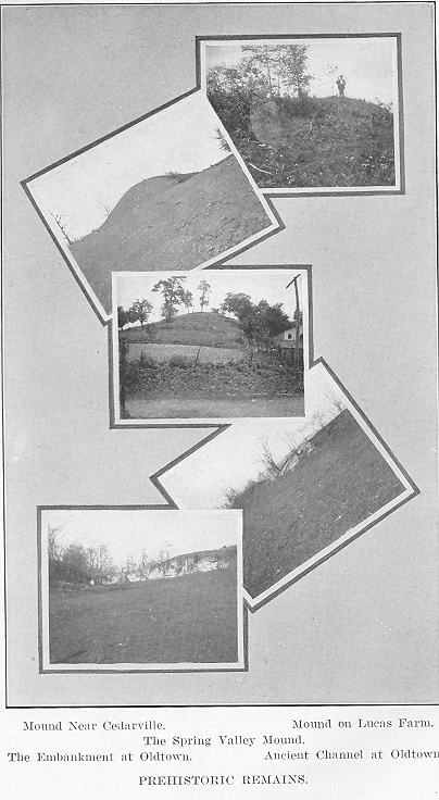
The political history ot unio can not be dismissed without reference to the amendments incorporated in the new constitution in 1912 which have made the constitution practically a new instrument of government. The general tendency of the thirty-three amendments is to make a free expression of democracy through the medium of the initiative and referendum, direct primaries and home rule for cities. A workmen's compensation law was enacted which provides for compulsory contributions to an insurance fund by the employers of the state. Many changes were made in providing for improvements in social and industrial conditions. Ohio now has a con-stitution which is sufficiently flexible to allow changes to be made by amend-ment without the trouble of a constitutional convention. BOUNDARY LINES. The state boundaries of Ohio have been the cause for most animated discussions, not only in regard to state limits but county and township lines as well. In 1817, and again in 1834., a severe controversy arose over the boundary between Ohio and Michigan which was settled only after violent demonstrations and government interference. In primitive times the geographical position, extent and surface diversities were but meagerly comprehended. In truth, it may be asserted that they could not have been more at variance with actual facts had they been laid out "haphazard." The Ordinance of 1787 represented Lake Michigan far north of its real position, and even as late as 1812 its size and location had not been definitely ascertained. During that year Amos Spafford addressed a clear, comprehensive letter to the governor of Ohio relative to the boundary lines between Michigan and Ohio. Several lines of survey were laid out as the first course, but either Michigan or Ohio expressed disapproval in every case. This dispute came to a climax in 1835 when the party beginning a "permanent" survey began at the northwest corner of the state and was attacked by a force of Michigan settlers who sent them away badly routed and beaten. No effort was made to return to the work until the state and various parties had weighed the subject, and finally the interposition of the government became necessary. A settlement resulted in the establish-ment of the present boundary line between the two states, Michigan being pacified with the grant of a large tract in the northern peninsula. 58 - GREENE COUNTY, OHIO Ohio is situated between the 38̊ 25' and 42̊ north latitude, and 80̊ 30' and 84̊ 50' west longitude from Greenwich, or 3̊ 30' and 7̊ 50' west from Washington. From north to south it extends over two hundred and ten miles, and from east to west two hundred and twenty miles—comprising thirty-nine thousand nine hundred and sixty-four square miles. The state is generally higher than the Ohio river. In the southern counties the surface is greatly diversified by the inequalities produced by the excavating power of the Ohio river and its tributaries. The greater portion of the state was originally covered with timber, although in the central and northwestern sections some prairies were found. The crest or watershed between the waters of Lake Erie and those of the Ohio is less elevated than in New York or Pennsylvania. Sailing upon the Ohio the country appears to be mountainous, bluffs rising to the height of two hundred and fifty to six hundred feet above the bed of the river. Ascending the tributaries of the Ohio, these precipitous hills gradually lessen until they are resolved into gentle undulations and toward the sources of these streams the land becomes low and level. Although Ohio has no inland lakes of importance, it possesses a favorable river system which gives the state a convenient water transportation. The lake on the northern boundary, and the Ohio river on the south afford convenient outlets by water to important points. The means of communication and transportation are superior in every respect, and are constantly being increased by railroad and electric lines. CHAPTER II. TOPOGRAPHY AND GEOLOGY OF GREENE COUNTY. Greene county is located in the southwestern portion of the state of Ohio and is bounded on the north by Clark, on the east by Madison and Fayette, on the south by Clinton and Warren, and on the west by Montgomery county. The principal topographical or surface features of Greene county are the valleys of the Little Miami river and of Beaver creek. Caesars creek also forms a depression of considerable importance in the southeastern townships. To these three valleys all the drainage of the county is directed, with the exception of that of Bath township in the northwest corner, which lies within the valley of Mad river. Even though Beaver creek is a much smaller stream than the Little Miami, its valley is a much wider and deeper trough. However, the drainage effected by the former stream is insignificant when compared with that of the larger one. Beaver creek is a small, sluggish stream which is almost lost in its wide, fruitful valley, and no one can fail to recognize the disproportion which exists between. the present stream and the valley which contains it. The .truth is that this .wide valley was never excavated by Beaver creek, for it is the deserted channel of an old river which must have had greater force and, greater volume than the Little Miami today. Nor is there any doubt as to the general course and tributaries of the river that did this work, for the valley of Beaver creek connects on the north with the valley of Mad river. Whether the water of the head-springs of Beaver creek shall be delivered to the Little Miami or Mad river depends upon the digging of a ditch or the turning of a furrow. It is interesting to note that a protracted and expensive law suit was formerly decided in the courts of Greene county, where the only question at issue was as to which stream the head-springs of Beaver creek naturally belonged. It can, therefore, be asserted that the valley of Beaver creek is but an extension of the valley of Mad river, and was occupied by that stream at no very remote period. An examination of the geological map of Greene ounty, upon which the alluvial valleys of the county are also indicated, serves to bring out this point very distinctly. In Clark county an- older valley of the great Miami river is shown to exist, connecting its present' valley with that of Mad river, thus the confluence of these streams. was effected below Springfield instead of at Dayton as at 60 - GREENE COUNTY, OHIO present. It then seems probable that the valley of Beaver creek was formerly occupied by the waters of the Great Miami after it had been re-enforced by the whole volume of Mad river. With such an origin the present dimensions of the valley are easily understood. FEATURES OF THE LITTLE MIAMI VALLEY. The valley of the Little Miami in Greene county consists of two well-marked portions, the lower one of which has been cut out of the shales and limestones of the soft Cincinnati series, while the upper portion of the river has been obliged to erode its way through the massive courses of cliff limestone. The lower valley is therefore deep and capacious, while the upper one consists of a narrow gorge bounded by precipitous walls. The first of the above-named divisions constitutes one of the most valuable agricultural sections of the county, and the second, which has no such economic applications aside from water power, which has not been utilized to any great extent, furnishes the most picturesque and attractive scenery, not only of the county, but of all the surrounding region. There is but one point in all southwestern Ohio where more striking scenery is furnished than that of the gorge of the Little Miami between Grinnells Mills and Clifton. The limestone is cut to a depth of from sixty to eighty feet, and the valley never exceeds a few hundred feet in width. At Clifton the forge is contracted to a score or two of feet and it is in some places four times as deep as it is wide. Several of the more prominent tributaries of the river have scenic features similar to the main stream. The valley of Massies creek below Cedarville is almost as picturesque and striking as that of the Little Miami at Clifton. Clarks run, near the southern line of Miami township, shows another of these deep gorges, and the beautiful glen at Yellow Springs, which has had precisely such an origin, is known to thousands of people. There remains one other valley of less importance, that of Caesars creek, which is a much shallower trough than those already described. Its upper branches occupy slight depressions in the drift beds which so deeply cover the eastern side of the county. At the western margin of the cliff limestone the creek is bedded in rock but it has not cut out a deep channel for itself. PRESENCE OF CLIFF LIMESTONE. By reference to the geological map it will be seen that the northern and eastern portions of the county are underlaid by cliff limestone, and from the western half, though originally present, this formation has been carried away by long continued erosion, leaving only isolated patches of it to attest its former extent. The occasional summits in the western part of the county, that are one thousand or more feet above sea level, are in all cases outlying GREENE COUNTY, OHIO - 61 portions of cliff limestone. By the removal of the protecting layer of cliff limestone, the softer beds of the Cincinnati series have been uncovered, and the waste and wear in them has been much more rapid than in the higher rocks. The deposits of the drift have been spread all over the county, reducing the ruggedness of the surface and hiding many ancient channels, but this did not, of course, change the underlying geological structure. Hence here, as in other counties, a geological map becomes to a great degree a topographical map. The areas of cliff limestone comprise those districts of the county which rise above one thousand feet above the sea, while all the other regions belong to the Cincinnati or softer stone areas. ELEVATION. The lowest land of the county is found on its southern boundary, in the valley of the Little Miami, and ranges between two hundred and seventy-five and three hundred feet above low water at Cincinnati, or between seven hundred and seven hundred and twenty-five feet above sea level. The highest land is found in Cedarville and Miami townships, along the watersheds between the Little Miami and Massies creek and the Little Miami and Mad river. This high region may be safely estimated to be not less than six hundred and fifty feet above Cincinnati or eleven hundred feet above the sea. There is but little difference between the elevation of these dividing ridges. The summits of each consist of stratified beds of sand and gravel belonging to the last stage of the drift period. The highest elevation held by the bedded rock is probably in Miami township, to the north and northwest of Yellow Springs. The following elevations of a few of the principal points in the -county, most of which were determined by Franklin C. Hill many years ago, are all counted above low water at Cincinnati, which is four hundred and thirty-two feet above the sea. The elevation at the grade at the railroad depot in Xenia, 491 feet; Yellow Springs, grade of railroad at depot, 541 feet; Osborne, grade of railroad at depot, 410 feet ; Spring Valley, grade of railroad at depot, 333 feet ; Claysville, grade of railroad at depot, 321 feet ; Harbine's Station, grade of railroad at depot, 370 feet; Oldtown, grade of railroad at depot, 396 feet ; Goes Station, grade of railroad at depot, 427 feet; Berryhills Hill, Spring Valley township, 560 feet; Shoups quarry, two miles southwest of Harbines, 519 feet; gravel bank, Yellow Springs, about 625 feet; railroad grade, one mile north of Yellow Springs (north line of the county) about b00 feet; Cedarville, railroad grade, ab0ut 550 feet. 62 - GREENE COUNTY, OHIO GEOLOGICAL SERIES. How wonderfully Nature conceals her inconceivable antiquity tinder roses, violets and morning dew ! On taking a pleasant walk over the country roads, through the woods and over the hills, does the pedestrian realize that the rocky cliffs and the very soil are countless centuries old. Geologically speaking, we do not measure the age of the earth by years but by series. Each series represents a certain deposit of limestone, fossils, clay or shale which has been left on the surface in some distant age of the past, and by these series we can gain some idea of the animal and plant life thousands of years ago. These series may be compared to the annular rings in the trunk of a tree, by which we are enabled to approximate the age of any monarch of the forest. The rock formations in geological scale of Greene county are confined to the two great series, those of the upper and lower Silurian ages, and between them the county is almost equally divided. If it were possible for one to take a gigantic saw and make a cross section of the rocks of Greene county, it would be found that they were divided into the three following layers : At the surface, the Niagara group, which acquires its name from the falls of that name where this stone is in great evidence ; the Clinton limestone, and the Cincinnati series, Lebanon division. The lowest division has an aggregate thickness of two hundred and fifty feet, the middle one, of fifty feet, and the upper one, of one hundred and twenty-five feet; hence the total section of rocks in the county is four hundred and twenty-five feet in thickness. THE GORGE OF THE LITTLE MIAMI. Since it is not possible to make such a cross section of the rock deposits of Greene county in a convenient manner as suggested above, it is necessary to go where nature has made such a cleft, and there is no better place to study the same geological strata in the state than in the gorge of the Little Miami between Goes and Clifton. At the former place, the river is bedded in the limestones and shales of the Cincinnati series, and at least fifty feet of this formation can be found on the western side of the valley. Moreover, the streams from the uplands have their channels in the rock, hence they give ample opportunity for the study of geologic formations. In addition to these, the Xenia pike, what was formerly the Little Miami railroad and the race for the powder mills have all required rock cuttings, hence these improvements lay bare some of the geologic secrets of Greene county. The termination of the Cincinnati series is very distinctly shown in a ravine just south of the old Goe residence, and. this may be considered a typical locality, for it is from this point that the place where the upper and lower GREENE COUNTY, OHIO - 63 Silurian formations can be traced. At this place, between the fossil-bearing beds of the Cincinnati group and the overlying Clinton limestone, there occurs a layer of fine grained shales, light blue and red, destitute of fossils, some twenty feet in thickness. The shale layer occupies the place held by the Medina group in other places in the state, and it has been suggested that the shales represent this formation. This evidently is not true, for in many places in the county the Clinton limestone rests directly, upon the Cincinnati series. At the place mentioned above may be found an excellent example of the Clinton limestone in a wall of rock which overhangs the shale layer, and this same limestone can also be seen in the cliffs along the river valley near the old Grinnell mill. 'The artificial sections which were made in the old Yellow Springs quarry make, on the whole, the best point in the county where the Niagara group may be studied. THE CINCINNATI SERIES. The uppermost two hundred and fifty feet of the Lebanon division of the Cincinnati series underlies the western half of Greene county, which area comprises the more eroded portions of the county. Since the layer lies very low, it is for the most part heavily covered with the drift deposits. There are, however, many places where the rock is exposed, especially in Spring Valley and Sugarcreek townships, where the series can be studied to excellent advantage. In the valley of Bear branch, a tributary of the Little Miami, a considerable layer of this formation is shown. The line of demarcation between the upper and lower Silurian formations is shown as distinctly in Greene county as any other place in the state. Another especially good point for the study of this formation is in Spring Valley township, on Caesars creek, where it crosses the Xenia and Wilmington turnpike; and also in the vicinity of Reeds hill in Bath township. As elsewhere in southwestern Ohio,. points where the upper and lower Silurian strata are exposed are marked by many springs. The stone of the Cincinnati series in Greene county is not of very much economic importance, for the building stone it furnishes is only of a fair quality. THE CLINTON LIMESTONE. There are several places in Greene county where the Clinton limestone can be studied to advantage.. In addition to the fine displays near the old Goe place, it is also in evidence on the Grinnell pike. It is also well shown in Xenia township in the banks of Oldtown run and Massies creek and again near the head springs of Ludlow creek. In Bath township there are miles of its outcrops where the whole formation can be seen with the greatest pos- 64 - GREENE COUNTY, OHIO sible distinctness. Reeds hill, which may be mentioned in this connection, is a promontory of cliff limestone, overlooking the fruitful valleys of Mad river and Beaver creek, and from its summit can be seen one of the most beautiful landscapes of southwestern Ohio. The Clinton limestone at all these points, as elsewhere, is mainly a semi-crystalline limestone, whose bedding is uneven and interrupted with lenticular, or knob-like masses. A course can seldom be followed for twenty feet and within this distance it is sure to terminate in a feather edge. The more common colors of the formation in Greene county are light gray, yellow and pinkish, the latter tint being the more common one. Its crystalline character is so pronounced that much of the formation may be counted true marble, admitting of a high polish. When some of the red varieties are selected, it makes a highly ornamental stone, the sections of the white crinoidal stems giving a beautiful relief to the dark background. The stone, however, is of no great commercial value on account of its uneven bedding. The base of the Clinton limestone, or rather the summit of the Cincinnati series, is an excellent water carrier, as is shown by the line of fine springs which mark the meeting point of the two strata, whenever drainage conditions will admit. The lower beds of the formation are sandy in texture and at many points are porous and easy to crumble; hence the beds are easily cut by the action of underground streams, and small caves frequently occur at the base of the series. In other cases sink-holes are formed from the same general cause. By the dissolving of the rocks along the divisional planes which separate them, streams on the surface can find access to the shales of the Cincinnati series beneath, hence streams of small volume sometimes drop out of sight to emerge again along the outcrops of the formation perhaps miles from the point of descent. One of the best known of these sink-holes in Greene county is found near the intersection of the Xenia and Fairfield and the Dayton and Yellow Springs pikes. The stream that here drops out of sight comes out again a mile or more to the southward, re-enforced, perhaps, by the underground rills, and forms the head spring of Ludlow creek, one of the finest fountains of the county. These sinkholes have been sometimes deserted by the water courses that have helped to make them, and many times these indented places in the surface have been called abandoned lead mines. Formerly, some portions of the county were full of traditions about lead mines which the Indians worked here. In the early period of the county's settlement, the Clinton limestone served a rather important economic use as building stone, but since it occurs near the Niagara series, which yields excellent building material, it gradually fell into disuse. In earlier times the accessibility of the Clinton beds caused them to be largely drawn upon. In a like manner, the making of GREENE COUNTY, OHIO - 65 lime from the Clinton stone was abandoned. For many years the outcrops of the stratum at Reeds hill supplied the Mad river valley and the western side of the county largely with lime, and about a half century ago lime was also made from the Clinton stone in Xenia township. The opening up of the Niagara beds caused the Clinton limestone to be abandoned for this purpose, since the former can be more cheaply worked and the quality of the lime is better. THE NIAGARA SERIES. The Niagara series is the most important rock formation in the county for two reasons. In the first place, it occupies a somewhat greater area than the Cincinnati group, and in the second place, it more distinctly forms the features of the district in which it occurs than does the Cincinnati formation. It has been shown before that many of the more noticeable topographical features of the surface of the county are traceable to cliff limestone of which the Niagara is the leading constituent. Its outcrop is a rocky wall, very often uncovered and quite precipitous, and at least one hundred feet above the surrounding country. The picturesque gorge of the Little Miami and its tributaries are due to the order of the layers of this series, which also has an important bearing upon the water supply of the entire county. The building stone and the lime of the county were almost wholly obtained from the stone of this series, and in addition to the home supply, large quantities were formerly shipped to the neighboring cities and towns. The divisions of the Niagara group are well marked, and several of the individual members are of greater importance than the Clinton limestone. These members are the Guelph or Cedarville beds, the Springfield beds, the West Union beds, the Niagara shale and the Dayton stone. DAYTON LIMESTONE. The Dayton limestone, which forms, wherever it occurs, the base of the Niagara series, is found in considerable quantity in Greene county. On the western border of the county, it is found capping the cliff limestone that lies southwest from Harbines in Beavercreek township. Owing to the fact that greater and more accessible deposits are to be found in the Dayton district, these beds have been little developed. The stone, as found here, has all the characteristics of the formation in thickness, regularity, durability and color, but its durability is somewhat lessened by the presence of crystals of an iron compound, which weather on exposure and disfigure the surface of the stone. By far the best known deposit of the Dayton limestone found in the county is on the old McDonald farm which lies three and one-half miles south of (5) 66 - GREENE COUNTY, OHIO Xenia. This stone was first found here exposed along a tributary of Caesars creek, and when the quarries were first opened, the stone was covered only lightly by a covering of boulder clay. As the lines have become more extended, the stripping has become more difficult. From four to five feet of workable stone is found here, divided into courses varying from four to twenty inches in thickness. Formerly this stone, before the extended use of concrete, found a market in Xenia as building stone and much of it was shipped from that point by railroad. NIAGARA SHALE. The Niagara shale which directly overlies the Dayton limestone where the latter stratum is found, sometimes occurs over the Clinton limestone where the Dayton stone is lacking. The Niagara shale, of which eighty-five feet are found at the Niagara Falls, has its maximum development in Greene county in the glen at Yellow Springs, where it attains a thickness of thirty feet. The composition of the shale is not uniform and the two elements thereof—the light blue and the thin bedded, yellowish limestone shale—are found in varying portions in different sections. In addition to these two constituents of the Niagara shale in Greene county, there occur occasionally numerous crystals and lumps of an iron compound. These little lumps of iron compound, which are found in more or less large numbers near Yellow Springs, have been often construed by the early settlers of this county as indicating mineral treasures in the rocks where they abound. Years ago there was a pit near the mouth of the Cascade branch, six feet in diameter and twenty feet in depth, and walled in with timber. The origin of this hole was unknown to the oldest inhabitants, but it would seem to indicate that these little lumps of iron compound had misled some early settler of the county into believing that the sinking of a mining shaft would open up wonderful treasures of iron ore which he believed undoubtedly lay in the rocky strata below. The surface of this shale is a very important water hearer of this region, for it gives rise to numerous excellent springs along its outcrops and supplies the largest number of the drilled wells on the table land. WEST UNION CLIFF STONE. The next division of the Niagara series in ascending order is the West Union cliff stone, which does not occur to any great extent in the county. The cascade at Yellow Springs reveals this formation, the water of the stream falling over it. This stratum overhangs the easily weathered shales and thus makes possible the waterfall. GREENE COUNTY, OHIO - 67 SPRINGFIELD STONE. The Springfield stone, which is the fourth' element in the Niagara series, is, from the economic. standpoint, more important than_ any other stone deposit in the county, for it is the division which furnishes most of the building stone of the, county. This stone has large outcrops in Miami and Cedarville townships. It is much more largely quarried at Yellow Springs than at any other point in the county. However, on Massies creek and its tributaries, west of Cedarville, it has also been rather extensively worked. The section at Yellow Springs is twenty-four feet thick, but not more than twelve feet of it is ordinarily worked. The courses vary in thickness from four to fourteen inches, dimensions which are highly desirable for building purposes. Easily raised and dressed, of convenient thickness and of ample surface, this stone is surpassed by none in the state for rough masonry. The color of it is either blue or drab, the blue frequently weathering to the latter color on the exposed faces of the courses. In this stratum shaly partings are occasionally found. These are' several inches in thickness and occur about eight or ten feet below the surface. This shale, from its impervious nature, is an excellent water bearer: CEDARVILLE LIMESTONE. The Cedarville limestone is the crowning member of the Niagara series in the northern and western portions of a widely extended field, but it is known by different names in different localities, being styled the Guelph bed in Canada, the Racine or Milwaukee in Wisconsin, and the Bridgeport in northern Illinois. In southern. Ohio it is termed the Cedarville bed because of the large quarries which have been opened at that village. There is, however, not as great a thickness of the limestone shown at Cedarville as at Yellow Springs, the latter place being decidedly the best section of the Niagara series in Greene county. Here it may be safely said that the total thickness of the Cedarville bed is not much less than forty feet. The characteristics of this stone in Greene county are quite marked. The lowest ten or twelve feet of the stone consists of solid stone almost without any planes of stratification, and when it is blasted it comes out in large irregular fragments. This, of course, makes it valueless as building stone. It is very light gray in color and the numerous cavities found in it, large and small, are all studded with small crystals of lime. The upper surface is crowned with the casts of fossils, the faces of which are frosted with crystals. The upper portions consist of a very thin bedded and fragile limestone, which is often sandy in texture and light gray or yellow in color. The latter is the predominant color at Yellow Springs, the former at Clifton, while both colors appear at Cedarville. 68 - GREENE COUNTY, OHIO But a single economic application has been made of the Cedarville limestone. The condition in which it is taken out of the quarry makes it unfit for building purposes, but as a source of lime, it is without a rival in the market of southern Ohio. In comparison to the amount of construction work done at the present time, the amount of lime consumed has not kept pace with the general growth and development of the country, because of the extended use of cement. For many years lime in large quantities has been burnt at Yellow Springs and Cedarville. At Cedarville the production in 1874 was as follows: D. S. Ervin, 280 carloads or 85,000 bushels ; Wesley Iliff, 130 carloads or 40,000 bushels; Shrads & Gibney, 130 carloads or 40,000 bushels ; Orr & Son, 75 carloads or 23,000 bushels; Satterfield & Son, 40 carloads or 12,000 bushels. The price for the product in 1874 was fifty-five dollars a carload or eighteen and one-third cents a bushel, but when retailed at the kilns it sold 'for twenty-five cents a bushel. At Yellow Springs, in the same year, thirty thousand bushels of lime were produced and sold at fifty-five dollars a carload, the same as the Cedarville product. The Yellow Springs quarry reached down to the building stone courses, and in the same year five hundred perches of the same were sold at the price of one dollar and seventy-five cents the perch. The Cedarville beds have been instrumental in the forming of the beautiful scenic effect of the gorge of the Little Miami at Clifton. These beds, which are a bluish white in color, overhang the Springfield courses which are very easily weathered because of the shaly partings between them. As the Little Miami wore through the cap rock of Cedarville stone, the gorge was found to be as wide or wider at the bottom as at the top. Then again, as the work of erosion progresses, the cap rock unsupported by the Springfield stone which is worn away with comparative rapidity, tumbles off into the ravine. It is certain that this beautiful valley has been growing in this manner, which we can mark out today, since the Little Miami first wended its way down through its course. THE GLACIAL DRIFT IN GREENE COUNTY. Many, many centuries ago, possibly before the Americas were inhabited by primitive man, the great ice sheet, which was many feet in thickness, moved slowly down from the north until it reached an irregular line in Ohio somewhat north from the Ohio river. As this tremendous mass of ice slipped and ground over the land, it scooped out beds of new lakes, leveled the hills, filled the valleys and cut new river channels. An immense amount of debris was carried along with the ice sheet and when it melted, the boulders and gravel and soil were left in large drifts. The land which many cen- GREENE COUNTY, OHIO - 69 turies after became Greene county was passed over by this immense mass of ice, which left in this section numerous traces of its work here those many thousands of years ago. The materials for an extended study of the drift are spread over the rocky floor of this county. When the ice came grinding over, it polished and planed the surface of the Niagara limestone almost over the entire county ; especially are the marking of the ice noticeable in sections of the county where cliff limestone is exposed. These grooves, which are obvious on the uncovered surface of the Yellow Springs quarry, have a direction in most instances of ten to fifteen degrees west of north. These grooves in the quarry extend in a. general direction which cuts the direction of the "Glen," which is immediately adjoining, at an angle of twenty-five degrees. This shows that even such a deep fissure as the "Glen" had no influence in changing the course of this ponderous juggernaut of ice which ground on and on over the primitive fields of Greene county, literally cutting off the large hills and• filling up the adjacent valleys. Over the polished surface of the rocks, as well as over extensive areas where the stone retains no marking left by the ice, are deposits of varying thickness of boulder clay. This is a mixed-up mass of clay, thickly set with boulders of various sizes and small pebbles. In its original state, the deposit was very compact, but where it is near the surface and subject to the action of the air, the mass has been transformed from the so-called blue clay to yellow. As the years have passed and the pebbles in this clay have been dissolved, the latter has become more porous and permeable for the air, so that it could support some low forms of vegetable life. The unchanged blue clay is often found in wells and along the banks of streams. In the latter place the yellow clay is washed away as rapidly as it is formed by the air. The people of Greene county are indebted to the ice sheet for the beds of clean sand and gravel which occur almost everywhere on the surface of this section, especially on the higher points. These beds are in conspicuous layers, but they differ from those of the boulder clay in that the pebbles are water-washed and they look very much as if they have been sifted and arranged under water. Of the several gravel banks in the county the one at Yellow Springs is deserving of special notice. It is located south of the village, about one-half mile from the railroad tracks. Its altitude rises above the rather flat surrounding country to the height of forty feet, and it embraces an area of about two acres. In addition to the sand and gravel deposits in its composition, there are considerable quantities of clay. However, the last mentioned constituent, as are the others, is quite well separated. Boulders of considerable size are met with in the bank, the largest one being about seven feet in length. It is like almost all the other large 70 - GREENE COUNTY, OHIO sized boulders of southern Ohio in that its composition is largely of gniess, banded with rose-colored feldspar, a crystalline substance. The extensive gravel beds in the county furnish a well-nigh inexhaustible supply of excellent road-making material, and sand and gravel for concrete making in this section. WATER SUPPLY. Of all the natural resources, that of water occupies a most important place, and Greene county is especially well supplied with this free gift of nature. People living in the central west, where the sources and supply of water are not at all stinted, become so familiar with the bountiful supply of "the nectar which Jupiter sips," that they fail to appreciate the great boon which nature has lavished upon her too often unappreciative children. Farmers of the central states do not find it necessary to irrigate their crops and orchards, for a timely shower freshens the atmosphere and the thirsty vegetation and animal life. Cool springs and rippling branches and sweeping rivers flowing onward in their never-ending courses lie in convenient places for the refreshment of man and beast and vegetation. Greene county has an excellent water supply, which, while not quite equal to that of Madison county, the best watered section in the third geological district, yet, on the whole, is much better than that of Clermont, Brown and Hamilton counties. Here a large portion of the water used for man and beast is derived from springs and flowing streams, as well as from artificial wells. There are three prominent horizons of springs in the strata of Greene county, and the lowest of these marks the junction point of the upper and lower Silurian formations. This coming together of the two great layers of rocks makes an admirable place for springs to issue forth. At the top of the lower Silurian' stratum is the broken layer of the Clinton limestone, which forms an, excellent water carrier, and below this is the shale of the Cincinnati group which is so impervious to water that it forms a good floor on which the water can rest. This layer of shale turns the tiny underground stream outward and they appear along the sides of valleys. Two springs which belong to this class are the ones at Goes and at the headwaters of Ludlow creek. SOURCE OF THE FAMOUS YELLOW SPRING. About seventy-five feet higher in the geological scale there occurs another horizon, the summit of the Niagara shales, which make an important contribution to the water supply of southern Ohio. The springs coming from this source, both numerous and important, are confined chiefly to Cedarville and Miami townships. A third water-bearing bed is found about twenty to thirty feet higher than the one mentioned just before. It is a GREENE COUNTY, OHIO - 71 shaly seam in the Springfield division of the Niagara series, but it is of much less importance than the other two. Many of these springs occur in the vicinity of Yellow Springs, of which the most remarkable one is that from which Yellow Springs received its name. Although this spring appears to come from this level, there is reason to believe that it comes from a deeper source, and that its outlet is obstructed at its true horizon. The temperature of this remarkable spring varies little with the season and its volume is little affected by drought. Its water contains in addition to its limestone impurities a large quantity of an iron compound, but the source of this constituent is not known as there is no unusual amount of iron in any of the neighboring rock sections. If the water filters through some large deposit of ocherous gravel, such as the latter stages of the drift produced throughout the country, then an adequate source of the mineral matter in the water would be accounted for. There is room enough in the higher lands for large deposits of this gravel, but none can be pointed out. On the other hand, if this matter is derived from the bedded rock, it is evident that large spaces must be left underground by the removal of this material. Thus with some of the most beautiful scenery to be found in southwestern Ohio, with one of the best sources of water supply to be found in this district, with its excellent natural draining system and with such excellent soil, of which an extended mention will be made in the chapter on agriculture, Greene county may be said to be one of the best in southwestern Ohio. There is no wonder that the noble pioneers cheerfully withstood the privations and hardships connected with the opening up of this wonderful farming section, a vista of which one can behold from the summit of Reeds hill as he looks westward over the valley of Mad river. CHAPTER III. THE MOUND BUILDERS OF GREENE COUNTY. As we are accustomed to consider the West a new country, it is difficult for us to realize that in this section and right here in Greene county there flourished centuries ago a people who achieved a certain degree of civilization. It certainly existed long before the mighty army of Xerxes, the Persian, received its never-to-be-forgotten defeat on the field of Marathon, or when our Anglo-Saxon progenitors, clad in skins and rough armor, made their descent upon the peaceful shores of Britain. The remains of this civilization, if such it may be called in the popular sense, can now be seen scattered along the waterways and valleys of the Mississippi basin. This civilization was that of the Mound Builder. No end of speculation may be indulged in when this race is considered, for the Mound Builder is still a mystery. His story has not yet been told. He is not yet intelligibly tangent to any known race. He is not only prehistoric, but unconnected. His silence is impressive. He is the Pelasgian of the western world. On the other hand, there remains not the least vestige of doubt that the Mound Builder existed, and existed here in Greene county, for he left material remains of his activities in the past ages. But the difficulty arises in the interpreting of his sensations, struggles and aspirations because, with the exception of his mounds and a few crude utensils, he left no record of his existence as did the Egyptians with their hieroglyphics or the Assyrians and their cuneiform writing. Nevertheless, much progress has been made in recent years in the study of this early settler of the West who wandered over what is now Greene county, and much that is valuable has been discovered through the researches of archaeologists. For a century or more the modern settlers of the Mississippi basin have looked with inquiring wonder upon the great fortifications and burial tumuli of the Mound Builders and have collected the stone and flint implements and ornaments of the early denizen of this section. Some scholars who have studied him superficially, have called him "Aztec," "Toltec" and even "Tartar." The recent activities of trained and competent archaeologists have thrown new light upon his habits of living, customs, and grade of culture. EVIDENCES OF THE MOUND BUILDER. The study of the Mound Builder, himself, is largely confined to a
GREENE COUNTY, OHIO - 73 study of his mounds. The large mounds, of which there are twenty-seven in Greene county, still rear their heads along the lowlands and the courses of the Little Miami and Beaver creek, and their builders, whithersoever they may have departed, have left their skeletons in and around these monumental earth-heaps, where they remain today as startling effigies of humanity as at the hour of their deposit. The Mound Builder then lies by the side of his mound, hence he is neither a speculation nor a myth. Whatever may have been his aspirations, his struggles, his empire or his final disappearance, he was a resident of this region, and as real a one as his Anglo-Saxon successor. The Mound Builder interred his dead under two feet of earth at his doorway, his habitation and his graveyard, possibly for lazy convenience's sake, knowing little distinction. Evidently life and death had for him little of the panorama which they have for the civilized being. On opening these sepultures, the forms are found to range from untoothed infancy to toothless old age. However, in general, one-half of the burials are those of infants and children. It seems that these early inhabitants were not very economical with their babies. Scarlet rash, teething and a diet of imperfectly boiled green corn had evidently done their perfect work. From all evidences the Mound Builder was an ardent lover of tobacco, for often by the side of an adult skeleton lies a carved pipe of stone. Here and there, also, among the skeletons lie the spear head, the arrow head, the stone hatchet, or other implements of stone, flint and bone. It is interesting to speculate how long these human remains laid thus until they were rudely disturbed by the spade of the curio hunter and archaeologist. One hundred, two hundred, four hundred years? Longer than that, for the Indian tribes that met our forefathers here in Greene county knew nothing of these burials. Probably six hundred, ten hundred, two thousand years, then—from the days when Caesar fought his successful wars in Gaul against Vercingetorix or the skin-clad ancestors of the civilized Saxon, now exhuming them, fell under the sword of the Celtic Dagobert in the forests by the Rhine. It is extraordinary how long the frame of man. will last. It may be three thousand years, as evidenced by the experience of Schliemann and his Mycenean kings, or five thousand or ten thousand years as instanced by the remains in Thebes and Memphis in upper Egypt. But here in Greene county, at least, still lie the relics of departed races of men, shocking those who rudely disturb them with their mockery of contrast with man's brief stay in the flesh. PROBABLE METHODS OF MOUND BUILDERS. With his mounds, his pots, his implements, his ornaments and his clumsy fortifications, the Mound Builder was not dissimilar in his habits 74 - GREENE COUNTY, OHIO to the Indian who succeeded him. His dwelling sites reveal something of his methods and civilized status. Beyond his primitive implements he wrought neither in wood and stone, and outside of his mounds he was no architect. His home was probably a wigwam of skins and twisted branches. Barring his zealous proclivity for raising mounds, he was only a lazy son of the forest and stream, for the mute testimony revealed by the findings of searchers is against him, even though many in the past have laboriously built up for him a reputation for thrift. He carried his dead only beyond his door yard, and near his habitation he dug circular holes into which he emptied his ash pots, the remnants of his food and the general vestigia of the household. From these have been taken remnants of food, broken and entire implements of stone and bone for household use, shells of the river mussel and land tortoise, flint quirts, fish hooks and arrow heads. The ashes which frequently intervene between sections of the family debris indicate that he cooked his food. Among the implements frequently found are hammers, hatchets, knives, chisels, and wedges of flint and stone; needles fashioned from the delicate bones of birds ; rude cups and ladles made of shells for the purpose of distributing the family soup, and many fragments of earthen pots which indicate a size from two inches to almost as many feet in diameter. The most significant of all the contents of these pits for the family refuse are the varied and almost massive remains of animal life. This indicates that the mound builder was carnivorous. Shells of the river mussel are found almost in heaps, and in many instances the bones of several species of animals are found, including those of the elk, deer, bear, panther, wolf, wildcat, squirrel, rabbit, raccoon, wild turkey, opossum, polecat and dog, all of which apparently were used for subsistence. Withal the Mound Builder did not enjoy the grade of civilization which we like to ascribe to him. It is possible that he carried on a rude form of agriculture ; his weapons were ample for bringing down the largest game of the section in which he lived, and his gigantic barrows and rude fortifications seem to place him alongside the advancement of the early Egyptians, but the ultimate verdict concerning the Mound Builder must needs give him a status which is not so complimentary as many are wont to allow him. Of course, his cranium is not unpromising, and the occasional discovery of a grotesquely carved pipe or ornament may elevate him toward the rank of a Zuni or an Aztec, but it stands to reason that in the light of the discoveries from the tell-tale cavities into which he threw the family refuse, the contents being the indicator of his everyday existence, his status was little better than that of his successor, the Indian. TRACES OF MOUND BUILDERS IN GREENE COUNTY. Even though there are numerous traces of the Mound Builders in |