Of these thirty-four original proprietors of military land in Xenia township a few more than
one-half were veterans of the Revolutionary War ; they were Lieut. Henry Bell, Lieut. Jacob
Brown, Lieut. Charles Bradford, Lieut. Archibald Campbell, Maj. William Croghan, Col.
William Dark, Capt. George Gray, Lieut. George Holland, Col. John Jameson, Col. Richard C.
Anderson, Capt. John Stokes, Maj. William Russell, Capt. Beverley Stubblefield, Maj.
Alexander Parker, Maj. James Knox and Lieut. William McGuire. Moreover, reference to the
first poll-books and the first enumeration sheets of the township and of the townships from which
Xenia. township was erected, reveals that not one of these original proprietors became residents
of the township. The remainder of these original proprietors were either land speculators, who
had purchased the land warrants from the veterans, heirs of the old soldiers or district surveyors
who had found land in the military reservation for which no warrant had been issued.
CONGRESSIONAL LANDS OF THE TOWNSHIP.
Only a small part of the territory of the township falls west of the Little Miami river and is
included in the congressional land of the county. This region comprises the northwestern corner
of the township, on the western bank of the Little Miami. By section, township and range, these
lands are as follows : Fractional sections Nos. 6 and 4 and whole sections No. 5, township 3,
range 8; whole sections Nos. 35 and 36 and fractional sections Nos. 23, 28, 29, 33 and 34,
township 4, range 8. Unfortunately the remainder of the township was not laid out in regular
sections, as is the con-
280 - GREENE COUNTY, OHIO
gressional land, for the irregularity of the military surveys has resulted in many boundary
disputes and attending litigation.
EARLY SETTLERS OF XENIA TOWNSHIP.
The fact that the county seat was established in Xenia township makes the history of the
township center in the county seat. The city of Xenia has contained more than half of the
population of the township for at least a hundred years, and for a number of years it has contained
about one-third the population of the entire county.
So many of the early settlers of the township were residents of the town that there is not much
left to say concerning those who settled in the township outside the town. Again, so many of the
landowners lived in the town that they are identified with the town rather than with the township.
The poll-books and enumeration records which have been cited give the names of all the first
settlers of the township, and it is not necessary to enumerate them again.
Prominent among the early settlers of the town and township might be mentioned the following:
Frederick Bonner, David Laughead, Henry Hypes, the McCoy family, Hugh Andrew, the Gibson
family, John Gregg, the Collins family, Edward Watts, Col. James Morrow, Samuel Goe, James
Butler, Thomas Perkins, Remembrance Williams, the Gowdy family, John Lewis, Bennett
Maxey, Peter Pelham, Isaac Maitland, Major William Beatty, the Galloway family, Thomas
Steele and scores of other families. Most of these concerning whom any definite information has
been preserved are noted in the chapter on the history of Xenia.
THE VILLAGE OF OLDTOWN.
The official history of the village of Oldtown is not very interesting, certainly not as interesting
as the stories which have found a resting place within its now quiet precincts, stories which go
back to the times of the Revolutionary War. A brief statement of the official records of the town,
however, may be set forth here in order to give it a respectable setting in the urban life of the
county.
It was long after it was a village before anyone thought it necessary to plat the site, or take any
steps to set it off from the township in which it was located. In fact, probably its most prosperous
years had already passed when John Jacoby and John Neimsick decided to plat it. These two men
owned the site, or at least, they owned the part that was surveyed, as wit-ness the following
document :
The Town of Old Town [formerly always written as two words] was laid out and surveyed by me
in the Month of March, 1838, for John Jacoby and John Neimsick, Pro-
GREENE COUNTY, OHIO - 281
prietors, on part of a Military Survey on the Little Miami River, originally made for Henry Bell,
No. 359. Sandusky Street, runs North and South and is sixty feet wide. Cross Street runs west
from Sandusky Street, 166 feet on the South line and 191 feet on the North line and is also 6o
feet wide. [The remainder of the document gives the size of the fifteen lots.]
Given under my hand the 26th day of March, A. D. 1838.
MOSES COLLIER, Surveyor G. C.
The history of the town for the past seventy years has been uneventful. It has had a succession of
small merchants who have served the little com-munity, but its proximity to Xenia has made it
impossible for it to grow. At the present time the little hamlet has fewer than two dozen houses,
and there is little likelihood that it will ever be any larger. The one store of the village is owned
by Fred Towes.
CHAPTER XV.
BATH TOWNSHIP.
Bath township was organized by the county commissioners pursuant to an order of that body,
dated March. 3, 1807, the order stating that the first election was to be held at the house of
Andrew Read on April 29, 18437. The township was cut off from Beavercreek township and
originally had much more extensive limits than it has today. The order setting forth the
provisions for the creation of the township, together with its limits, is here reproduced as it
appears on the old records :
Ordered that the Township of Beaver Creek be and the same is hereby divided into two distinct
townships by a line running west with the north Boundary of the 5th [illegible word] of Sections
in 7th Range of Townships between the Miami River. The south division shall retain the name of
Beaver Creek Township, and the first Election Shall be held at the house of Peter Borders in
Beaver Creek Township. The north division Shall be called and known by the name of Bath, and
the first Election Shall be held at the house of Andrew Read, Esq., April 29, 1807.
This ambiguously defined township seems to have included all of the present Bath township, a
small part of Xenia township, most of Miami (certainly to a point east of Yellow Springs), and
all that part of the present Clark county north of Bath and such of Miami as it then included. In
1807 there were just four other townships in the county besides Bath : Beavercreek, Sugarcreek
and Caesarscreek, the three organized in 1803, and Xenia, which had been organized on August
20, 1805. When Miami was cut off from Bath on June 8, 1808, the latter township was left with
its eastern boundary as it is today, that is, so far as Greene county was concerned. But Bath still
continued to include a part of the present Clark county until that county was created in
December, 1817. As Bath township remains today it contains thirty-seven full sections and the
northwest quarter of section 6 in the southeastern corner of the township. This entire township
falls within the congressional township land of the county, and, in fact, is the only town-ship in
the county that contains no Virginia military land.
TOPOGRAPHICAL FEATURES.
The surface of the township is uniformly level, with a few elevations of no consequence scattered
here and there over the township, the most important of these slight elevations being known as
Read's Hill, lying between sections 14 and 5. The township falls into two river basins, Mad river
GREENE COUNTY, OHIO - 283
on the. west and the Little Miami river on the east, although most of the surface is drained into
the latter through Beaver creek. There was formerly a considerable pond immediately east of
Fairfield, but it has disappeared. A number of springs are found scattered over the township and
they are the feeders for the numerous small streams that thread the entire township. The Mad
river basin is very narrow in the township, a fortunate thing considering the proposed change
which is going to befall the township on account of this river. Elsewhere is given in detail how
the Miami Conser-vancy plan is going to change the history of the northwestern part of Bath
township. It is sufficient to state in this connection that when the Huffman retarding basin is
finally installed in the township, it remove from township control about seven thousand
acres—or about eleven square miles. In general terms, this may be defined as all the land west of
the present Ohio electric line, with a narrow strip east of it along the lower part of the line in the
township. It is not now possible to indicate what this will mean to the township, but it can not but
make a great change in things, especially if, as now planned, the village of Osborn is destroyed.
EARLY SETTLERS.
The task of locating the early settlers of Bath township is rendered difficult because of the fact
that the township was a part of Beavercreek township for the first five years of the county's
growth, arid also the fact that the original limits of the township included at least twice as much
terri-tory as the township does today. Hence a number, probably half, of the settlers enumerated
in 1808 did not live within the limits of the township as it stands today with its restricted
boundaries.
It was the custom to enumerate all the inhabitants of a new township as soon as it was organized,
so as to keep a check on the voters. The enumeration in the newly organized township of Bath
was made by David Sleeth. This list includes all the males over the age of twenty-one, the
complete list being as 'follows :
ENUMERATION OF VOTERS IN 1808.
James Andrew, Hugh Andrew, William Anderson, John Anderson, John Adams, Darrow Aims,
Zachariah Archer, Samuel Aldridge, John Blue, Sr., John Blue, Robert Blue, David Blue, John
Black, George Brown, Samuel Brown, Robert Bell, John Burgess, Samuel Butler, Enoch Bot,
Richard Ben-nett, Jacob Beall, John Badley, James Beck, William Barton, Thomas Barnes, John
Buffanbarger, Joshua Bozarth, John Barton, Thomas Baeton, John Botkins, Adam Chambers,
James Chambers, Joseph Carpenter, Christopher, John Carpenter, Isaach Cruzan, Job Clemens,
John Casad, Sr., John Casad,
284 - GREENE COUNTY, OHIO
Jr., Aaron Casad, Jacob Casad, Sr., Jacob Casad, Jr., Samuel Casad, Abraham Classmire, Isaac
Clemens,. John Crumb, John Cromwell, John Galloway, Ezra Clark, John Cox, Josiah Carson,
Dennis Dunn, Benjamin Deever, Mathew Dinsmore, John Driscoll, Robert Davis, Daniel Davis,
Robert Dewitt, George Drummond, Abraham Enlow, William Emmett, Robert Flack, Edward
Flood, Jonathan Flood, Benjamin French, John Forgy, James Forgy, Daniel Foley, Arthur Forbes,
Thomas Fream, William Freal, William Forqueor, Jonas Forqueor, George Foulk, John Goldsby,
Edward Goldsby, William Goldsby, Bridge M. Goldsby, John Goldsby, Sr., James Grimes,
Samuel Grimes, John Grimes, William Gregory, James M. Galloway, David Grummen, James
Grummen, Nimrod Haddix, William Haddix, John Hall, Jacob Hall, Richard Hall, William
Hamilton, Frederick Hosier, Peter Hosier, Ezekiel Hopping, Jeremiah Hopping, Moses Hopping,
David Hopping, George Harner, Charles Hefley, Samuel Hulie, Jacob Harbine, David Humphrey,
James Johnson, Sr., William Johnson, Arthur Johnson, George Kerkendale, Adam Koogler,
Solomon Kershner, Sr., Solomon Kershner, Jr., John Knox, Solomon Kelley, William Lowe,
John Lee, Warton Lampton, Justus Luce, Benjamin Luce, Elisha Ladley, John Lardee, Jacob M.
Marshall, George Minral, Jonathan Mercer, Robert Mercer, James Miller, Benjamin Miller,
Martin Miller, James Miller, Sr., Christopher Miller, Aaron Miller, William Martin, John Martin,
William Mears, Daniel Moore, Richard Moore, Sr., Richard Moore, Jr., John Morgan, Charles
McGuire, John McCullough, William McClure, Mathias McClure, John McKage, Joseph
McCord, Will-iam McKenzie, Joseph McCune, Alexander McNary, Alexander McHugh, Samuel
McKenney, John McPherson, John McGillard, James McDermit, McDermond, John Nelson,
Philip Petro, Nicholas Petro, Paul Petro, William Pasel, Andrew Reid, Jesse Rush, Jacob Rush,
John Rue, John Rouse-grant, Jacob Ryan, David Read, Jacob Rudy, Henry Sidensticker,
Sebastian Shroufe, Sr., Sebastian Shroufe, Jr., Christian Shroufe, Samuel Stewart, John Stewart,
Isaac Stout, John Sleeth, David Sleeth, John Smith, Mathias Smith, William Smith, Spencer
Smith, Thomas Seymour, Samuel Stits, Evers Stevens, Borxeen Stout, George Shannon, Elijah
Stibbins, Francis Sipe, William Stevens, Simon Shover, Samuel Shoup, Jacob Stoker, William
Stoker, Joseph Tatman, James Tatman, Peter Taylor, Joseph Taylor, Isaac Taylor, David Taylor,
Henry Taylor, John Templeton, Joseph Tole, Jacob Trubee, John Trubee, Silas Trowbridge,
-John Tingley, Christopher Trubee, Micajah Tole, Joseph adkins, Richard Wise, Ziba Winget,
Samuel Winget, Reuben Winget, Jacob Wilson, John Wilson, Michael Wilson, Christian
Wil-son, Valentine Wilson, Robert Wolbum, Benjamin Whiteman, Ebenezer Wheeler, George
Wolf, John Wolf, Sr., John Wolf, Jr., Andrew Westfall, Jacob Vandevanter, Peter Vandevanter,
Cornelius Vandevanter.
GREENE COUNTY, OHIO - 285
This list contains the names of two hundred and twenty-six men of voting age, but how many of
them lived within the present limits of Bath township will never be known. It is certain that the
Clifton and Yellow Springs settlers were listed with the Bath township residents, while a
considerable number of them must have lived in what is now Clark county. At the election held
at the house of Andrew Read on April 29, 1807, Read himself was elected justice of peace for the
west half of this extensive town-ship and Thomas Fream was elected to the same office for the
eastern half of the township. It seems that Fream was postmaster at Yellow Springs at this time, a
position that he had held since his first appointment on April 1, 1805. James Miller, also here
enumerated, followed Fream as postmaster at Yellow Springs on October 1, 1810. Again, it may
be noted that another one of the above named voters of Bath, Christopher Shroufe, followed
Miller as postmaster at Yellow Springs on October 1, 1813.
FIRST PERMANENT SETTLERS.
The first settler in Bath township appears to have been well established some years before the
county was even organized in 1803. The year 1800 saw a family by the name of Mercer located
on a tract a mile and a half south of the present village of Osborn. Just when the Mercer family
came from Virginia to the township is not definitely known, but it was a year or two before 1800.
It seems certain that crops were being raised in the township when George Washington was still
living.
Mercer had preempted a large tract at twenty-five cents an acre, his tract including the site of a
large Indian village which had just been deserted only a few years before by the Indians, who, if
tradition is right, had been driven from their village by a band of Kentuckians. The Mercers made
the township their permanent home, one of the most prominent of the family being H. R. Mercer,
who died on June 1, 1873, at the age of seventy.
In 1799 or 1800 there arrived from Kentucky and Virginia a number of families, among whom
were the following : George Wolf, Adam Koogler, John Cox and William 'Wilson. The first
child born in the township was Benjamin Wolf, whose birth is recorded in 1800. The settlers
recorded in list of those of voting age in 1808 came largely from Kentucky and Virginia, but it is
impossible to trace the sequence of their settlement in the township. It is known, however, that by
the time of the opening of the War of 1812 that the township was fairly well settled. During the
first decade of the past century there came into the township William, Adam and John Chambers,
John and Robert Kirkwood, Nimrod Haddix, James and Joseph Tatman, Robert Frakes and
Abraham Huffer. It is not certain that all of these men were living in the present limits of the
township, but
286 - GREENE COUNTY, OHIO
most of them were; all have been credited to the township as it now stands.
William Stevenson, Sr., came from Kentucky with his wife and family in 1803 and located a mile
and a half east of the present town of Osborn. He had four sons : William, James, Peter and John,
the first named being a soldier in the War of 1812. William Stevenson, Sr., died November 1,
1834. There was a large number of the Stevensons in the early history of Bath township, and their
descendants are still living in the township.
The Hosier family came from Shenandoah county, Virginia, in 1803, and located on a tract
between the present village of Osborn and Fairfield. John Hunt had preempted the land, but
Jacob Hosier bought the preemption rights of Hunt for twenty-five cents an acre and paid the
government two dollars an acre for the land. At that time there was one lonely cabin on the site of
the village of Fairfield. In 1819, John Hosier, one of the sons of Frederick Hosier, married Mary
Haddix, a daughter of Nimrod Haddix, one of the most prominent of the first settlers of the
township. John Hosier died on December 24, 1869, at the age of eighty-one and is buried at
Fairfield. Most of the other members of the Hosier family located in Beavercreek township.
Nimrod Haddix, Sr., came to Bath township in 1803 to make his permanent home and lived there
until he was accidentally killed in 1820 by falling from a load of hay. His son, John, coming in at
the same time, died on March 29, 1884, at the age of ninety-seven, and is buried in the Cox
cemetery in Bath township. Many- interesting stories are related about Nimrod Haddix.
SOME SIDELIGHTS ON THE TOWNSHIP.
Every township collects narratives of incidents of interest during the course of a century and Bath
has its full share. Some are true, some not, and others combine both fictional and factual features,
but all of them have a certain interest to those who call this township their home.
A Murder Story.—About the year 1809 sums of money were stolen on the same night from the
homes of John Wolf and Dr. John G. Folck, the first robberies of any consequence in the
township. About the same time a peddler was robbed and .his murdered body thrown into a well
nearby. The three robberies were apparently the work of the same party or parties. A number of
persons were suspected of the robberies and murder, and finally a man by the name of Kent was
arrested on general grounds. It was not possible at the time to fix the crimes on him, but while he
was in jail he managed to make his escape through the efficient assistance of a two-inch auger.
He was never apprehended, but, so the story goes, he was seen in Canada a number of years later
by one of the residents of Bath township
GREENE COUNTY, OHIO - 287
who knew him. Kent informed this man that he could make some startling revelations if he so
felt disposed, but it seems that he was not so disposed. Although it was generally supposed that
he was connected with the robberies and murder, yet nothing more was done about the matter.
TRANSPORTATION.
Mad river runs across the northwestern corner of Bath township, and in the early days of the
county's history it was sometimes used to carry produce down the river. This was done especially
in the spring of the year, when there was an abundance of water, but it is probable that little
trafficking was ever done up the river. The first settlers cut out bridle paths through the woods,
but it was at least twenty years after Mercer came to the town-ship before they had any paths
which might be dignified by the name of roads. One exception to this statement must be made in
the case of the road which ran through the township connecting Dayton and Springfield. From
early days the road between these two cities led through Bath township, and today this is one of
the fine roads of the county, the road being what is known as an inter-county highway. The '50s
saw the first railroad through the township, the Mad River line, and this made a great change in
the growth of the township. The township now has two steam roads and one electric line running
through the Mad river valley, all three lines passing through the village of Osborn, and the
electric line through Fairfield. However, it now appears that both steam roads will be changed
and run east of Fairfield about half a mile east of the town.
TYLERSVILLE, NOW KNOWN AS BYRON.
On May 19, 1841, in the days of John Tyler, William Sensiman had recorded a town bearing the
name of Tylersville, located in Bath township, on the northwest quarter of section 12. The plot
contained 7.38 acres divided into twenty-five lots, 50 by 19472 feet, the lots being stretched in a
row along the north side of the road running between Yellow Springs and Dayton.
There has been a store of some kind at Byron since the beginning of its existence, but it is
practically impossible to trace its shifting ownership. One of the best remembered of the old-time
store-keepers—the title of all the merchants of the place—was the late Mitchell J. Ennis, who
began business here in May, 1861, and continued to deal in postage stamps, sugar, calico and
other commodities from that time until his death in 1887. As near as can be determined Ennis
first became identified with Byron shortly after the place was platted in 1841 ; it may have even
been during the course of that year. He had learned the saddlery trade as a youth and in the fore
part of the '40s located his shop at Byron, then called Tylersville, and for
288 - GREENE COUNTY, OHIO
eight years made harness and did all kinds of leather work for the community. He then began
clerking in the one store of the place, the store being owned by the firm of Shaner & Wilson, who
were probably the first merchants in the place, and the next decade found Ennis clerking in the
village store. It passed from the hands of Shaner & Wilson to Folkerth & Son, and from the latter
to Wolf & Son. It appears that Ennis bought out Wolf & Son in May, 1861 ; at least, he secured
the store in that year and from that time until his death on September 11, 1887, he combined the
duties of postmaster with his mercantile business. He had been born in Sugarcreek township on
April 30, 1818, and was therefore sixty-eight years of age at the time of his death. He never
married. He was a Mason and Oddfellow and had held all the chairs in both lodges. For nearly
half a century he was a prominent figure in the life of his community.
It is probable that the first blacksmith at Byron was Jacob Griner, and it seems certain that he was
located there several years before the town was platted. William Wilson entered his shop as an
apprentice and after three years in the shop, spent one year traveling as a journeyman blacksmith,
after which he returned to Byron and bought the shop and tools of Griner. For eighteen years he
kept the shop, selling it in order to locate on a farm which he had bought. He farmed for a
number of years and in 1872 he removed to Fairfield, where he died on December 4, 1881.
Griner died at Dayton on January 1, 1882, and is buried at Fairfield. Guy Lindamood has been
located at the village for a number of years with a blacksmith shop. Julius Wilson is the
proprietor of the only store in the place, having succeeded Charles Watt, who had been there
several years. There are now about twenty-five persons living in the little hamlet.
MIAMI CONSERVANCY DISTRICT OF BATH TOWNSHIP.
The latter part of March, 1913, witnessed the most devastating flood in the valley of the Great
Miami river basin within its history. While this flood caused comparatively little damage in
Greene county, yet as a result of this flood a comprehensive scheme to prevent the recurrence of
such a disaster has been planned which, when completed, will include a part of the county.
Therefore, in this present history of Greene county it is necessary to discuss this scheme in so far
as it relates to the county.
A brief account of the flood is apropos. The rainfall began on March 23, 1913, and continued
until March 25, during which time there was an average precipitation of 8.8 inches over the basin
of the Great Miami river. The net result of this unprecedented rainfall was an enormous loss of
life, property and land values. It is known that three hundred and sixty-one people lost their lives,
and there are others who were never accounted for.
GREENE COUNTY, OHIO - 289
There were also thirty-two commitments to the insane hospital, each case being specifically
attributed to the horrors attendant on the flood. The property loss has been estimated at
$67,383,574, an amount which does not include the depreciation of land and property values
because of subsequent conditions arising from the flood. Of this staggering amount the loss at
Dayton alone is set forth at $47,254,200 and that of Hamilton and Butler county at $9,568,224.
The Big Four Railroad estimated its loss at $1,250,000; the Cincinnati, Hamilton & Dayton at
$1,000,000; the Erie Railroad at $25,000; various electric lines at $2,000,000.
Before the flood had fairly subsided plans were begun to make a study of the Great Miami basin
with a view to preventing the recurrence of such a catastrophe in the future. It is not necessary in
this connection to enter into a discussion of all the schemes proposed; but for the purpose at
hand, it may be stated that it was finally decided to build a number of so called retarding
basins—five in number—which were to act in the nature of reservoirs, and in that way place such
a check on the flow of water as to prevent devastating floods.
In order to get the situation into a tangible shape so as to proceed, the General Assembly of the
state passed an act on February 6, 1914, cited as "Conservancy Act of Ohio," and under this act
all the work has been planned and will be carried through to completion. The cost of the
undertaking has been estimated from ten to twenty millions, the cost to fall upon the benefited
property owners.
THE HUFFMAN RETARDING BASIN.
The basin of the Great Miami river includes only one entire county—Miami—but it includes
practically all of Montgomery, Preble, Butler, Darke, Shelby, Logan, Champaign and Clark, with
portions of Hamilton, Warren, Mercer, Auglaize, Hardin and Greene. All of Greene county in the
basin lies in Bath township, in the extreme northwestern corner of the county. As has been stated,
the plan as now outlined provided for five retarding basins : Lockington, in Shelby county;
Englewood and Taylorsville, largely in Miami county, but reaching down into Montgomery
county; Huffman in Greene county, backing up slightly into Clark county, and lastly, the
Germantown retarding basin in Preble and Montgomery counties. Of these basins, the
Taylorsville is the largest (1,133 square miles) and the Huffman next in size (671 square miles)
This discussion is concerned only with the Huffman retarding basin, taking its name from
Huffman's mill on Mad river in Bath township. The scheme contemplates the taking over of
approximately 7,324 acres of land
(19)
290 - GREENE COUNTY, OHIO
in the township, the condemned tract including the town of Osborn. The head of the retarding
basin will be covered by a dam 3,340 feet long, the top of which will be at an elevation of 850
feet. The dam will occupy parts of the southwest and northwest quarter of sections 7 and 8. At an
elevations of 785 feet, which is the average surface elevation of the valley at the point where the
dam is to be built, the dam will be 38o feet thick.
The construction of the dam will require the relocation of the Spring-field pike, the Ohio electric
railway, and the Big Four railroad on the south side of the valley, and of the Valley pike and the
Erie railroad on the north side. The concrete spillway weir will be located on solid rock near the
Mad river channel on the south side of the valley. Through the base of this structure will pass the
three equal horseshoe-shaped outlet conduits. The entrances to these conduits will be rounded so
as to facilitate the flow of water as much as possible; and the conduits will empty through
carefully tapered channels into a single combined passageway leading back to the river bed.
FATE OF TWO VILLAGES AT STAKE.
The question naturally arises here—what is to become of the two towns of Fairfield and Osborn
in Bath township? It is not yet definitely decided, but it seems certain that the town of Fairfield
will be practically unaffected. It lies at the extreme eastern edge of the basin in section 27, and, as
originally planned, could have had perfect protection by the construction of a levee on the west
side of the town. However, the residents and property holders, rather than have to bear the
expense of the levee, agreed to accept such damages as might fall on them in case they were
invaded by a flood. It now seems that the town will not be protected by a levee.
The case of Osborn is quite different. The town lies about three miles northeast of the dam, a
distance which under ordinary floods renders it practically immune from danger. However, in
case of a flood of extreme height the water may back up into the town to varying depths, but not
to exceed nine feet. For this reason it appears that the town will be doomed and have to be
condemned.
At the present time it is impossible to estimate with any degree of accuracy the amount of money
it will take to pay for the condemned land in Bath township. The nearest estimate that has been
made by the conservancy board of the value of land in the township which it will be necessary to
purchase—and exclusive of the town of Osborn—is $1,500,000. It will cost practically the same
amount to purchase the town. It means a complete change in the northwest corner of Bath
township, a change that only future developments will be able to realize.
GREENE COUNTY, OHIO - 291
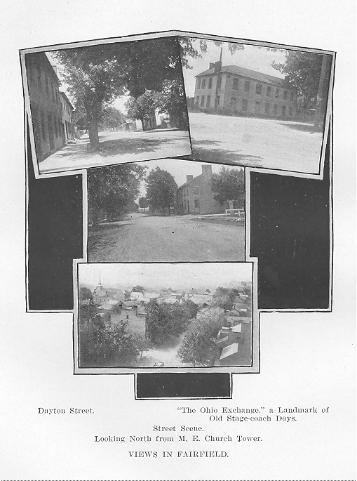
FAIRFIELD.
The village of Fairfield is the third oldest village in the county according to the plat records on
file in the recorder's office, its plat bearing the date of March 12, 1816. The proprietors of the
town were Joseph Tatman, Samuel Casad and William Casad, the latter two being brothers, and
all three men among the earliest settlers in the township. The village was laid out on the main
road between Springfield and Dayton, this being the determining factor in its location. The town
is one of the few in the county that was originally laid out "square with the world," its streets
being laid out due north and south and east and west. There were one hundred and fifty-one lots
in the original plat and it has never been necessary to make any additions to the town to take care
of the increased population. It never had a chance to be anything more than a mere hamlet after
the Mad River railroad went through the township and missed it by a mile. The subsequent
establishment of the town of Osborn on the railroad, a mile from Fairfield, completely dashed
whatever hopes the people of Fairfield may have entertained as to the future of their village.
But time brings great changes. It is an ill wind that brings no good to someone or something.
While it is yet too early to tell what is going to happen, there is now every indication that the
March flood of 1913 is going to mean a new Fairfield. The building of the great Huffman
retarding basin is going to bring about a change in the location of the tracks of the two railroads
through the township, the obliteration of the town of Osborn—and, as it appears at this writing,
the rejuvenation of the town of Fairfield. As now planned the two steam roads will be relocated
so as to pass east of Fairfield, the electric line already going through the village, and the town
will soon be as thriving a place of business as its unfortunate sister town. The town is enjoying a
boom (spring of 1918), more lots are being sold, more civic energy is now manifest than at any
time since the first railroad ran through the township on New Year's Day, 185o. The next history
of the county will Undoubtedly have an interesting story to tell of the rebirth of Fairfield, but the
present historian can only give a hint as to what this story may be.
Little is known of the early history of the town of Fairfield. The hundred years which have
elapsed since the village was first laid out have seen a succession of business enterprises come
and go; a succession of physicians; a succession of artisans of all kinds ; a succession of citizens
who have been glad to call it their home. Its history has not been unlike that of a thousand other
towns of the same size scattered over the great Middle West of our country. It has had its ups and
downs, its lean years, and its fat years, but through the century of its existence it has quietly gone
on its
292 - GREENE COUNTY, OHIO
way, never pretending to be anything more than a village, never assuming any metropolitan airs.
It has had its schools and its churches and these have faithfully performed their respective
functions to the end that education and religion might be diffused among its people. And thus has
it lived for a century.
SOME EARLY HISTORY OF FAIRFIELD.
All of the early history of Fairfield which is here presented was prepared by Mrs. A. L. Shuey for
a special edition of the Osborn Local, July 4, 1895, and the historian is glad to give her credit for
preserving much valuable data which would otherwise have been lost forever.
The first dry-goods and grocery store was opened by Daniel Shoup in 1832. The first school
house made its appearance in 1829 ; the first flour-mill was erected and operated by a man of the
name of Crawford, the millwright being Madison Dryden; the first blacksmiths were William
Hinkle and Reuben Casad. The first hotel was opened by Elisha Searls, the date not known,
although it is certain that Stephen Reader had a hotel here as early as 1831. In fact, it is stated
that there were three hotels in operation in the '30s. Another of the proprietors was Adam
Compton.
Jesse Ragan was an early wagon-maker, his shop being in a large double log house. Conrad
Curtis was a cabinet-maker and funeral director, and had the first turning-lathe in the town.
Joseph Light was a grocer of the '30s and '40s, later adding a tin-shop to his grocery. Peter
Keplinger succeeded him in the business. Other business men of the ante-bellum days included
the following: Joseph Deveres and Charles Cummins, tanners; John Louk, Abraham Brake,
Henry R. Musser and a man of the name of Holloway, butchers; Joseph Cohen, Louis McCarty
and J. D. Bacon, tailors ; Robert Wilkinson, Filbert Bacon and one Wiferd, shoemakers ;
Jonathan Coalston, Joseph Coalston, John Griner and William Snediker, carpenters ; Elias Cord
and Arthur Coffield, coopers ; John and Peter Stull, plasterers; _______ Ginger, gunsmith ;
______ Selma, stonecutter; Joseph Kneisley, blacksmith.
Dr. Randolph R. Greene and Doctor Rush constructed a brick building in 1834 for their offices,
the same building being in later years used by Peter Lang as a meat market. For many years the
Methodists had the only church in the town, one of the early pastors being James Finley. The first
person interred in the village cemetery was a Mrs. Hare, the second, John Peck, the latter's
interment taking place in 1849. The year 1834 saw William Low as justice of the peace and
William K. Sturge as constable.
In the latter part of the '70s the town boasted of one dry goods store, one drug store, two
groceries, and a so called notion store. It also had at this time two wagonshops, two blacksmith
shops and one grist-mill. Three
GREENE COUNTY, OHIO - 293
physicians were then trying to keep the people in sufficiently good health to provide a living for
themselves, and the one lawyer hoped to keep them out of all legal entanglements. Their
religious life was ministered unto by three churches, Methodist Episcopal, Baptist and Reformed.
A school building of three rooms sufficed to take care of all the children of the town and
immediate community.
PRESENT CONDITIONS IN FAIRFIELD.
The village of Fairfield now has a population of about three hundred and fifty, with one hundred
and five dwelling houses. It is now smaller than it was prior to the Civil War, its population, as
nearly as the oldest citizens can recall, really having reached its maximum in the '50s, at which
time it had about five hundred people. There seems to be no doubt that the building of the great
Huffman retarding basin will mean a very considerable addition to the population, but it is
impossible in the spring of 1918 to estimate how much this will mean to the town. Lots are now
selling for varying prices up to five hundred dollars and this would seem to indicate that some
people have the idea. that the town is going to witness a heavy addition to its population.
The interurban line, connecting Dayton and Springfield, has been in operation through the village
of Fairfield since February 2, 1900. From forty to fifty men in the spring of 1918 were living in
the town and making the daily trip back and forth to Dayton where they found employment, this
being made possible because of the electric line. As now planned the two steam roads running
through Osborn will be relaid about half a mile east of Fairfield, and this will mean that the town
will expand in that direction.
The town has had two notable fires in its history. The first one was in 1868, when the buildings
on Dayton street from the southwest corner of Dayton and Xenia streets were burned. The other
fire occurred on March 26, 1908, between nine and ten o'clock in the morning, when the opera
house burned to the ground. This building had formerly been the Baptist church, but after its
congregation had dwindled away, it was converted into an opera house. Another fire of small
dimensions, but with the only death that has ever resulted from a fire in the town, was the one
which destroyed the town hall in the latter part of the '70s. There was a prisoner in the lock-up by
the name of Greene, and it was always supposed that he set fire to the building. He was burned
with the building. The present little frame structure used as the town hall was built immediately
after the fire. The town hall now contains the mayor's office and a lock-up, the latter having a
substantial iron cage in it.
294 - GREENE COUNTY, OHIO
In the "good old days" the town had its share of saloons, there beingi three at one time. The last
saloon, operated by one William H. Parsons, disappeared in the latter part of the '90s. The next to
the last vender of intoxicating liquors was Leo Weldy, who betook himself and his stock of
goods to Dayton. The town has now been without a licensed saloon for more than twenty years.
MUNICIPAL HISTORY.
From the best evidence it appears that the village was first incorpo-rated in the spring of 1834. At
least, the first code of ordinances for its government bears the date of May 6, 1834. The first
mayor was Robert Mercer. The mayors of the town since 1834 have served in the following
order, Robert Mercer, 1834; M. B. Hill, 1835; Robert Mercer, 1837; S. E. Bennett, 1842; Charles
Cummins, 1852; Robert Mercer, 1858; G. R. T. Clark, 1860; William Smith, 1867; John
Harrison, 1870; William Greene, 1874; Dr. E. Myers, 1879; N. T. Guthridge, 1880; A. L. Shuey,
1886; C. R. Titlow, 19432; Zebulon T. Hebble, 19̊8; Otto A. Wilson, 1912.
The complete list of town officials in 1918 follows: O. A. Wilson, mayor; C. F. Snediker, clerk;
George H. Stiles, treasurer; John Esterline, marshal; John Esterline, assessor; A. W. Koogler, . A.
Wilson, Frank Graham, Charles F. Downey, H. A. Cosler and R. O. Routzong, councilmen.
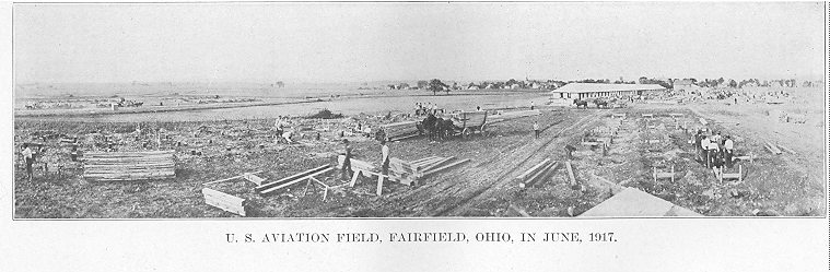
WRIGHT AVIATION FIELD.
The war department located one of its several aviation fields adjoining the village of Fairfield in
the summer of 1917 and this has resulted in more people visiting the town during the past year
than in all the previous years of its history. The field, known as the Wilbur Wright Aviation
Field, contains about twenty-five hundred acres and is one of the best equipped fields which the
war department has provided for the training of aviators. There are accommodations for several
thousand men, and in the summer of 1918 the field was filled to its fullest capacity. The first
soldiers arrived at the camp on June 2, 1917, and there have been some men there ever since,
al-though during the winter of 1917-18 most of them were taken to southern camps.
FAIRFIELD BUSINESS AND PROFESSIONAL DIRECTORY IN 1918.
Automobile dealer, William Evans; blacksmith, D. E. Knisley, Edwin Knisley; carpenters and
contractors, Snediker Brothers; cement workers, Sower Brothers; churches, Methodist Episcopal,
Reformed; garage, Adam Longstretch; general store, Frank Herr; grist mill, Orville Armstrong;
grocery, Wesley Koogler, William L. Douglass, R. . Routzong; hotel, C.
GREENE COUNTY, OHIO - 295
L. Hoagland; ice-cream parlor, William L. Douglass; justice of the peace, A. L. Shuey; mayor,.
O. A. Wilson; meat market, Wesley Koogler ; notary, A. L. Shuey, O. A. Wilson ; painters and
decorators, Wilson & Bressler; physician, H. A. Cosler; postmaster, W. L. Douglass; restaurant,
Hufford Hagenbuck, F. O. Wingart, Harry Kline; shoe cobbler, John Beaver ; saw-mill, Downey
Brothers.
CHAPTER XVI.
MIAMI TOWNSHIP.
Miami township was organized out of parts of Xenia and Bath townships pursuant to an order of
the commissioners, dated June 8, 1808. The original boundary of the township as defined by the
commissioners was as follows:
Ordered by the commissioners that a new Township be laid off in the county of Greene.
Beginning at the northeast corner of Section, No. 6, in Town 3, 8th Range ; then south to the
northeast corner of section of No. 5 in the 3rd Township 7th Range thence due East to the East
boundary of Greene county to be called and known by, the name of Miami township. And that
the first meeting of Electors in said township for the purpose of holding Township Election be in
the house of David S. Brodrick at the Yellow Springs on the last Saturday in June, inst.
Isaiah Grover was ordered to survey the south boundary of the new township from where it
crossed the Little Miami river to the eastern bound-ary of the county.
This description is very difficult to follow, and particularly because so much of the township was
in what is now Clark county. There was no Clark county until March 1, 1818, and consequently
all of the northern townships of Greene county included parts of what became Clark county in
that year. The northwest corner of the Miami township of 1808 adjoined Champaign county and
was in the present Mad River township of Clark county, two miles north of the. northeast corner
of Bath township as now constituted. From this corner of Miami township. its west line extended
south seven miles to the south line of Bath township; thence east to. the pres-ent east line of
Greene county; thence north to the Champaign county line ; thence west to the place of
beginning.
The township lost a considerable stretch of its territory when Ross was organized on March 4,
1811. When Clark county was set off on March 1, 1818, Miami township was reduced to
practically its present limits. It took a second act of the General Assembly to straighten out the
Greene-Clark line. It appears that Gen. Benjamin Whiteman, then a resident of Clifton, had been
thrown into the newly organized Clark county and he objected. He raised such an objection and
was possessed of so much influence that he had a bill introduced into the General Assembly for
the express purpose of legislating him back into Greene county. The act of January 25, 1819, so
changed the Greene-Clark line that Whiteman was left in Greene county.
GREENE COUNTY, OHIO - 297
A complete explanation of this northern boundary line is given in the chapter on County
Organization.
But this was not the end of the troubles that the county commissioners had in getting the limits of
Miami township fixed as they are today. The records show that no fewer than three times in after
years, efforts were made to rectify the line between Miami and Ross townships. These three
efforts were in 1828, 1832 and 1843. Let the commissioners' records tell the story :
Ordered by the Commissioners that Moses Collier, Esq., do proceed on or before the 14th inst. to
Survey and mark the line between Miami and Ross Townships. Beginning at the North East
corner of Xenia Township and running north until it strikes the Clark County line. June 5, 1828.
Ordered that the line between Miami & Ross Townships be changed and established in the
manner following: To start at the present corner of said Townships being an elm in the line of
Xenia Township, running northwesterly with the said Xenia Township line 145 poles so as to
include the new road leading to South Charleston ; thence a due North course until it strikes the
line of Clark County. March 7, 1832.
Samuel Kyle was appointed by the commissioners at their June session, 1843, to survey and
make a plot of a line of partition between Ross and Miami townships on a petition presented to
the commissioners to attach a part of Ross to Miami township. On August 184.3, Kyle made the
following report :
Pursuant to an order from the Honorable Board of Commissioners of Greene County, bearing
date of their term of June. 1843, requiring the survey and the plot of the line of partition between
Ross and Miami Townships. To begin at the new corner of Miami Township in Xenia Township,
North line Running Eastwardly with said line to the original corner of Miami in the Ross
[township) line ; thence South with [the] Xenia and Ross [township] line to the south line of
Wright's survey ; thence Eastwardly with the line of said survey and the North line of William
Thorn's [survey], North to the Clark County line ; thence with the county line West to the Miami
and Ross corner in said county line; thence with the line of said townships to the Beginning. The
undersigned proceeded to survey the same, Beginning at a stake, white oak, hickory and black
oak, southeast corner of Miami Township and running thence S. 89 [degrees] E. 145 poles
crossing Massies creek at 20 poles to a burr oak, elm and jack oak. [at] corner to Xenia
Township; thence S. [degree] W. 394 poles to the two hickories and elm in Xenia Township line;
thence with the southerly line of Wright's survey N. 56 [degrees] E. 802 poles to [Wright's and
William Thorn's corner] three Burr oaks ; thence N. 392 poles crossing Massies creek at 293
poles to a stake in the line of Clark County ; thence West 12 poles to a stake ; thence North 175
poles to a stake ; thence N. 86% [degrees] W. 794 poles to a stake new corner to Miami
Township; thence South 673 poles to the Beginning. Containing 3,939 acres or 6 15/100 square
miles. All of which is respectfully submitted. August 11th, 1843.
SAMUEL KYLE, S. G. C.
VIRGINIA MILITARY LANDS.
Miami township as originally constituted had considerable military land within its limits, but
since it has been reduced to its present size it has lost most of it. All that part of the township east
and south of the Little Miami
298 - GREENE COUNTY, OHIO
river falls within the Virginia Military Survey. This leaves about twenty-four sections of
Congress land in the township. There are only seven mili-tary surveys wholly or in part in the
township. The proprietors of these surveys, their number and acreage are set forth in the
following table :