HISTORY OF HANCOCK COUNTY - 25
those interested to meet in February in their respective counties and choose delegates to a convention to be held at the "Bunch of Grapes" Tavern in Boston on March I, 1786. The purpose was to be the formation of a company and the adoption of definite plans for establishing a settlement in the Ohio Valley. On the day appointed eleven persons appeared, an outline was drawn up, and subscriptions began at once. The principal features of the plan were as follows : "A fund of $1,000,000, mainly in continental certificates, was to be raised for the purpose of purchasing lands in the western country; there were to be I,000 shares of $1,000 each, and upon each share $1 o in specie were to be paid for contingent expenses. One year's interest was to be appropriated for the charges of making a settlement and assisting those unable to move without aid. The owners of every twenty shares were to choose an agent to represent them and attend to their interests, and the agents were to choose the directors. The plan was approved, and in a years' time from that date the company was organized."
On the 8th of March, 1787, a meeting of the agents chose General Parsons, General Rufus Putnam and Rev. Manassah Cutler, directors for the Company. The selection of Manassah Cutler was extremely fortunate for the success of the enterprise, as few men could have been better fitted, both in character and ability, to conceive and execute a project of such importance as this would prove to be. A contract was made with the Treasury Board by Cutler and Winthrop Sargent, as agents for the Board of Directors of the Ohio Company, on October 27, 1787, by which there was conveyed to the company a vast region bounded on the south by the Ohio River, west by the Scioto, east by the seventh range of townships then surveying, and north by a due west line drawn from the north boundary of the tenth township from the Ohio direct to the Scioto, for the consideration of $1 per acre. Later, in 1792, the boundaries of the purchase were fixed as follows : The Ohio on the south, the seventh range of townships on the east, the sixteenth range on the west, and a line on the north so drawn as to make the grant 750,000 acres, besides reservations, this grant being the portion which it was originally agreed the company might enter into at once. In addition 214,285 acres were granted as army bounties, and ioo,000 acres as bounties to actual settlers. While these preliminary arrangements for the occupation of the new territory were being carried out, Congress was likewise providing a plan for its government. The famous instrument known as the Ordinance of 1787, under which the first organization of the territory was effected, was passed on July 13th of that year, but of it we shall speak more in detail later on.
In the winter of 1787 General Rufus Putnam and forty-seven pioneers proceeded as far as the mouth of the Youghiogheny River, and, having built a boat for transportation down the Ohio, proceeded in the spring to the mouth of the Muskingum, where they landed on the 7th of April, 1788. Fort Harmar had previously been built at the mouth of the Muskingum, and it was on the opposite side of this river that the pioneers established their settlement which they later called Marietta, in honor of Marie Antoinette. With regard to this settlement of Ohio, George Washington wrote : "No colony in America was ever settled under such favorable auspices as that which has commenced at the Muskingum. Information, property, and strength will be its characteristics. I know
26 - HISTORY OF HANCOCK COUNTY
many of the settlers personally and there never were men better calculated to promote the welfare of such a community."
Soon after their arrival the settlers began the erection of a stockade fort, which occupied their time until the winter of 1791. During the early years of the settlement, however, the Indians were friendly, no hostilities being experienced. One of the pioneers describes the progress of the colony during its first year as being all that could be expected, arrivals coming faster than provision could be made for them. By the close of the year 1790 eight settlements had been made within the Ohio Company's purchase, two at Belpre, one at Newbury, one at Wolf creek, one at Duck Creek, one at the mouth of Meigs' Creek, one at Anderson's Bottom, and one at Big Bottom.
Not long after the grant of lands was made to the Ohio Company, John Cleves Symmes, of New Jersey, contracted with the Treasury Board for the purchase of a large tract of land lying between the Great and Little Miami Rivers. The terms of this purchase were similar to those of the Ohio Company. In July, 1788, he got together thirty people and eight four-horse wagons who started for the West. After meeting with Mr. Stites and a company from Redstone, Pa., they proceeded, under his leadership, to the mouth of the Little Miami, where they arrived before the 1st of January, 1789, and located on a tract of 10,000 acres which Stites had purchased from Symmes. This settlement, which they named Columbia and which was located about five miles above the site of Cincinanti, was the second settlement within Ohio territory.
In 1788 Mathias Denman purchased of Symmes a tract of land opposite the Licking River, and, in company with Robert Patterson and John Filson, to each of whom he sold a third interest in his purchase, projected the location of a town on the present site of Cincinnati. There is some uncertainty as to the exact time when a settlement was first made here, but it seems to have been late in 1788 or early in 1789. Symmes himself had contemplated building his main town at North Bend, near the mouth of the Great Miami. The fact, however, that this point, as well as Columbia, suffered severely during a great flood which occurred in 1789, while Losantiville, as Cincinnati was then called, escaped, had much to do with the fact that the latter soon outstripped the others in its growth. Ensign Luce, who had been commissioned by General Harmar to establish a fort, decided that North Bend was not a suitable location for that purpose, and, contrary to the wishes of Symmes, selected Losantiville. Fort Washington was thus established here. About the 1st of January; Governor St. Clair organized the county of Hamilton and constituted Cincinnati its seat of justice. The settlement at once began an active growth, outstripping that of all the others in the Ohio Valley.
At the time Dr. Cutler secured the grant of lands for the Ohio Company, he likewise secured a large additional tract, as he himself writes, "for private speculation, in which many of the prominent characters in America are concerned ; without connecting this speculation, similar terms and advantages could not have been obtained for the Ohio Company." A company was at once formed known by the name of The Scioto Land Company, which contracted with Cutler and Sargent on behalf of the Ohio Company for a tract of land west and north of the Ohio Company's purchase.
HISTORY OF HANCOCK COUNTY - 27
Joel Barlow was sent to Europe, as the agent of the company, to make sales of the lands thus contracted for. He sold parts of the land to companies and individuals in France. It developed, however, that the lands which Barlow had presumed to sell were included within the Ohio Company's purchase, and that the purchasers were without title. In ignorance of this fact, however, two hundred and eighteen of these purchasers sailed from Havre de Grace, in France, on the 19th day of February, 1791, and arrived in Alexandria, D. C., on the 3rd of May following. On their arrival they proceeded to Marietta, where fifty of them landed, the remainder going to the present site of Gallipolis, which the agent of the company assured them was within their purchase. Prior to their arrival General Putnam had had the site cleared and buildings erected for their reception. As before stated, however, the lands to which alone they could lay any claim, were still farther to the West. Moreover, the Scioto Land Company, by having failed to make good the payments on its contract, forfeited its title to the land which it had purchased, thus leaving the settlers themselves without any vestige of title. These settlers, unlike the hardy pioneers who came from New England, were little accustomed to toil or to the privations of frontier life. Their condition was pitiable in the extreme and many gave up in despair, some seeking homes in the East and a few returning to France. Every effort to secure titles to the lands on which they had settled having failed, they petitioned Congress for assistance and in June, 1787, a grant was made them of land on the Ohio above the mouth of the Scioto River. The tract included 24,000 acres and is known as the French Grant.
During the progress of the various campaigns against the Indians, conducted successively by General Harmar, General St. Clair, and General Wayne, the settlement of Ohio was interrupted to a large extent. Prior to the treaty made with the Indians by General Wayne in 1795, however, a start had been made in several counties, in addition to those in Washington and Hamilton counties already mentioned. The settlement at Gallipolis has already been described. There were also small settlements in Adams, Belmont and Morgan Counties. They were block-house settlements and were in a continual state of defense. The first was settled in the winter of 1790-91 by General Nathaniel Massie, near where the town of Manchester now is. This was the first settlement within the bounds of the Virginia Military District and the fourth in the State. In spite of the dangers due to the hostility of the Indians, it continued to grow and, in two years after peace was declared, Adams County was constituted by order of Governor St. Clair.
During the Indian war a settlement was commenced near the present town of Bridgeport in Belmont County, by Captain Joseph Belmont, a noted officer of the Revolutionary War. Shortly afterwards a fort, called Dillie's Fort, was built on the Ohio, opposite the mouth of Grave Creek. In 1794 a company of men located on the present site of Hamilton in Butler County. The town was first laid out under the name of Fairfield. These were about all the settlements begun prior to the close of the Indian War and they were, for the most part, of a temporary character and maintained only at constant risk and great loss of life. With the termination of the war, however, and the cessation of Indian hostility emigration took a new impetus, and from that
28 - HISTORY OF HANCOCK COUNTY
time the growth of the State's population was constant and vigorous.
Early in the spring of 1796 the first settlement was.begun in Montgomery County. The town of Dayton was laid out in November of 1795. It was within the tract originally covered by Symmes' purchase. Judge Symmes, having been unable to pay for his purchase, the land reverted to the government and the settlers found themselves without title. Congress, however, came to their aid, permitting them to enter their lands at the regular government price.
It was likewise in 1796 that the first settlements were made in the Western Reserve. The mouth of the Cuyahoga River had always been considered an important place in the West and destined to become a great commercial mart. A corps of surveyors laid out the town of Cleveland in September, 1796. It was named in honor of General Moses Cleave-land, the agent of the land company which had made large purchases in the Western Reserve along the Cuyahoga River. Mahoning County was settled about the same time, as were also the counties of Ashtabula, Rose, Licking, Madison, Trumbull, and Warren. In a sketch of such a limited character as this we cannot pursue the history of the individual settlements further. It was not long until the settlers had penetrated to every portion of the State, clearing the land, starting industries of various kinds, and preparing the way for the marvelous prosperity which has ever since characterized the history of the Commonwealth.
INDIAN WARS.
Ohio has had its full share of conflict with the various tribes of Indians which were the original possessors of its soil. Being the first State in the vast region northwest of the Ohio River within whose limits settlement by the English was begun; it naturally became the scene of the early struggles through which the savage tribes were subdued and the land made possible of habitation for the white man. While we have given, in tracing the derivation of the title to the lands, the various Indian treaties which formed a link in that title, we have reserved for statement, here, a brief account of the wars which led up to the making of these treaties, or their enforcement. With regard to the wars which took place prior to the organization of the government of the territory, we quote the concise account given in Howe's History :
"After Braddock's defeat in 1755 the Indians pushed their excursions as far east as the Blue Ridge. In order to repel them, Major Lewis, in January, 1756, was sent with a party of troops on an expedition against the Indian towns on the Ohio. The point apparently aimed at was the upper Shawanese town, situated on the Ohio, three miles above the mouth of the great Kanawha. The attempt proved a failure, in consequence, it is said, of the swollen state of the streams and the treachery of the guides. In 1764, General Bradstreet, having dispersed the Indian forces besieging Detroit, passed into the Wyandot country by way of Sandusky Bay. He ascended the bay and river as far as it was navigable for boats, and there made a camp. A treaty of peace was signed by the chiefs and head men. The Shawnees of the Scioto River and the Delawares of the Muskingum, however, still continued hostile. Colonel Bouquet, in 1764, with a body of troops, marched from Fort Pitt into the heart of the Ohio country on the Muskingum River. This expedition was conducted with
HISTORY OF HANCOCK COUNTY - 31
great prudence and skill and with scarcely any loss of life. A treaty of peace was effected
with the Indians, who restored the prisoners they had captured from the white settlements.
The next war with the Indians was in 1774, generally known as Lord Dunmore's. In the
summer of that year an expedition under Colonel McDonald was assembled at Wheeling, marched into the Muskingum country, and destroyed the Indian town of Wapatomica, a few miles above the site of Zanesville. In the fall the Indians were defeated after a hard fought battle at Point Pleasant, on the Virginia side of the Ohio. Shortly after this event Lord Dunmore made peace with the Indians at Camp Charlotte, in what is now Pickaway County.
"During the Revolutionary War most of the western Indians were more or less united against the Americans. In the fall of 1778 an expedition against Detroit was projected. As a preliminary step it was resolved that the forces in the West, under General McIntosh, should move up and attack the Sandusky Indians. Preliminary to this, Fort Laurens, so called in honor of the President of Congress, was built upon the Tuscarawas, a short distance below the site of Bolivar, Tuscarawas County. The expedition to Detroit was abandoned, and the garrison of Fort Laurens, after suffering much from the Indians and from famine, was recalled in August, 1779. A month or two previous to the evacuation of this fort Colonel Bowman headed an expedition against the Shawnees. Their village, Chillicothe, three miles north of the site of Xenia, on. the Little Miami, was burned. The warriors 'showed an undaunted front and the whites were forced to retreat. In the summer of 1780 an expedition directed against the Indian towns in the forks of the Muskingum, moved from Wheeling under General Broadhead. This expedition, known as the 'Coshochton campaign,' was unimportant in its results. In the same summer General Clark led a body of Kentuckians against the Shawnees. Chillicothe, on the Little Miami, was burnt on their approach, but at Piqua, their town on the Mad River, six miles below the site of Springfield, they gave battle to the whites and were defeated. In September, 1782, this officer led a second expedition against the Shawnees. Their towns, Upper and Lower Piqua, on the Miami, within what is now Miami County, were destroyed, together with the store of a. trader.
"There were other expeditions into the Indian country, which although of a later date, we mention in this connection. In 1786 Colonel Logan conducted a successful expedition against the Mackachack towns, on the head waters of Mad River, in what is now Logan County. Edwards, in 1787, led an expedition to the head waters of the Big Miami, and, in 1788, Todd led one into the Scioto Valley. There were also minor expeditions at various times into the present limits of Ohio.
"The Moravian missionaries, prior to the war of the Revolution, had a number of missionary stations within the limits of Ohio. The missionaries, Heckewelder and Post, were on the Muskingum as early as 1762. In March, 1782, a party of Americans, under Colonel Williamson, murdered, in cold blood, ninety-four of the defenceless Moravian Indians, within the present limits of Tuscarawas County. In the June following, Colonel Crawford, at the head of about 500 men, was defeated by the Indians three miles north of the site of Upper Sandusky, in Wyandot County.
32 - HISTORY OF HANCOCK COUNTY
He was taken prisoner and burnt at the stake with horrible tortures."
Although by the various treaties which we have heretofore mentioned, the English had secured title to the lands northwest of the Ohio, the Indians did not take kindly to the coming of the white settlers, and it was not long after their arrival that they began to show themselves hostile. That they were instigated, in some measure, by the British, cannot be doubted. Much could be traced to the malicious influence of the British superintendent of Indian affairs, Colonel McKee, his assistant, Captain Elliott, and the notorious white renegade, Simon Girty. A treaty confirming the former one made at Fort McIntosh, was made with the Indians at Fort Harmar in the year 1789. It had little effect, however, in staying Indian hostilities. In 1790 a company of 36 men went from Marietta to a place on the Muskingum known as Big Bottom. In view of the apparent unfriendliness of the Indians, the postponement of the settlement was advised by General Putnam and others. Moreover proper precautions were not taken against possible attacks. In an unguarded moment these settlers were set upon by the Indians and twelve of them killed. The settlers throughout the new territory immediately became alarmed and block-houses were erected for their protection. In 1789 Fort Washington was built within the present limits of Cincinnati, and a few months later General Harmar arrived with 30o men and assumed command. It was determined by Governor St. Clair and General Harmar to send an expedition against the Maumee towns and secure that part of the country. While St. Clair was forming his army and arranging for this campaign three expeditions were sent out against the Miami towns. One against the Miami villages, not far from Wabash, was led by General Harmar. With about fourteen hundred men, of whom less than one-fourth were regulars, he marched from Cincinnati in September, 1790. When near the Indian villages an advanced detachment fell into ambush and was defeated with severe loss. General Harmar, however, succeeded in burning the Indian villages and destroying their standing corn, after which he commenced the return to Cincinnati. Having received intelligence, however, that the Indians were returning to their ruined towns, he detached about a third of his remaining force, with orders to bring the Indians to an engagement. In the engagement which followed, more than one hundred of the militia were killed and all but nine of the regulars, the remainder being driven back to the main force. The expedition served little purpose other than to make the Indians, if anything, bolder than before. An army under Charles Scott was sent against the Wabash Indians. Nothing was accomplished save the destruction of towns and standing corn. In July another army under Colonel Wilkinson, was sent against the Eel River Indians. It became entangled in extensive morasses on the river and accomplished no more than the other expeditions which had preceded it..
ST. CLAIR'S DEFEAT.
Encouraged by the meager success of the whites in these expeditions, the chiefs of the Miamis, Shawnees and the Delawares now began the formation of a confederacy among all the tribes of the northwest territory, which, they conceived, would be strong enough to expel the whites beyond the Ohio. While they were making ready, however, Governor
HISTORY OF HANCOCK COUNTY - 33
St. Clair was engaged in the organization of a new army. He gathered together a force consisting of 2,300 regulars and boo militia. It was his purpose to establish a chain of forts from the Ohio, by way of the Miami and Maumee Valleys, to the lakes. The plan was favored by Washington and General Knox, then secretary of war. It was said that a spirit of idleness, drunkenness and insubordination characterized the army at this time and had much to do with the defeat which followed later. On September 17, the army began its march and moved to a point on the Great Miami, where Fort Hamilton was established, the first in the chain mentioned above. The army then proceeded forty-four miles further on and erected Fort Jefferson, about six miles south of the present town of Greenville, in Darke County. On the 24th of October it again began its march through the wilderness, marshy and boggy and infested with savage foes. By the 3rd of November a stream was reached which St. Clair supposed to be a branch of the St. Mary of the Maumee, but which in reality was a tributary of the Wabash. The point was on what is now the line between Darke and Mercer Counties. The army had been so far depleted by desertion at this time that only about 1,400 men were left. St. Clair sent the first regiment, under Major Hamtramck, to pursue the deserters and secure the advancing convoys of provisions which it was feared the deserters intended to plunder. When they halted on the banks of the stream before mentioned, it encamped in two lines and threw up some slight fortifications against the Indians who were known to be in the neighborhood. On the next morning, about half an hour before sunrise, it Was attacked furiously by the Indians. The evil effects of the insubordination before mentioned and the lack of sufficient drill were now made manifest. The army was thrown into hopeless confusion. It is probable that the whole disposable force of the tribes in the Northwest participated in the attack on St. Clair's army at this time. After losing about Boo men it began its retreat, which was a disgraceful, precipitate flight. After reaching Fort Jefferson it proceeded, by way of Fort Hamilton, back to Fort Washington.
This defeat was one of the worst ever suffered by an American army at the hands of the savage tribes, outrivaling even Braddock's defeat in this regard. It left the entire frontier exposed to the onslaughts of the savages, who were determined now, more than ever before, to exterminate the whites entirely. Execrations were heaped upon St. Clair who led the army to its terrible defeat. Under a more forceful commander, perhaps the result might have been different, yet the defeat was due, not alone to the inefficiency of St. Clair, but to the general demoralization of the soldiers whose insubordination we have before mentioned.
Plans were immediately formed for another campaign against the Indians. General Wayne, whose bravery and ability, as well as his experience during the Revolution, rendered him peculiarly well fitted for the task, was called to take command of the army which was raised. He immediately began the work of drill and organization.
Meanwhile efforts were being made by the United States to conciliate the Indians and avoid the necessity of warfare. The Iroquois were induced to visit Philadelphia, and were partially secured from the confederacy which we have before mentioned. Five independent embassies were sent among the western tribes
34 - HISTORY OF HANCOCK COUNTY
in an effort to win them over and prevent war. All the embassadors were slain, however, except Putnam, who succeeded in reaching the Wabash Indians and effecting a treaty which was later rejected by Congress on account of its terms. A great council of the Indians, in which were represented all the tribes of the Northwest, and many others, assembled at Auglaize during the autumn of 1792, and prepared an address to the President wherein they agreed to abstain from hostilities until they could meet with the whites at the rapids of the Maumee in the following spring for a conference. The President appointed commissioners who, in accordance with the arrangement, met the representatives of the tribes at the appointed place. The Indians, however, would consent to nothing save the Ohio River as the boundary of their lands. This being out of the question for the whites, the negotiations came to an end.
WAYNE'S CAMPAIGN AND BATTLE OF
FALLEN TIMBER.
Nothing was now left save war. General Wayne, on being informed of the termination of the efforts at securing a treaty, immediately began active preparations for a campaign against the Indians. Pending the negotiations with the Indians he had been sending out scouts and spies on errands of discovery and he had his plans by this time practically matured. All his information showed plainly that the Indians were receiving constant aid and encouragement from the British. He had spent the winter of 1793-94 at a fort which he had built on a tributary of the Great Miami, and which he called Greenville. The present town of Greenville is near the site of the fort. On the 26th of July, 1794, General Scott, with 1,600 m0unted men from Kentucky, joined General Wayne at Greenville, and two days later the entire army moved forward, reaching the junction of the Auglaize and Maumee on the 8th of August, where they erected Fort Defiance. As Wayne's army moved n0rthward the Indians aband0ned their t0wns and collected their entire force, amounting to about two thousand men, near a British fort, erected in violation of the treaty of 1783, at the rapids of the Maumee. Before attacking the Indians, however, Wayne made still another attempt to conciliate them. He sent Christopher Miller, who had been naturalized among the Shawnees, and taken prisoner by Wayne's spies, as a messenger of peace. Miller returned with the message that if the Americans would delay for ten days the Indians w0uld, within that time, decide the question of war or peace. Knowing the Indian character, however, Wayne determined to move forward. On the 18th of August, having marched forty-one miles from Auglaize, and being now near to the enemy, a fortification was erected which they called Fort Deposit. They remained here until the l0th, when they again took up their march. After having proceeded about five miles the foe was encountered. In striking contrast with the condition of St. Clair's army at the time it had suffered its crushing defeat, the army was now well disciplined and fully able to cope with the enemy. The conflict which ensued was one of the fiercest in the history of Indian warfare. The Indians were completely routed and many of them were slain, while the American loss was com-
HISTORY OF HANCOCK COUNTY - 35
paratively slight. This celebrated engagement is what is familiarly known as the battle of Fallen Timber. It was fought almost under the walls of the British fort. When the commander of that fort demanded an explanation of Wayne as to why he had fought so near and in evident hostility to the British, Wayne replied, not only by telling him he had no rights in the country, but by also marching forward and devastating the Indian country.
While the Indians were not immediately subdued by the crushing defeat received from Wayne, yet it went a long way towards breaking the strength of their hostility. Recognizing, at length, that opposition to the encroachments of the whites was useless, and that their ultimate subjugation was only a matter of time, they were willing to sue for peace. They arranged to meet General Wayne in June, 1795, at Greenville and form a treaty. This plan was carried out and the Greenville treaty, which marked the close of the Indian wars in the West, was the result.
ORGANIZATION OF THE NORTHWEST TERRITORY.
After the title to the lands northwest of the Ohio had become vested in the United States, and active preparations for their settlement began to be made, it became necessary for Congress to provide some form of government for the territory. The matter was one calling for the exercise of the highest statesmanship, and various plans were under discussion before a final settlement was reached. At one time Congress, under the influence of the Southern States, voted down Jefferson's proposition excluding slavery forever from the terri tory. It was likewise proposed to divide the territory into ten states to be known as Sylvania, Michigania, Cheresonisius, Assenispia, Metropotamia, Illinoia, Saratoga, Washington, Polypotamia and Pelisipia, the ultimate arrangement being, however, that there should be no less than three nor more than five states. The instrument which was finally adopted for the government of the Northwest Territory, and ever since popularly known as the "Ordinance of 1787," was, in large measure, the result of the efforts of Rev. Manassah Cutler, before mentioned as being instrumental in securing the grant of lands to the Ohio Company. It was passed on the 13th of July, 1787. Its cardinal principles were : 1st. —The exclusion of slavery from the territory forever; 2nd.—Provision for public schools, giving one township for a seminary and every sixteenth section (this gave one thirty-sixth of all the land for public education) ; 3rd. —Freedom in religious worship and opinion; 4th.—The equal distribution of estates; and 5th.—Protection in civil liberty. It also provided for the appointment of a governor who should likewise be commander of the militia, a secretary, and for three judges. The governor and the judges were to have the power to adopt and publish such of the laws of other states as should be suitable to their circumstances. Whenever there should be 5,000 free male inhabitants, of full age, in the district, they were to have authority to elect representatives to a General Assembly, which was to consist of the Governor, a Legislative Council and a House of Representatives. There was the further pro-
36 - HISTORY OF HANCOCK COUNTY
vision that not less than three nor more than five states were to be formed out of the territory, the states to be admitted to equal standing with the original states of the Union whenever they had a population of 60,000, or sooner if consistent with the general interest. The principles embodied in the ordinance were in the form of a compact irrevocable save by consent of both Congress and the states that should be formed out of the territory. It was by reason of this fact that the South was afterwards powerless when they endeavored to have the territory opened to the admission of slavery.
In October, 1787, Congress appointed Gen. Arthur St. Clair, who had been an officer in the Revolution, governor of the new territory, Winthrop Sargeant, secretary, and Samuel H. Parsons, John Armstrong, and James M. Varnum, judges. Subsequently Armstrong declined the appointment and John Cleves Symmes was given his place. Governor St. Clair arrived at the Marietta settlement on July 9, 1788, and immediately began his duties. On the 25th, the first law, relating to the militia, was published, and the next day the governor issued a proclamation creating all the country that had been ceded by the Indians, east of the Scioto River, into the county of Washington. After organizing the militia he next erected the Courts of Probate and Quarter Sessions, and proceeded to appoint civil officers. Rufus Putnam, Benjamin Tupper and Winthrop Sargeant, were made justices of the peace. The 30th day of August, the day the Court of Quarter Sessions was appointed, Archibald Cary, Isaac Pierce and Thomas Lord were also appointed justices. Return Jonathan Meigs was appointed clerk of this Court of Quarter Sessions. Ebenezer Sprout was appointed sheriff of Washington County and also colonel of the militia; William Callis, clerk of the Supreme Court ; Rufus Putnam, judge of the Probate Court, and Return J. Meigs, Jr., clerk.
On September 2nd, the first court was held. It is thus described by the American Pioneer: "The procession was formed at the Point (where most of the settlers resided), in the following order : The high sheriff, with his drawn sword; the citizens; the officers of the garrison at Fort Harmar ; the members of the bar; the supreme judges ; the governor and clergymen; the newly appointed judges of the Court of Common Pleas, Generals Rufus Putnam and Benjamin Tupper.
"They marched up the path that had been cleared through the forest to Campus Martius Hall (stockade), where the whole counter-marched, and the judges, Putnam and Tupper, took their seats. The clergyman, Rev. Dr. Cutler, then invoked the divine blessing. The sheriff, Ebenezer Sproat, proclaimed with his solemn 'Oh yes' that a court is open for the administration of even-handed justice to the poor and to the rich, to the guilty and to the innocent, without respect of persons ; none to be punished without a trial of their peers, and then in pursuance of the laws and the evidence in the case.
"Although the scene was exhibited thus early in the settlement of the West, few ever equaled it in the dignity and exalted character of its principal participators. Many of them belonged to the history of
HISTORY OF HANCOCK COUNTY - 37
our country in the darkest as well as the most splendid period of the Revolutionary war."
About the 1st of January, 1790, Governor St. Clair, with his officers, went to Fort Washington, on the present site of Cincinnati, and established the county of Hamilton, in which was comprised all the country contiguous to the Ohio, from the Hocking River to the Great Miami. He also appointed a corps of civil and military officers and erected a Court of Quarter Sessions. A short time later he likewise organized the county of St. Clair, whose limits, however, were comprised within the present State of Indiana, and Illinois, including the country from the Wabash to the Mississippi. Before the close of 1795 the governor and the judges published sixty-four statutes. Among other things they provided that the common law of England, and all its statutes made previous to the fourth year of James I., should be of full force in the territory. Wayne County was organized in 1796, Jefferson and Adams in 1797, and Ross in 1798.
Wayne County, established by proclamation August 13, 1796, embraced a large extent of territory. It began at the mouth of the Cuyahoga River, and extended south along the western border of Washington County to Fort Lawrence; thence west to the eastern border of Hamilton County; thence north-north-west to the site of Fort Wayne; then west north to the southern shore of Lake Michigan ; then along the shore to the north part thereof, including the lands along the streams falling into the lake; then north to the territorial boundary of Lake Superior, and with said boundary through Lakes Huron, St. Clair and Erie to the place of beginning. This vast region, then known as Wayne County, included most of the State of Ohio, the eastern part of the State of Indiana and the whole of Michigan, and it remained as such until the admission of Ohio into the Union as a State in 1893. Then that portion of the so-called Wayne County included in the limits of the State of Ohio, was divided into various counties under the state government. The north portion of Ohio remained unorganized until February 12, 1820. Explorers and hunters had reported that the country was worthless from the fact that it would cost more to remove the heavy timber from the land than the latter would be worth after its removal, and that even after the timber had been taken off the ground was to0 flat and wet for agriculture.
As has before been stated, the Ordinance of 1787 provided that whenever there should be 5,000 persons in the territory they should be entitled to a representative assembly. On October 29, 1798, Governor St. Clair proclaimed that the population had reached the required number, and ordered an election for the third Monday in December. The representatives thus elected met in Cincinnati, January 22, 1799, and, under the provisions of the Ordinance, nominated ten persons, from whom the President should select five to constitute the Legislative Council. The persons chosen were : Jacob Burnet, James Finley, Henry Vander-burgh, Robert Oliver and David Vance. The Territorial Legislature again met at Cincinnati on the 24th of September, when a great amount of business was done. They repealed some of the laws that were already in force, adopted others, created and filled new offices and devised various plans and methods for carrying on the government of the new territory. The only lawyer in the body was Mr. Burnet, upon whom, by reason of his profession, a
38 - HISTORY OF HANCOCK COUNTY
great amount of the work devolved. He seems to have acquitted himself well in the position in which he was thus placed. The whole number of acts passed and approved by the governor was thirty-seven. It is worthy of note that a bill authorizing a lottery was passed by the Council but rejected by the Legislature.
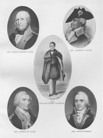
Among other duties which devolved on this session of the Legislature was the election of a delegate to Congress. The choice fell upon William Henry Harrison, the secretary of the territory at that time. He at once resigned his office and proceeded to Philadelphia to take his seat in Congress which was then in session. He was successful in obtaining many important advantages for his constituents, among others a measure subdividing the surveys of the public lands and permitting them to be sold in smaller tracts, thus making it possible for them to be purchased by individuals without first coming into the hands of speculators.
At this first session of the Legislature Governor St. Clair saw fit to veto eleven acts which were passed by it. The greater part of them related to formation of new counties, a right which the governor claimed was vested in him alone. The attitude of the governor served to increase his unpopularity with the people, whose confidence he seems to have lost, in large measure, after his disastrous defeat at the hands of the Indians.
In the year 1800 Congress took up the matter of dividing the Northwest Territory into two parts. The great extent of the territory rendered extremely difficult and unsatisfactory the operations of the government. By reason of the loose administration of justice in its western part, that portion had become a rendezvous for criminals of various character, with the consequent effect of deterring better citizens from settling there. The judiciary was likewise wholly inefficient as regarded civil cases. The far western frontier, being at such a great distance from the seat of both the national and territorial governments, could neither feel for them the attachment or fear their restraint to the extent that a closer relation would establish. In consequence, on the 7th of May an act was passed dividing the territory, the line of division being "a line beginning at the Ohio, opposite to the mouth of the Kentucky River, and running thence to Fort Recovery, and thence north until it intersects the territorial line between the United States and Canada." The same form of government was provided for the new territory as prevailed in the old. Chillicothe was made the seat of government for the old territory and St. Clair retained as governor, while St. Vincent's on the Wabash River, was made the capital of the "Indiana Territory," and William Henry Harrison appointed its governor.
ORGANIZATION OF THE STATE OF OHIO.
The second session of the General Assembly was held at Chillicothe in 1801. Governor St. Clair had, meanwhile, been growing more and more unpopular. The abuse heaped on the governor and the Legislature at Chillicothe became so great that they decided to remove the capital from that place to Cincinnati. Out of this agitation, however, and the general discontent with the governor, there had been rapidly arising a general sentiment in favor of the formation of a State government. This sentiment was in a minority, however, so far as the General Assembly was concerned. A measure was introduced there proposing that the Ordinance of 1787 be so changed that the Scioto River, together with a line drawn from its intersec-
HISTORY OF HANCOCK COUNTY - 39
tion with the Indian boundary to the western extremity of the Reserve, should be the western limit of the most eastern State to be formed out of the territory. To protest against this proposition the minority sent Thomas Worthington to Washington. While he was on his way a resolution introduced into the Legislature for choosing a committee to address Congress with regard to the proposed state was defeated. A further attempt providing for taking the census of the territory was postponed by the Council.
Worthington, however, was successful in his mission to Congress, and on the 30th of April that body authorized the calling of a state convention for the purpose of forming a constitution, provided it was found expedient. "The act of Congress, providing for the admission of the new state into the Union, offered certain propositions to the people. These were, first, that Section Sixteen in each township, or, where that section had been disposed of, other contiguous and equivalent lands, should be granted to the inhabitants for the use of schools; second, that thirty-eight sections of land, where salt springs had been found, of which one township was situated on the Scioto, one section on the Muskingum, and one section in the United States Military Tract, should be granted to the state, never to be sold or leased, however, for a longer term than ten years ; and third, that one twentieth of the proceeds of the public lands sold within the state, should be applied to the construction of roads from the Atlantic, to and through the same." These propositions were offered on the condition that the convention should provide, by ordinance, that all lands sold by the United States after the 3oth day of June, 1802, should be exempt from taxation by the state for five years after sale.
The convention met at Chillicothe on the 1st day of November, 1802. While it believed the consideration offered to the state hardly sufficient for the tax exemption required, it decided to accept the conditions of Congress, providing their propositions should be sufficiently enlarged "so as to vest in the state, for the use of schools, Section Sixteen in each township sold by the United States, and three other tracts of land, equal in quantity, respectively, to one thirty-sixth of the Virginia Reservation, of the United States Military Tract, and of the Connecticut Reserve, and to give three per centum of the proceeds of the public lands sold within the state, to be applied under the direction of the Legislature, to roads in Ohio." Congress acceded to this modification and there was thus nothing to prevent the formation of the new state.
The time for the meeting of the General Assembly came while the constitutional convention was in session, but, owing to the probability that the territorial government would so soon be superseded by that of the state, they deferred meeting. On the 29th of November the convention having framed a constitution and completed its labors, adjourned. The constitution, though never submitted to the people, was submitted to Congress and accepted by that body, and an act passed admitting Ohio to the Union, February 19, 1803. The constitution framed by this convention continued in force until the adoption, in 1851, of the present one. The territorial government ended and the state government began on March 1, 1803.
By the new constitution it was provided that the first elections under the new government should be held the second Tuesday of January, 1803. Accordingly at that time Edward Tiffin was chosen governor and Jeremiah Morrow
40 - HISTORY OF HANCOCK COUNTY
sent to Congress. A General Assembly was also elected, which met on March 3rd and chose the following officers : Michael Baldwin, speaker of the House, and Nathaniel Massie of the Senate; William Creighton, Jr., secretary of state; Colonel Thomas Gibson, auditor; William McFarland, treasurer; Return J. Meigs, Jr., Samuel Huntington and William Spriggs, judges of the Supreme Court; Francis Dunlevy, Wyllys Silliman and Calvin Pease, president judges of the First, Second and Third Districts, and Thomas Worthington and John Smith, United States Senators. The Assembly also passed such laws as were necessary. Up to the time of the adoption of the state constitution there had been organized the following counties : Washington, July 27, 1788 ; Hamilton, January 2, 1790; Adams, July 10, 1797 ; Jefferson, July 29, 1797 ; Ross, August
20, 1798; Clermont, Fairfield and Trumbull, December 9, 1800; Belmont, September 7, 1801. Eight additional counties were created by the Assembly at its first session, viz. : Gallia, Scioto, Butler, Warren, Greene, Montgomery, Franklin and Columbiana.
The seat of government was first located at Chillicothe. In the year 1810 an act was passed changing its location to Zanesville, but at the next session of the General Assembly it was again taken back to Chillicothe, and commissioners appointed to determine upon a definite location. It is said that they first reported in favor of Dublin, a small town on the Scioto about fourteen miles above Columbus. At the session of the Assembly of 1813-14, however, the proposal of parties owning the site of Columbus was accepted and in 1816, the first meeting of the Assembly was held there.
CHAPTER II.
THE ABORIGINES.
Prehistoric Races—Pre-Glacial Man—The Mound Builders—The Red Race.
Hancock County may have been the home of man before the glacial period. There seems to be evidence, at least, that Ohio was occupied by human beings prior to this great geological epoch. Paleoliths have been found in the Little Miami Valley similar and under similar conditions to those unearthed by Dr. Abbott in the glacial terraces of the Delaware River. As to whether pre-glacial man ever had a home in Hancock County, however, in our present state of knowledge, could be nothing more than a matter of profitless speculation.
That the Mound-Builder lived here there is abundant evidence. The State of Ohio itself, from the standpoint of pre-historic occupation, is one of the most interesting portions of the entire globe. In no other equal area have s0 many of the Mound-Builder's works, consisting of fortifications, effigies, mounds, etc., been found. On this point we quote from the recent work of Gerard Fowke on the "Archeological History of Ohio." "The total number of mounds in Ohio has been estimated at ten thousand. This is probably under rather than over the correct figure ; for while they are almost unknown in the northwestern counties and are comparatively scarce in some parts of the rugged hill lands 0f the s0uth and southeast and along the main watersheds, there is scarcely a township in any other part where they are not found. In the neighborhood of every stream in the southern half of the State, except some of those follwing through rough or swampy country, the surface is so dotted with them that signals could be transmitted from one to another for a hundred miles or more. There is scarcely a point along the Scioto below Circleville, or on either Miami in the lower half of its course, or in the valley of any tributary to these streams, where one may not be within a few minutes ride of some permanent evidence of aboriginal habitation. The same is true of the Cuyahoga and some other rivers belonging to the Lake Erie basin. On the summits of steep hills ; in bottom lands subject to overflow, on every terrace bordering a stream ; on plateaus and uplands ; wherever there is cultivable or naturally drained land, a good point of observation, an ample supply 0f water, a convenient topography for
- 41 -
42 - HISTORY OF HANCOCK COUNTY
trails—the Mound-Builder has left his mark. Even in places where it would seem a nomad would not care to go, except as led by excitement or the necessities of the chase, and then for as brief a time as possible, such evidence is not lacking of pre-historic residence, or, at least, sojourning."
"The most notable mounds in the State are : The Serpent Mound, in Adams County, which is more than a thousand feet in length; Fort Ancient, in Warren County, the length of whose surrounding embankment is about five miles, and estimated to contain 628,800 cubic yards of material; Fort Hill, in Highland County, enclosing an area of thirty-five acres; Graded Way, in Pike County; and fortifications at Newark covering over a thousand acres. The largest mound in the State, at Miamisburg, is sixty-eight feet in height and 800 feet in circumference at the base."
While Hancock County possesses none of these more important of the works of the Mound-Builders, and while there is nothing characteristic in the mounds and earthworks found in the county to distinguish them from those in many other parts of the State, yet there are many interesting evidences that these people once lived within the limits of the county.
The tumuli in this part of the state were each about five feet high and thirty feet in diameter, and upon being opened exhibited the same evidence of construction and contents as previously stated. Three of these mounds were located northeast of Cannonsburg in Union Township; two on Section 11, and one on Section 13, in Orange Township; one on Section 21, Liberty Township, and one on Section 11 in Delaware Township. This list has heretofore been published in papers and histories but in addition to this list, there is a very distinct mound still in existence on Section 18, Allen Township; and taking the Archaeological Society as authority (vol. 5, p. 272), there are two mounds in Blanchard Township and one in Pleasant. Those in Orange and Union Townships were opened by William M. McKinley and LaFayette Ballard, who found human remains in each mound, also flint arrow heads and other implements of stone, some of which are in the p0ssession of the McKinleys. No doubt many more mounds existed in other townships of Hancock County, which the plow has long ago obliterated. Numerous evidence of this strange people cannot be looked for here, but that they once inhabited the valley of the Blanchard is beyond all doubt.
The Mound-Builders have long since passed away. Aside from the earthworks which they constructed and the relics found within them, no source of information remains to us by which to determine anything as to their character, history or fate. Even the Indians themselves had practically no traditions concerning them. All the research and investigation that has been made has led to no definite or reliable conclusions. Theories have been propounded only to be discredited by later discoveries. Whether the Mound-Builders were a race distinct in themselves, ultimately conquered and exterminated by the Indians, or whether they were simply the progenitors of the Indian tribes, are questions which remain unanswered and are destined, perhaps, always to be so.
HISTORY OF HANCOCK COUNTY - 43
THE RED RACE.
Of the successors to the Mound-Builders, however, considerably more is known. Indeed it has not been much over a hundred years since the only residents of Hancock County were the red men, and a hundred years is a period comparatively brief when we consider the length of time that has elapsed since the date where historical knowledge begins. It is scarcely correct, however, to speak of the Red Men as residents. The term implies a more permanent attachment to a locality than could be attributed to them. With their nomadic habits, they were not long confined to a single place, and we find the various tribes wandering over widely extended areas.
When the white man first came to the Ohio Valley he found a number of tribes inhabiting the Northwest Territory, among them the Delawares, Shawnees, Miamis, Mingoes, Munsees, Wyandots, Senecas, and perhaps others.
The Delawares took their name from the Delaware River on the banks of which they were located when first discovered by the Europeans, and which, in turn, took its name from Lord De la Warre, who first explored it. Their real name, however, was Lenni Lenape. According to the traditions of the Lenni Lenape, their organization antedated that of most of the other Indian tribes, also that they had once occupied the western part of the country, but, crossing the Mississippi, had gradually moved eastward until they had taken up a more permanent abode on the river which gave them their English name. In the course of their migration eastward they had exterminated the Allegans who occupied the principal ranges of the Allegheny Mountains. They had formed an alliance with the Iroquois by whom they were afterward subdued and reduced to "women." Whatever truth there may have been in their traditions, however, when the European settler came, they were found on the banks of the Delaware.
William Penn met them in friendly intercourse and negotiated with them a treaty by which he bought their lands, and by which both parties agreed that the same moral law should apply to both races alike. This treaty was kept unbroken by the Delawares for sixty years. So favorable was the impression made upon them by Penn's fairness that the name "Quaker" came, with them, to be synonymous with "good men."
At the time of the treaty with Penn. however, or shortly afterwards, the Delawares were brought into subjection to the Iroquois. At the Lancaster treaty in 1744, in the presence of a large assembly of tribes, the Iroquois denied the right of the Delawares to sell their lands. "Canassatego, an Iroquois chief, upbraided them in public council for some former act of this kind. Speaking in a strain of mixed irony and arrogance, he told them not to reply to his words but to leave the council in silence. He peremptorily ordered them to quit the section of the country where they then resided and to move to the banks of the Susquehanna." Accordingly, the Delawares, cowed into submission, left the banks of the Delaware where their home had been for many years and turned to the West, from which, according to their traditions, they had formerly come. It is said that at the opening of the Revolution the Delawares shook off the Iroquois yoke and that, a few years later, at a public council, the Iroquois admitted that they were "no longer women."
About 1650 the Eries held full sway of the northern portion of what is now Ohio. They
44 - HISTORY OF HANCOCK COUNTY
lived along the southern border of the lake which bears their name, but being conquered by the Iroquois five years later, most of them fell on the field of battle, while the remainder became incorporated with other tribes, and drifted southward and westward. In the early part of the seventeenth century the Shawnees were living along the Ohio Valley, but they were dispersed by the Iroquois, and dispossessed of their happy and prolific hunting grounds. For many years before and after the year 1700 this entire wilderness was inhabited by the remnants of defeated tribes, who were permitted to remain through the leniency of their conquerers.
In 1750, however, we find something like permanent occupation in northwest and other portions of what is now Ohio, by the Wyandots, Delawares, Shawnees, Miamis, Munsees, Ottawas and Mingoes. The Wyandots then inhabited the valley of the Sandusky River and its tributaries, and dwelt around Sandusky Bay, and streams flowing into the lake. The Delawares and Munsees occupied the Muskingum Valley. The Shawnees lived along the Scioto, from the Ohio to the Scioto marsh, and also had a few scattering towns along the Miami and Mad Rivers. The Miamis occupied the territory drained by the head waters of the Maumee, Wabash and Great Miami Rivers, from the Loramie portage to Ft. Wayne and down the Maumee Valley. The Ottawas were scattered along the lower Blanchard, Auglaize and Maumee Rivers, and around the western end of Lake Erie, while the Mingoes were settled in the eastern and northeastern portion of the state.
On the 29th of September, 1817, a treaty was made at the foot of the Maumee Rapids, with the Wyandots, Ottawas, Shawnees, Dela wares, Senecas, Pottawotomies and Chippewas, and all lands in this state remaining in possession of the Indians were ceded to the United States. Certain reservations were set aside by this treaty for the use of the several Indian tribes, to which large additions were made by a treaty concluded at St. Mary's, Ohio, with the Wyandots, Senecas, Shawnees and Ottawas, September .17, 1819.
The Wyandot reservation embraced a tract of twelve miles square near Upper Sandusky, Ohio; one mile square on Broken Sword Creek; 55,680 acres lying on the north and east of Upper Sandusky Reserve, and 16,000 acres surrounding the Big Spring at the end of the marsh, in what is now the southwest corner of Seneca County and the line into Big Lick Township, Hancock County, the last mentioned tract being for the use of the Wyandots residing at Solomon's Town on the Blanchards fork. The reservations located in Logan, Auglaize, Seneca, Hancock and Sandusky Counties were purchased from the Indians in 1831. In March, 1842, the Wyandots ceded their land to the government. The territory embraced in Hancock County lay between the Indian towns in what is now Seneca and Wyandot counties, and those located on the Blanchard, Auglaize, and Maumee Rivers. It was a portion of the hunting grounds of the Wyandots and Ottawas, the former of whom had a small village on the site of Findlay, and cultivated corn along the river within the present limits of the city. Howe, in his "Historical Collections," speaking of the settlement of Wilson Vance at Fort Findlay, in 1821, says : "There were then some ten or fifteen Wyandot families in the place, who had made improvements. They were a temperate, fine-looking people, and friendly to the first settlers." How-
HISTORY OF HANCOCK COUNTY - 45
ever, some histories and authorities have since refuted this statement. As a tribe they were practically all gone in 1818, but for years after, scattering remnants were still located in Hancock County.
According to tradition there were two Indian villages in this county, and both were located on the banks of the Blanchard. In 1815, there were eight or ten families of friendly Wyandots living around and in the blockhouses of Fort Findlay. They tilled two fields, one above and the other below the fort, on the south bank of the Blanchard. Kuqua was the chief, and one of his sons, Tree-top-in-theWater, died in a cabin west of the fort before the Indians removed to the Big Spring reservation. Six or seven miles down the river, the Wyandots had another village, called Indian Green. This was a clearing about twelve acres square, which had apparently been under cultivation, since an orchard of plum trees was found near the part of the clearing occupied by the graveyard. It has been claimed that earthworks ran along the brows of the hill overlooking the river, but recent investigation does not fully bear out this statement. A man by the name of Ellison settled on the clearing and was found out to have robbed the dead braves of their jewels, which were to have given them the means of purchasing a clear title to their share of plunder in the Happy Hunting Grounds. The Indians, who kept a dose watch on the dead, soon discovered his meddling and made it expedient for the man to leave the county immediately. From various relics which have been discovered at this place, there may have been a battle of some sort at Indian Green. In fact, some historians have gone so far as to assert that General Wayne gave the Indians at this place a startling surprise on his way to and from the Battle of the Maumee in 1794. However, this is in very much doubt, as Wayne left Greenville and started north, where he established Fort Recovery; from thence he went to the junction of the Maumee and Auglaize Rivers and established Fort Defiance ; thence down the Maumee to the rapids, where he defeated the Indians and returned to Greenville. It is probable that either Wayne's entire army or some portion of it came far enough east on their march back from the "Battle of the Maumee" to reach "Indian Green" and may here have had an encounter with the red men, doubtless to the disadvantage of the latter.
There have been statements made to the effect that an Indian village was located on the site of Mt. Blanchard, which may be considered as probably true, as there were Indians in the vicinity of Mt. Blanchard as late as 1838. They were probably the remnants of some of the tribes who at different times and in different localities held sway over this vast wilderness. But with civilization's resistless march, fewer and fewer became the red men in this section of the country, until now there is no remaining vestige to mark their former habitations, except as some weapon or ornament has uncovered its form from a dark and lonely bed in Mother Earth, and fallen into the hands of the relic hunter of today.
CHAPTER III.
FIRST ORGANIZATION OF HANCOCK COUNTY.
The County Organized—Findlay Township Organized—First Elections—First Officials—Erection of the Townships.
On the 12th of February, 1820, the general assembly of Ohio passed an "Act for the Erection of Certain Counties Named Therein." In that act we find the following reference to Hancock County: * * * "Fifth to include Townships One and Two, north of the forty-first degree of north latitude (base line) and One and Two south of the same line, in the Ninth, Tenth, Eleventh and Twelfth Ranges from east to west, and to be known by the name of Hancock County." Section Second of the same act provided, "That the counties of Hancock, Henry, Putnam, Paulding and Williams shall be attached to the county of Wood" with the seat of government at Perrysburg.
The following order was made by the commissioners of Wood County, March 4, 1822: "Ordered by the board, that the Township of Waynesfield, within the jurisdiction of the county of Wood be co-extensive with the boundaries of Wood and Hancock, and to include the same." On May 18, 1823, the commissioners of Wood County ordered that, "So much of the township of Waynesfield as is included in the unorganized county of Hancock, be set off and organized, and the same is hereby organized into a township by the name of Findlay, and that the election of township officers be held on the first day of July, A. D. 1823, at the house of Wilson Vance, in said township. Of this proceedings no record is known, but the first record of the township is that of the election of April 5, 1824, at which time there were 18 votes cast, and that Job Chamberlain, Wilson Vance and Jacob Poe were elected trustees; Matthew Reighly, clerk, and Wilson Vance assessor ; Phillip McKinnis, constable; John Hunter and John Gardner, fence viewers; Robert McKinnis and William Moreland, overseers of the poor; and Job Chamberlain, Sr., treasurer. The treasurer's office in those days was practically a sinecure, as the total amount of tax for 1826 was but $56.12. Of course the salary attached to it was small.
It was not long, however, owing to the rapidity with which the different townships were' being settled, before a separate county organization became necessary, and accordingly on the 21st day of January, 1828, the General Assembly of the State of Ohio
- 46 -
HISTORY OF HANCOCK COUNTY - 47
passed an act entitled, "An Act to Organize the County of Hancock," of which the following are some of its provisions :
"Sec. I. That the county of Hancock as heretofore laid off, and the same shall be and is hereby organized into a separate and distinct county, and suits and prosecutions which shall be pending, and all crimes which shall have been committed within said county of Hancock previous to its organization, shall be prosecuted to final judgment and execution within the county of Wood, in the same manner they would have been had the county of Hancock not been organized; and the sheriff, coroner and constables of Wood County shall execute within the county of Hancock such process as shall be necessary to carry into effect such suits, prosecutions and judgments; and the treasurer of Wood County shall collect all such taxes as shall have been levied and imposed within the county of Hancock previous to the taking effect of this act."
"Sec. 2. That all justices of the peace and constables within the said county of Hancock shall continue to execute the duties of their respective offices in the same manner as if the county of Hancock had remained attached to the county of Wood."
"Sec. 3. That on the first Monday of April next the legal voters within the county of Hancock shall assemble within their respective townships at the place of holding elections, and shall elect their several county officers, who shall hold their offices until the next annual election.
"This act shall take effect from and after the first day of March next."
In accordance with the provisions of this act, the voters of Hancock County met in Findlay and proceeded to hold an election. There were 74 votes ,cast, and officers were elected as follows : Don Alonzo Hamlin, sheriff; Thomas Slight, coroner ; Matthew Reighly, auditor ; Joshua Hedges, treasurer ; William Hackney, assessor ; Godfrey Wolford, John Long and John P. Hamilton, commissioners.
ERECTION OF THE TOWNSHIPS.
In order to make correct surveys and locate lands prior to the settlement of the state or of the formation of counties or townships, or the subdivision of townships into sections, the general government found it necessary to have a certain and fixed point from which townships and ranges might be counted. The Ohio survey was made in 1819 and 1820, after the fixing by the Government of the first principal meridian (as it was called), which meridian commences at the mouth of the Great Miami River, running from thence north on the line between Ohio and Indiana to the Michigan line. A line was also established running east and west on the 41st parallel of north latitude, and called the base line. This base line runs directly through the center of Hancock County, three miles south of Sandusky street, dividing it into two parts, north and south. The townships are numbered north and south from the base line ; those bordering on the line are called township number one, north and south—number two coming next, and so on. The ranges, which include an original township in width, or six miles, are numbered from the principal meridian, east, beginning with number one, at the Indiana line and numbering east. Hancock County is in Ranges Nine, Ten, Eleven and Twelve.
A search of the records has failed to reveal the date or definite boundaries 0f the sub-divisions of Hancock County prior to 1829 ; h0wever, the various entries on the
48 - HISTORY OF HANCOCK COUNTY
commissioners' journal establish the fact that the county was divided into three townships, soon after the independent organization, namely : Findlay, Amanda and Welfare, of which Findlay was much the largest.
In response to a petition from a large majority of the citizens of Welfare Township, situated in the southeastern portion of the county, the name was changed from Welfare to that of Delaware.
December 7, 1829, the 0riginal surveyed township No. 1, south in Range 11 east, was set off into a body politic and corporate and called Jackson, in honor of Andrew Jackson, this change reducing the dimensions of Findlay Township, which previously occupied two-thirds or more of the county in the northern, western and southwestern portions.
The next change was made December 6, 1830, when the county commissioners divided the township of Findlay in the following manner : Beginning at the southwest corner of Section 31, in Township i north, in Range 12; thence north to the northwest corner of Section 6, in Township 2, in Range 12 ; thence west to the northwest corner of Section 4 in Range I i ; thence south to the southwest corner of Section 33 in Township i north, in Range I 1 ; thence east to the place of beginning; which bounds shall be a separate township and shall be known and designated by the name of Marion. And in the next place, commencing at the southeast corner of Section 32, Township 1 north, Range I i east; thence north to the northeast corner of Section 5, in Township 2 north, in Range I I ; thence west to the northwest corner of Section 2, in Range 10; thence south to the southwest corner of Section 35, in Township 2 south; thence east to the southeast corner of Section 36, in Range io; thence north to the southeast corner of Section 36, in Township i north; thence east to the place of beginning; which shall be a body corporate and politic, and retain the name of Findlay.
And in the next place, commencing at the southeast corner of Section 34, in Township 2 south, in Range i0; thence north to the northeast corner of Section 3, Township 2 north; thence west to the northwest corner of Section 6, in Range 9 ; thence south to the southwest corner of Section 39, in Township 2 south; thence east to the place of beginning; in which bounds shall be made a separate township and be known and designated by the name of Liberty.
March 7, 1831, agreeable to a petition of sundry inhabitants of Hancock County, the original surveyed Townships Nos. i and 2 south, in Range 10 east, were set off to be known and designated as Van Buren Township.
On the same day the county commissioners also ordered that hereafter the township of Amanda shall consist of the original Township i south, in Range 12 east, and Sections 34 and 35 in the original surveyed Township I north, Range 12 east ; also that the original surveyed Township i north, in Range 12 east, except Sections 34 and 35, shall hereafter be known and organized by the name of Biglick; also the original surveyed Township i north, in Range 9 east, shall be known and organized by the name of Blanchard.
March 5, 1832, the county commissioners set off the original surveyed Township No. 2 north, in Range 12 east, into a body corporate and politic, and named it Washington Township.
June 4, 1832, the county commissioners set
HISTORY OF HANCOCK COUNTY - 49
off the original surveyed Township No. south, in Range 9 east, into a body corporate and politic, and named the same Union Township.
December 3, 1832, the county commissioners off the original surveyed township No. south, in Range 10 east, into a body corporate and politic, and named the same Eagle Township.
March 4, 1833, the county commissioners set off the original surveyed Township No. 2 north, Range 11 east, into a body corporate and politic and to be known by the name of Cass. On the same date it was also ordered that the original surveyed Township No. 2 north, Range 10 east, be set off into a separate township and named Portage.
June 3, 1833, the county commissioners ordered that Biglick Township shall include all of the original surveyed Township No. I north, Range 12 east.
March 2, 1835, the county commissioners ordered that the original surveyed Township No. 2 north, in Range 9 east, be set off into a separate and distinct township and called Pleasant. Also that the original surveyed Township No. 2 south, Range 12 east, be set off into a separate and distinct township and called Richland.
December 5, 1836, the county commissioners ordered that the original surveyed Township No. 2 south, Range 9 east, be set off into a separate and distinct township and called Orange.
June 5, 1838, on the petition of Andrew Thompson and others, it was ordered by the commissioners that Sections 25, 26, 27, 28, 29, 3o, 31, 32, 33, 34, 35 and 36, Biglick Township, and Sections I, 2, 3, 4, 5, 6, II, 12, 13 and 14, Amanda Township, be and the same is hereby set off into a separate township, politic and corporate, and named Ridge.
June 1, 1840, the county commissioners ordered that Sections 5, 6, 7, 8, 17, 18, 19, 20, 29, 30, 31 and 32, in Township No. 2 south, Range 11 east, and Sections numbered I, 2, 11, 12, 13, 14, 23, 24, 25, 26, 35 and 36, in Township No. 2 south, Range 10 east, be set off and created as a new township to be called Madison.
February 3, 1845, the Legislature of Ohio passed an act organizing the county of Wyandot, and Sections 1, 2, 11, 12, 13, 14;22, 23, 24, 25, 26, 27, 34, 35 and 36, in Township 1 south, Range 12 east, and Sections 1, 2, 3, 4, 5, 8, 9, 10, 11, 12, 13, 14, 15, 16, 17, 20, 21, 22, 23, 24, 25, 26, 27, 28, 29, 32, 33, 34, 35 and 36 in Township 2 south, Range 12 east, were taken from Hancock County and formed a portion of Wyandot County.
March 5, 1845, the county commissioners ordered that sections 6, 7, 18, 19, 30 and 31, in Township 2 south, Range 12 east, be attached to Delaware Township; also that Sections 25, 26, 27, 28, 29, 30, 31, 32, 33, 34, 35 and 36, in Township 1 north, Range 12 east, be attached to Biglick Township ; also that Sections 3, 4, 5 and 6, in Township 1 south, Range 12 east, and Sections 1, 12, 13, 24, 25 and 36, in Township 1 south, Range 11 east, be attached to Amanda Township.
June 3, 1850, the county commissioners ordered that a new township be erected out of the following territory called Allen Township, the said Township of Allen to be comprised of Sections 5, 6, 7, 8, 17, i8, 19, 20, 29, 30, 31 and 32, of Township No. 2 north, Range II east, and Sections 1, 2, 11, 12, 13, 14, 23, 24, 25, 26, 35 and 36, of Township No. 2 north, Range 10 east, thus forming the county as it appears at the present day.