CHAPTER I
TOLEDO AND LUCAS COUNTY
LOCATION AND BOUNDARIES-AREA-TOPOGRAPHY-THE MAUMEE RIVER-A POET'S WIT-GEOLOGY OF THE COUNTY-THE GLACIAL EPOCH-DRIFT AND MORAINES- SOIL AND CLIMATE
Lucas County, of which Toledo is the seat of justice, is one of the northern tier of Ohio counties. It is irregular in form ; bounded on the north by the State of Michigan ; on the east by Lake Erie and Wood County ; on the south by the counties of Wood and Ottawa, and on the west by the counties of Fulton and Henry. According to Rand & McNally's Atlas; the area of the county is 342 square miles.
TOPOGRAPHY
Like that of most of the counties bordering upon the Great Lakes, the surface presents but few undulations, rising in a gradual slope from Lake Erie to the western border. The highest point is near the northwest corner, 140 feet above the lake. As Lake Erie is 580 feet above the level of the sea, the greatest altitude of Lucas County, in Richfield Township, is 720 feet.
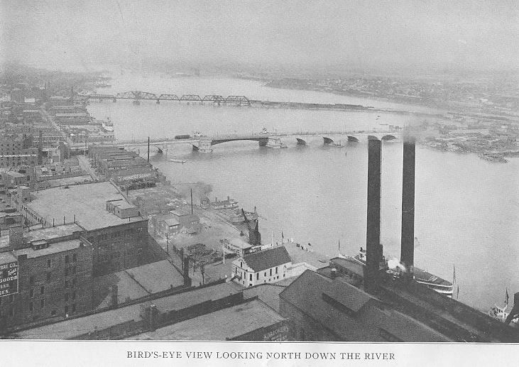
The principal watercourses are the Maumee and Ottawa rivers, Swan and Ten-mile creeks. The Maumee forms part of the boundary line between Lucas and Wood counties. From the foot o fthe rapids to the Maumee Bay it divides Lucas County into two unequal portions, leaving Oregon and Jerusalem townships on the east. It has its source at Fort Wayne, Indiana, where it is f ormed by the confluence of the St. Joseph and St. Mary's rivers. From Providence, near the southwest corner of the county, to Maumee it falls about sixty feet in a series of cascades, forming what are known as the "Maumee Rapids." From the foot of these rapids to Lake Erie the river is navigable for boats of considerable size. The largest lake steamers easily ascend the Maumee to Toledo, giving the city one of the best harbors on the Great Lakes.
The Ottawa River is formed in Sylvania Township by the junction of Bear and Ten-mile creeks. At first it flows in a southeasterly direction, then turns toward the northeast, and empties into the Maumee Bay near the boundary between Ohio and Michigan. The name "Ten-mile Creek" is sometimes given to that portion of the stream flowing through Adams and Washington townships and the northern part of the City of Toledo.
Swan Creek rises in Fulton County and follows a southeasterly course until near the Village of Whitehouse, in Waterville Township. It then runs almost parallel to the Maumee to the western boundary of Adams Township, when it turns more to the eastward and falls into the Maumee near the foot of Monroe Street in the City of Toledo. This creek, with Ten-mile, Bear, Sibley and Jacob creeks and a few smaller streams afford fairly good drainage for that part of the county lying north
- 15 -
16 - TOLEDO AND LUCAS COUNTY
west of the Maumee River, though in some localities it was found necessary to resort to artificial drainage before the land could be profitably cultivated.
Most of that portion of the county southeast of the Maumee lies in what is known as the "Black Swamp" district. This section is drained by small streams that empty into Lake Erie. The most important of these are the Crane, Cedar and Wolf creeks and the "Big Coolee."
THE MAUMEE RIVER
On the early French maps of the Great Lake region, the name of this stream appears as "Miami du Lac," the English translation of which is the "Miami of the Lake." In early Indian treaties and other old documents relating to this section of the country, frequent reference is found to the "Miami of Lake Erie," or the "Miami of the Lakes," these terms being used to distinguish the river from the Miami which empties into the Ohio River near the southwest corner of the State of Ohio. There can be no doubt that the name was derived from the Miami Indians. The word was pronounced by the French as though spelled "Mee-ah-mee," with the accent on the second syllable. During the War of 1812, the American soldiers, unfamiliar with the French language, slurred the vowel in the first syllable and broadened the sound of the "a" in the second. This resulted in the pronunciation of the word as though spelled "Mau-mee," which in a short time became generally recognized as the name of the river.
On November 7, 1855, an effort was made by some of the citizens of the City of Toledo to change the name of the river. A public meeting was field on that date, with S. J. Kuder as chairman and W. M. Scott acting as secretary. A resolution was introduced, the preamble of which set forth that the early associations of the river, "aided by a poet's wit," had given the river, the bay at the mouth thereof and the valley "an unjust and unfavorable reputation." It was therefore "Resolved, that the Maumee River and the Maumee Bay be hereafter known as the Grand Rapids River and the Grand Rapids Bay, and that the local press of the Grand Rapids Valley be requested to publish the proceedings of this meeting."
The meeting proved to be as barren of results, however, as that of the tailors of Tooley Street. The name Maumee was too firmly established to be changed by a resolution adopted by a few individuals. It is quite probable that the "poet's wit" alluded to in the resolution related to some verses published in the "Maumee City Express" of June 24, 1837. There are no doubt old residents who may be able to recall the meeting of 1855 and the rhymes referred to, but for the benefit of the present generation the poem is here reproduced :
"On Maumee, on Maumee,
Potatoes they grow small ;
They roast them in the fire
And eat them—tops and all.
"There's Bass and Mullet, too ;
They run from Spring till Fall ;
They take them by the tail
And down them—scales and all.
TOLEDO AND LUCAS COUNTY - 19
"There's 'possum, coon and fox,
So poor they scarce can crawl ;
They catch them in a trap
And eat them—fur and all.
"There's crow upon the bank,
So lean they never squall ;
They shoot them through the eye
And take them—down and all.
"The soil is rich and black,
The corn it grows quite tall ;
They take it from the field
And eat it—cobs and all.
"On New Year's holiday,
The chaps they have a ball ;
'Tis whiskey in a gourd ;
They drink it—gourd and all.
"The girls are plump and fair,
The babes know how to bawl ;
The boys they always court
The girl, mam, dad and all.
"On Maumee, on Maumee,
'Tis Ague in the Fall ;
The fit will shake them so
It rocks the house and all.
"There's a funeral every day,
Without a hearse or pall ;
They tuck them in the ground,
With breeches, coat and all."
GEOLOGY
The first geological survey of Ohio was authorized by the Legislature of 1837 and Prof. William W. Mather, formerly connected with the geological survey of New York, was appointed state geologist. His work was abruptly terminated before Lucas County was reached and no report was ever published. By the act of April 3, 1869, the Legislature provided for a complete geological survey of the state. Prof. J. S. Newberry was appointed chief of the survey. Under the provisions of this act the first reports on the geology of Lucas County were made in 1870 and 1871.
From these reports it appears that the oldest rocks in the county are those belonging to the Helderherg series of the Lower Devonian age. Between Provi-
20 - TOLEDO AND LUCAS COUNTY
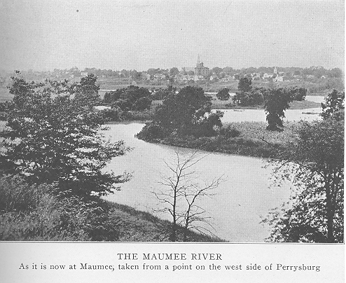
dence and the foot of the rapids the Maumee River flows over ledges of the Lower Helderberg formation. At Maumee, the head of slack water, a ledge of this limestone forms what is known as the "Rock Bar" across the river, only a few feet below the surface at low water. From this bar to Lake Erie the bottom of the river is composed of clay and sand.
At Roche de Boeuf, about a mile above Waterville, a Waterlime exposure forms a bluff about thirty feet in height. Here may be seen the remains of an old channel, which makes a detour from the left bank of the river around a portion of the bluff. This portion was no doubt at one time an island. Two miles below 'Waterville similar phenomena are to be seen. At this point the isolated portion of the bluff is known as Presque Isle—a name given to it by the early French.
Outcrops of the Niagara limestone, of the Upper Silurian age, in Ottawa County near the Lucas County line, have led geologists to believe that this stone underlies a large part of Oregon and Jerusalem townships, southeast of the Maumee River, but no exposures occur in the county. Concerning the Lower Helderberg series in Ohio, Prof. Edward Orton, of the Ohio Geological Survey, says :
"The interval that exists between the Niagara and the Devonian limestones is occupied in Ohio by a very important formation. It is filled with a series of beds, which are in part at least the equivalents of the Waterlime of New York. The name is unhappily chosen. Strictly applicable to only an insignificant fraction of the beds of this series in New York, we are still obliged to apply the designation Water-lime, with its misleading suggestions, to all deposits of the same age throughout the country. Though the last to be recognized of our several limestone formations, the Waterlime occupies a larger area in Ohio than any other, its principal developments being found in the drift-covered plains of the northwestern quarter of the state. . . . The surface of many successive layers at numerous points is covered with sun-cracks, thus furnishing proof of having been formed in shallow water .near the edge of the sea. In such localities the beds are usually quite thin, and are also impure in composition. In these respects it suggests the conditions of the Onondaga salt group of New York. It is frequently a nearly pure dolomite in composition and accordingly it yields magnesian lime of high quality, and is extensively burned in the state, rivaling in this respect the Guelph beds of the Niagara group."
In Lucas County this so-called Waterlime is exposed in a number of places. Besides the ledges forming the bed of the Maumee River, already mentioned, it is exposed in the bed of Swan Creek at the village of Monclova, in the northern part of Monclova Township, in the Ten-mile Creek in Sylvania Township, on the plain near Maumee, and at several other points. At Maumee, Monclova and Waterville it has been utilized to some extent in the manufacture of lime, the Geological Report for 1870 stating that 40,000 bushels had been burned in 1869. It consists of two layers, the lower of which is designated as Waterlime and the upper as Corniferous limestone. Through the townships of Monclova, Springfield, Sylvania and Water,. ville, the surveyors found a bed of Oriskany sandstone underlying the Corniferous and resting upon the Waterlime.
From an economic standpoint, the Helderberg limestones constitute the most important geological formation in the county. All the members of this group are exposed in a rocky ridge about two miles west of the village of Sylvania. A section here shows the following arrangement—from the top downward
TOLEDO AND LUCAS COUNTY - 21
SERIES