TOLEDO AND LUCAS COUNTY - 125
City of Fremont, Ohio, now stands, was garrisoned by 150 men, commanded by Maj. George Croghan, only a little past twenty-one years of age. The fort was considered too weak to withstand an assault by heavy artillery, such as Proctor was supposed to have, and on the last day of July Harrison—then at Fort Seneca, about ten miles south of Fort Stephenson—sent Croghan an order to abandon it. Before the order could be carried out, Proctor's army was seen coming up the Sandusky River in open boats. At the same time Croghan learned that a large body of Indians had been sent to the rear to cut off his retreat. Proctor trained his six pieces of artillery (fortunately all light guns) upon the northwest angle of the fort and then demanded a surrender, resorting to his old story that resistance would only exasperate the Indians and lead to a massacre. But Croghan's Irish fighting blood was up and he sent back word that when Proctor got possession of the fort there would be nobody inside for him to massacre. For twenty-four hours Proctor's cannon kept pounding away at that northwest angle, his aim being to effect a breach through which his Indians could pass to begin their butchery. Croghan and his men worked like ants to strengthen the angle with sacks of sand, but he saw that the constant bombardment was doing the damage faster than he could make repairs. He had but one cannon—an old six-pounder—which he located so as to rake the opening, loaded it heavily with slugs and calmly waited for the assault.
About dark on the evening of August the 2nd, Proctor ordered a column of 350 men to force its way through the breach and into the fort. When within twenty yards of the walls the assailants were greeted by a volley of musketry that killed and wounded several, but failed to check the advance. Then the little six-pounder, aimed low, was discharged, sending its rain of slugs into the enemy's rank. This seemed to be enough for the British soldiers, who broke and fled in confusion, leaving twenty-seven dead in the ditch surrounding the fort. No further attack was made and the next morning Proctor hurriedly withdrew, leaving his guns and stores. Fort Stephenson was saved without the loss of a man and Major Croghan became one of the heroes of the war.
PERRY'S VICTORY
In the meantime General Harrison had decided to postpone further offensive operations until the completion of the ships that Commodore Oliver Hazard Perry was building on Lake Erie. On the last day of July he was joined by Gov. Isaac Shelby, of Kentucky, with 3,500 men from that state, eager to avenge the massacre of so many of their comrades at the River Raisin. Early in September, 1813, Perry's fleet was at Put-in-Bay ready for action. On Gibraltar Island there is a bold headland which commands a view of the Bass Islands and the passage to the mouth of the Detroit River. Here Perry stationed a watch to notify him if the British fleet appeared. This headland is still known as "Perry's Lookout."
The British fleet lay in the Detroit River in front of Fort Malden. It was commanded by Capt. Robert H. Barclay, who had f ought with Nelson at Trafalgar. On the morning of September 9, 1813, Henry Brevoort, of Detroit, gave Perry the names and positions of the British ships. Perry immediately called his officers together and gave them his plan of battle. Perry had nine vessels
126 - TOLEDO AND LUCAS COUNTY
mounting fifty-four guns and two swivels. The British fleet numbered only six vessels, but they carried sixty-three guns, one pivot-gun, two swivels and two howitzers. Thus, while Perry had the advantage in the number of ships, Barclay had an advantage in the strength of his armament. Perry's plan was for each of six largest ships to engage one of the British vessels, the three smaller ones to render assistance at such times and places as it was most needed. He also instructed his officers to be ready to sail early on the following morning, as it was his intention to engage Barclay in the Detroit River if he failed to come out upon the lake.
Soon after sunrise on the morning of the 10th the lookout on the headland signaled that the British ships were coming out of the Detroit River. Immediately all was activity on the American vessels. For the first time a great pennant, hearing the motto "DON'T GIVE UP THE SHIP," in letters large enough to he seen by all the sailors, was run up to the masthead of the "Lawrence," Perry's flagship. As the morning breeze caught this pennant and the men saw the inspiring motto, a mighty cheer arose from the ships as they sailed out to meet the enemy. Within a short time the two fleets were engaged and it is said the thunder of the guns could be heard at Cleveland, seventy miles away. Perry's plan was working well until the "Lawrence" was disabled. Every American, familiar with his country's history, knows how Perry then crossed over in a small boat to the "Niagara," under the fire of the British guns, and won a decisive victory. About noon he sent, his famous message to General Harrison: "We have met the enemy and they are ours ;" two ships, two brigs, one schooner and a sloop."
One of the brigs captured was the "Adams," which had been surrendered by General Hull the year before. It had been overhauled by the British and rechristened the "Detroit." This was the first time in history that an entire British fleet was captured in a naval engagement. Perry's victory was one of the important events of the war. It removed Proctor's greatest support. At the time of the action he had a force of 5,000 British and Indians at Malden, waiting only for Barclay to sustain the traditions of the English navy, to overrun the frontier. But Barclay failed to sustain those traditions and Proctor was forced to change his plans.
BATTLE OF THE THAMES
General Harrison was at Sandusky Bay, ready to recapture Detroit and invade Canada if Perry won the battle on Lake Erie. As soon as he heard the result of the engagement his army was on the move. Perry spent a few days repairing his ships, when Harrison's troops embarked and were carried to Malden, where they arrived on September 27, 1813, to find that the enemy had evacuated the post the day before, after destroying the stores and most of the buildings in the fort. The Americans at once began making preparations for a pursuit. On the 29th Colonel McArthur crossed the river and occupied Detroit with his brigade of 700 men, while the rest of the army camped that night in Sandwich. The next day Harrison was joined by Col. Richard M. Johnson's regiment from Fort Meigs, which gave the American commander 3,500 men.
In the retreat, Proctor halted several times, only to move on before the Ameri-

TOLEDO AND LUCAS COUNTY - 129
cans could attack. It is said that Tecumseh called him a coward and threatened to take his Indians away from the army, upon which Proctor promised the chief that he would make a stand at Chatham. On the afternoon of October 5, 1813, he formed his line of battle across the road, his right resting on the River Thames, with Tecumseh and his Indians on the left. Harrison's army advanced in perfect order until the bugles sounded the charge, when Colonel Johnson's mounted troops hurled themselves like an avalanche against the enemy's line. General Shelby sent part of his men, under Lieut.-Col. John Donaldson, to Johnson's support and in a little while the war-cry of the Kentuckians, "Remember the Raisin," could be heard above the din of the battle. The impetuous onslaught was too much for the Indians, who fled in all directions, pursued by the victorious Kentuckians. Tecumseh was killed in this engagement by a pistol shot fired by Colonel Johnson, after the latter was wounded. After a brief fight the British regulars surrendered, though General Proctor succeeded in making his escape in a carriage and the next day was sixty-five miles from the scene of the battle. The battle of the Thames ended the war in the Northwest, though the post at Michilimackinac was not surrendered until after the Treaty of Ghent in December, 1814, which brought the return of peace.
MARKING HISTORIC SITES
On July 28, 1885, the Maumee Valley Monument Association was incorporated "to survey, mark and preserve historic sites." In 1888 0. M. Poe, colonel of engineers, reported favorably upon the purchase by the United States of. a portion of the battlefield of Fallen Timbers and the erection of a monument, but nothing was done. In 1899 the Monument Association was succeeded by the Maumee Valley Pioneer and Historical Association. This organization in 1903 acquired title to a small tract of land including Turkeyfoot Rock. The aim was to get the entire battlefield of Fallen Timbers and convert it into a park, but the association was unable to raise the necessary funds to carry out the project.
Early in the year 1922, during what was known as "Talk Toledo" week, interest in the subject of marking historic places near the city was revived and a movement was started to have the Federal Government accept the forty-four acres comprising the site of Fort Meigs, provided the Ohio Legislature would relinquish the state's right, then purchase the battlefield of Fallen Timbers and make the whole a part of the national park system. During that week temporary markers were erected by the Toledo Automobile Club on the site of 'old Fort Miami, Wayne's battlefield, the scene of Colonel Dudley's defeat, and the site of Fort Meigs. The respective inscriptions on these markers were as follows :
FORT MIAMI
Established as a French trading post in 1680. Erected as a fort by the British in 1794 and surrendered to the United States in 1796. It was here that the survivors of Colonel Dudley's forces who had been ambushed by Indians during the first siege of Fort Meigs in May, 1813, were compelled to run the gauntlet and were being brutally tomahawked in sight of General Proctor, until Tecumseh,
130 - TOLEDO AND LUCAS COUNTY
the great Indian chief, compelled the Indians to stop their slaughter. After Wayne's victory at the battle of Fallen Timbers, August 20, 1794, he drove the enemy to within eighty yards of the gates of this fort.
BATTLEFIELD OF FALLEN TIMBERS
On August, 20, 1794, General Anthony Wayne, commanding an army of about 3,000, defeated at this place and completely routed the Indians of the Northwest under command of Chiefs Blue Jacket and Little Turtle. The Indians were pursued as far as Fort Miami.
DUDLEY'S BATTLEFIELD
On May 5, 1813, during the first siege of Fort Meigs, Colonel Dudley and 800 Kentucky militia captured the British batteries and spiked the guns. While swiftly pursuing the enemy into the woods, the brave Kentuckians were ambushed by Indians. Only 150 escaped the others having been killed or captured. The prisoners were taken to Fort Miami.
FORT MEIGS
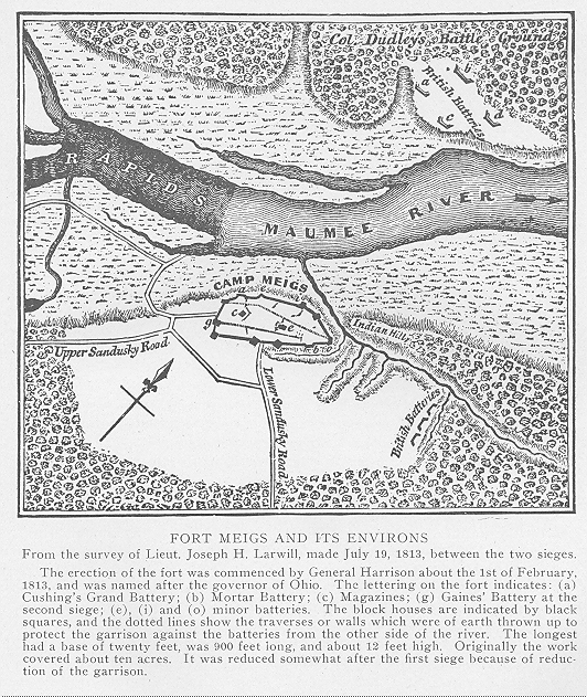
The first siege of Fort Meigs was May 1 to 9, 1813. Attacked by General Proctor with 3,200 British and Indians, it was successfully defended by General Harrison with 1,200 Americans. Besieged again July 21 to 27, 1813, by General Proctor and 500 English and Indian allies, who were repulsed by General Clay and several hundred Americans.
Steps were also taken during the "Talk Toledo" week, by the city council and the Sons of the American Revolution, to place a bronze tablet upon the wall of one of the buildings at the corner of Monroe and Summit streets, bearing this inscription :
FORT INDUSTRY
was erected on this site by order of General Anthony Wayne just after the battle of Fallen Timbers on August 20, 1794, as a defense against the British, who occupied Fort Miami.
RECAPITULATION
In this and the preceding chapters have been narrated many events, which may appear to have little or no connection with the history of Toledo and Lucas County. More than three centuries elapsed between the discovery of America and the close of the War of 1812. During all this period few attempts were made to establish permanent white settlements in the lower Maumee Valley, which remained a
TOLEDO AND LUCAS COUNTY - 131
"howling wilderness." Under the papal grant of 1493, the country about the Great Lakes became the property of Spain. Through the proclamations of St. Lusson in 1671 and La Salle in 1682, the entire present State of Ohio was recognized as part of the French possessions in America. By the treaty of February 10,' 1763, which ended the French and Indian war, all French territory east of the Mississippi was ceded to Great Britain.
Thus the site of Toledo was successively in Spanish, French and English territory. At the close of the Revolutionary war England surrendered to the United States, title to all the region south of the Great Lakes and east of the Mississippi River. Then followed a series of troubles with the Indians, in which they were upheld by the British. The Indians were finally defeated by Gen. Anthony Wayne at the battle of Fallen Timbers, which resulted in the British evacuation of the posts within the region ceded to the United States by the treaty of September 3, 1783. In the meantime the Northwest Territory had been created by act of Congress, in which was included the present Lucas County. In 1796 it was made a part of Wayne County. Then came the War of 1812, which was followed by treaties with the Indian tribes, by which the lands in Northwestern Ohio became a part of the public domain of the United States. The preparatory period was now at an end and the era of actual settlement and progress was inaugurated.
CHAPTER X
THE BOUNDARY WAR
EXTENT OF TERRITORY INVOLVED-ORIGIN OF THE TROUBLE-DEFECTIVE MAPS-OHIO ENABLING ACT-BOUNDARY AS FIXED BY THE OHIO CONSTITUTION- SPAFFORD'S LETTER-THE HARRIS LINE-MICHIGAN'S MEMORIAL-THE FULTON LINE -THE CANAL QUESTION-THE WAR BEGINS-PRESIDENT JACKSON INTERVENES -AN INTERRUPTED SURVEY- EXTRA LEGISLATIVE SESSIONS- GOVERNOR LUCAS APPEALS TO JACKSON- FURTHER "OUTRAGES"-A MIDNIGHT COURT SESSION-GOVERNOR MASON REMOVED-END OF THE WAR-CONGRESS COMPROMISES THE QUESTION- TOLEDO CELEBRATES.
That portion of Lucas County involved in the controversy between the State of Ohio and the Territory of Michigan over the boundary line, included the present City of Toledo, the townships of Jerusalem, Oregon, Richfield, Sylvania and Washington, and the northern portions of Adams, Spencer and Springfield—about two-thirds of the county.
ORIGIN OF THE TROUBLE
The beginning of the controversy and the causes therefor may be found in the Ordinance of 1787, which created the Northwest Territory and provided for its division into not fewer than three nor more than five states. If divided into only three states, the Ordinance fixed the boundaries of each, to wit : The western state was to include all that portion west of a line beginning at the mouth of the Wabash River ; thence up that stream to a place where a line drawn due north from Vincennes last touches the river ; thence due north to the territorial line. This state would have included the present states of Illinois and Wisconsin, the greater part of the upper peninsula of Michigan, and that part of Minnesota east of the Mississippi River. The middle state was to embrace that portion lying east of the above described line and west of a line beginning at the mouth of the Great Miami River and running due north to the territorial line. It would have included the present State of Indiana and the western half of Michigan. The eastern state was to consist of the remainder of the Northwest Territory, i. e., the present State of Ohio and the eastern half of Michigan.
If the Ordinance had stopped there, the chances are that no dispute over boundary lines would ever have occurred. But in making provision for five states, Congress was given authority to create the two additional states from that part of the territory situated north of an "east and west line drawn through the southerly bend or extremity of Lake Michigan." In that provision lay the germ of the dispute. At the time the Ordinance was passed, the geography of the country about the Great lakes was imperfectly understood. By referring to Joliet's map, in an
- 133 -
134 - TOLEDO AND LUCAS COUNTY
earlier chapter of this history, it will be seen that the southern extremity of Lake Michigan (called Lac des Illinois by Joliet) is shown quite a distance north of the mouth of the Maumee River, where it enters Lake Erie. For many years this map was regarded as the best geographical authority on the Great Lakes region. In fact, as late as 1780—only seven years before the passage of the Ordinance—Mitchell & Bradley copied Joliet's error in their Atlas, which was the authority used by Congress in the preparation of the section above quoted. Judge Jacob Burnet, in his "Notes on the Northwest Territory," says :
"It is generally known to those who have consulted the maps of the western country extant at the time the Ordinance of 1787 was passed, that Lake Michigan was represented as being far north of the position which it has since been ascertained to occupy. On a map of the Department of State, which was before the committee of Congress who framed the Ordinance for the government of the Territory, the southern boundary of that lake was laid down as being near the forty-second degree of north latitude, and there was a pencil line passing through the southern bend of the lake to the Canada line, which intersected the strait (Detroit River) between the River Raisin and the Town of Detroit. That line was manifestly intended by the committee and by Congress to be the northern boundary of this state (Ohio), and, on the principle on which courts of chancery construe contracts, accompanied with plats, that map and the line marked on it should have been taken as conclusive evidence of the boundary, without reference to the actual position of the southern extreme of the lake."
OHIO ENABLING ACT
On April 30, 1802, President Jefferson approved an act of Congress authorizing the people of Ohio to form a constitution and state government, preparatory to admission into the Union. In fixing the boundaries of the proposed state, the Enabling Act described the northern boundary as "an east and west line drawn through the southerly extreme of Lake Michigan, running east, after intersecting the due north line from the mouth of the Great Miami River, until it shall intersect Lake Erie, or the territorial line, and thence with the same through Lake Erie to the Pennsylvania line." Three years later, January 11, 1805, President Jefferson approved the act of Congress erecting the Territory of Michigan, the southern boundary of which was described as "a line drawn east from the southern end of Lake Michigan to Lake Erie." In both the Ohio Enabling Act and the act creating Michigan Territory, it is clearly shown that Congress intended the line between the two to be farther north than was afterward claimed by Michigan. In both acts Lake Erie is designated as the eastern terminus of the line, or after striking Lake Erie it was to follow the international boundary through to the Pennsylvania line. If Michigan's contentions had been sustained, the dividing line would not have intersected the international boundary at any point. Running due east from the southern extremity of Lake Michigan, it would not have struck Lake Erie until more than thirty miles east of the Maumee River. Continuing east, it would have come to land again near Cleveland, which would have thrown a small triangle in northeastern Ohio into the Territory of Michigan—a situation certainly never intended by Congress.
While the Ohio constitutional convention was in session in 1802 at Chillicothe,
TOLEDO AND LUCAS COUNTY - 135
a hunter who had spent many years in the vicinity of Lake Michigan and knew its location better than the geographers, informed some of the delegates that the lake extended much farther south than was generally supposed. He even pointed out on an old map the true position of the southern end of the lake, according to the knowledge he had gained by experience. His statement produced some apprehension among the members of the convention and led to the adoption of an amendment to the provision relating to the northern boundary, viz : "If the southerly bend or extreme of Lake Michigan should be found to extend so far south that a line drawn due east from it should not intersect Lake Erie, or if it should intersect the said Lake Erie east of the mouth of the Miami River of the Lake (the Maumee), then and in that case, with the assent of the Congress of the United States, the northern boundary of this state shall be established by, and extended on, a direct line running from the southern extremity of Lake Michigan to the most northerly cape of the Miami (Maumee) Bay," etc.
The object of this proviso was to save to the State of Ohio the valuable harbor of the Maumee River and Bay, as was doubtless intended by Congress in the Enabling Act. Congress accepted the constitution adopted by the Chillicothe convention, but did not give express assent to the alternate boundary as above set forth. Michigan afterward claimed that the Ordinance of 1787 was a solemn compact and that the assent of Congress could not be implied, but must be definitely stated. In the dispute which followed, Ohio argued from the standpoint of equity, while Michigan adhered strictly to the legal phase of the question—that the Ordinance of 1787 was to "forever remain unalterable, unless by common consent," and that common consent had never been given to a change.
SPAFFORD'S LETTER
Without consulting anybody, Michigan proceeded to exercise jurisdiction over the territory as far south as a "line extended due east from the southern extremity of Lake Michigan." The first intimation of trouble did not come until about seven years after Michigan had been established as a territory. Then Amos Spafford wrote the following letter to Return J. Meigs, governor of Ohio :
"Miami Rapids, January 23, 1812.
"Sir :—It appears to be the general wish of the people in this settlement (which consists of about fifty families), to have the laws of the State of Ohio over them, as we consider ourselves clearly within the limits of said state. The few who object are those who hold offices under the government of Michigan and are determined to enforce their laws. This is considered by a great majority of the inhabitants as usurpation of power which they are under no obligation to adhere to. If no adjustment should take place, I fear the contention will ere long become serious.
"Sir, will you have the goodness to inform the people here whether there has been any understanding between the State of Ohio and the government of Michigan on the subject of jurisdiction, together with your advice ?
"I am, sir, with high esteem,
Your most obedient servant,
"Amos SPAFFORD,
"Collector of Port Miami."
136 - TOLEDO AND LUCAS COUNTY
Governor Meigs: reply to this letter, if a reply was made, is not known. It is probable that he referred the matter to Congress, as that body on May 20, 1812, passed an act authorizing the President to ascertain and designate certain boundaries, including the one between Ohio and Michigan Territory. But the unfriendly relations between the United States and .Great Britain overshadowed all questions of local significance and united the people of the frontier, including those in the disputed territory, in support of the Federal administration. In that act of May 20, 1812, the surveyor-general of the United States was directed, as soon as the consent of the Indians could be obtained, "to cause to be surveyed, marked and designated, so much of the western and northern boundaries of the State of Ohio, which have not already been ascertained, as divides said state from the territories of Indiana and Michigan, agreeably to the boundaries as established by the act of April 30, 1802. . . . And to cause to be made a plat or plan of so much of the boundary line as runs from the southerly extreme of Lake Michigan to Lake Erie, particularly noting the place where said line intersects the margin of said lake, and to return the same when made to Congress."
Here the whole matter rested until after the War of 1812 was over. On August 22, 1816, the commissioner of the general land office ordered the surveyor-general "to engage a skillful deputy to mark the said northern boundary of Ohio, in accordance with the act of May 20, 1812."
THE HARRIS LINE
In 1817, treaties of peace having been concluded with the Indians, Edward Tiffin, surveyor-general of the United States, pursuant to the order of the commissioner, appointed William Harris to run a portion of the western and all of the northern boundary of Ohio. Indiana had been admitted as a state in December, 1816, and Congress, in defining its northern boundary designated "a line running due east from a point on the shore of Lake Michigan ten miles north of said lake's most southern bend or extremity." This took a strip of land ten miles wide from the southern border of Michigan Territory, if the provisions of the Ordinance of 1787 were to be strictly observed. By thus extending Indiana ten miles farther north, Congress showed its disregard for the Ordinance and gave to the Ohio claimants another argument to help them sustain their position. Harris found that a due east line from the most southern point of Lake Michigan would intersect Lake Erie seven miles south of the most northerly cape of the Maumee Bay. He therefore ran a second line, in accordance with the provisions of the Ohio constitution, to the most northerly cape of the bay and reported accordingly.
This line established the northwest corner .of Ohio at a point on the Indiana line, five miles, twenty-four chains and sixty-four links north of where the due east and west line from the head of Lake Michigan would have located it. Willard V. Way, writing in 1869, says : "The territory in dispute extends the whole length of the north line of the State of Ohio about five miles in width at the west end and about eight miles in width at the east end. It is valuable chiefly for its rich and productive farming lands, and for the possession of the harbor on the Maumee River, where now stands the flourishing City of Toledo."
At the time Mr. Harris made his survey, Lewis Cass was the governor of
TOLEDO AND LUCAS COUNTY - 137
Michigan Territory. Under date of November 1, 1817, he sent the following protest to Surveyor-General Tiffin : "Report says that the line which has been recently run, purporting to be the line between the State of Ohio and this Territory, was not run a due east course from the southern extremity of Lake Michigan to Lake Erie, but a course somewhat to the north of this, although how much I am unable to ascertain. The act of Congress organizing the Territory of Michigan makes its southern boundary a due east line from the southern extremity of Lake Michigan. and this act is in strict conformity with the fifth of the articles of compact in the ordinance for the government of the Northwest Territory ; these are declared to be unalterable except by mutual consent."
MICHIGAN'S MEMORIAL
Several letters were exchanged between Governor Cass and the surveyor-general, the latter upholding the survey made by Mr. Harris as being in accordance with the acts of April 30, 1802, and May 20, 1812. While this correspondence was going on the Ohio Legislature took a hand by adopting strong resolutions, affirming the Harris line as the true one, and strictly in harmony with the action of Congress in accepting the Ohio constitution and admitting the state into the Union.
On January 3, 1818, the governor and judges of the Territory of Michigan came back with a memorial to Congress, in which they reviewed the provisions of the Ordinance of 1787, the Ohio Enabling Act and the Ohio constitution, after which they continued :
"Your memorialists beg leave to state that during the past summer a line was run, under the direction of the surveyor-general, intended to be the boundary between this Territory and the State of Ohio. This line, instead of being on an east and west line from the southern extremity of Lake Michigan, agreeably to the acts of Congress before mentioned, was run on a course north 87 degrees 42 minutes east, and strikes Lake Erie at the northern cap of Miami Bay, taking from the southern boundary of this Territory seven miles and forty-nine chains and adding it to the State of Ohio. The legislative power of this Territory is by law vested in your memorialists and they conceive they would fail to discharge the duties of their station were they not to submit this subject to the consideration of the National Legislature.
"The undersigned therefore respectfully submit the subject of this memorial to the consideration of Congress and pray that the boundary line between this Territory and the State of Ohio may be run and established agreeably to the Ordinance of Congress' of 1787, and the several acts of Congress heretofore passed upon the subject."
The memorial was signed by Lewis Cass, governor ; Augustus B. Woodward, John Griffin and James Witherell, judges. It produced the desired effect, for on June 24, 1818, William H. Crawford, then secretary of the treasury, directed the' commissioner of the general land office "to have the northern boundary of Ohio run and marked in conformity with the act of May 20, 1812—that is, on a due east and west line."
138 - TOLEDO AND LUCAS COUNTY
THE FULTON LINE
Pursuant to Mr. Crawford's instructions, John A. Fulton was employed to make the new survey. He did not determine the latitude of the southern extremity of Lake Michigan, but began at the present northwest corner of Ohio, where the Harris line east from that lake intersected the north and south line between the states of Indiana and Ohio. Neither did he establish the latitude where the line crossed the Maumee River, nor where it intersected the shore of Lake Erie. His plat showed variations of latitude at various points along the line. Notwithstanding these discrepancies, when the United States came to survey the lands purchased of the Indians, a few years later, the Fulton line was accepted as a base for the formation of townships, ranges and sections. This gave the people of Michigan an opportunity to gloat over their victory.
The Fulton line ran a few rods north of the southern boundary of Jerusalem and Oregon townships, Lucas County, and continued west through the townships of Adams, Springfield and Spencer. Had it been finally accepted, the City of Toledo and more than half of Lucas County would now be in the State of Michigan. In such case it is not likely there would have been any Lucas County, and Toledo would have been merely the tail of Detroit's kite.
Ohio, however, refused to accept the Fulton survey and proceeded, wherever the population was sufficient, to organize townships, etc. Both claimants endeavored to exercise jurisdiction by the appointment of local officials, levying taxes, etc., but nothing serious occurred for several years, during which the inhabitants of the disputed strip lived in a state of suspense. Duplicate copies of the Harris and Fulton surveys were forwarded to the secretary of the treasury in March, 1820, and one copy of each was transmitted by him to the President. There the whole matter rested until the Michigan authorities erected Port Lawrence Township in the spring of 1827. This again brought the boundary question before Congress and on March 18, 1828, the committee on territories of the House of Representatives submitted recommendations that the correct latitude of the several points on the Fulton line be accurately determined. Here Ohio gained a slight advantage, as the recommendations of the committee admitted the errors in the Fulton survey.
THE CANAL QUESTION
During the administration of President John Quincy Adams a great interest in internal improvements was manifested all over the country. Among the projects undertaken or proposed was that of connecting Lake Erie and the Ohio River by canals along Maumee and Wabash rivers. In March, 1827, Congress granted to the State of Indiana each alternate section of land in a strip ten miles wide along the line of the proposed canal. Andrew Jackson succeeded Adams on March 4, 1829. He was opposed to the policy of internal improvements by the General Government, but the land grant for the Miami and Wabash canal remained valid and Indiana conveyed to Ohio that portion of the grant situated within the latter state. In this way Ohio became interested and in March, 1834, the Legislature authorized Governor Lucas to appoint three commissioners to locate the line of the canal through the state. A survey of the canal route was made in that year and it
TOLEDO AND LUCAS COUNTY - 139
was found that the eastern terminus would have to be at a point on the Maumee River north of the Fulton line, in order to reach navigable water. (For a history of this canal see chapter on Transportation.)
When it became known that the terminus of the canal would have to be within the limits of the disputed territory, the boundary question became the one topic of discussion and the partisans of the rival claimants reached a state of almost frenzied excitement. The people of Michigan would have liked to have the canal constructed, but Ohio owned the land grant to pay for it, and it was not probable that the state would use the land to build a canal, the terminus of which would be in Michigan territory. In Chapter XVII is told how Benjamin F. Stickney and other residents of the disputed territory, who were at first inclined to favor Michigan's claims "changed front" when the canal question came up for consideration. On December 26, 1834, the Territorial Legislature of Michigan passed an act providing for the appointment of three commissioners to "negotiate and settle all questions in regard to the southern boundary of the territory," and recommended that Ohio be requested to cooperate.
THE WAR BEGINS
Gov. Robert Lucas, in his message to the General Assembly on February 6, 1835, said : "I have received from the acting governor of the Territory of Michigan a communication inclosing a copy of an act passed by the Legislative Council of the territory, providing for the appointment of commissioners to adjust the boundary between that territory and the State of Ohio. In the present case we cannot admit that the Legislative Council of the Territory of Michigan had any right to authorize a negotiation on the subject of a boundary, or that any arrangement entered into with commissioners appointed under their authority would be binding, even on Michigan herself, after she might become an independent state .. . . I would therefore recommend the passage o f an act declaring that all counties bordering on the northern boundary of the State of Ohio shall extend to and be bounded on the north by the line running from the southern extremity of Lake Michigan to the most northern cape of the Maumee Bay, and that the county and township officers within these counties and townships be directed to exercise jurisdiction within their respective counties and townships thus extended."
When news of this action on the part of the governor reached Detroit, the Michigan Legislative Council sought to intimidate the Ohio Legislature from acting upon the recommendation by passing an act "to prevent the exercise of foreign jurisdiction within the limits of the Territory of Michigan." Heavy fines and imprisonment were provided by the act for any person who should "exercise or attempt to exercise any official functions within the limits of this territory, or any county thereof, by virtue of any commission or authority not derived from this territory, or from the United States," or any person who should accept office from any authority other than the Territory of Michigan or the United States. The Ohio Legislature promptly "called the bluff" and on February 23, 1835, Governor Lucas approved an act extending the Ohio jurisdiction to the Harris line, reestablishing Port Lawrence Township and erecting the Township of Sylvania. The act also provided for the appointment, of three commissioners to resurvey and mark
140 - TOLEDO AND LUCAS COUNTY
the Harris line. John Patterson, of Adams County, Jonathan Taylor, of Licking, and Uri Seely, of Geauga, were appointed and instructed to begin their work on the first of the following April.
The fight was now on in earnest. On March 9, 1835, Stevens T. Mason, governor of Michigan Territory, addressed the following communication to Gen. Joseph W. Brown, commanding the Third Division of the Michigan militia :
"Dear Sir :—You will perceive that a collision between Ohio and Michigan is now inevitable, and you will therefore be prepared to meet the crisis. The governor of Ohio has issued a proclamation, but I have neither received it, nor have I been able to learn its tendency. You will use every exertion to obtain the earliest information of the military movements of our adversary, as I shall assume the responsibility of sending you such arms, etc., as may be necessary for your successful operation, without waiting for an order from the secretary of war, so soon as Ohio is properly in the field. Till then, I am compelled to await the direction of the war department."
General Brown issued an order for the transportation of arms and ammunition to Monroe ; appointed Henry Smith, division inspector ; Daniel S. Bacon, division paymaster ; Charles Noble, aide-de-camp, and issued an address to the Michigan militia, in which he stated that "If there is an officer in the Michigan militia, who hesitates to stake life, fortune and honor in the struggle now before us, he is required promptly to tender his resignation, in order that his place may be more efficiently filled. . . . We Are determined to repel with force whatever strength the State of Ohio may attempt to bring into our territory to sustain her usurpation, and let the consequences which may follow rest on the guilty heads of those who attempt to deprive us by force of our rightful jurisdiction."
In all this Michigan, like Don Quixote, was "fighting windmills." Ohio had made neither threat nor preparation to invade Michigan. The warlike preparations were ignored by the Ohio authorities, at least for a time. Shortly after the passage of the act of February 23, 1835, extending the Ohio jurisdiction to the Harris line, a meeting was held at Tremainesville to acknowledge allegiance to Ohio and make preparations for spreading the news among the inhabitants of the disputed strip that the jurisdiction had been so extended. General Brown, of Michigan, and civil officers from Monroe were present. Andrew Palmer afterward wrote to Governor Lucas that these persons were present "ostensibly to confer and consult with our citizens, but their real object was to overawe and divide the meeting." A resolution was adopted early in the proceedings declaring it "indecorous, improper and out of order for any person not interested as a citizen of Ohio to take part in any of the deliberations of the meeting."
Brown was acting under instructions from Governor Mason to attend the meeting and ascertain what public officers, if any, were working in the interest of Ohio, in order that they might be arrested under the Michigan act of February 12, 1835, and the civil officers were there to make the arrests. Brown also carried an order from the governor, which, despite the resolution above mentioned, he tried several times to read to the meeting, but failed to gain a hearing. After the meeting adjourned he read his order to the people, declared that the laws of Michigan should be enforced, and that before Ohio could extend her jurisdiction over the disputed territory, "she will have to march over the dead bodies of those who have heretofore
TOLEDO AND LUCAS COUNTY - 141
been under the jurisdiction of Michigan." His remarks were greeted with laughter and shouts of derision. It was no doubt this reception which led to Governor Mason's order of March 9th and General Brown's fiery proclamation.
On March 30, 1835, the commissioners of Williams County met and extended the county jurisdiction to the Harris line. This consummated the act of February 23(1, Wood and Henry counties having previously taken such action. On March 31, 1835, Governor Lucas, accompanied by his staff, Gen. John Bell, commanding the Seventeenth Division of the Ohio militia, and the commissioners appointed to resurvey the Harris line, arrived at Perrysburg. General Bell mustered in a volunteer force of 600 men to protect the commissioners while engaged in their work. This force, commanded by Col. Mathias Vanfleet, went into camp at old Fort Miami, on the north side of the Maumee River, just below Maumee City. General Brown, accompanied by Governor Mason, arrived in Toledo with several hundred Michigan militia, to resist any attempt to run the line, or any other movement which they might regard as inconsistent with Michigan's claim. A distinguished lawyer afterward thus described the situation :
"The two governors, having made up an issue by legislative enactments, found themselves confronted by a military force that had been called out to enforce their respective legislative pleadings. Governor Mason, representing the tenant in possession, was content to rest at his ease. Governor Lucas, representing the plaintiff, had to open the trial."
Elections for township officers were held in the several townships on April 6, 1835, under the laws of Ohio. Two days later the sheriff of Monroe County, Michigan, acting under the order of General Brown, went to Toledo and arrested Dr. Naaman Goodsell and George McKay, who had been particularly active on election day. A few days later the same sheriff, with a posse of 200 men, again entered Toledo for the purpose of making further arrests, but the men he was after had learned of his coming and could not be found. Doctor Goodsell succeeded in making his escape and McKay, after some harsh treatment, was released.
PRESIDENT JACKSON INTERVENES
The legislative enactments and the belligerent attitude of the two commonwealths soon awakened a general interest in the boundary question, which became a topic for discussion throughout the nation. Early in the year 1835, a meeting at Detroit adopted a memorial protesting against the claims and actions of Ohio in asserting jurisdiction. The memorial was forwarded to President Jackson, who on March 7, 1835, referred it and other papers bearing on the subject to the attorney-general, Benjamin F. Butler, for an opinion. At the same time, seeing that Ohio was mainly interested in securing a port and harbor on the Maumee Bay, the President, without waiting for the attorney-general's opinion, set in motion a plan for a compromise. He appointed Richard Rush, of Philadelphia, and Benjamin C. Howard, of Baltimore, as special commissioners and instructed them to use their influence to put a, stop to all hostile demonstrations, and, if possible, effect some sort of,an arrangement by which Ohio could be given a lake port without sacrificing any of Michigan's interests.
Messrs. Rush and Howard arrived at Perrysburg while Governor Lucas was organizing his "army." They were accompanied by Elisha Whittlesey, of Ohio
142 - TOLEDO AND LUCAS COUNTY
who had volunteered his services as peacemaker. Their arrival brought a cessation of hostilities while they held several conferences with the two governors and examined witnesses. While they were thus engaged the attorney-general on March 21, 1835, rendered an opinion to the effect that the distinct assent of Congress had never been given to the actual and present extension of the northern boundary of Ohio ; that until such assent should be given by Congress, the tract in dispute must be considered as forming, legally, a part of the Territory of Michigan ; but there could be no reasonable objection" to, and no harm could come from, the resurvey of the Harris line, as proposed by the Ohio authorities.
On April 7, 1835, the peace commissioners—Rush and Howard—made a report, in which they recommended : "1. That the Harris line be run and re-marked, pursuant to the act of the last session of the Ohio Legislature, without interruption. 2. The civil elections under the laws of Ohio having taken place throughout the disputed territory, that the people residing therein be left to their own choice of government, obeying one jurisdiction or the other, as they may prefer, without molestation from the authorities of either Ohio or Michigan until the close of the next session of Congress."
At the earnest solicitation of the commissioners and Mr. Whittlesey, Governor Lucas reluctantly agreed to accept the proposition. In making this concession he stated that he looked upon the agreement as only an armistice ;until after the close of the next session of Congress ;" that he did not trust Governor Mason, even if he accepted the report of the commissioners ; but being the governor of a territory and subject to Federal authority, he might possibly be controlled by the President ; and that it was only out of respect for the President that Ohio would consent to disband her troops.
AN INTERRUPTED SURVEY
Backed by the opinion of the attorney-general and the recommendations of the special commissioners, Governor Lucas proceeded with the resurvey of the Harris line. Engineer Dodge, engaged in the construction of the Ohio Canal, was selected by the commissioners—Patterson, Seely and Taylor—to make the survey. He reported at once at Perrysburg and after looking over the situation wrote to Samuel Forrer, one of the canal commissioners, as follows :
"Maumee, April 11, 1835.
"Dear Sir :—We shall start tomorrow for the northwestern corner of the state, and the next you hear from me, I shall probably inform you that I am in Monroe, the headquarters of General Brown. He was yesterday at Toledo, at the head of the sheriff's posse of 100 armed men. They came for the purpose of arresting those who have accepted office under the State of Ohio. He informed me that any attempt to run the line would be resisted by the whole force of the territory ; that they had 300 men under arms at Monroe, and that 600 more would soon be there ; that they have 1,500 stand of arms, taken from the United States arsenal at White Pigeon ; that they did not mean to be rode over, rough shod, by Ohio. I told him the line would certainly be run. The governor of Ohio started on the 8th for Defiance and is entirely unprepared to meet the forces of Michigan. Our party consists of fifteen or twenty unarmed men ; and if we proceed we shall
TOLEDO AND LUCAS COUNTY - 143
certainly be made prisoners, there not being a sufficient number to prevent surprise. I think the survey will be delayed.
"Yours, etc.,
"S. DODGE."
The surveying party commenced work at the northwest corner of the state on April 20, 1835. Equipped with Harris' field notes, which had been obtained from the surveyor-general, no difficulty was experienced in finding the correct starting point. All went well until Sunday, April 26th. What happened then is thus told in the report of the commissioners to Governor Lucas, dated May 1, 1835 :
"On Saturday evening, the 25th ult., after having performed a laborious day's service; your commissioners, together with their party, retired to the distance of about one mile south of the line, in Henry County, within the State of Ohio, where we thought to have rested quietly and peacefully enjoy the blessings of the Sabbath —and especially not being engaged on the line, we thought ourselves secure for the day. But contrary to our expectations, at about 12 o'clock in the day an armed force of fifty or sixty men hove in sight, within musket shot of us, all 'mounted upon horses and well armed with muskets, under command of General Brown, of Michigan. Your commissioners, observing the great superiority of force, having but five armed men with us, who had been employed to keep a lookout and as hunters for the party, thought it prudent to retire, and so advised our men. Your commissioners, with several of their party, made good their retreat to this place (Perrysburg). But, sir, we are under the painful necessity of relating that nine of our men, who did not leave the ground in time, after being fired upon by the enemy, from thirty to fifty shots, were taken prisoners and carried away into the interior of the country. Those who were taken were as follows, to wit : Colonels Hawkins, Scott and Gould, Major Rice, Captain Bickerstaff and Messrs. Ellsworth, Fletcher, Moale and Ricketts.
"We are happy to learn that our party did not fire a gun in turn, and that no one was wounded, although a ball from the enemy passed through the clothing of one of our men. We have learned this day by some of the men who were arrested and have just returned, that they were taken to Tecumseh under the escort of the armed force, were there brought before a magistrate for examination, that they denied jurisdiction, but that six entered bail for their appearance, two were released as not guilty, and one—Mr. Fletcher—refused to give bail and is retained in custody. We are also further informed, by unquestionable authority, that on the Sabbath day an armed force of several hundred men were stretched along the line to the east of us, with a view to intercept us on our way.
"Under existing circumstances and in the present threatening attitude of affairs, your commissioners have thought it prudent, for the interest of the state, as also for the safety of her citizens, and to prevent the threatened effusion of blood, to withdraw from the line at present and suspend the further prosecution of the work, until some efficient preparatory measures can be taken which will insure the completion of the undertaking."
From this report it would seem that Governor Lucas' distrust of Governor Mason was not without foundation. The Ohio militia had been disbanded at the time the report of the Commissioners Rush and Howard had been accepted, but Mason, in the face of that report and the opinion of the attorney-general, still retained a force under arms to prevent the survey of the Harris line. Perhaps the
144 - TOLEDO AND LUCAS COUNTY
best excuse that could have been offered for his conduct was his youth (he was barely twenty-one) and lack of experience. A copy of the above report was sent to the President, who forwarded it to Governor Mason and asked for an explanation. Mason returned a report of William McNair, the under-sheriff who made the arrest, in which he stated that the men arrested were all armed and resisted arrest ; that the men were not arrested by General Brown, but that Brown accompanied him (McNair) merely as a "friend and citizen of Michigan without official position," etc. But Mason failed to explain why he had ordered the arrest of the men, or why he resisted the running of the line, and made no promises for the future.
EXTRA LEGISLATIVE SESSIONS
The next step on the part of Governor Lucas was to call an extra session of the General Assembly, to meet on June 8, 1835. Throughout the session of thirteen clays there was some division of opinion as to the course to be pursued, though all the members were in favor of upholding Ohio's rights in the boundary case. At this session the report of the Commissioners Rush and Howard was conditionally accepted. The act provided that "If the terms of such agreement shall be faithfully regarded by the United States, and all proceedings of the Michigan authorities against citizens of Ohio be annulled, then the laws of Ohio inconsistent with such arrangement with Rush and Howard, shall be suspended until the close of the next session of Congress. But if the United States meantime, or any authorities acting under the United States, do anything inconsistent with said arrangement, or the criminal proceedings in Michigan not be annulled, then this act to be void."
An appropriation of $300,000, or so much thereof as might be necessary, was made for the purpose of carrying into effect the measures adopted by Ohio for enforcing her claims against interference by Michigan authorities or citizens. Another act was "to prevent the forcible abduction of citizens of Ohio." It was intended to counteract the laws enacted by the Legislative Council of Michigan and prevent arrests for political reasons. Violations of the law were made punishable by confinement in the penitentiary for not less than three nor more than seven years. But the most important act passed during the session was that erecting Lucas County and directing that a term of the Common Pleas Court be held in Toledo on the first Monday in September.
Governor Mason called an extra session of the Michigan Legislative Council to meet on August 17, 1835. There was nothing conciliatory in the acts of that session. The report of the survey commissioners, which had been sent to Governor Mason by the President, was referred to a special committee, of which James Duane Doty was chairman. On the 19th the committee made a report sustaining the governor. "We are not," said the report, in referring to the Rush-Howard agreement, "disposed to regard these propositions as emanating from the President, but rather as the suggestions of two eminent individuals, which were promptly and properly rejected by the executive of Michigan. Your committee, therefore, does not deem it advisable to investigate the merits of this arrangement, as they are of the opinion that it is entirely incompetent for this council to enter into any arrangement to permit the exercise of a foreign jurisdiction within the limits of Michigan established by the ordinance and acts of Congress."
There is little doubt that in appointing the members of the committee, the gov-
TOLEDO AND LUCAS COUNTY - 145
ernor selected men who would uphold everything he had done, in order that his conduct might be justified in a report to the President. The report of the committee was unanimously approved on the 20th and the council adjourned.
LUCAS APPEALS TO JACKSON
Immediately after the adjournment of the Ohio Legislature on June 20, 1835, Governor Lucas appointed William Allen, David T. Disney and Noah H. Swayne as a special commission to go to Washington and confer with the President on the boundary question. A f ter a conference with President Jackson, and at his suggestion, they submitted all the facts, in writing, to John Forsyth, secretary of state. In their communication they set forth in detail the arrangements entered into with Rush and Howard, and further said :
"The compromise bill of Ohio (as it is called) contemplates that this arrangement should be carried out, and that whatever has been done inconsistent with its provisions should be undone, or in other words : 1. That the pending recognizances and prosecutions'under the Michigan act of February 12, 1835, should be discharged and discontinued. 2. That no new prosecutions under this act should be instituted. 3. That the Harris line shall be run and re-marked by the authorities of Ohio, without interruption from those of Michigan. 4. That no forcible opposition be made by the authorities of Ohio or Michigan to the exercise of jurisdiction by the other upon the disputed territory within the time specified, the citizens residing upon the territory in question resorting to the one jurisdiction or the other, as they may prefer.
"The President stated that he believed advice from the proper source, to the authorities of Michigan upon these points, would prove effectual. In this opinion we concur undoubtingly. The steps suggested would therefore remove all practical object. Under such a state of things, we feel authorized to say, that while the authorities difficulty and prevent the possibility of an armed collision growing out of the subties of Ohio would, as far as possible, consistent with the arrangement of April 7th, exercise a peaceable jurisdiction upon the disputed territory, she would do nothing to prevent the exercise of a like jurisdiction by the authorities of Michigan, and thereafter as heretofore, she would manifest a spirit of the utmost forbearance, until Congress at its next session shall have acted upon the subject and settled authoritatively the contested question of right."
This statement of Ohio's position was presented to Mr. Forsyth on July 2, 1835, and the next day he replied as follows :
"Gentlemen :—Y our letter of the 1st instant, written in your character of private citizens, was received yesterday. By the direction of the President, to whom it has been submitted, I now have the honor to reply.
"In everything that has been done or suggested by the President, or by his authority, in regard to the question of the northern boundary of Ohio, he has been influenced solely to prevent, without prejudice to the rights of any one, collisions between the authorities of the General, State or Territorial governments, that would be destructive to the public peace and bring dishonor on the institutions of the country. If his views and wishes have not been correctly understood in Ohio, he is happy to believe that the free communications which you have had with him,
146 - TOLEDO AND LUCAS COUNTY
and with the head of this department, will enable you to correct the misapprehensions that may exist upon the subject in any quarter.
"This department has never been advised by Messrs. Rush and Howard of the arrangements stated in page 30 of the documents published at Columbus, by order of the State of Ohio, to which you refer as having been entered into by (with) them at Perrysburg.
"The President is, however, induced to believe from the recent proceedings of the Legislature of Ohio, as explained by your letter, and the late resolutions of the convention of Michigan, that an informal understanding may be produced, through the instrumentality of this department, which will meet the wishes of all and effect the great object he has been most anxious to promote—the mutual suspension until after the next session of Congress of all actions that would by possibility produce collision. Supported in this belief by your letter, which he understands to be conformable to the wishes and instructions of Governor Lucas, the President, without taking upon himself any other character than that in which he has heretofore acted, will cause an earnest recommendation to be immediately sent to the acting governor of Michigan and the other authorities of the territory, whom he can rightfully advise in the performance of their duty, 'that no obstructions shall be interposed to the re-marking of Harris' line ; that all proceedings already begun under the act of February shall be immediately discontinued, and that no prosecutions shall be commenced for any subsequent violations of that act, until after the next session of Congress ; and that all questions about the disputed jurisdiction shall be carefully avoided, and if occurring inevitably, their discussion shall be postponed until the same period.'
"The President confidently trusts this recommendation, which he believes required by a regard for the public safety and honor, will be effectual with the authorities of Michigan, and will not fail to exercise all his constitutional power in this, as in every other instance, to preserve and maintain the public tranquillity."
FURTHER "OUTRAGES"
Although the State of Ohio, through the mission of Messrs. Allen, Disney and Swayne, had secured the direct promise of the President that he would advise that "no obstruction shall be interposed to the re-marking of Harris' line," etc., and the President's recommendation to that effect was forwarded to Governor Mason, it had no effect upon that official's conduct. On July 15, 1835, almost before the ink had dried upon the "recommendation," Deputy Sheriff Joseph Wood, of Monroe County, accompanied by Constable Lyman Hurd, arrived in Toledo for the purpose of arresting George McKay and Two Stickney. The two men were found at the hotel kept by J. Baron Davis, but they resisted arrest. Hurd attempted to arrest McKay, who was a strong Ohio partisan and had been arrested once before. McKay grabbed a chair and informed the constable that he would attempt to read a warrant at his peril. Hurd, concluding that discretion was the better part of valor, desisted. Wood approached Stickney, who asked if the warrant had been issued by Ohio or Michigan, stating that if it was from Ohio he would go peaceably, but he would never be taken on a Michigan writ. Wood thereupon laid his hand on Stickney's shoulder, when the latter drew a dirk knife and slightly wounded the deputy in the left side, remarking as he did so : "There, damn you, you
TOLEDO AND LUCAS COUNTY - 147
have got it now." McKay and Stickney then left the hotel and Dr. Jacob Clark was called in to attend to Wood's injury. He found that the knife had made a gash about four inches in length, but had not penetrated any vital part. After dressing the wound he told Wood he would be all right in a few days. The deputy was surprised and apparently disappointed that he was not more seriously hurt. He wanted to pose as a martyr. Not satisfied with Doctor Clark's report, he sent to Monroe for a physician whom he could trust. Doctor Southard came in response to the call and confirmed all that Doctor Clark had said. This was the only blood shed during the "war."
Two Stickney, not knowing just how badly he had injured Wood, fled to the interior of the state. Governor Mason made a requisition for his surrender, but Governor Lucas refused to honor it, on the ground that if any crime had been committed it was within the State of Ohio, and that Stickney must be tried in the state where the affray occurred.
The wounding of Wood exasperated the Michigan authorities and the sheriff of Monroe County, with an armed posse, determined to arrest Stickney and McKay at all hazards. Two Stickney could not be found and what happened is thus told in the "Toledo Gazette" of July 20, 1835 :
"We have barely type and materials enough saved from the outrages we are about to relate, to lay the particulars before the public. On July 17th a body of 250 armed men, headed by the sheriff of Monroe County, Michigan, reached Toledo for the ostensible purpose of serving civil processes upon residents. They bore muskets with bayonets and after arresting seven or eight persons, including B. F. Stickney and George McKay, they proceeded to the office of the 'Gazette' and at once began an attack upon the printing press, making their entrance by splitting down the door, which was found locked. Much damage was done to the materials —knocking down the type prepared for the next issue of the paper and throwing it into confusion—a condition known to printers as 'pi.' No resistance could be offered to so large a mob, as many residents made odious to the Michigan force by their outspoken expression and free action, had withdrawn from the town to avoid arrest. After committing other violence and insulting women, the force withdrew to Monroe with their captives, who were thrown into prison at that place. Acting Governor Mason was said to have been at Monroe at the time of this visitation and directed the same."
Major Stickney refused to mount a horse. He was put there by force, but would not stay there. For some distance two men, one on each side, held him on, but at last, tired out by his resistance, they tied his feet together under the horse and in this way reached Monroe. He was confined for some time in the Monroe jail, as he afterward said, "peeping through the grates of a loathsome prison for the monstrous crime of having acted as judge of an election within the State of Ohio."
A MIDNIGHT COURT SESSION
It will be remembered that the act creating Lucas County provided that a term of the Common Pleas Court should be held in Toledo on the first Monday in September, 1835. On July 20, Judge David Higgins, presiding judge for the Second Judicial District, wrote to Governor Lucas that "while ready to undertake such service, regardless of personal consequences," he would feel acutely, as would
148 - TOLEDO AND LUCAS COUNTY
every citizen of Ohio, "the disgrace of capture and abduction by a Michigan mob, of a branch of the judiciary of the state, while actually engaged in the performance of judicial functions." He wanted to know whether the conditions would warrant the governor's sending a military force large enough to insure the protection of the court.
Governor Lucas relied largely upon the promise of the President to control the Michigan authorities, but late in July he notified the survey commissioners that work on the Harris line would be resumed on the 1st of September, and that he had sent 286 rifles and muskets to Fort Miami for the equipment of a force which he thought would be sufficient for the protection of their party. As the time for the holding of the court drew near, the Michigan authorities recognized the fact that if it should be held it would give Ohio some advantage in the boundary dispute, and determined to prevent it. Governor Mason again "mounted his war horse" and ordered the militia of the territory to mobilize at a place called Mulholland's in Monroe County, not far from the Harris line. When Governor Lucas learned of this movement, he called out part of the Ohio militia, and for a time it looked like civil war was imminent.
Col. Mathias Van Fleet was ordered to take 100 of the Ohio militia and protect the court. That officer, upon learning that a force of 1,200 Michigan militia was at Mulholland's, fully armed and equipped, informed Governor Lucas, who decided to resort to strategy. On Sunday evening, September 6, 1835, Colonel Van Fleet assembled his 100 men and the associate judges ( Judge Higgins failed to put in an appearance), and addressed them as follows : "The first Monday in September begins at midnight tonight. Governor Lucas wants the court held, so that by its record he can show to the world that he has extended the laws of Ohio over the disputed territory, in spite of the vaporing threats of Governor Mason. If we furnish him that record we shall accomplish all that is required. Be prepared to mount your horses to start for Toledo at precisely one o'clock. I will be ready with an escort to protect you."
This took place at Fort Miami. Promptly at the hour named by Colonel Van Fleet, the three associate judges—Baxter Bowman, Jonathan H. Jerome and William Wilson—mounted their horses and under the escort of Colonel Van Fleet's "regiment" set out for Toledo. They were not preceded by a brass band, but moved as quietly as possible to the old school house which stood on the block bounded by Washington, Monroe, Erie and Michigan streets, arriving there about 3 A. M. Each man of the escort was armed with a rifle and two cavalry pistols. They surrounded the building to act as a guard, while the judges and other officials went inside to hold court. Junius Flagg was appointed temporary sheriff, and by the light of flickering candles the first term of the Common Pleas Court of Lucas County proceeded to business, Dr. Horatio Conant acting as clerk. His minutes were kept on loose sheets of paper. The record of the court was as follows :
"State of Ohio
ss.
Lucas County
"At a Court of Common Pleas, began and held at the courthouse in Toledo in said county, on the
7th day of September, A. D., 1835. Present, the Honorable
TOLEDO AND LUCAS COUNTY - 149
Jonathan H. Jerome, Senior Associate Judge of said county, their Honors, Baxter Bowman and William Wilson, Associate Judges.
"The Court being opened in due form by the sheriff of the county ; Horatio Conant being appointed clerk of said county, exhibited his bond, with sureties accepted by the Court, agreeable to the statute in such case made and provided.
"The Court appointed John Baldwin, Robert Gower and Cyrus Holloway commissioners for said county.
"No further business appearing before said Court, the Court adjourned. without day.
"J. H. JEROME,
"Associate Judge."
The session lasted only fifteen or twenty minutes and possibly the judges were a little nervous, knowing that they were liable to be arrested for violating the laws of Michigan Territory. As soon as the court adjourned their spirits revived and all agreed that the proper thing to do was to celebrate. Prohibition and the Volstead law were as yet undreamed of, so the entire party went to the hotel kept by Munson H. Daniels, near the intersection of Elm and Summit streets, where all joined in a drink. Willard V. Way, in the pamphlet already referred to, says : "While filling their glasses for a second drink, a mischievous wag ran into the tavern and reported that a strong force of Michigan men was close by, coming to arrest them. They dropped their glasses, spilling their liquor, and sprang for their horses with all possibe haste, leaving bills to be settled at a more leisure time. As they had accomplished the work intended, speed was of more importance than valor. A backward charge from the enemy was made at the top speed of their horses. They took the trail that led to Maumee, by way of the route nearest the river. They went at such furious speed that, if their charge had been made in the opposite direction towards the enemy, they would have pierced the most solid columns."
When they had gone some distance they halted to reconnoiter. Dr. Horatio Conant, the clerk of the court, had deposited the minutes in the crown of his high hat. In the mad rush for safety, he held to his hat with one hand while he guided his horse with the other. But in spite of his care, an overhanging limb caught the hat and swept it from his grasp. As soon as they came to a halt he reported to Colonel Van Fleet what had happened. For a little while consternation reigned. Without that hat and the record of the court, their labor would have been in vain. Colonel Van Fleet was, however, equal to the emergency. Ordering the clerk and two others to dismount and retrace their steps in search of the hat, the balance of the escort kept watch and covered the retreat. The hat and court record were recovered and the whole party then continued at a more leisurely pace to Maumee, arriving there about daylight.
GOVERNOR MASON REMOVED
As soon as Governor Mason learned that he had been outwitted, and that the court had actually been held, he began his preparations "to wipe Toledo off of the map." By noon of Monday, September 7th, less than nine hours after the court adjourned, General Brown was in Toledo with a force of 1,200 men, but it appears that he hardly knew just what he was expected to do. There were more or less drinking and petty pilfering during the afternoon and evening, though such action