|
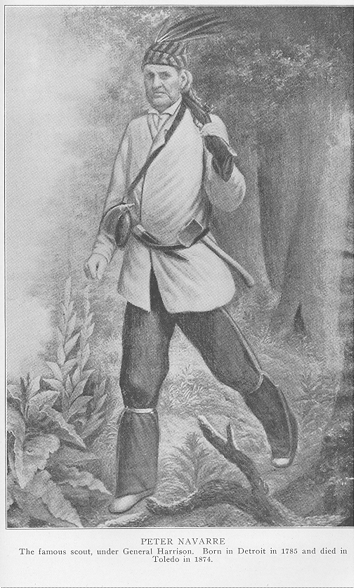
In cases where a road occupies a line between townships, one-half f such road is credited to each f the adjoining townships. The same system applies to roads on county lines, only one-half the mileage being given to the township in Lucas County along whose border the road runs. CHAPTER XVI. TOWNSHIPS AND VILLAGES TOWNSHIPS OF TWO CLASSES-EACH CLASS DEFINED-LUCAS COUNTY TOWNSHIPS- ADAMS-JERUSALEM - MONCLOVA-OREGON-AN INDIAN DEED– PROVIDENCE-RICHFIELD-SPENCER-SPRINGFIELD-SWANTON-SYLVANIA -- WASHINGTON-WATERVILLE-LEGEND OF ROCHE DE BOEUF- WAYNESFIELD- MAUMEE CITY-EARLY SETTLERS IN EACH TOWNSHIP -VILLAGES-RAILROADS- CHURCHES-POPULATION, ETC. Townships are of two classes—one based on the Government survey of the public domain, and the other the smallest unit of civil government in the United States. The former are sometimes called "Congressional townships," because the surveys were made in accordance with acts of Congress. They are, except in rare cases, six miles square, divided into thirty-six sections, each including one square mile. The exceptions occur where the survey is interrupted by a lake, river, or some other insurmountable obstacle, and where "fractional" townships are formed. Beginning at an east and west "base line," the first tier of townships is No. 1 north or No. 1 south, as the case may be. From a "prime meridian" running due north and south, the townships are divided into ranges, the first tier east f the meridian being Range No. 1 east and that on the opposite side Range No. 1 west. Consequently, every Congressional township is bounded on the north and south by township lines, and on the east and west by range lines. Civil townships are f unequal size and may be bounded by natural features, such as creeks, rivers, the summits. f ridges, etc., though in some localities the civil and Congressional townships are identical. In the New England States the township is more of a factor in local government than the county. At the annual town meeting, officers are elected for the ensuing years, taxes levied for town purposes and other important questions decided by vote of the entire population. Thomas Jefferson declared these town meetings to be the bulwark of American political In the South the civil township is practically unknown and the county is the important unit of local government. Where the township exists at all in many districts of the South, it is more as a matter f convenience in dividing the county into road and school districts than for purposes of local government. In several Southern States townships appear on the map, but no township officers are elected ; at least none with power to regulate local affairs. Throughout the Middle West these two systems are combined. The county authorities provide for the various courts, levy taxes for county purposes, and exer-cise a sort f general supervision over township affairs. The township officials are responsible for the establishment and maintenance of public schools, the repair of highways, etc. In most f the states f this section, the township authorities may - 229 - 230 - TOLEDO AND LUCAS COUNTY issue bonds for school or public improvement purposes, when such bond issues have been approved by popular vote, and to provide by taxation for the payment of interest and principal of the bonds. LUCAS COUNTY TOWNSHIPS The first township in what is now Lucas County was that of Port Lawrence, which was erected by the authorities of Michigan Territory on May 27, 1827, and attached to Monroe County. It embraced about one-half of the present County of Lucas and a large part of that strip which was claimed by both Michigan and Ohio (See chapter on The Boundary War). It passed out of existence on December 1, 1856, when a considerable portion of its territory was included within the city limits of Toledo and the remainder was annexed to Springfield Township. Manhattan Township, which was located at the mouth of the Maumee River, was established in June, 1840, but in 1874 its territory was annexed to the City of Toledo and Oregon Township. Twelve townships once in Lucas County were taken to form the County of Fulton in February, 1850. They were : Chesterfield, Clinton, Dover, Franklin, Fulton, German, Gorham, Pike, Royalton, Swan, Creek, Wing and York. This left ten civil townships in Lucas County. Since then three others have been erected, so that at the beginning of the year 1922 there were thirteen townships in the county, to wit : Adams, Jerusalem, Monclova, Oregon, Providence, Richfield, Spencer, Spring-field, Swanton, Sylvania, Washington, Waterville and Waynesfield. For convenience these townships are described in alphabetical order. ADAMS TOWNSHIP On December 3, 1856, the county commissioners of Lucas County adopted the following resolution : "That the territory heretofore belonging to the Township of Port Lawrence, and which was on the 1st day of December, A. D. 1856, set off from said Township of Port Lawrence and annexed to the Township of Springfield, together with sections Nos. 4, 5 and 6 in Town No. 3, United States Reserve ; the south fractional half of sections Nos. 31, 32, 33 and 34 in Town No. 9 south, Range 7 east ; the south fractional half f section No. 36, Town 9 south, Range 6 east ; sections Nos. 1, 2 and 12, the east half of sections Nos. 11, 14 and 23, and fractional sections 13 and 24, all in Town 2, United States Reserve ; fractional section No. 19, Town 3, United States Reserve ; all that part f private grants Nos. 575, 578, 579, 580 and 581, which was formerly in Springfield Township; also all that terri-tory which was formerly in Waynesfield Township lying northeast f private grant No. 581, extending to the center of the Maumee River ; thence down said river to the southwest corner f the City of Toledo, be established as the Township of Carey ; and that the first meeting for the election f officers for said new township be held at the home of Henry Driver on December 22, 1856." At the election as above provided for, J. P. Hill, Darius Mills and Peter H. Shaw were chosen trustees ; George W. Norton. clerk ; Elisha Mulford, treasurer. The township continued under the name of Carey until 1860, when it was changed to. Adams. It is centrally located, being bounded on the north by Sylvania and Washington townships ; on the east by the City of Toledo ; on the southeast by the TOLEDO AND LUCAS COUNTY - 231 Maumee River, which separates it from Wood County ; on the south by Waynesfield Township, and on the west by the townships of Monclova and Springfield. Swan Creek flows in an easterly direction through the central portion and the northern part is drained by tributaries of the Ottawa River. The soil is generally fertile and truck farming is an important occupation, the City of Toledo affording a ready market for the products. Early Settlers—In 1833 Orlando Bushnell located on eighty acres of land in the United States Reserve and he is credited with the distinction of being the first actual settler. At the time whisky was freely used at house-raisings, log-rollings, etc. Mr. Bushnell was conscientiously opposed to the use of intoxicating liquors. In inviting his neighbors to a "raising" he informed them that no whisky would be supplied. The result was, the settlers refused to assist him in erecting his cabin. Some friends in Vienna, sixteen miles away, hearing of his predicament, came over and raised his cabin for him. Soon after Mr. Bushnell came Bernard Cass, a half-brother of Gen. Lewis Cass' father, and his three sons—Charles M., Joseph G. and Samuel. Another settler in 1833 was John Patten, who located in the same neighborhood. He died suddenly soon after building his log house, aged seventy-three years. A son and a daughter —Harvey and Nancy Patten—continued to live on the homestead for more than fifty years after the death of their father. During the year 1834 several families were added to the population of the town-ship. Among them were Valentine Bargy, who bought eighty acres that had been entered by Augustus Whitney a year or two before. Michael Carney and Charles McTague, who purchased land from William M. Hudson. One of Mr. McTague's daughters (Ella) afterward taught for several years in the public schools of the township. John Egnew entered eighty acres in Section 12, but soon afterward sold it and removed to Swanton. Harvey Kellogg settled in the township in 1837. A story of Mr. Kellogg is told, which illustrates the condition of the township at the time it was organized in 1856. He was a delegate to a Sunday School convention at Maumee and when called upon for a report from his township, said : "We have no church, nor minister, nor lawyer, in Adams Township, but a doctor has lately moved in and the trustees have laid out ground for a cemetery." A laugh followed the statement that the trustees had taken steps for a cemetery so soon after the arrival of the physician and the newspapers mentioned the incident as "an excellent hit by a member from the rural districts." Mr. Kellogg taught school several terms after coming to Lucas County ; was postmaster at Hickory for several years ; was justice of the peace for fifteen years, and in 1877 was elected to the Legislature on the Greenback ticket. He was a native of Connecticut and for several years prior to his death was president f the Lucas County Sunday School Union. His wife was the first president of the Woman's Christian Association of the township, which was organized on May 12, 1882. Prior to the organization f this association, religious services had been held in school houses or at private residences. The association at once started a campaign for funds to build a church. A lot at the junction of the Dorr Street road and the Miami & Sylvania turnpike was donated by H. P. and V. Glenn, the sum of $2,000 was raised and in the fall of 1883 the Union Church was dedicated—free to all denominations. 232 - TOLEDO AND LUCAS COUNTY Other early settlers in Adams were : David Byrnes, John W. Clark, Cyrus Davis, John Halpin, David Kaley, Alonzo Lane, N. R. Locke, Peter Y. Mersereau, Samuel Nason, Jeremiah Reynolds and James P. Robinson. Of these pioneers, David Byrnes served as clerk and trustee ; John Halpin, trustee ; Alonzo Lane, clerk ; and James P. Robinson, justice f the peace. Jeremiah Reynolds also served as trustee and justice f the peace, holding the latter office at the time f his death in December, 1868. David Kaley came to Lucas County as a fifteen-year old boy in 1837 and worked for several years on the Miami & Erie Canal, where his brother-in-law had a contract. In 1849 he went to California, where he accumulated over ten thousand dollars in mining. Returning to Ohio in 1853, he bought a farm in Adams Township and there passed the remainder of his life. Towns and Villages—During the era of speculation that preceded the panic of 1837, towns were laid out all through the Middle West. Circulars—not always strictly truthful—setting forth the advantages of such towns were distributed through the Eastern States and often lots were purchased by credulous persons, hoping to realize large profits from their investment. Most of these towns proved to be of the "mushroom" variety and some of them never got beyond the paper stage. Three of these towns were platted within the present limits of Adams Township. On June 11, 1836, Samuel Divine, county surveyor, laid out the Town of Vinton for Amos Atkins and Daniel Hubbell. It was located in Section 13, Township 2, on the south side of Swan Creek and adjoining the French grant. The plat showed fifty-four lots and ten streets, but Vinton never came to anything as a town. The Town of Marengo was located in what is now Adams Township, "on the left bank of the river at the foot of the rocky bar, and therefore at the virtual head of navigation." It was laid out in June, 1836, and was thus described soon afterward by an enthusiastic writer : "About ten miles from the mouth of the river lies the military reserve. This is a plat of ground extending up and down the river about a mile and a quarter, and lying on both sides. The United States Government would never consent to part with this portion of the public domain until this spring. It was advertised and sold at auction at Bucyrus on the fourth of April last and immense sums of money were on the spot for the purchase. An arrangement was effected by nineteen gentlemen from different parts of the country and the whole was bid off for their benefit and placed in the hands of trustees. The proprietors selected five directors and resolved to lay out a town, which they have named 'Marengo' ; and it is expected that the sales will be opened by public auction and from 300 to 500 lots disposed of in that way. It can scarcely admit of a doubt, that Marengo will in a few years become a large and densely populated city. There, it is believed, the Wabash Canal will terminate, as no good reason can be discovered for its extension farther down the river. All the rich commerce of Western Ohio, the Wabash country, a large portion of Illinois, besides much on the Ohio River, must be poured out here, with all the surplus products of this proverbially luxuriant soil, seeking a northern market. Good building stone can easily be procured, as the rock bar extends into the country on each side of the river. And in conclusion, ermit me to say, that I hesitate not to predict that at no distant day Marengo will be the largest town in Western Ohio." The nineteen men above referred to were : James Q. Adams, Norman C. Bald- TOLEDO AND LUCAS COUNTY - 233 win, Henry Bennett, S. B. Campbell, Elnathan Cory, Jedediah D. Cummings, David W. Deshler, Elias H. Haines, David Ladd, Joseph H. Larwell, John E. Lyon, Robert T. Lytle, Daniel B. Miller, William Neil, Christ Neiswanger, John C. Spink, Needham H. Stewart, Jesse Stone and Dwight Woodbury. In the organization of the Marengo Town Company, Norman C. Baldwin, Elnathan Cory, William Neil and John C. Spink were elected trustees, and Norman C. Baldwin, Joseph H. Larwell and Dwight Moody, directors. The plat was made by Hiram Davis, surveyor of Wood County, but the City of Marengo failed to come up to the anticipations of its founders, who had paid $40,000 for the 443 acres f land. The company's affairs were wound up by order f the court in August, 1838. About this time a company known as the "East Marengo Company" was organized by Charles Borland, David Higgins, Nathan Jenkins, John Patterson, William P. Reznor, H. O. Sheldon and Ezra M. Stone. On June 14, 1836, this company purchased from Rev. James Gilruth and his wife, f Ann Arbor, Michi-gan, 363 acres f land in Sections 17 and 20, Township 3, for which was paid $36,250. Higgins, Jenkins and Reznor were elected trustees and the Town f East Marengo was laid out, but like other boom towns f that period, it disappointed the hopes of its projectors. Other early villages were Central Grove, Norwood and Toledo Heights. Part of the territory included in these plats is now within the City of Toledo. The only village shown upon present day maps is Richards, located near the northwest corner of the township. Although several steam railroads pass through Adams Township, the inhabitants depend chiefly upon the electric lines for transportation. The Toledo & Indiana Electric Railroad runs through the northern part, and the Ohio Electric Railway through the southern part, almost parallel to the old Miami & Erie Canal. Adams has twenty-eight miles of improved highway, four public school buildings, and in 1920 reported a population of 4,735, a gain of 2,100 during the preceding decade. JERUSALEM TOWNSHIP This is the youngest township in Lucas County. It was created by an act of the Ohio Legislature, approved on March 10, 1893, which act provided : "That the Township of Oregon, in the County of Lucas and State of Ohio, be divided as follows: All that part of said township lying west of a line running north and south, commencing on the county line between the counties of Ottawa and Lucas, eighty rods west f the southeast corner of Section seventeen (17), Town ten (10) south, of Range nine (9) east and running thence north through the center of the east half of sections seventeen (17), eight (8) and five (5), town and range as before described thence through the center of the east half of sections thirty-two (32), twenty-nine (29) and twenty (20), Town nine (9) south, of Range nine (9) east, shall be known as Oregon Township. All that part of said township lying east f said line shall be known as Jerusalem. Provided, that so much of the election precincts as remain in Oregon shall be and remain the same as they now are and all in said Township of Jerusalem shall be one precinct." The act further provided that the trustees of Oregon Township should hold an election in the new Township of Jerusalem on the first Monday in April, 1893. As this township was for many years a part of Oregon, its early history will be found in connection with that township further on in this chapter. 234 - TOLEDO AND LUCAS COUNTY Jerusalem is the most eastern township of the county. On the north it is bounded by the Maumee Bay ; on the east by Lake Erie ; on the south by Ottawa County, and on the west by Oregon Township. It is situated in what is called the "Black Swamp" district. The surface slopes gently toward the lake and the soil is unsurpassed in fertility. Originally it was heavily timbered and furnished large supplies f lumber and cooperage material. Among those who entered land at an early date was Margaret Bailey, who became the owner of nearly five thousand acres as early as 1839. During the decade from 1840 to 1850 she sold parcels of this land to John B. Arnold, Sylvester Brown, James Cahoo, Coonrod (or Conrad) Dusernois, Joseph Hildebrand, Milton Huntley, Jacob Keiser, Enoch Kent, Adolph Letz, Andrew Metzger, Victor Pinney, Philo B. Scott, William Van Orden, Edward Woodruff and John Yohn. Most f these purchasers were nonresidents, but a few of them settled upon their lands and were the pioneers of the township. Jerusalem is the only township in the county without a railroad, but two lines of improved highway connect it with the City of Toledo. It has no village of importance and only three small hamlets—Jamestown, in the northwestern part, on the Maumee Bay ; Shepardsville (post office name Bono), in the southeastern part ; and Yondota, about two miles west of Shepardsville. The township has eight public schools and in 1920 reported a population of 1,297. MONCLOVA TOWNSHIP Monclova is situated in the southwestern part of the county. On the north it is bounded by the townships of Spencer and Springfield ; on the east by Adams and Waynesfield ; on the southeast by the Maumee River, which separates it from Wood County ; on the south by the Township of Waterville, and on the west by Waterville and Swanton. On March 7, 1853, a petition signed by a number of citizens living in Springfield, Swanton and Waynesfield townships was presented to the county commissioners asking for the formation of a new township, to be called Monclova. A remonstrance was also filed with the commissioners. Both sides were heard on the 9th and the board took the matter under advisement until the 14th, when the petition was granted and Monclova Township came into existence. The commissioners ordered an election for township officers to be held on the first Monday in April. The records of the township prior to 1878 have been lost, but from other sources it is learned that Warren B. Gunn was the first clerk ; Adam Black, the first treasurer ; and J. O. Allen the first chairman of the board of education. Settlement—Among the early settlers of Lucas County were Samuel and William Ewing, who, a few years before the beginning of the War f 1812, built a saw-mill on Swan Creek, where the village of Monclova now stands. Anthony Ewing, a son of Samuel, is said to have been the first white child born in the township. He was born in 1808 and was about four years old when Uncle Peter Manor brought the news to the settlement that the United States had declared war against Great Britain. During the war many of the settlers in the lower Maumee Valley left their homes for fear of being massacred by Indians. In 1815 Ephraim H. and Thomas Leaming, brothers. came from New York and settled in Perrysburg. Two years later, when the United States offered for sale the lands of the military reserve, they bought a tract on Swan Creek, rebuilt the old Ewing mill and made a large part f the lumber used in building the early residences TOLEDO AND LUCAS COUNTY - 235 in Maumee City, the lumber being hauled from the mill by ox teams. When the Leamings came from New York, Ephraim was accompanied by his wife and their three children—Ephraim, Maria and Thomas H. Ephraim was drowned in the Maumee River at Perrysburg, a short time before the family removed to Swan Creek. Maria became the wife of Anson Reed and passed a long and useful life in the township. Thomas H. married Huldah, daughter of Charles Merrill, and their son, W. G. Leaming, was elected clerk of Monclova Township in 1887. Thomas H. Leaming was for several years president of the Maumee Valley Pioneer Association. He died at Monclova on June 21, 1885, and at the time was the oldest male inhabitant of the township. Another early settler was Daniel Murray, who located on Dry Creek, in the northwestern part of the township, a few months before the coming of the Leamings. He sold out and left Lucas County in 1824 and there were few additions to the population from that time until in the early '30s. In 1831 Hezekiah Hubbell located on the military reserve, where the Village of Monclova is now situated. He and O. H. Beatty laid out this village in May, 1836. Mr. Hubbell married Anna Steel and to this union were born five children. A son, C. L. Hubbell, afterward became prominent in township affairs. He was one f the early merchants of Monclova, served as postmaster there, and in 1883 was elected one of the township trustees. Other settlers, who located in the township prior to 1840, were : Conrad Coder, George Allen, Adam Black, John Strayer, Henry Heffelbower, Conrad Noble, Peter P. Bateman and William Weible. W. W. Coder, a son of Conrad, held the office of township clerk for several terms and was for more than twenty years a justice of the peace. Another son, Jeremiah, was three times elected township trustee. Villages—As already stated, the Village of Monclova was platted in 1836. A post office was established there in 1854, with Benjamin F. Barnes as the first post-master. It is located near the center of the township. C. L. Hubbell built the first store soon after the town was started and was for many years engaged in mer-chandising. Aaron Trapp was another early merchant. A blacksmith and wagon shop was established there before the township was organized. C. L. Hubbell also built and opened the first hotel. The first schoolhouse in the township was built here in 1838. Two United Brethren congregations were organized in the township by ministers named Bright and Needles. The Methodists and Disciples of Christ held services in the schoolhouse for several years, but never erected houses of worship. When the Wabash Railroad was built through the township it missed the village about a mile and a station called Monclova was established south of the main village. Monclova is a trading center for a large agricultural district. The only other village in the township is Presque Isle, in the southern part. It grew up after the building of the Toledo, St. Louis & Western Railroad and took its name from the bluff on the Maumee River near by. It is a trading and shipping point for the farmers in that locality. Monclova Township reported a population of 991 in 1920. It has about twenty-five miles of improved highway ; is well drained by Dry and Swan creeks ; has a fertile soil and several of the best farms in the county are located in this township. At the time of the Civil war Monclova furnished 111 volunteers to the Union army. Transportation is furnished by the Clover Leaf, Wabash and Ohio Electric railways. 236 - TOLEDO AND LUCAS COUNTY OREGON TOWNSHIP On June 4, 1837, Isaac Street and others presented a petition to the Commissioners of Lucas County asking for the erection of a new township "to include all the territory on the east and south side of the Maumee River, to be known by the name of Oregon." The territory comprising the township was originally included in the townships of Manhattan and Port Lawrence. At the time the petition was presented the board of county commissioners was composed of Samuel Bartlett, William P. Daniels and Robert Gower. They granted the petition and ordered an election for township officers to be held at the house of Isaac Street on the 4th of July. The township was not fully organized, however, until the 10th of September following its erection. Waggoner's "History of Toledo" says: "The name Oregon was suggested by Pierre M. Irving, a nephew of Washington Irving, who lived in Toledo from the spring of 1836 to the summer of 1838; and it was probably inspired by his uncle's 'Astoria,' which had then awakened great interest in John Jacob Astor's trading lands, in which is now Oregon Township. Thus the name is associated with a very pleasant romance. Mr. Irving was here to look after his uncle's interest in Toledo. He left with his wife for a temporary visit to New York in the summer of 1838, but never returned, dying in that city in February, 1876." The early township records have been lost and a complete list of the first officers cannot be given. Leonard Whitmore was elected clerk in 1837 and held the office for four years, when he was succeeded by Gabriel Crane. Several changes have been made in the original boundaries. On December 2, 1856, that portion within the Toledo city limits was taken from Oregon and annexed to Port Lawrence. By the ordinance of July 2, 1872, a considerable portion of the township was annexed to the city. When Manhattan Township was abolished on November 2, 1874, that part of it "south of the center of the channel of the Maumee River" was annexed to the Township of Oregon. By the act of March 19, 1893, the eastern part was cut off to form Jerusalem Township. At the beginning of the year 1922 the boundaries of Oregon were as follows: On the north by the Maumee Bay ; on the east by Jerusalem Township ; on the south by Wood County, and on the west by the City f Toledo. Early Settlers—As early as 1808 the six Navarre brothers—Alexis, Antoine, Francis, Jacques, Peter and Robert—were living with the Ottawa Indians in their village at the mouth f the Maumee River. In the treaty concluded with these Indians at Maumee in February, 1833, the Navarres were given a reservation of 800 acres on account of the long friendship that had existed between them and the Ottawa nation. Prior to the negotiations of that treaty (See Chapter III) much of the land in the township was not open to white settlement, though a few individuals had located there. Joseph Prentice, who was interested in the original Port Lawrence Company and came to that town in 1817, crossed the Maumee in 1825 and selected a tract of land in what is now Oregon Township. His son Frederick, then about three years old, grew up among the Indians, learned their language and late' became an interpreter for Indian agents and traders. Others who came before the treaty of 1833 were : Luther Whitmore, in 1829 ; Robert Gardner, in 1830 ; Hiram Brown, Gabriel Crane, Philander Fox and a few others, in 1831. Mr. Whitmore came to Ohio from Massachusetts in the spring of TOLEDO AND LUCAS COUNTY - 237 1825, bringing his wife and six children. He first settled in Wood County, opposite the Turkeyfoot Rock. His son, Leonard, was the first clerk of Oregon Township. A daughter, Mary Ann, became the wife f Gabriel Crane. After 1833 the settle-ment was more rapid. Among the pioneers who came before 1840 were : John Consaul, Lawson Hicks, Elias Fassett, Charles V. Jennison, Asa W. Maddocks, Hiram Vinal and Elijah J. Woodruff. In 1836 the first sawmill in the township was built by Charles V. Jennison. It was located on the river bank, on the site of the old Town f Oregon, was operated by steam power, and furnished the flooring for the first bridge across the Maumee at Toledo. The following year he built the schooner "Ottawa," which sailed on the Great Lakes for many years. Mr. Jennison was a son of Victor Jennison, who settled at Perrysburg in 1818. The second sawmill in the township was built in 1849 by Frederick Prentice, already mentioned. It was a steam mill, located a short distance below the present Cherry Street bridge, and was operated by Mr. Prentice for a number of years. During that time he purchased several large tracts f land and after taking off the timber sold the land to settlers. He finally removed to New York City. AN INDIAN DEED Shortly after the treaty f 1833, the Indians who had been granted personal reservations received authority to sell them to the white men. Several of the chiefs took advantage of this permission to dispose f their holdings. As the Indians were the wards of the United States, great care had to be exercised in dealing with them, in the execution of deeds, etc., as will be seen by the following copy of one of these documents : "State of Ohio, Wood County, ss : "Know all men by these presents : That I, Au-to-kee, a chief of the Ottawa tribe of Indians, and son of Tush-que-gan, in consideration of the sum of $1,000, to me in hand paid by James W. Knaggs, of the County of Wood and State of Ohio, do hereby give, grant and convey to said James W. Knaggs, and to his heirs and assigns forever, all that certain tract or parcel of land contained in the west half f my tract, lying in said County of Wood at the mouth of the Maumee River (south side) adjoining Presque Isle, which I lately granted to Robert A. Forsyth and George B. Knaggs, and bounded by said Presque Isle on the west ; on the north by Lake Erie ; on the east by the east half of said tract ; and on the south by land granted to Alexis Navarre by the United States at the treaty with said tribe of Indians in February, 1833, at which treaty this said tract was granted to me, the west half of which, containing 125 acres, I hereby grant to James W. Knaggs. And I further covenant and promise with and to the said James W. Knaggs, the above premises to him, his heirs and assigns forever, to warrant and defend. "In witness wheref, I have hereunto set my hand and seal, this 4th day f August, in the year of our Lord, 1835. "Au-To-KEE (L. S.)" This deed was "Signed, sealed and delivered in the presence of H. Conant and Jacques Navarre," the latter acting as interpreter in the transaction, and bore the following acknowledgment : 238 - TOLEDO AND LUCAS COUNTY "State of Ohio, ss : Wood County, "On the 4th day of August, in the year of our Lord 1835, personally came Au-to-kee, Indian chief of the Ottawa tribes, the maker of the within deed ; and the purport and meaning f the within deed being fully explained to him, he acknowledged that he signed and sealed the same and was content and satisfied with the consideration therefor ; and that he executed said deed and makes the above acknowledgment without any circumvention or undue influence or persuasion of the grantee, or of any other person whomsoever. "Before me, Horatio Conant, a Justice f the Peace in and for said county ; and I further certify, that I was present at the execution f the within deed, and counted out and delivered to the said Au-to-kee the consideration mentioned in said deed, $1,000. Witness my hand and seal, the day and year above written. "H. CONANT, "Justice of the Peace." On the same day, and by means of a similar deed, Au-to-kee conveyed to Robert A. Forsyth and George B. Knaggs the property known as Presque Isle, at the mouth of the Maumee River, which included the remainder of his reservation. The consideration in this case was also $1,000. The first school in Oregon Township was taught by Elizur Stevens in 1834 (See chapter on Educational Development). The first church congregation was organized by the Baptists in 1863. It is now the Memorial Baptist Church in East Toledo. Booth, a small station on the Wheeling & Lake Erie Railroad, and Momeneetown, a small hamlet in the east central part, are the only villages. The Northwestern Ohio Electric Railway runs through the southern part of the township, connecting it with the City of Toledo. Oregon has seven public schools, nearly forty miles of improved highway, and reported a population of 3,500 in 1920, an increase of 932 over the census of 1910. PROVIDENCE TOWNSHIP Situated at the southwest corner of Lucas County is the Township of Providence. It is bounded on the north by Swanton and Waterville townships ; on the east by Waterville ; on the south by the Maumee River, which separates it from Wood County, and on the west by Fulton and Henry counties. The south fork of Swan Creek flows in a northeasterly direction through the central part of the town-ship and there are a few smaller streams. It was established by order f the county commissioners on June 6, 1836, and an election was ordered to be held at the house f Peter Manor on the last Saturday in July. At that election the following township officers were chosen : Benjamin Atkinson, Xenophon Mead and Drake Taylor, trustees ; William Ewing, clerk ; Norman Mead, treasurer ; Hiram Tuboo and John Feagles, poormasters ; John Diefendeiffer and George Hale, fence viewers ; Joseph Hartwell and Peter Manor, constables. The clerk and treasurer failed to qualify and the trustees appointed Xenophon Mead and Drake Taylor to act as clerk and treasurer, respectively, until the next election. The highest number f votes cast for any candidate at this first township election was fifteen, but at the presidential election the following November just twice that number were cast. The names of these voters were : Hugh Arbuckle, Benjamin Atkinson, William L. Bellinger, John
TOLEDO AND LUCAS COUNTY - 239 Berlin, David Blanchard, Samuel Cable, Oral Colyer, Andrew Elsey, William Ewing, John Feagles, Henry Galloway, John Galloway, Lovett Gibson, John Gass, George Hale, John Hartwell, Elam Locke, Charles McKarns, Francis Manor, Peter Manor, Peter Manor, Jr., Aaron B. Mead, Xenophon Mead, Samuel Miner, Philip C. Mosher, William Pettinger, John Stout, Francis Yager, John J. Yager and Peter Yager. The first actual settler within the limits of Providence Township was Peter Manor, a sketch of whom has been given in the preceding chapter. In 1816 he settled upon the laid given him by his Indian father, Tondagamie (the Dog), which land was confirmed to him by the United States in a deed dated November 27, 1827, signed by John Quincy Adams, then President, and Henry Clay, Secretary of State. This deed remained in the possession f his descendants for many years. His son, Francis Manor, was elected clerk f the township in 1845, and another son, John J. Manor, was prosecuting attorney f Lucas County from 1851 to 1857. Most of the voters named in the above list came to the township prior to the year 1830 and were the pioneers. William Ewing was elected the first justice of the peace in December, 1836. In 1828 these settlers built a log schoolhouse on the Peter Manor reserve. and Martha McKarns was the first teacher. Until 1835 the nearest post office was at Maumee. The postmaster there appointed carriers to take the mail to the Peter Manor settlement. This was probably the first rural mail delivery in the United States. One of these carriers, John Omen, made his weekly trips for several years through a district inhabited almost exclusively by Indians, but was never molested. Providence Village—In 1835 Peter Manor laid out the village, the plat showing eighty lots and five streets—Main, Center, Ford, Spring and West. A post office was soon afterward established, with John Berlin as the first postmaster. Aaron B. Mead erected a store building and brought the first stock of goods into the town-ship. He was active in township affairs, though the only office he ever held was that of trustee, to which he was elected in 1841. Other early merchants were J. B. Abele and Neptune Nearing, both of whom were in business before the close f the year 1835. A man named Phillips built a hotel, which was opened either late in 1835 or early in 1836. As Providence lay directly in the path of western emigration, it became a stopping place for many travelers. By 1840 there were five hotels in operation and warehouses had been built to accommodate the traffic on the Maumee River. When the village was about two years old, work was commenced on the Wabash & Erie Canal and Providence experienced its first real boom. Incidentally it acquired a rather bad reputation. Liquor was sold there and the laborers on the canal, as well as some of the permanent inhabitants, would engage in drunken carousals, which frequently would wind up with a free-for-all fight. In 1846 a large part of the village was destroyed by fire and much f the principal business portion was never rebuilt. After the cholera epidemic f 1852, Providence practically disappeared from the map. Francis Manor and Elias Oberly were for a number f years the only residents. Neapolis— The Village of Neapolis, in the northwestern part of the township, on the Wabash Railroad, was laid out in 1872 by J. O. Arnold, William A. Barnett and Jackson Jordan, all of Dayton, Ohio, who owned the land. The railroad company recognized it as a regular station and a post office was established soon after 240 - TOLEDO AND LUCAS COUNTY the village was platted. As the post office at Providence had been discontinued, the Neapolis post office was the only one in the township. T. B. Meredith was the first postmaster. Neapolis is a trading center and shipping point for a large district in the western part of the county. The only other village in Providence Township is Bailey, a station on the Toledo, St. Louis & Western Railroad, near the southeast corner. No regular plat of the village was ever filed, though it is a business and rallying point for the people in that part f the township. Churches—The first church in the township was St. Patrick's Catholic Church. In January, 1845, Peter Manor deeded to Bishop Purcell the site and the same year a house of worship was erected. Rev. John Maloney was the first priest, and remained in charge of the parish until 1863. Forty-five years after that church building was erected it was said to be the third oldest Catholic Church in the Cleveland Diocese. It does not appear in the "Year Book" of the Toledo Diocese for 1921. Prior to the establishment of St. Patrick's Church, services had been held by ministers of various denominations in the schoolhouses or private residences. In 1866 the first Protestant Church was organized as a Union Church and a building was erected near the schoolhouse in District No. 4. It was burned about ten years later. Salem Church, near the Waterville Township line, was erected in 1868, and in 1874 Rev. O. J. Britton organized the Christian Church at Neapolis. In 1882 the Mount Pleasant Church was erected by the Protestant Methodists in the northern part f the township. St. Malachi's German Reformed Church was built in 1877, but for ten years had no regular pastor. According to the census for 1920, Providence Township then had a population of 1,147, a decrease f 70 during the preceding ten years. The Wabash Railroad crosses the northern part and the Toledo, St. Louis & Western runs along the southern border, crossing the Maumee River about half a mile below the old Village of Providence. RICHFIELD TOWNSHIP On December 2, 1839, the county commissioners ordered certain territory in the northwest corner pf Lucas County to be erected into a township to be called Richfield. The name was adopted on account of the nature of the soil. As originally created Richfield included part of the present Township of Spencer. After the latter was created the boundaries of Richfield were left as follows : On the north by Lenawee County, Michigan ; on the east by Sylvania Township ; on the south by Spencer Township, and on the west by Fulton County. Its area is about twenty-two square miles. The surface is gently rolling and drained by two branches f the Ten-mile Creek. At the time the township was erected, the county commissioners ordered an election to be held at the house f Willard S. Fuller on the first Monday in April, 1840. At that time Benjamin Fairchild, Oliver Root and Jacob Wolfinger were elected trustees ; Willard S. Fuller, clerk ; Aaron H. Cole, treasurer ; Eli Munson and Pliny Sanderson, overseers f the poor ; John All, David Hendrickson and William Taylor, fence viewers ; Charles Courson, Araunah B. Lathrop and Wil-liam Tunison, supervisors of highways ; Jacob All, David Hendrickson and Araunah B. Lathrop, constables. TOLEDO AND LUCAS COUNTY - 241 Early Settlement—In May, 1834, Jacob Wolfinger came from Bucks County, Pennsylvania, and built a log cabin near the southeast corner of the present township. His son, Jacob M., was born on November 6, 1834, and was the first white child born in the township. About the time Mr. Wolfinger built his cabin, Lucian B. Lathrop settled on the north fork f Ten-mile Creek, about a mile east of the present village of Berkey. Some time that summer David Hendrickson came from New York and settled near the center of the township, where he lived for more than fifty years. Araunah B. and Pliny Lathrop also came in 1834 and these men are credited with being the first settlers in the township. Later in the year they were joined by Isaac Washburn, from Vermont. In 1837 Jacob Wolfinger planted the first orchard, setting out a number f apple and peach trees. He lived to enjoy the fruits of this orchard for twenty years, his death occurring on December 13, 1857. Lucian B. Lathfop built the first frame house in 1837. By this time several families had settled in the northern part of the township and a schoolhouse was built near the present village of Berkey. That winter Francis Smith taught the first school, receiving twenty dollars a month, out of which he paid his board. The term lasted only two months. In 1838 the first frame house in the township was built by Pliny Lathrop. Villages - In 1835 a post office called Riga was established and Lucian B. Lathrop was appointed postmaster. About the beginning of the Civil war R. K. Berkeybile was appointed postmaster. He was commonly known as "Berkey," the post office became known as "Berkey's Corners," and in 1865 the name of the post office was changed to Berkey. A. D. Sanderson was the first merchant, Dr. M. M. Mason the first physician, locating there in 1840, and was the first resident physician in the township. Jacob B. Gillan established the first black-' smith shop. Berkey is on the line of the Toledo & Western Electric Railway and in 1920 reported a population of 201. The first religious organization was known as "Farley's Class," located at Berkey. James Farley, the leader, was a native of County Tyrone, Ireland, who settled in the township in 1837. After a few years the class was organized into what is now the Berkey Methodist Episcopal Church, with Rev. James Evans as pastor. Richfield Center dates its beginning from 1870, when Henry King opened the first store in the township there. The post office was established in July, 1873, with William H. Williams as postmaster. George Darton and a man named Hoover started blacksmith and wagon repair shops, but the latter soon afterward engaged in the grocery business. John Haas opened the first harness and shoe shop. Dr. E. Tompkins located there in 1877. Rev. A H. Cole, a Baptist minister, held the first religious services and the Richfield Baptist Church was organized in 1861, nine years before Mr. King opened his store. A church edifice was erected in 1868 at a cost f $3,000. A Christian Church was organized in the township in 1855 by Rev. Stillman Post. A frame house of worship was erected and used until 1870, when a larger one was built in the Lathrop neighborhood, near the northwest corner f the township, at a cost f $2,500. Richfield is an agricultural township. The only railroad is the Toledo & Western Electric line, which runs through the northern portion. In 1920 the population was 1,036. 242 - TOLEDO AND LUCAS COUNTY SPENCER TOWNSHIP Spencer is one f the western tier of townships. It is bounded on the north by Richfield and Sylvania townships ; on the east by Springfield township; on the south by the townships f Springfield, Monclova and Swanton, and on the west by Fulton County. Its area is twenty-three square miles, nearly all of which is fertile and capable of cultivation. The township was set off from Richfield and Swanton in March, 1845, by the county commissioners, who ordered an election to be held at the house of Abraham Johnson on the first Monday in April. The officers elected at that time were as follows : William Brown, Samuel Cole-man and Eli Munson, trustees ; Aaron H. Cole, clerk ; Theron Hamilton, treasurer ; Darius Wyatt, assessor ; John All and Aaron Whitacre, overseers of the poor ; Benjamin Fairchild and William Norris, supervisors of highways ; Charles Courson and William Taylor, constables. No justices f the peace were chosen at the first township election, but on April 6, 1846, Benjamin Fairchild and William Brown were elected, the former to hold office until 1848 and the latter until 1855. Mr. Fairchild had previously served as justice f the peace in Swanton Township. Pioneers—The greater part of the township lies between the Fulton and Harris lines, and was therefore in the strip claimed by both Ohio and Michigan. The early land entries were made at the Monroe land office. Among those who came into the township between the years 1832 and 1835 were : John All, William Brown, Aaron H. Cole, Samuel Coleman, Charles Courson, Benjamin Fairchild, Abraham Johnson, Eli Munson, Patrick Parks, Gideon Rice and William Taylor, all of whom were living within the limits of the present township when the boundary dispute was settled in 1836. The names of several of these early settlers appear in the list of the first township officers. Some idea of pioneer life may be gained from the following statement, made by one of the early settlers of Spencer Township several years after it was formed : "When we came here it was all woods. There were more Indians than white people. We could see an Indian every day, or a squad f them with their squaws and papooses, but a white man or a white woman was a rare sight. Our nearest neighbors lived from three to four miles off, and there were no roads, only trails through the woods. Maumee was the nearest point where we could get the needed supplies, and as there were no roads even 'chopped out,' we had to 'pack' supplies to our cabins The first mill I remember f going to to get corn ground was a concern run by oxen. They walked 'round hitched to a pole or shaft. It was gotten up by a man named Berry, near what is now Ai, in Fulton County. It was not much of a mill—a sort f coarse corn cracker. Sometimes we went to Blissfield, Michigan, to mill and afterwards to Waterville. After the mill at the latter place was built, it was the best and the nearest, but it often took from one to three days to get a grist, the settlers coming from all around and waiting their turn. I have slept there all night on the bags, and at one time two nights, waiting for my grist. The usual mode f going to mill was with oxen, when one was well enough off to have such ; but most f the settlers were poor and had to put up with great hardships. Sometimes men would go out and work at some odd job for a bushel or two or corn, take it on their backs to mill, wait for it to be ground, and return with the proceeds to their lonely cabins and anxiously TOLEDO AND LUCAS COUNTY - 243 waiting families, ften at night through the dark forests. Money was very scarce and prices high. The land was wet and chills and fever prevailed. The country is now ditched and made healthy compared with what it was. Most of the pioneers were hardy and strong men and could stand most anything." Late in the year 1836 the settlers in the northwestern part of the township got together and built a log schoolhouse on the farm of Eli Munson. It had a puncheon floor, the clapboards of the roof were held in place by poles, and the puncheon door was hung on wooden hinges. Chester Holloway was the first teacher. The first church was that of the Immaculate Conception, which was the result of services conducted by Father Armedeus Rappe, beginning in 1838 and continuing for several years. A log church was built in 1851 and was replaced by a frame structure in 1864. This building was burned in June, 1875, and a brick edifice was erected at a cost of $12,000. It was seriously damaged by a tornado in March, 1880, but was rebuilt and when completed was considered the finest country church in the county. Rev. Aaron H. Cole, a Baptist minister, began holding services at an early date in the schoolhouse and in private residences. The result of his labors was the organization of a Baptist Church, though no house of worship was erected until 1873. Mr. Cole also organized the Baptist Church at Richfield Center. He was the first clerk of Spencer Township, married Lydia Rappleyee in March, 1835, in Seneca County, New York, and soon afterward came to Lucas County. In 1866 he removed to Adrian, Michigan, and died there in October of the following year. A German Reformed Church was organized in 1852 and a church building was erected in 1864. The German Baptist Church, organized by Rev. Sabastian Site (or Seitz), built a neat frame church in 1878. There are no important villages in the township. Barnes' Corners, a little west of the center, is a trading point for the neighboring farmers, and the same may be said f Frankfort, in the northwestern part. Garden is a small station on the New York Central Railroad and the Toledo & Indiana Electric Railway, and Raab Corners, on the line between Spencer and Richfield townships, is another neighborhood center. The population of Spencer in 1920 was 817, being the smallest f any township in the county. SPRINGFIELD TOWNSHIP The following resolution, adopted by the county commissioners on June 20, 1836, tells the story of Springfield Township's beginning : "Resolved, by the board, that a new civil township be erected, to be comprehended within the following boundaries, to wit : Commencing on the south line of Township No. 2, in the Twelve Mile Square Reserve, between Sections 32 and 33 ; thence north, on the section line, to the north line of said sections ; thence east, on said section line, to the west line of Section 27; thence north, on said west line, to the north line of said Section 27; thence east, on said north line, to the west line of Section 23; thence north to the north line of said Section 23; thence east on the said north line to the west line of Section 13; thence north to the Fulton line; thence east 244 - TOLEDO AND LUCAS COUNTY on said Fulton line to Port Lawrence Township ; thence bounded on the east by Port Lawrence Township, on the north by the north line of said Township No. 2, and west by the west line f said Township No. 2, until it strikes the Fulton line from the north; thence by the east line of Townships Nos. 7 and 8, in Range 9, until it strikes the south line of Township No. 2 ; thence on the south by the south line of Township No. 2, to the place of beginning; and the said township shall be known under and by the name f Springfield." Several changes have been made in the original boundaries as thus described. On June 5, 1839, five sections were taken from Waynesfield Township and added to Springfield. On March 14, 1853, that portion of Waynesfield included in the north half f river tracts Nos. 575, 578, 579, 580 and 581 was added to Springfield, and at the same time the southern part of Springfield was cut off to aid in forming the Township of Monclova. When Adams Township was erected on December 3; 1856, the north half of the river tracts above mentioned, with some other territory, was taken from Springfield and added to the new township. This reduced Springfield to its present dimensions. It is bounded on the north by Spencer, Sylvania and Adams townships ; on the east by Adams ; on the south by Monclova, and on the west by Monclova and Spencer. At the time the resolution erecting the township was adopted, the commissioners issued an order for an election to be held at the house of William Ford on the second Tuesday in October following. Accordingly, the election was held on October 8, 1836, and resulted as follows : John Birchfield, James Egnew and Thomas Wood, trustees ; Peter Holloway, clerk ; John Wiltse, treasurer ; John Birchfield and John Spencer, justices of the peace ; William Ford, constable. Early Settlers—Dennis Sage, Who located in the township in 1829, is credited with being the first settler. He afterward served five terms as township treasurer. He married Mrs. Sarah Holloway, widow of Herbert Holloway, by whom he had four children. One f the sons, Thomas W. Sage, was afterward in the agricultural implement business at Holland. Dennis Sage died in 1887, aged ninety-three years. Chloe Lees and her two sons—Edmund and Simeon P.—settled in the township in 1830. Between that time and 1834 a number of families settled in the township. Among them were Bingham D. and Lorenzo Abbott, Jonathan Barlow, Willard Barnes, William Beals, William Berry, John Birchfield, John Cummings, James Dean, Ellison DeMott, John, Joseph, Samuel and Selah Divine, Jacob Falk, Patrick Flynn, James R. and William Ford, Linas Frost, Jacob and John Gnagy, Peter Holloway, Jeremiah Kimball, James S. Kitchell, Philander Noble, David Purdon, Herrick A. Rew, Isaac Silvers, John Strayer, David Trumbull, Abraham and John Walter. In 1834 John Gnagy built a sawmill on Wolf Creek—the first in the township--and about two years later John Walter built one on Swan Creek, near the southeast corner. The Gnagy mill also had a small set of buhrs for grinding corn. Thomas Wood came with his family from New York in 1835 and entered land in the township. His son, Harrison Wood, served in Company A, Fourteenth Ohio Infantry, until wounded at Tullahoma, Tennessee. After the. war he engaged in business as a merchant at Holland. In 1872 he was elected township clerk. A brother, Perry Wood, served two terms as justice of the peace. Villages—Holland, near the center of the township, is the only village of TOLEDO AND LUCAS COUNTY - 245 importance. It is a station on the New York Central Railroad and the Toledo & Indiana Electric Railway. That part of the village north f the railroad was laid out by Robert Clark and the plat was filed on March 14, 1863. South of the railroad the village includes what are known as "Hall's first and second sub-divisions." The first mails were carried by stage and there was a post office about three miles west of the present Village of Holland, at the tavern of James Dean, on the old Toledo Plank Road. After Holland was laid out the post office was removed to that place and Thomas Dunn was appointed postmaster. Holland has several general stores, a post office, etc., and is connected with Toledo and the surrounding country by telephone. Crissy is a small station on the two railroads, about three miles west of Holland. It has a general store, a public school and a Methodist Episcopal Church. Soon after the township was settled a Methodist class was organized at Thomas Wood's tavern. Lewis Rumsey was one of the early class leaders. Later meetings were held in the "Red School House" and a church was organized. Thomas Wood raised money by subscription and. erected the first church building, which was dedicated in 1859. The Free Methodist Church, at Holland, was built in 1870. Rev. L. T. Fink was the first pastor. Springfield has three public school buildings valued at $85,000, about twenty miles of improved highway, and in 1920 repotted a population of 1,415, a gain of 239 in ten years. SWANTON TOWNSHIP This is one f the western tier f townships. It is bounded on the north by Spencer Township ; on the east by Monclova and Waterville townships ; on the south by Waterville and Providence townships, and on the west by Henry County. The township was erected in 1835 by order f the county commissioners and was then named Wing Township. As originally created its eastern boundary was the west line of the Twelve Mile Square Reserve and the northern boundary was the Harris line, now the northern boundary of the state. It extended west into what is now Fulton County. When that county was created in February, 1850, the name of that part of Wing Township remaining in Lucas County was changed to Swanton. Prior to that time the township had been reduced to its present area of twenty-two square miles by the erection of the surrounding townships. The first election was held on April 4, 1836, when the following officers were elected : Willard Barnes, Huntington Larabee and James Lindsley, trustees ; Thomas S. Sabin, clerk ; David Mills, treasurer ; William Houser and William J. Ketcham, supervisors of highways ; Edward Flint, William Houser and David S. Harriott, fence viewers ; Philo B. Scott and Chandler L. Wing, justices f the peace ; David Mills and Russell Tavernor, constables ; Edward Flint and William Houser, overseers of the poor. Early Settlement—Chandler L. Wing, for whom the original township was named, was the first settler. In the spring f 1834 he built a log house on the west bank of Swan Creek, near the present hamlet of South Swanton, and brought his family into the wilderness to make a home. He was accompanied (or joined soon afterward) by his brother-in-law, William Barnes. The latter removed to Illinois in the year 1838, but returned to Lucas County in 1853 and died in Spencer Town-ship in January, 1879, aged seventy-one years. 246 - TOLEDO AND LUCAS COUNTY William D. Herrick came soon after Wing and Barnes and settled a short distance northwest of them. For a few years he worked at the trade of blacksmith, then engaged in making barrels, and about 1860 purchased a stock of goods and opened a country store. He was also engaged in keeping a tavern most of the time until his death in February, 1869. Some time in the summer of 1834 Huntington Larabee came into the township and opened the first public house, or tavern. He was elected one of the first trustees in April, 1836, but soon afterward sold out and left the county. The second tavern was opened by William Houser about the time of Mr. Larabee's departure. In October, 1834, William Allman came from Pennsylvania and settled on Swan Creek, about a mile north of the boundary line of the Ottawa Reserve. He sold out in 1860 and went to Centerville, Fulton County, where he died in 1873. One f his daughters married John Burts and lived at Whitehouse for several years, then moving to Missouri. Philo B. Scott came into the township in April, 1835. He was born in the State f New York and came with his father, Joel Scott, to Painesville, Ohio, in 1807. There his father built the first flour and sawmill in Northern Ohio. Philo B. rnarried Emelia Brown, a stepdaughter f Gen. Edward Paine, for whom Painesville was named, and for a time lived at Fairfield, Huron County. From 1845 to 1848 he was superintendent of the Lucas County Infirmary. In partnership with Jeremiah Stutts, he built ten miles f the Toledo & Angola Plank Road—from Swanton to a point near Holland. He was somewhat. active in political affairs, first as a Whig and later as a Republican. He was one of the first justices of the peace and afterward served three times as trustee. He died in April, 1874, aged seventy-three years. One son, W. A. Scott, became a practicing physician and was at one time physician for the Lucas County Infirmary. Among the settlers who came into the township prior to 1840 the most prominent were. : Hiram P. Barlow, Asa Beal, Peter Broadsword, Luther Dodge, Edward and Harvey Flint, James Lindsley, Thomas S. Sabin, Daniel S. Westcott, Ezra and Ira Wilcox, James Williams and Jonathan Wing—a brother of Chandler Wing. The first frame house was built by Luther Dodge in 1837, in one room of which he opened a store. James Williams was the first blacksmith. Ezra and Ira Wilcox followed the business of clock peddlers for several years. The latter married a daughter of David Mills. Daniel S. Westcott was the first school teacher and in 1846 was elected surveyor f Lucas County. The only village ever platted in the township was laid out in the spring of 1836 by James H. Forsyth and James Jackson, of Maumee. It was located on the line between sections 7 and 8 and appears on the maps of the present day as "South Swanton." Midway, near the northwest corner, is a station on the New York Central Railroad and the Toledo & Indiana Electric Line. It grew up after the railroad was built and forms a trading and shipping point for the farmers in that vicinity. Scott's Corners, a little north of South Swanton, was a busy place in the early days. Here James Williams established his blacksmith shop and Chester Scott started a wagon shop. Reuben Hastings opened a store there at an early date and the first bridge across Swan Creek on the state road was built there in 1836. Reuben Hastings also kept a hotel or tavern at the Corners in 1844-46. Miscellaneous—When the first settlers came into the township they found an TOLEDO AND LUCAS COUNTY - 247 interesting relic in the form of an old circular stockade on the west bank of Swan Creek near Scott's Corners. It was over one hundred feet in diameter and was constructed in the usual manner of setting logs or pickets upright in a trench and then filling in earth around the foot. It is not known when, by whom, or for what purpose it was built, but some think it was erected by a detachment of General Wayne's army in 1794. Others believe it was built during the War of 1812. One of the duties of the overseers of the poor, or "poormasters," as they were usually called, was to "warn out town" persons "without visible means of support," so that they would not become public charges. An interesting example of this custom is found in the records of Swanton (then Wing) Township in March, 1842. It seems that a colored girl came into the township and the overseers issued their warrant, directing the constable "to warn the Niger Gurl Merfey (probably Murphy) to depart the township forthwith." The record shows that the constable performed his duty "by reading service," for which he was allowed a fee of 25 cents, with 10 cents for traveling expenses. Early in 1837 the Ottawa Chief, Au-to-kee, settled in the northern part of the township, near Swan Creek, with his band of followers. It was probably this fact that influenced Luther Dodge to open his store in that locality. Au-to-kee lived in a house like a white man and his people were generally honest, which made their trade something to be desired. It is not known that Dodge sold whisky to the Indians, but Au-to-kee was fond of "fire-water." One cold day he allowed his appetite to get the better of his judgment and while drunk was frozen to death. The people of Swanton are about as progressive as their neighbors. There are over twenty miles of improved highway and five public school buildings in the township. In 1920 the population was 875. SYLVANIA TOWNSHIP Sylvania Township, one of the largest and most populous in the county, is situated in the northern tier and has an area of over thirty square miles. The territory of which it is comprised was formerly included in the townships f Blissfield and Whiteford, which were organized by the territorial authorities of Michigan and embraced all the present townships of Sylvania and Richfield, and parts of Adams, Spencer and Springfield—all within the belt involved in the boundary dispute between Michigan and Ohio. As originally erected in 1837, the southern boundary was the north line f the Twelve Mile Square Reserve ; the east line was that dividing ranges 6 and 7 east ; the north line was the Harris line, which now divides Ohio and Michigan, and the west line was that dividing ranges 5 and 6 east. The first town meeting of which any record can be found was held on Monday, April 2, 1838. Ninety-one votes were cast at that time and the following officers were elected : Pliny Lathrop, Elijah Rice and Andrew Printup, trustees ; William M. White, clerk ; Daniel L. Westcott, treasurer ; David White and Joel Green, overseers of the poor ; Elkanah Briggs, Benjamin Joy and John Harroun, fence viewers ; Pliny Lathrop and John U. Pease, justices f the peace ; Porter Kelsey, Oliver Root and Adolphus Majors, constables. The township was divided into eight road districts and a supervisor of highways was elected for each district, to wit : No. 1, Samuel D. Wiggins ; No. 2, William M. 248 - TOLEDO AND LUCAS COUNTY Nelson ; No. 3, William M. Leonardson ; No. 4, John Harroun ; No. 5, Benjamin Joy ; No. 6, George Gaby ; No. 7, David Hendrickson ; No. 8, Marcus Bennett. Settlement—In the spring of 1832 David White and William Wilson entered land where the village of Sylvania now stands and are credited with being the first settlers. General White built his log cabin on the north bank of the Ottawa River and became one of the most active and influential citizens in that part of the county. He planted the first orchard in Sylvania Township; built the first mill on the Ottawa River in that part of the county ; was a member of the first board of directors of the Erie & Kalamazoo Railroad Company. His neighbor, William Wilson, was one of the associate judges of the Court of Common Pleas which held the midnight session in Toledo on September 7, 1835, at the time of the "Boundary War." During that disturbance most of the citizens of Sylvania went on record as "good and loyal subjects of the Sovereign Territory of Michigan," but Judge Wilson saw fit to cast his lot with the State of Ohio. He died in 1836. As the surface of the township is rolling, drained by the Ottawa River and its tributaries, the country was of such a character as to attract settlers. Much of the surface was originally covered with fine timber, hence the name "Sylvania." Soon after General White and Judge Wilson, immigrants began to come into the township. Before the close of 1832 Erastus Cone, James Dean, Adam Gordinier, Frederick, John and William M. Leonardson, Peter Lewis, August Prentice and Silas Smith all entered land in the township. August Prentice was a son of Joseph Prentice, one of the founders of the Town of Port Lawrence. Adam Gordinier came from New York and entered a tract of land about two miles northwest of Sylvania, where he died in 1881, aged nearly one hundred years. His son, Edward, was one of the commissioners appointed to supervise the erection of the Northwestern Ohio Insane Asylum, of which he afterward became an inmate. The fact that ninety-one votes were cast at the first election in April, 1838, shows that the settlement of Sylvania was more rapid than that of some of the other townships of the county. William Bancrft was one of the pioneer merchants of Sylvania. His daughter, Libbie Bancrft, was the first white child born in the township, and it is said his wife cooked the first meal's victuals ever prepared in the village. Other early settlers, who came before the organization of the township, were: In 1833—William Brock, Jacob Harwood, John Lambert, Adolphus J. Majors, Lyman Smith, Philo Stevens, Aaron and Stephen Watkins. In 1834--Enos Beall, William F. Dewey, Isaac Doty, Abner and Russell Rowe and James P. Worden. In 1835—Eli Hubbard, Benjamin Joy, Erastus Morse, John U. Pease, Andrew Printup and Haskell D. Warren. Of these pioneers, Adolphus J. Majors was one of the first constables elected in the township; Andrew Printup was one f the first trustees ; John U. Pease and William F. Dewey afterward held the office of county treasurer. Villages—The first village projected was that of Whiteford, which was platted by Gen. David White. The plat was filed on July 11, 1835. It showed three streets —Erie, Main and South—running east and west, and six streets—Church, Clinton, Division, Eagle, Saline and Summit—running north and south. Division Street was on the line that divided General White's land from that of Judge Wilson. There were 138 lots in the plat. On June 13, 1836, the plat of the Village of Sylvania was acknowledged before TOLEDO AND LUCAS COUNTY - 249 C. D. Wing, a justice of the peace. The village was surveyed and laid out by Samuel Divine, county surveyor, for William Wilson, William F. Dewey, L. W. Allen and D. D. Harris. The streets running north and south were : Elm, Michigan, Ohio Avenue, Poplar and Railroad, and those running east and west were : High, Indiana, Market, Mill, North, South and Spring. In 1866 the two villages were consolidated and on December 5, 1866, the Village of Sylvania was incorporated. The first election for municipal officers was held on April 17, 1867. James W. Clark was chosen mayor ; William Bryan, clerk ; Jason McGlenn, Foster R. Warren, J. J. Ritchie and George W. Crandall, councilmen. The first schoolhouse in the village was built by General White at his own expense. It was also used for religious services, but after the Erie & Kalamazoo Railroad was completed in 1836, the train schedule was such that a train passed just about the time Sunday morning services were being held. This so annoyed General White that he had the building removed to the opposite side f the village, where it continued to be used for church and school purposes for several years. A his-tory of the Sylvania High School, established in 1844, is given in the chapter on Educational Development. Sylvania in 1920 reported a population of 1,222, an increase of 220 in ten years. It has two banks, a number of mercantile houses, handling practically all lines f goods, a high school building, well paved streets, a brick council building, with quarters for the fire company, lodges of different secret orders, Congregational and Methodist Episcopal churches, and a number of comfortable residences. Transportation is furnished by the New York Central Railway (formerly the Erie & Kalamazoo) and the Toledo & Western Electric Railway. On the Toledo & Western electric line west of Sylvania are two stations called Allen Junction and Smith Siding, but they can hardly be called villages. One mile south of Allen Junction is the little hamlet of Mitchaw, which is a trading point for the farmers in the northwestern part of the township. On the west side of Ten-mile Creek, about three miles southwest of Sylvania, is the little village of Glantown, or Silica. It is on a short line of railroad called the Toledo, Angola & Western, which connects with the New York Central at Vulcan. A large cement mill was built at Silica in 1922. (See chapter on Manufacturing.) Churches—It is claimed that Rev. Elnathan C. Gavitt preached the first sermon in Sylvania, in David White's mill. A class was formed in 1834 and a little later a Methodist church society was organized. The first house of worship was built "in the woods" and used until 1863, when a larger building was erected. The old church was then sold to N. B. Heath, who converted it into a residence. In 1836 this church was a part of the Toledo Circuit, which embraced Toledo, Tremainesville, Norton, Bedford, Stony Ridge, Tillotson, Hopewell, Big Woods, Vienna and Sylvania. Several f these churches are in Michigan. Sylvania Circuit was formed in 1842 and included the churches at Sylvania, West Sylvania and Richfield Center. Rev. E. R. Hill was the first preacher on this circuit. On November 8, 1834, the First Presbyterian Church was organized, with about twenty members. Gen. David White was instrumental in founding this church, giving a lot in the Village of Whiteford "for a meeting-house and parsonage, forever." in 1844, owing to certain rules of the Monroe Presbytery, which were unsatisfactory to the Sylvanians, the form of worship was changed to Congregational. Since that time the church has been known as the First Congregational |