History of Mercer County
CHAPTER I
THE NORTHWEST TERRITORY
Virginia acquired title to the great Northwest by its several charters granted by James I., bearing dates, respectively, of April 10, 1606, May 23, 1609, and March 12, 1611. The Colony of Virginia first attempted to exercise authority in, or jurisdiction over, that portion of its extensive domains that was organized by the Ordinance of 1787 into the "Territory Northwest of the River Ohio," when in 1769 the House. of Burgesses of said Colony passed an act establishing the county of Botetourt, with the Mississippi River as its western boundary. The aforesaid act recited that, "whereas, the people situated on the Mississippi, in the said county of Botetourt, will be very remote from the Court House, and must necessarily become a separate county as soon as their numbers are sufficient, which, probably, will happen in a short time, be it therefore enacted, by the authority aforesaid, that the inhabitants of that part of the said county of Botetourt which lies on the said waters shall be exempted from the payment of any levies to be' laid by the said County Court for the purpose of building a Court House and prison for the said _county."
Civil government, however, between the Ohio and Mississippi rivers was more in name than reality, until the year 1778, after the conquest of the country by Gen. George Rogers Clark, when the Virginia Legislature organized the county of Illinois, embracing within its limits all the territory owned by Virginia west of the Ohio River. Col. John Todd served, under appointment received from the Governor of Virginia, as civil commandant and lieutenant of the county until his death, at the battle of Blue Licks, in 1782, less than two years before Virginia ceded the country to the United States. Timothy de Montbrun was his successor.
In 1783 the General Assembly of Virginia passed an act authorizing
16 - HISTORY OF MERCER COUNTY
the Virginia delegates in Congress to convey to the United States all the right of that commonwealth to the territory northwest of the river Ohio.
Pursuant to the foregoing action of the General Assembly of Virginia, Thomas Jefferson, Samuel Hardy, Arthur Lee and James Monroe, Virginia's delegates in Congress, did, as per deed of cession, on the first day of March, 1784, it being the eighth year of American independence, "convey (in the name, for and on behalf of, the said commonwealth), transfer, -assign, and make over unto the United States in Congress assembled, for the benefit of said States, Virginia inclusive, all right, title and claim, as well of soil as of jurisdiction, to the territory of said State lying and being to the northwest of the river Ohio." Upon the presentation of said deed of cession, Congress resolved, on the same day, "that it be accepted, and the same be recorded and enrolled among the acts of the United States in Congress assembled."
The United States having thus secured title to the "Great Northwest," Congress soon deemed it advisable to take the preliminary steps looking to the permanent establishment of civil government in the new and extensive territory, of which it had just become the legal custodian. Accordingly, after much mature deliberation and careful consideration of the subject, as well as prolonged discussion of the important questions involved, they, on the 13th of July, 1787, gave to the world the results of their deliberations in "An Ordinance for the Government of the Territory of the United States Northwest of the River Ohio," which has come to be best known as the "Ordinance of 1787," sometimes called the "Ordinance of Freedom." As said ordinance was the fundamental law, the constitution, so to speak, of the great Northwest, upon which were based, and with which harmonized, all our territorial enactments, as well as all our subsequent State legislation ; and moreover, as it is to that wise, statesmanlike document that we are indebted for much of our prosperity and greatness, we give it entire as follows :
THE ORDINANCE OF 1787.
An Ordinance for the Government of the Territory of the United States Northwest of the River Ohio.
Be it ordained by the United States in Congress assembled, That the said territory, for the purposes of temporary government, be one district, subject, however, to be divided into two districts, as future circumstances may, in the opinion of Congress, make it expedient.
Be it ordained by the authority aforesaid, That the estates, both of resident and non-resident proprietors in the said territory, dying intestate, shall descend to, and be distributed among, their children, and the descendants of a deceased child, in equal parts; the descendants of a deceased child or grandchild to take the share of their deceased parent in equal parts among them: And where there shall be no children or descendants, then in equal parts to the next of kin in equal degree; and, among
AND REPRESENTATIVE CITIZENS - 17
collaterals, the children of a deceased brother or sister of the intestate shall have, in equal parts among them, their deceased parents' share; and there shall, in no case, be a distinction between kindred of the whole and half blood; saving, in all cases, to the widow of the intestate her third part of the real estate for life, and one-third part of the personal estate, and this law, relative to descents and dower, shall remain in full force until altered by the legislature of the district. And, until the governor and judges shall adopt laws as hereinafter mentioned, estates in the said territory may be devised or bequeathed by wills in writing, signed and sealed by him or her, in whom the estate may be (being of full age), and attested by three witnesses ; and real estates may be conveyed by lease and release, or bargain and sale, signed, sealed, and delivered by the person, being of full age, in whom the estate may be, and attested by two witnesses, provided such wills be duly proved, and such conveyances be acknowledged, or the execution thereof duly proved, and be recorded within one year after proper magistrates, courts, and registers shall be appointed for that purpose; and personal property may be transferred by delivery ; saving, however, to the French and Canadian inhabitants, and other settlers of the Kaskaskias, St. Vincents, and the neigh:- boring villages, who have heretofore professed themselves citizens of Virginia, their laws and customs now in force among them, relative to the descent and conveyance of property.
Be it ordained by the authority aforesaid, That there shall be appointed, from time to time, by Congress, a governor, whose commission shall continue in force for the term of three years, unless sooner revoked by Congress; he shall reside in the district, and have a freehold estate therein, in 1,000 acres of land, while in the exercise of his office.
There shall be appointed, from time to time, by Congress, a secretary, whose commission shall continue in force for four years unless sooner revoked; he shall reside in the district, and have a freehold estate therein, in 500 acres of land, while in the exercise of his office; it shall be his duty to keep and preserve the acts and laws passed by the legislature, and the public records of the district, and the proceedings of the governor in his Executive department; and transmit authentic copies of such acts and proceedings, every six months, to the Secretary of Congress : There shall be appointed a court to consist of three judges, any two of whom to form a court, who shall have a common law jurisdiction, and reside in the district, and have each therein a freehold estate in 500 acres of land while in the exercise of their offices; and their commissions shall continue in force during good behavior.
The governor and judges, or a majority of them, shall adopt and publish in the district such laws of the original States, criminal and civil, as may be necessary and best suited to the circumstances of the district, and report them to Congress from time to time: which laws shall be in force in the district until the organization of the General Assembly therein, unless disapproved of by Congress; but,' afterwards, the legislature shall have authority to alter them as they shall think fit.
The governor, for the time being, shall be commander-in-chief of the militia, appoint and commission all officers in the same below the rank of general officers; all general officers shall be appointed and commissioned by Congress.
Previous to the organization of the General Assembly, the governor shall appoint such magistrates and other civil officers, in each county or township, as he shall find necessary for the preservation of the peace and good order in the same : After the General Assembly shall be organized, the powers and duties of magistrates and other civil officers shall be regulated and defined by the said assembly ; but all magistrates and other civil officers, not herein otherwise directed, shall, during the continuance of this temporary government, be appointed by the governor.
For the prevention of crimes and injuries, the laws to be adopted or made shall have force in all parts of the district, and for the execution of process, criminal and civil, the governor shall make proper divisions thereof ; and he shall proceed, from time
18 - HISTORY OF MERCER COUNTY
to time, as circumstances may require, to lay out the parts of the district in which the Indian titles shall have been extinguished, into counties and townships, subject, however, to such alterations as may thereafter be made by the legislature.
So soon as there shall be 5,000 free male inhabitants of full age in the district, upon giving proof thereof to the governor, they shall receive authority, with time and place, to elect representatives from their counties or townships to represent them in the General Assembly: Provided, That, for every 500 free male inhabitants, there shall be one representative, and so on progressively with the number of free male inhabitants, shall the right of representation increase, until the number of representatives shall amount to 25; after which, the number and proportion of representatives shall be regulated by the legislature: Provided, That no person be eligible or qualified to act as a representative unless he shall have been a citizen of one of the United States three years, and be a resident in the district, or unless he shall have resided in the district three years ; and, in either case, shall likewise hold in his own right, in fee simple, 200 acres of land within the same: Provided, also, That a freehold in 5o acres of land in the district, having been a citizen of one of the States, and being resident in the district, or the like freehold and two years residence in the district, shall be necessary to qualify a man as an elector of a representative.
The representative, thus elected, shall serve for the term of two years; and, in case of the death of a representative, or removal from office, the governor shall issue a writ to the county or township for which he was a member, to elect another in his stead, to serve for the residue of the term.
The General Assembly, or Legislature, shall consist of the governor, legislative council, and a house of representatives. The legislative council shall consist of five members, to continue in office five years, unless sooner removed by Congress ; any three of whom to be a quorum : and the members of the council shall be nominated and appointed in the following manner, to wit: As soon as representatives shall be elected, the governor shall appoint a time and place for them to meet together; and, when met, they shall nominate ten persons, residents in the district, and each possessed of a freehold in 50o acres of land, and return their names to Congress; five of whom Congress shall appoint and commission to serve as aforesaid; and, whenever a vacancy shall happen in the council, by death or removal from office, the house of representatives shall nominate two persons, qualified as aforesaid, for each vacancy, and return their names to Congress; one of whom Congress shall appoint and commission for the residue of the term. And every five years, four months at least before the expiration of the time of service of the members of council, the said house shall nominate ten persons, qualified as aforesaid, and return their names to Congress; five of whom Congress shall appoint and commission to serve as members of the council five years, unless sooner removed. And the governor, legislative council, and house of representatives, shall have authority to make laws in all cases, for the good government of the district, not repugnant to the principles and articles in this ordinance established and declared. And all bills, having passed by a majority in the house, and by a majority in the council, shall be referred to the governor for his assent; but no bill, or legislative act whatever, shall be of any force without his assent. The governor shall have power to convene, prorogue, and dissolve the General Assembly, when, in his opinion, it shall be expedient.
The governor, judges, legislative council, secretary, and such other officers as Congress shall appoint in the district, shall take an oath or affirmation of fidelity and of office; the governor before the President of Congress, and all other officers before the governor. As soon as a legislature shall be formed in the district, the council and house, assembled in one room, shall have authority, by joint ballot, to elect a delegate to Congress, who shall have a seat in Congress, with a right of debating but not of voting during this temporary government.
And, for extending the fundamental principles of civil and religious liberty, which form
AND REPRESENTATIVE CITIZENS - 19
the basis whereon these republics, their laws and constitutions are erected; to fix and establish those principles as the basis of all laws, constitutions, and governments, which forever hereafter shall be formed in the said territory : to provide also for the establishment of States, and permanent government therein, and for their admission to a share in the federal councils on an equal footing with the original States, at as early periods as may be consistent with the general interest :
It is hereby ordained and declared by the authority aforesaid, That the following articles shall be considered as articles of compact between the original States and the people and States in said territory and forever remain unalterable, unless by common consent, to wit:
ART. 1st. No person, demeaning himself in a peaceable and orderly manner, shall ever be molested on account of his mode of worship or religious sentiments, in the said territory.
ART. 2d. The inhabitants of the said territory shall always be entitled to the benefits of the writ of habeas corpus, and of trial by jury ; of a proportionate representation of the people in the legislature; and of judicial proceedings according to the course of the common law. All persons shall be bailable, unless for capital offences, where the proof shall be evident, or the presumption great. All fines shall be moderate; and no cruel or unusual punishments shall be inflicted. No man shall be deprived of his liberty or property, but by the judgment of his peers or the law of the land; and, should' the public exigencies make it necessary, for the common preservation, to take any person's property, or to demand his particular services, full compensation shall be made for the same. And, in the just preservation of rights and property, it is understood and declared that no law ought ever to be made, or have force in the said territory, that shall, in any manner whatever, interfere with or affect private contracts or engagements, bona Me, and without fraud, previously formed.
ART. 3d. Religion, morality, and knowledge, being necessary to good government and the happiness of mankind, schools and the means of education shall forever be encouraged. The utmost good faith shall always be observed towards the Indians; their lands and property shall never be taken from them without their consent; and, in their property, rights, and liberty, they shall never be invaded or disturbed, unless in just and lawful wars authorized by Congress; but laws founded in justice and humanity, shall, from time to time, be made for preventing wrongs being done to them, and for preserving peace and friendship with them.
ART. 4th. The said territory, and the States which may be formed therein, shall forever remain a part of this confederacy of the United State% of America, subject to the Articles of Confederation, and to such alterations therein as shall be constitutionally made; and to all the acts and ordinances of the United States in Congress assembled, conformable thereto. The inhabitants and settlers in the said territory shall be subject to pay a part of the federal debts contracted or to be contracted, and a proportional part of the expenses of government, to be apportioned on them by Congress according to the same common rule and, measure by which apportionments thereof shall be made on the other States; •and the taxes, for paying their proportion, shall be laid and levied by the authority and direction of the legislature of the district or districts, or new States, as in the original States, within the time agreed upon by the United States in Congress assembled. The legislatures of those districts or new States, shall never interfere with the primary disposal of the soil by the United States in Congress assembled, nor with any regulations Congress may find necessary for securing the title in such soil to the bona, fide purchasers. No tax shall be imposed on lands the property of the United States ; and, in no case, shall non-resident proprietors be taxed higher than residents. The navigable waters leading into the Mississippi and St. Lawrence, and the carrying places between the same, shall be common highways, and forever free, as well to the inhabitants of the said territory as to the citizens of the United States, and those of any other States that may be admitted into the Confederacy, without any tax, impost, or duty, therefor.
ART. 5th. There shall be formed in the said territory, not less than three nor more than five States; and the boundaries of the State, as soon as Virginia shall alter her act
20 - HISTORY OF MERCER COUNTY
of cession, and consent to the same, shall become fixed and established as follows, to wit : The Western State in the said territory, shall be bounded by the Mississippi, the Ohio, and Wabash rivers; a direct line drawn from the Wabash and Post Vincent's, due North, to the territorial line between the United States and Canada ; and, by the said territorial line, to the Lake of the Woods and Mississippi. The middle State shall be bounded by the said direct line, the Wabash from Post Vincent's, to the Ohio ; by the Ohio, by a direct line, drawn due North from the mouth of the Great Miami, to the said territorial line, and by the said territorial line. The Eastern State shall be bounded by the last-mentioned ,direct line, the Ohio, Pennsylvania, and the said territorial line: Provided, however, and it is further understood and declared, that the boundaries of these three States shall be subject so far to be altered, that, if Congress shall hereafter find it expedient, they shall have authority to form one or two States in that part of the said territory which lies North of an East and West line drawn through the Southerly bend or extreme of Lake Michigan. And, whenever any of the said States shall have 6o,000 free inhabitants therein, such State shall be admitted, by its delegates, into the Congress of the United States, on an equal footing with the original States in all respects whatever, and shall be at liberty to form a permanent constitution and State government : Provided, the constitution and government so to be formed, shall be republican, and in conformity to the principles contained in these articles ; and, so far as it can be consistent with the general interest of the Confederacy, such admission shall be allowed at an earlier period, and when there may be a less number of free inhabitants in the State than 6o,000.
ART, 6th. There shall be neither slavery nor involuntary servitude in the said territory, otherwise than in the punishment of crimes, whereof the party shall have been duly convicted : Provided, always, That any person escaping into the same, from whom labor or service is lawfully claimed in any one of the original States, such fugitive may be lawfully reclaimed and conveyed to the person claiming his or her labor or service as aforesaid.
Be it ordained by the authority aforesaid, That the resolutions of the 23d of April, 1784, relative to the subject of this ordinance, be, and the same are hereby, repealed and declared null and void.
Done by the United States, in Congress assembled, the 13th day of July, in the year of our Lord 1787, and of their sovereignty and independence the twelfth.
PROBABLE NUMBER AID CHARACTERISTICS OF THE POPULATION IN 1787.
Up to the time of the passage of the Ordinance of 1787, there had been no permanent settlements by white men established upon territory embraced within the boundaries given to the Northwest Territory, except the few French villages in the western and the northwestern portions Of it. If any such existed within the present limits of Ohio, they must have been situated along the Maumee River, and of small extent. The government had hitherto, for the sake of peace, discouraged, and by military force prevented, all attempts of white settlers to occupy lands belonging to the Indians.
The chief of those French villages were : Detroit, on the Detroit River; St. Vincents, on the Wabash ; Cahokia, five miles below St. Louis ; St. Philip, 48 miles below St. Louis, on the Mississippi ; Kaskaskia, six miles above the mouth of the Kaskaskia River, which empties into the Mississippi 75 miles below St. Louis; Prairie-du-Rocher, near Fort Chartres ; and Fort Chartres, 15 miles northwest from Kaskaskia. These were all small settlements or villages, whose aggregate inhabitants probably did not exceed 3,000.
AND REPRESENTATIVE CITIZENS - 21
The inhabitants of these remote settlements in the wilderness and on the prairies, says a late writer, "were of a peculiar character. Their intercourse with the Indians, and their seclusion from the world, developed among them peculiar characteristics. They assimilated themselves with the Indians, adopted their habits and almost uniformly lived in harmony with them. They were illiterate, careless, contented, but without much industry, energy or foresight. Some were hunters, trappers and anglers, while others run birch-bark canoes by way of carrying on a small internal trade, and still others cultivated the soil. The traders or voyageurs were men fond of adventure, and of a wild, unrestrained, Indian sort of life and would ascend many of the long rivers of the West almost to their sources in their birch-. bark canoes, and load them with furs bought of the Indians. The canoes were light, and could easily be carried across the portages between streams."
There was attached to these French villages a "common field," for the free use of the villagers, every family, in proportion to the number of its members, being entitled to share in it. It was a large enclosed tract for farming purposes. There was also at each village a "common," or large inclosed tract, for pasturage and fuel purposes, and timber for building. If a head of a family was sick, or by any casualty was unable to labor, his portion of the "common field" was cultivated by his neighbors, and the crop gathered for the use of his family. "The French villagers," says the author of "Western Annals," "were devout Catholics, who, under the guidance of their priests, attended punctually upon all the holidays and festivals, and performed faithfully all the outward duties and ceremonies of the church. Aside from this, their religion was blended with their social feelings. Sundays, after mass, was the especial occasion for their games and assemblies. The dance was the popular amusement with them, and all classes, ages, sexes and conditions, united by a common love of enjoyment, met together to participate in the exciting pleasure. They were indifferent about the acquisition of property for themselves or for their children. Living in a fruitful country, which, moreover, abounded in fish and game, and where the necessaries of life could be procured with little labor, they were content to live in unambitious peace and comfortable prosperity. Their agriculture was rude, their houses were humble, and they cultivated grain, also fruit and flowers ; but they lived on from generation to generation without much change or improvement. In some instances they intermarried with some of the surrounding Indian tribes."
Most of these far off Western villages were protected by military posts, and some of them (notably Detroit, which in 1763, when in possession of the English, had for months successfully withstood the attacks of the great Pontiac) had realized something of the "pride, pomp and circumstances of
22 - HISTORY OF MERCER COUNTY
glorious war." The morning guns of these forts had sounded the merry reveille upon the early breeze, waking the slumbering echoes of the forest, daily, for a century or more; the boom of their loud mid-day cannon across the broad prairies, and its reverberations from the cliff beyond, had been heard for generations ; and their evening bugle had wailed plaintively its long-drawn, melancholy notes along the shores of the "Father of Waters"— the mighty river of the West—for more than a hundred years before the adoption of "freedom's ordinance."
ORGANIZATION OF THE OHIO COMPANY OF ASSOCIATES.
While Congress had under consideration the measure for the organization of a territorial government northwest of the Ohio River, the preliminary steps were taken in Massachusetts towards the formation of the Ohio Company of Associates, for the purpose of making a purchase of a large tract of land in said territory, and settling upon it. Upon the passage of the ordinance by Congress, the aforesaid company perfected its organization, and by its agents, Rev. Manasseh Cutler and Maj. Winthrop Sargent, made application to the Board of Treasury, July 27, 1787, to become purchasers, said board having been authorized four days before to make sales. The purchase, which was perfected October 27, 1787, embraced a tract of land containing about a million and a half of acres, situated within the present counties of Washington, Athens, Meigs and Gallia, subject to the reservation of two townships of land six miles square, for the endowment of a college, since known as the Ohio University, at Athens ; also every 16th section, set apart for the use of schools, as well as every 29th section, dedicated to the support of religious institutions ; also sections 8, II and 26, which were reserved for the United States, for future sale. After these deductions were made, and that for "donation lands," there remained only 964,285 acres to be paid for by the Ohio Company of Associates, and for which patents were issued.
At a meeting of the directors of the company, held November 23, 1787, Gen. Rufus Putnam was chosen superintendent of the company, and he accepted the position. Early in December, six boat-builders and a number of other mechanics were sent forward to Simrell's Ferry (now West Newton), on the Youghiogheny, under the command of Maj. Haffield White, where they arrived in January, and at once proceeded to build a boat for the company. Col. Ebenezer Sproat, of Rhode Island, Anselm Tupper and John Matthews, of Massachusetts, and Col. Return Jonathan Meigs, of Connecticut, were appointed surveyors. Preliminary steps were also taken at this meeting to secure a teacher and chaplain, which resulted in the appointment
AND REPRESENTATIVE CITIZENS - 23
of Rev. Daniel Story, who some time during the year arrived at the mouth of the Muskingum in the capacity of the first missionary and teacher from New England.
Early in the winter the remainder of the pioneers, with the surveyors, left their New England homes and started on their toilsome journey to the Western wilderness. They passed on over the Alleghanies, and reached the Youghiogheny about the middle of February, where they rejoined their companions who had preceded them.
The boat, called the "Mayflower," that was to transport the pioneers to their destination, was 45 feet long, 12 feet wide, and of 5o tons burden, and was under the command of Captain Devol. "Her bows were raking or curved like a galley and strongly timbered; her sides were made bullet proof, and she was covered with a deck roof," so as to afford better protection against the hostile savages while floating down towards their Western home, and during its occupancy there, before the completion of their cabins. All things being ready, they embarked at Simrell's Ferry, April 2, 1788, and passed down the Youghiogheny into the Monongahela, and thence into the Ohio, and down said river to the mouth of the Muskingum, where they arrived April 7th, and the first permanent settlement of civilized men within the present limits of Ohio was made then and there. These bold adventurers were reinforced by another company from Massachusetts, who, after a nine weeks' journey, arrived early in July, 1788.
Many of these Yankee colonists had been officers and soldiers in the Revolutionary Army and were, for the most part, men of intelligence and character, enterprising, fond of adventure and daring, and not to be intimidated by the formidable forests nor by the ferocious beasts sheltered therein, nor by the still more to be dreaded savages, who stealthily and with murderous intent roamed througout their length and breadth. Their army experience had taught them what hardships and privations were, and they were quite willing to encounter them. A better set of men could not have been selected for pioneer settlers than were these New England colonists—these brave-hearted, courageous hero-emigrants of the great Northwest, who, having triumphantly passed the fiery ordeal of the Revolution, volunteered to found a State and to establish American laws, American institutions and American civilization in this the wilderness of the uncivilized West. If any State in our American Union ever had a better start in its incipient settlement than Ohio, we are not aware of it. General Washington, writing of these brave pioneers, said that, "no colony in America was ever settled under such favorable auspices as that which has just commenced at the Muskingum. Information, property, and strength will be its characteristics. I know many of the settlers personally, and there never were men
24 - HISTORY OF MERCER COUNTY
better calculated to promote the welfare of such a community." Having had a personal army acquaintance with Generals. Putnam and Parsons, and with Col. Return Jonathan Meigs, and probably with many other leading members of this pioneer colony, his favorable opinion of them is entitled to great weight.
THE FIRST SETTLEMENT UNDER THE ORDINANCE OF 1787.
Of course no time was lost by the colonists in erecting their habitations, as well as in building a stockade fort, and in clearing land for the production of vegetables and grain for their subsistence, 50 acres of corn having been planted for the first year. Their settlement was established upon the point of land between the Ohio and Muskingum rivers, just opposite and across the Muskingum from Fort Harmar, built in 1786, and at this time garrisoned by a small military force under command of Major Doughty. At a meeting held on the banks of the Muskingum, July 2, 1788, it was voted that Marietta should be the name of their town, it being thus named in honor of Marie Antoinette, Queen of France.
SURVEYS AND GRANTS OF THE PUBLIC LANDS.
Congress Lands.—The first survey of the public lands northwest of the Ohio River was the seven ranges of Congress lands, and was done pursuant to an act of Congress, of May 20, 1785. This tract of the seven ranges is bounded by a line of 42 miles in length, running due west from the point where the western boundary line of Pennsylvania crosses the Ohio River; thence due south to the Ohio River, at the southeast corner of Marietta township in Washington county, thence up said river to the place of beginning. The present counties of Jefferson, Columbiana, Carroll, Tuscarawas, Harrison, Guernsey, Belmont, Noble, Monroe and Washington are, in whole or in part, within the seven ranges.
Ohio Company's Purchase.—The second survey was that of the Ohio Company's purchase, made in pursuance of an act of Congress of July 23, 1785, though the contract was not completed with the Ohio Company until October 27, 1787.
One hundred thousand acres of this tract, called "donation lands," were reserved upon certain conditions as a free gift to actual settlers. Portions of the counties of Washington, Athens and Gallia are within this tract, also the entire county of Meigs. The "donation lands" were in Washington County.
The Symmes Purchase.—The next survey was the Symmes purchase and
AND REPRESENTATIVE CITIZENS - 25
contiguous lands, situated to the north and west of it, and was made soon after the foregoing. The Symmes purchase embraced the entire Ohio River front between the Great Miami and the Little Miami rivers, a distance of 27 miles, and reaching northwards a sufficient distance to include an area of one million of acres. The contract with Judge Symmes, made in October, 1787, was subsequently Modified by act of Congress bearing date of May 5, 1792, and by an authorized act of the President of the United States, of September 30, 1794, so as to amount to only 311,682 acres, exclusive of a reservation of 15 acres around Fort Washington; of a square mile at the mouth of the Great Miami; of sections 16 and 29 in each township, the former of which Congress had reserved for educational and the latter for religious purposes ; exclusive also of a township dedicated to the interests of a college; and sections 8, 11 and 26, which Congress reserved for future sale.
Virginia Military District.—The tract of land situated between the Little Miami and Scioto rivers, known as the Virginia Military District, was never regularly surveyed into townships, but patents were issued by the President of the United States to such persons (Virginians) as had rendered service on the continental establishment in the Army of the United States (hence the name), and in the quantities to which they were entitled, according to) an act of Congress of August 1o, 1790. "It embraces a body of 6,570 square miles or 4,204,800 acres of land. The following counties are situated in this tract, namely : Adams, Brown, Clermont, Clinton, Fayette, Highland, Madison, and Union entirely; and greater or less portions of the following, to-wit : Marion, Delaware, Franklin, Pickaway, Ross, Pike, Scioto, Warren, Greene, Clark, Champaign, Logan, and Hardin."
Western Reserve.—Connecticut ceded all lands in the Northwest, to which she claimed title, to the United States (except the tract which has been known as the "Western Reserve"), by deed of cession bearing date of September 14, 1786; and in May, 1800, by act of the Legislature of said state, renounced all jurisdictional claim to the "territory called the Western Reserve of Connecticut." That tract of land was surveyed in 1796, and later into townships of five miles square, and in the aggregate contained about 3,800,000 acres, being 120 'miles long and lying west of the Pennsylvania State line, all situated between 41 degrees of north latitude and 42 degrees and two minutes. Half a million of acres of the foregoing lands were set apart by the State of Connecticut in 1792, as a donation to the sufferers by fire (during the Revolutionary War) of the residents of Greenwich, New London, Norwalk, Fairfield, Danbury, New Haven and other Connecticut villages, whose property was burned by the British; hence the name "Firelands," by which this tract taken from the western portion of 'the Reserve has been known. It is chiefly situated in Huron and Erie counties, a
26 - HISTORY OF MERCER COUNTY
small portion only being in Ottawa County. The entire Western Reserve embraces the present counties of Ashtabula, Cuyahoga, Erie, Geauga, Huron, Lake, Lorain, Medina, Portage and Trumbull; also the greater part of Ma-honing and Summit, and very limited portions of Ashland and Ottawa.
French Grant is a tract of 24,000 acres of land bordering on the Ohio River, within the present limits of Scioto County, granted by Congress in March, 1795, to certain French settlers of Gallipolis, who, through invalid titles, had lost their lands there. Twelve hundred acres were added to this grant in 1796, making a total of 25,200 acres.
The United States Military Lands were surveyed under the provisions of an act of Congress, of June 1, 1796, and contained 2,560,000 acres. This tract was set apart to satisfy certain claims of the officers and soldiers of the Revolutionary War; hence the title by which it was known. It is bounded by the seven ranges on the east, by the Greenville treaty line on the north, by the Congress and refugee lands on the south, and by the Scioto River on the west, including the county of Coshocton entire, and portions of the counties of Tuscarawas, Guernsey, Muskingum, Licking, Franklin, Delaware, Marion, Morrow, Knox and Holmes.
The Moravian. Lands are three several tracts of 4,000 acres each, situated, respectively, at Shoenbrun, Gnadenhutten and Salem, all on the Tuscarawas River, now in Tuscarawas County. These lands were originally dedicated by an act of Congress, dated September 3, 1788, to the use of the Christianized Indians at those points and by an act of Congress, of July 1, 1796, were surveyed and patents issued to the Society of the United Brethren, for the purpose above specified.
The Refugee Tract is a body of land containing 100,000 acres, granted by Congress February 18, 1801, to persons who fled from the British provinces during the Revolutionary War, and took up arms against the mother country and in behalf of the Colonies, and thereby lost their property by .confiscation. This tract is 4/ miles wide, and extends 48 miles eastward from the Scioto River, at Columbus, into Muskingum County. It includes portions of the counties of Franklin, Fairfield, Perry, Licking and Muskingum.
Dohrman's Grant is a township of land six miles square, containing 23,040 acres, situated in the southeastern part of Tuscarawas County. It was given to Arnold Henry Dohrman, a Portuguese merchant of Lisbon, by act of Congress, of February 27, Igo', "in consideration of his having, during the Revolutionary War, given shelter and aid to the American cruisers and vessels of war."
The foregoing is a list of the principal land grants and surveys during our Territorial history, in that portion of the Northwest that now consti-
AND REPRESENTATIVE CITIZENS - 29
tutes the State of Ohio. There were canal land grants, Maumee road grants and various others, but they belong to our State, and not to our territorial history.
TREATIES MADE WITH THE INDIANS.
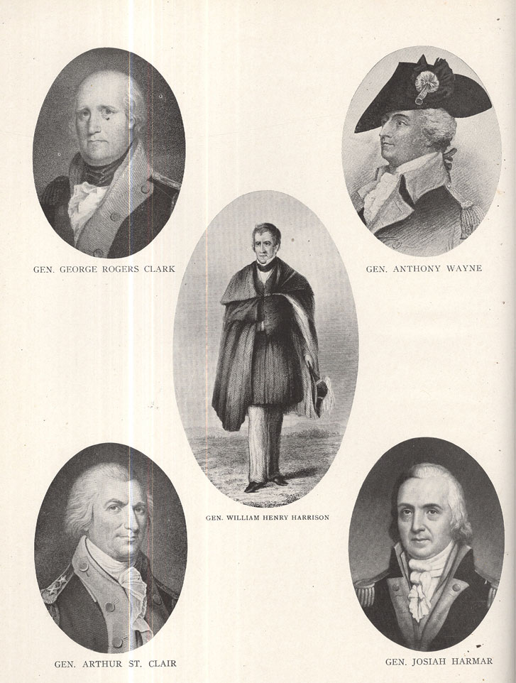
By the terms of the treaty of Fort Stanwix, concluded with the Iroquois or Six Nations (Mohawks, Onondagas, Senecas, Cayugas, Tuscaroras and Oneidas), October 22, 1784, the indefinite claim of said confederacy to the greater part of the valley of the Ohio was extinguished. The commissioners of Congress were Oliver Wolcott, Richard Butler and Arthur Lee. Corn-planter and Redjacket represented the Indians. This was followed in January, 1785, by the treaty of Fort McIntosh, by which the Delawares, Wyandots, Ottawas and Chippewas relinquished all claim to the Ohio Valley, and established the, boundary line between them and the United States to be the Cuyahoga River, and along the main branch of the Tuscarawas to the forks of the said river near Fort Laurens, thence westwardly to the portage between the head-waters of the Great Miami and the Maumee or Miami of the Lakes, thence down said river to Lake Erie, and along said lake to the mouth of the Cuyahoga River." This treaty was negotiated by George Rogers Clark, Richard Butler and Arthur Lee for the United States, and by the chiefs of the aforenamed tribes. A similar relinquishment was effected by the treaty of Fort Finney (at the mouth of the Great Miami), concluded with the Shawnees, January 31, 1786, the United States commissioners being the same as the foregoing, except the substitution of Samuel H. Parsons for Arthur Lee. The treaty of Fort Harmar, held by Gen. Arthur St. Clair, January 9, 1789, was mainly confirmatory of the treaties previously made. So also was the treaty of Greenville, of August 3, 1795, made by Gen. Anthony Wayne on the part of the United States, and the chiefs of I i of the most powerful tribes of the Northwestern Indians, which reestablished the 'Indian boundary line through the present State of .Ohio, and extended it from Laramie to Fort Recovery, and thence to the Ohio River, opposite the mouth of the Kentucky River.
The rights and titles acquired by the Indians under the foregoing treaties were extinguished by the general government, by purchase, in pursuance 4 of treaties subsequently made. The Western Reserve tract west of the Cuyahoga River was secured by a treaty formed at Fort Industry in 1805. The lands west of Richland and Huron counties and north of the boundary 'line
to the western limits of Ohio were purchased by the United States in 1818. The last possession of the Delawares was purchased in 1829; and by a treaty made at Upper Sandusky, March 17, 1842, by Col. John Johnston and the Wyandot chiefs, that last remnant of the Indian tribes in Ohio sold the last acre they owned within the limits of our State to the general government, and
30 - HISTORY OF MERCER COUNTY
retired the next year to the far West, settling at and near the mouth of the Kansas River.
FIRST OFFICERS OF THE TERRITORY.
Congress, in October, 1787, appointed Gen. Arthur St. Clair, Governor, Maj. Winthrop Sargent, Secretary, and James M. Varnum, Samuel H. Parsons and John Armstrong, judges of the Territory. The last named, however, having declined the appointment, John Cleves Symmes was appointed in his stead, in February, 1788. On the 9th of July, 1788, Governor St. Clair arrived at Marietta and, finding the Secretary and a majority of the judges present, proceeded to organize the territory. The Governor and judges (or a majority of them) were the sole legislative power during the existence of the first grade of Territorial government. Such laws as were in force in any of the States, and were deemed applicable to the condition of the people of the Territory, could be adopted by the Governor and judges, and, after publication, became operative, unless disapproved of by Congress, t0 which body certified copies of all laws thus adopted had to be forwarded by the Secretary of the Territory. The further duty of the judges, who were appointed to serve during good behavior, was to hold court four times a year, whenever the business of the Territory required it, but not more than once' a year in any one county.
THE SECOND GRADE OF TERRITORIAL GOVERNMENT.
After it should be ascertained that 5,000 free male inhabitants actually resided within the Territory, the second grade of Territorial government could, of right, be established, which provided for a Legislative Council, and also an elective House of Representatives, the two composing the lawmaking power of the Territory, provided always that the Governor's assent to their acts was had. He possessed the absolute veto power, and no act of the two houses of the Legislature, even if passed by a unanimous vote in each branch, could become a law without his consent. The conditions that authorized the second grade of Territorial government, however, did not exist until 1798, and it was not really put into operation until September, 1799, after the first grade of government had existed for I I years.
EARLY LAWS OF THE TERRITORY.
The first law was proclaimed July 25, 1788, and was entitled "An act for regulating and establishing the militia." Two days thereafter the Governor issued a proclamation establishing the county of Washington, which included all of the territory east of the Scioto River to which the Indian title had been extinguished, reaching northward to Lake Erie, the Ohi0 River and the Pennsylvania line being its eastern boundary; Marietta, the
AND REPRESENTATIVE CITIZENS - 31
seat of the Territorial government, also becoming the county seat of. Washington County. Quite a number of laws were necessarily adopted and published during 1788 and the following year. From 1790 to 1795 they published 64, 34 of them having been adopted at Cincinnati during the months of June, July and August of the last named year, by the Governor and Judges Symmes and Turner. They are known as the "Maxwell Code," from the name of the publisher, and were intended, says the author of "Western Annals," "to form a pretty complete body of statutory provisions." In 1798 I I more were adopted. It was the published opinion of the late Chief. Justice Chase, "that it may be doubted whether any colony, at so early a period after its first establishment, ever had so good a code of laws." Among them was that which provided that the "common law of England, and all statutes in aid thereof, made previous to the fourth year of James I., should be in full force within the Territory." Probably four-fifths of the laws adopted were selected from those in force in Pennsylvania; the others were mainly taken from the statutes of Virginia and Massachusetts.
ORGANIZATION OF THE SECOND GRADE OF TERRITORIAL GOVERNMENT.
The Governor having satisfactorily ascertained that the conditions existed entitling the Territory to the second grade of government, that is, that there were "5,000 free male inhabitants of full age" within the Territory, he, on the 29th day of October, 1798, took the preliminary steps to effect that object, by issuing his proclamation, directing the qualified voters to hold elections for Territorial Representatives on the third Monday of December, 1798. The election was held in pursuance of said proclamation, which resulted in the following gentlemen being chosen to constitute the popular branch of the Territorial Legislature for the ensuing two years :
MEMBERS OF TERRITORIAL LEGISLATURE OF 1799-1800.
Return Jonathan Meigs, Washington County.
Paul Fearing, Washington County.
William Goforth, Hamilton County.
William McMillan, Hamilton County.
John Smith, Hamilton County.
John Ludlow, Hamilton County.
Robert Benham, Hamilton County.
Aaron Caldwell, Hamilton County.
Isaac Martin, Hamilton County.
Shadrach Bond, St. Clair County.
John Small, Knox County.
John Edgar, Randolph County.
Solomon Sibley, Wayne County.
Jacob Visgar, Wayne County.
Charles F. Chabert de Joncaire, Wayne Co.
Joseph Darlington, Adams County.
Nathaniel Massie, Adams County.
James Pritchard, Jefferson County.
Thomas Worthington, Ross County.
Elias Langham,, Ross County.
Samuel Findlay, Ross County.
Edward Tiffin, Ross County.
The above-named gentlemen met at Cincinnati on the 22nd of January, 1799, and nominated 10 men, whose names they forwarded to the. United
32 - HISTORY OF MERCER COUNTY
States Congress, five of whom were to be selected by that body to constitute the Legislative Council of the Territory. They then adjourned to meet on the 16th of September, 1799. On the 22nd of March, 1799, either the United States Senate, the United States House of Representatives or the President of the United States, chose from among those whose names had been sug gested to them the following gentlemen, to compose the first Legislative Council of the Northwest Territory, their terms of office to continue five years, any three of whom to form a quorum : Jacob Burnet, of Cincinnati, Hamilton County; Henry Vandenburg, of Vincennes, Knox County; Robert Oliver, of Marietta, Washington County; James Findlay, of Cincinnati, Hamilton County; and David Vance, of Vanceville, Jefferson County. The Ordinance of 1787 named Congress as the authority in whom was vested the right t0 select five from the list of 10 persons to constitute the Territorial Council. But it will be borne in mind that said ordinance was passed by a Congress that legislated in pursuance of the Articles of Confederation, while yet we had neither President nor United States Senate, hence authority was given to Congress to make the selection. But it is highly probable that the aforesaid authority was subsequently transferred to the President, or to the Senate, or to them jointly.
FIRST COUNCIL AND HOUSE OF REPRESENTATIVES.
Both the Council and House of Representatives met at Cincinnati, September 16, 1799, and effected a permanent organization. The Council perfected its organization by the election of the following officers : President, Henry Vandenburg; secretary, William C. Schenck; door-keeper, George Howard; sergeant-at-arms, Abraham Cary. The House of Representatives completed its organization by electing, as its officers, the following gentlemen: Speaker of the House, Edward Tiffin; clerk, John Riley; door-keeper, Joshua Rowland; sergeant-at-arms, Abraham Cary.
Thirty bills were passed at the first session of the Territorial Legislature, but the Governor vetoed II of them. They also elected William Henry Harrison, then Secretary of the Territory, a delegate to Congress, by a vote of 11 to 10 that were cast for Arthur St. Clair, Jr., son of the Governor, then a promising young lawyer of Cincinnati, and who then held the office of Attorney-General of the Territory. The first session of the Territorial Legislature was prorogued by the Governor, December 19, 1799, until the first Monday of November, 1800, at which time they reassembled and held the second session at Chillicothe, which, by an act of Congress, of May 7, 1800, was Lade the seat of the Territorial government, until otherwise ordered by the Legislature. This, the second session of the Territorial Legislature, was of short duration, continuing only until December 9, 1800.
AND REPRESENTATIVE CITIZENS - 33
On May 9, 1800, Congress passed an act establishing the Indiana Territory, with boundaries including the present States of Indiana and Illinois, and William Henry Harrison having accepted the office of Governor of said Territory, it devolved upon the Territorial Legislature, at its second session, not only to elect a delegate to Congress to fill the vacancy occasioned by his resignation, but also to elect a delegate to serve during the succeeding Congress. William McMillan was elected to fill the vacancy and Paul Fearing, of Marietta, was elected to serve from the 4th of March, 180r, to the 4th of March, 1803. By the organization of the Indiana Territory, the counties of St. Clair, Knox and Randolph were taken out of the jurisdiction of the Northwest Territory, and with them, of course, Henry Vandenburg; of Knox County, president of the Council ; also Shadrach Bond, of St. Clair County; John Small, of Knox County, and John Edgar, of Randolph County, members of the popular branch of the Legislature.
On the 23rd of November, 1801, the third session of the Territorial. Legislature was commenced
at Chillicothe, pursuant to adjournment. The time for which the members of the House of Representatives were elected having expired, and an election having been held, quite a number of new members appeared. The Council remained nearly as it was at the previous sessions, there being not more than two changes, perhaps only one, that of Solomon Sibley, of Detroit, Wayne County„ who took the place of Henry Vandenburg, thrown into the new Territory. Robert Oliver, of Marietta, Washington County, was chosen president of the -Council in place of Henry Vandenburg. The officers of the House of Representatives were as follows: Speaker, Edward Tiffin; clerk, John Riley ; door-keeper, Edward Sherlock. The third session of the Legislature continued from the 24th of November, 18o1, until the 23rd of January, 1802, when it adjourned to meet at Cincinnati on the fourth Monday of November following, but that fourth session was never held, for reasons made obvious by subsequent events.
Congress, on the 30th of April, 1802, had passed "An act to enable the people of the eastern division of the Territory northwest of the river Ohio to form a constitution and State government, and for the admission of such State into the Union on an equal footing with the original States, and for Other purposes." In pursuance of the aforesaid enactment, an election had been ordered and held throughout the eastern portion of the Territory, and members of a constitutional convention chosen, who met at Chillicothe on the first day of November, 1802, to perform the duty assigned them. When the time had arrived for commencing the fourth session of the Territorial Legislature, the aforesaid constitutional convention was in session and had evidently nearly completed its labors, as it adjourned on the -29th of said Month. The members of the Legislature (eight of whom were also members
34 - HISTORY OF MERCER COUNTY
of the convention) therefore, seeing that a speedy termination of the Territorial government was inevitable, deemed it inexpedient and unnecessary to hold the proposed session.
The Territorial government was ended by the organization of the State government, March 3, 1803, pursuant to the provisions of a constitution formed at Chillicothe, November 29, 1802, by the following named gentlemen; Joseph Darlington, Israel Donalson and Thomas Kirker, of Adams County; James Caldwell and Elijah Woods, of Belmont County; Philip Gatch and James Sargent, of Clermont County; Henry Abrams and Emanuel Carpenter, of Fairfield County; John W. Browne, Charles Willing Byrd, Francis Dunlavy, William Goforth, John Kitchel, Jeremiah Morrow, John Paul, John Riley, John Smith and John Wilson, of Hamilton County; Rudolph Bair, George Humphrey, John Milligan, Nathan Updegraff and Basil Wells, of Jefferson County; Michael Baldwin, Edward Tiffin, James Grubb, Thomas Worthington and Nathaniel Massie, of Ross County; David Abbott and Samuel Huntington, of Trumbull County; and Ephraim Cutler, Benjamin Ives Gilman, Rufus Putnam and John McIntire, of Washington County. Joseph Darlington, of Adams County; Francis Dunlavy, Jeremiah. Morrow and John Smith, of Hamilton County; John Milligan, of Jefferson County; Edward Tiffin, and Thomas Worthington, of Ross County; and Ephraim Cutler, of Washington County, were the eight gentlemen of the last Territorial Legislature that were also elected members of the constitutional convention.
LOCAL COURTS AND COURT OFFICERS.
Among the earliest laws adopted by the Territory of Ohio was one which provided for the institution of a county court of common pleas, to be composed of not less than three nor more than five judges; commissioned by the Governor, who were to hold two sessions in each year. Pursuant to its provisions, the first session of said court was held in and for Washington County, September 2, 1788. The judges of the court were Gen. Rufus Putnam, Gen. Benjamin Tupper and Col. Archibald Crary. Col. Return Jonathan Meigs was clerk and Col. Ebenezer Sproat was sheriff. Elaborate details of the opening of this, the first court held in the Northwest Territory, have come down to us, showing it to have been a stylish, dignified proceeding. Briefly, "a procession was formed at the Point (the junction of the Muskingum with the Ohio River) of the inhabitants and the officers from Fort Harmar, who escorted the judge of the court, the Governor of the Territory and the Territorial judges to the hall appropriated for that purpose, in the northwest blockhouse in 'Campus Martius.' " "The procession," says Mitchener, "was headed by the sheriff, with drawn sword and baton of office."
AND REPRESENTATIVE CITIZENS - 35
"After prayer by Rev. Manasseh Cutler, the court was organized by reading the commissions of the judges, clerk and sheriff; after which the sheriff proclaimed that the court was open for the administration of even-handed justice to the poor and the rich, to the guilty and the innocent, without respect of persons; none to be punished without a trial by their peers, and then in pursuance of the laws and evidence in the case."
On the 23rd day of August, 1788, a law was promulgated for establishing "general courts of quarter sessions of the peace." This court was composed of not less than three nor more than five justices of the peace, appointed by the Governor, who were to hold four sessions in each year: The first session of this court was held at "Campus Martius" September 9, 1788. The commission appointing the judges thereof was read. Gen. Rufus Putnam and Gen. Benjamin Tupper, says Mitchener, constituted the justices of the quorum, and Isaac Pearce, Thomas Lord and Return Jonathan Meigs, Jr., the assistant justices; Col. Return Jonathan Meigs, Sr., was clerk. Col. Ebenezer Sproat was sheriff of Washington County 14 years. The first grand jury of the Northwest Territory was impaneled by this court, and consisted of the following gentlemen : William Stacey (foreman), Nathaniel Cushing, Nathan Goodale, Charles Knowles, Anselm Tupper, Jonathan Stone, Oliver Rice, Ezra Lunt, John Matthews, George Ingersoll, Jonathan Devol, Jethro Putnam, Samuel Stebbins and Jabez True.
THE FIRST COUNTIES ORGANIZED.
Washington County, then embracing the eastern half of the present State of Ohio, was the only organized county of the Northwest Territory until early in 1790, when the Governor proclaimed Hamilton County, which included all the territory between the Great and Little Miami rivers, and extended north to the "Standing Stone Forks" on the first named stream.
HOSTILITY OF THE INDIAN TRIBES-MILITARY EXPEDITIONS.
From the time of the organization of the government of the Northwest Territory, in 1788, until the ratification of the treaty of Greenville, sometimes called "Wayne's treaty," in 1795, the attitude of many of the Western Indian tribes toward the white settlers in the Northwest Territory was that of extreme, unrelenting hostility. The military organization which had marched against them, before the establishment of civil government in the great Northwest, had signally failed to subjugate them, or secure a permanent cessation of hostilities. The disastrous expeditions of General Braddock in 1755, of Major Wilkins in 1763, of Colonel Bradstreet in 1764, 0f Colonel Lochry in 1781, and of Colonel Crawford in 1782, and the disgraceful and murderous expedition against the Moravian Indians on the Tuscarawas, in the last named year, only tended to inflame the hostile Indian tribes, and in-
36 - HISTORY OF MERCER COUNTY
spire them with greater courage in their hostile movements and aggressive measures against the white settlers. The fruitless, if not abortive, campaigns of Colonel McDonald in 1774, of General McIntosh in 1778, and of General Broadhead in 1781, of course led to no salutary results. Even the successful campaigns of Colonel Boquet in 1763-64, of Lord Dunmore and General Lewis in 1774, and of Gen. George Rogers Clark in 1778, failed to secure a permanent peace with the Western Indian tribes. The inhabitants of the Northwest Territory were, therefore, from the 7th day of April, 1788, when the first immigrants arrived at the mouth of the Muskingum, until the treaty of Greenville was concluded in August, 1795, constantly liable to the stealthy but deadly attacks of the perfidious, merciless savage tribes of the Northwest. But they met their dastardly, cruel, relentless foes in the spirit
PLAN OF ST. CLAIR'S BATTLE-FIELD.
References: A.—High ground, on which the militia were encamped at the commencement of the action. B. C.—Encampment of the main army. D.—Retreat of the militia at the beginning of the battle. E.—St. Clair's trace, on which the defeated army retreated. F.—Place where General Butler and other officers were buried. G.—Trail to Girty's Town, on the river St. Mary's, at what is now the village of St. Marys. H.—Site of Fort Recovery, built by Wayne. I.—Place where a brass cannon was found buried in 1830; it is on the bottom where the Indians were three times driven to the highland with the bayonet.—From Howe's "Historical Collections of Ohio."
of genuine manhood—of true, determined, unflinching heroism! They were men worthy of the heroic age of the West ! Bravely did they bear themselves (luring those seven years of toil and privation, of dread and apprehension, of suffering and sorrow, of blood and carnage.
To secure the speedy termination of those savage atrocities, the national government early organized a number of military expeditions, the first of Which being that of Gen. Josiah Harmar, in 1790, who was then commander-in-chief of the military department of the West. He had a few hundred reg-
AND REPRESENTATIVE CITIZENS - 37
ular troops under his command, stationed chiefly at Fort Harmar and Fort Washington, which served as the nucleus of his army, The great body of his troops, however, numbering in all above 1,400, were Pennsylvania and Kentucky volunteers, the former being under the command of Col. John Hardin, and the latter of Colonel Trotter. The expedition left Fort Washington and marched to the junction of the St. Joseph and St. Mary's rivers (now Fort Wayne, Indiana), where detachments of the army, under command of Colonel Hardin, on the 19th and 22nd day of October, encountered the enemy and suffered mortifying defeats. Of course, the campaign failed to give peace or relief from apprehended barbarities.
The next year Gen. Arthur St. Clair, the Governor of the Territory, who had a Revolutionary record of patriotism and ability, organized an expedition, whose strength somewhat exceeded that of General Harmar's. It met with a most disastrous defeat, November 4, 1791, near the head-waters of the Wabash, now in Mercer County, Ohio, the battle-field being known as Fort Recovery. Of 1,500 men in the battle more than half were either killed or wounded. This defeat proved a great calamity to the disheartened and greatly harassed pioneers of the Northwest Territory.
Immediately after the defeat of General St. Clair, the Federal government took the preliminary steps to raise a large army to operate against the hostile tribes, for the purpose of finally and permanently subjugating them. Military preparations, however, progressed slowly, and the summer of 1794 had nearly passed before the confederated hostile Indian tribes were met ih battle array by General Wayne's army. The battle was fought at the Maumee Rapids, near Perrysburg and Fort Meigs, in Wood County, Ohio, and is known as the battle of Fallen Timber, though sometimes called the "Battles of the Maumee." Wayne's army numbered more than 3,00o men, well disciplined and ably officered, 1,600 of whom being mounted volunteer troops
PLAN ILLUSTRATING THE BATTLES OF THE MAUMEE.
Explanations.—The map above shows about eight miles of the country along each side of the Maumee, including the towns of Perrysburg, Maumee City and Waterville.
Fort Meigs, memorable from having sustained two sieges in the year 1813, is shown on the east side of the Maumee, with the British batteries on both sides of the river, and above the British fort, the position of Proctor's encampment.—From Knapp's "History of the Maumee Valley."
38 - HISTORY OF MERCER COUNTY
from Kentucky, commanded by Gen. Charles Scott, of said State, who was the second ranking officer in the army and who, as well as Gen. Henry Lee (the "Light-Horse Harry" of the Revolution) and Gen. William Darke, had been favorably considered by President Washington in connection with the chief command of the expedition. The choice, however, fell upon General Wayne, the old companion-in-arms of the President, and to him is justly ascribed the honor of defeating the Indian tribes commanded by the celebrated Shawnee chief, Blue Jacket, on the Maumee, August 20, 1794, and of permanently breaking the power 0f a very formidable Indian confederacy. Cessation of hostilities followed this victory, and a peace, which the general government had vainly sought by friendly negotiation, was secured—a peace which continued for many years, even until after the Northwest Territory had "ceased to be," and the important incidents and events connected therewith had passed into history.
EARLY FORTS OF THE NORTHWEST TERRITORY.
Fort Washington.—A military post was established at Losantiville (now Cincinnati) and named Fort Washington, after Gen. George Washington, being built by General Doughty in the fall of 1789. It was from this point that the first movement, under General Harmar, was made against the Indians, he being the commandant at the fort, and we may also add that the subsequent expeditions of Generals St. Clair and Wayne started from Fort Washington..
Fort Hamilton.—In the early part of September, 1791, the main. body of General St. Clair's army, under General Butler, took up the line of march from Fort Washington, and, moving northward 25 miles, on the eastern bank of the Great Miami erected a fort which they called Fort Hamilton, after Gen. Alexander Hamilton, and which was completed October 4, 1791. It was named by General St. Clair, and was located within the present limits of Butler County, Ohio.
Fort Jefferson.—General St. Clair's army marched from Fort Hamilton a distance of 42 miles, and on October 12, 1791, built Fort Jefferson, six miles south of Greenville, in what is now Darke County, Ohio, being named in honor of Thomas Jefferson. The army remained here until October 24th, then marched nine days, and on November 3rd reached the site of the present
town of Fort Recovery, Ohio, and encamped at the head-waters of the Wabash.
Fort Greenville.—General Wayne, having received the appointment to the command of the Western troops against the Indians, was gathering his forces from 1792, to August, 1793. He left Camp Hobson's Choice, near Fort Washington, on October 6, 1793, advanced to the southwest branch of
AND REPRESENTATIVE CITIZENS - 39
the Great Miami, within six miles of Fort Jefferson, and in November, 1793, built Fort Greenville, which stood in the vicinity of what is now the town of Greenville, Darke County.
Fort Recovery.—On December 23, 1793, General Wayne gave orders for the erection of a fort on the site of St. Clair's defeat, in 1791. For that purpose he ordered Maj. Henry Barbee with eight companies of infantry and a detachment of artillery to proceed to the ground and erect a fort, which he named Fort Recovery. This was located on the site of the present town of Fort Recovery, in Mercer County. In connection with the building of this fort, we may state that on the arrival of the soldiers, and before they could pitch their tents, they were required to collect the bones of St. Clair's soldiers and carry them out before they could make their beds. The next day 600 skulls were found; the bones were all buried.
Fort Defiance was commenced by General Wayne August 8, 1794, at the junction of the Auglaize and Maumee rivers, and finished August 30th. It consisted of slight earthworks—a stockade with four block-houses, one at each angle. The earthworks of the fort can, to this day be readily traced.
PLAN OF FORT DEFIANCE.
Explanations.—At each angle of fort was a block-house. The one next the Maumee is marked A, having port-holes B, on the three exterior sides, and door D, and chimney C, on the side facing to the interior. There was a line of pickets on each side of the fort, connecting the block-houses by their nearest angles. Outside of the pickets and around the block-houses was a glacis, a wall of earth eight feet thick, sloping upwards and outwards from the feet of the pickets, supported by a log wall on the side of the ditch and by fascines, a wall of fagots, on the side next the Auglaize. The ditch, fifteen feet wide and eight feet deep, surrounded the whole work except on the side toward the Auglaize; and diagonal pickets, eleven feet long and one foot apart, were secured to the log wall and projected over the ditch. E and E were gateways. F was a bank of earth, four feet wide, left for a passage across the ditch. G was a falling gate or drawbridge, which was raised and lowered by pulleys, across the ditch, covering it or leaving it uncovered at pleasure. The officers' quarters were at H, and the storehouses at I. At K, two lines of pickets converged towards L, which was a ditch eight feet deep, by which water was procured from the river without exposing the carrier to the enemy. M was a small sand-bar at the point.—From Knapp's "History of the Maumee Valley."
40 - HISTORY OF MERCER COUNTY
Fort Adams.—General Wayne built this fort August 2, 1794, on the south bank of the St. Mary's River, in section 24, Dublin township, Mercer County, on the land subsequently owned by Joseph Palmer, 12 miles east of the Indiana line. It was named by General Wayne in honor of John Adams, then Vice-President of the United States.
Fort Industry was erected by General Wayne in 1794, near the confluence of Swan Creek with the Maumee River, and placed in charge of Capt. J. Rhea, who held the same until after the British evacuated all the posts in the Northwest Territory.
Fort. Deposit was built by General Wayne in August, 1794, being located seven miles from the foot of the Maumee Rapids for the reception of stores and baggage, hence the name of the fort, and to better reconnoitre the enemy's ground, which lay behind a thick wood and the British fort (Fort Miami).
Fort Wayne.—The site of this fort was at the junction of the St. Joseph and St. Mary's rivers. It was commenced September 17, and finished October 22, ,1794. It occupied a commanding position on the south side of the Maumee River, where the Maumee towns were located. Colonel Hamtramck, on its completion, assumed command of the post with the following sub-legions : Captain Kingsbury's, 1st ; Captain Greaton's, 2nd; Captains Spark and Reed's, 3rd; Captain Preston's, 4th ; and Captain Porter's artillery. After firing 15 rounds of cannon, Colonel Hamtramck gave it the name of Fort Wayne, after their gallant and victorious general. This fort was dismantled in 1804, when a new and larger one was built in its place. This was also taken down, in 1815, and a more substantial one erected, which consisted of a stockade, block-houses and officers' quarters.
Fort Gower was erected_ by Lord Dunmore in 1774, and named in honor of Earl Gower. It was situated in what is now Athens County.
Fort Junandat was built by the French in 1750, on the east bank of the Sandusky River.
Fort Piqua, erected prior to the settlement of the country, stood at Upper Piqua, on the west bank of the Miami River. It was used for a place of deposit for stores for the army of Wayne. The portage from here to Fort Loramie, 14 miles, hence to St. Marys, 12 miles, was all the land carriage from the Ohio to ,Lake Erie. Loaded boats frequently ascended to Fort Loramie, the loading taken out and hauled to St. Marys; the boats also were moved across on wheels, again l0aded and launched for Fort Wayne, Fort Defiance and the lake. The last commander of Fort Piqua was Capt. J. N. Vischer, in 1794. During that year two freighted boats, guarded by an officer and 23 men, were attacked by the Indians near the fort, and all massacred. Captain Vischer heard the firing, but from the weakness of his command could tender no assistance. The plan of the Indians doubtless was to make the
AND REPRESENTATIVE CITIZENS - 41
attack in hearing of the fort, and thereby induce them to sally out in aid of their countrymen, defeat all and take the fort. The commander was a discreet officer, and, aware of the subtleness of the enemy, had the firmness to save the fort. The track of the pickets, the form of the river bastion, still mark the site of Fort Piqua.
Fort St. Clair—About a mile west of Eaton, the county seat of Preble County, is the site of Fort St. Clair, erected in the severe winter of 1791-92, by Maj. John S. Gano, of the Territorial militia. Gen. William Henry Harrison, then an ensign, commanded a guard every other night for about three weeks, during the building of the fort. They had neither fire nor covering of any kind, and suffered much from the intense cold.
Fort Seneca was a military post built in the War of 1812, and was located nine miles north of Tiffin, on the west bank of the Sandusky Rivet. It was occupied by. General Harrison's troops at the time of the attack on Fort Stephenson, which was only a few miles below,. on the river.
Fort Stephenson, or Sandusky, was built at a very early day, and was within the present limits of Sandusky City. This fort was gallantly defended by Col. George Croghan on the 2nd of August, 1813, against an overwhelming force of British and Indians.
Fort Steuben was situated where the city of Steubenville now stands, being located on North High street, near the site of the female seminary. It was built in 1786 by Major Hamtramck, and was garrisoned by United States troops under command of Colonel Beatty, but was dismantled at the time of Wayne's victory in 1794, and other buildings erected. It was occupied as a military post until 1819, when the reservation on which it stood was sold. The remains of the building were removed about 1848. In connection with the second structure, we would state it was besieged by the Indians under Tecumseh and his brother, the Prophet, in August and September, 1812, and was successfully defended until relieved by the troop's under General Harrison.
Fort Loramie was built by General Wayne. in 1794, on Loramie's Creek, being 16 miles northwest of the present city of Sidney, Shelby County, Ohio. It received its name from a. Frenchman named Loramie, who established it as a trading post and gave his name to the stream, which flows along its southern side.
Fort Harmar.—There were two forts by this name, both of which were built upon the same round by Gen. Josiah Harmar, west of the Muskingum River, opposite where Marietta now stands.. The first fort stood on what is called the "second bottom," being elevated above the 'ordinary flood of the river, while between it and the banks of the river was a lower or first bottom depressed about six feet, to which the descent was a gradual slope.
42 - HISTORY OF MERCER COUNTY
The first formed a regular hectagon, and the area embraced within its walls contained about three-fourths of an acre. To communicate with Campus Martius from Fort Harmar, a path was cut and cleaned through the forest. The second fort was erected "on the right bank of the Muskingum River opposite to Marietta, and at its junction with the Ohio." It was named in honor of General Harmar, and was commenced in 1785, but not finished until 1786.
Fort Amanda.—Colonel Poague, with his regiment, built the fort at the Ottawa towns, in what is now Allen County, on the Auglaize, 12 miles from St. Marys, and named it Fort Amanda, in honor of his wife. This regiment was at the same time employed in constructing boats and canoes, and in escorting provision trains between the posts. These were some of the exertions and movements made in our territory in preparation for the main expedition contemplated against Malden. The fort was situated near the west bank of the Auglaize River with about an acre of land. The pickets were from 10 to 12 feet high, and sunk two or three feet in the ground. There were four block-houses, one at each corner ; the second story projected over the pickets three or four feet and was pierced with port-holes, from which the soldiers could defend the fort in case of attack ; the first story was occupied by soldiers and company officers as sleeping rooms. The blockhouse in the southeast corner was the largest and was used mainly as officers' quarters. There was also a large cabin in the center of the fort, which was used as a storehouse for supplies for the army, as the soldiers wintered all one winter, if not two, at this point. Again, the old fort was used as one of the first postoffices in Allen County, as well as the first place of preaching. Fort Amanda served as an intermediate storehouse and point of concentration between St. Marys, Urbana and Upper Sandusky on the one side, and Forts Wayne and'Defiance on the other. Here a cemetery was established for the interment of the nation's dead during the occupation of the fort. This cemetery was continued in use' by the whites after the settlement, and is still a monument to that army.
Fort Auglaize.—This old fort, east of Wapakoneta, was built by the French in 1748.
Fort McIntosh was built by Gen. L. McIntosh in October, 1778, he having succeeded General Hand in the command. This fort was built for the reception and security of prisoners and slaves upon the Indian side of the Ohio River, with barracks for a regiment. Gen. Arthur Lee, in 1784, thus describes it : "It is -built of well hewn logs, with four bastions—its figure is an irregular square—the face to the river being longer than the side to the land. It is almost equal t0 a square of 50 yards—it is well built and strong against musquetry." General McIntosh, leaving a portion of his
AND REPRESENTATIVE CITIZENS - 45
men to complete the fortification, set out at the head of 1,000 men to build Fort Laurens at the forks of the Muskingum, which he accomplished by December. The object of this was to strike a blow at the Indian town on the Sandusky River—but the season being too far advanced he concluded to defer it until spring, and leaving Col. John Gibson in command, with 150 men to garrison Fort Laurens, he returned in December to Pittsburg. Fort Laurens was attacked in January by about B00 Indians. After frequent parleys and a promise of a barrel of flour, they agreed to send in proposals for peace, but instead of this they retreated. Colonel Gibson relying on their word, and supposing they had left, permitted Captain Clarke, of the Eighth Pennsylvania Regiment, with 15 men, to set out on his return to Fort McIntosh, whence they had gone to escort some provisions. About three miles from Fort Laurens, he was attacked by the notorious and infamous Simon Girty at the head of a band of Mingos. Two of his men were killed, four wounded and one taken prisoner; the remainder escaped to the fort. The garrison, after a long, distressing siege of four weeks, was relieved by General McIntosh at the head of nearly B00 men, who advanced rapidly to raise the siege by the route of Fort McIntosh. As the army came in sight of Fort Laurens, the garrison fired a salute, which so alarmed the pack-horses that they broke loose, by which means much 0f the provisions was lost and the horses never recovered. Many of the most famished soldiers were injured by the surfeit occasioned by overeating. They returned to Fort McIntosh, where they were met by their friends from the settlements and abundantly supplied. A new body of troops supplied 'those worn down by the fatigues of the siege, and the foft was left in command of Major Vernon. General McIntosh endeavored to get up an expedition against the Sandusky towns, but overcome by the great exertions necessary, his health much impaired and his spirits broken down, he was forced to resign.. Col. Daniel Broadhead succeeded General McIntosh in command, but his position was judiciously chosen, as it commanded not only the mouth of the Muskingum, but swept the waters of the Ohio from a curve in the river both above and below the fort. It was placed under the command of Maj. John Doughty, and occupied by a detachment of United States troops from 1785 to September, 1790. General Broadhead, in his letter to General Armstrong, says : "It was owing to the General's determination to take Detroit that the very romantic building called Fort McIntosh was built by the hands of hundreds who would rather have fought than wrought."
Fort Laurens was erected in November, 1778, at the forks of the Muskingum, on the right bank of the Tuscarawas River, half a mile below the site of Bolivar, Tuscarawas County, by Gen. L. McIntosh, of the Revolution. In December following it was occupied by 1,000 soldiers. Bef0re the troops
46 - HISTORY OF MERCER COUNTY
left, he placed Col. John Gibson in command, with 150 men to garrison it, and on July 31, 1779, it was evacuated by order of General Broadhead. Henry Laurens, after whom the fort was named, was a distinguished Revolutionary patriot. Upon the resignation of John Hancock he was appointed president of the General Congress in November, 1777. He was captured by the British while on his way to Holland to negotiate a treaty with the United Netherlands in 1780 and was committed to the Tower on the 6th of October. He was eventually discharged and was appointed by Congress one of the ministers for negotiating peace with Great Britain, in conjunction with Dr. Franklin, John Adams and John Jay. He signed the preliminaries of peace on November 30, 1782, and then returned to Carolina, where he died t0 year later.
Fort Campus Martins was erected by the Ohio Company of Associates at Marietta, its erection being begun under the direction of Gen. Rufus Putnam, on April 7, 1788. It was not finally completed with palisades and outworks or bastions, until the winter of 1790. The walls, which formed a regular parallelogram, were each 180 feet long. At each corner was a strong block-house surmounted by a tower or sentry box, 26 feet square at the base, and at the top ,20 feet, with projection of 6 feet beyond the main walls of the fort. The buildings within the inclosure were constructed of whip-sawed timber about 4 inches thick, dove-tailed at the corners and covered with shingle roofs, each room of which had fire-places and brick chimneys. The towers and bastions were bright with whitewash. The first court ever held in the Northwest Territory was opened in the northwest block-house of Campus Martius (Marietta), August 2, 1788, and was held during the Indian war. At the close of the war and until the old Court House of Washington County was built, the courts were held in the upper story of a block-house at the junction of the Muskingum River with the Ohio. The first Washington County Court House was built in 1798.
Fort Barbee was erected by Colonel Barbee near the west bank of the St. Mary's River,' on the site of what afterwards became a Lutheran cemetary, in the town of St. Marys.
Fort Jennings was erected by Colonel Jennings' regiment in September, .1812, by order of General Harrison. It was intermediate between St. Marys and Defiance, and was situated in what is now Putnam County.
Fort Dillies was erected in 1792 on the west side of the Ohio, opposite Grave Creek, in what is now Belmont County.
Fort McArthur was built in January, 1813, in Hardin County, at the head of the Scioto River, and on General Hull's road, three miles southwest of the present city of Kenton, and was named after Gen. Duncan McArthur.
AND REPRESENTATIVE CITIZENS - 47
He built two block-houses on the south side of the Scioto, each 20 by 24 feet, connected by a strong blockade, covering an area of near half an acre.
Fort Meigs was erected by General Harrison, February 1, 1813, at the Maumee Rapids, in Wood County, and named by him in honor of Governor Meigs, of Ohio. General Proctor with the British forces, and Tecumseh with the Indians, were defeated at the siege of Fort Meigs. The fort was of an oblong shape, with bastions and block-houses, with two transverses running from one end to the other. It originally covered about 10 acres of ground, but through the action of the elements it rapidly disappeared.
Fort Miami was at the foot of the Maumee Rapids, seven miles from Fort Deposit, and stood on the northwestern bank of the Maumee, near where Maumee City now stands.
Fort Necessity was built June 22, 1812, by Colonel Findlay, on the road from Fort McArthur to Blanchard's Fork, and is situated near what is now the town of Dunkirk, in Hardin County.
Fort Findlay.—A block-house called Fort Findlay was built at Blanchard's Fork June 25, 1812.
Fort Ball was erected opposite the site of the present city of Tiffin, on the west bank of the Sandusky River. It was a small stockade with a ditch, occupying about one-third of an acre, and was used principally as a military depot.
CHAPTER II
COUNTY ORGANIZATION AND HISTORY
Mercer County was erected April 1, 1820, by virtue of an act of the State Legislature for the erection of counties in Northwestern Ohio, which was passed February 12, 1820. This act provides that "all that part of lands lately ceded by the Indians to the United States, which lies within the State of Ohio, shall be and the same is hereby erected into fourteen separate and distinct counties, to be * * * named as follows : Van Wert, Mercer, Putnam, Allen, Hancock, Hardin, Crawford, Richland, Seneca, Sandusky, Wood, Henry, Paulding and Williams." Mercer County, according to the provisions of this act, was to include all of ranges I, 2, 3 and 4, south of Van Wert County to the northern boundaries of counties theretofore organized. The same act also provided that Van Wert and Mercer counties be attached to Darke County until otherwise ordered. Mercer County was subsequently detached, in 1824, and Van Wert, in October, 1837. Mercer County was organized by an act of the Legislature, dated January 2, 1824, Celina being named as the county seat. The county originally contained approximately 576 square miles of land, with 4 townships, but at present its area is 460 square miles, with 14 townships. The Legislature of 1849 carved out the county of Auglaize, and in so doing took a portion of Mercer County from the eastern side. Mercer County was partially compensated for this loss in area by having set over to it that part of Darke County lying north of its present northern boundary line and south of the old Indian boundary line. The county is bounded on the north by Van Wert County, on the east by Auglaize, on the south by Darke and on the west by the State of Indiana.
GEN. HUGH MERCER.
Mercer County was named in honor of Gen. Hugh Mercer, a distinguished officer of the Revolution, wh0 was born in Aberdeen, Scotland, in 1723 and educated in the university, there, where he studied medicine. He
AND REPRESENTATIVE CITIZENS - 49
served as surgeon's mate in the army of Prince Charles Edward, the hero of the civil war of 1745, in the battle of Culloden. In 1746 he came to America and settled in Cumberland County, Pennsylvania, within a few miles of the site of the present town of Mercersburg. In Braddock's expedition, in 1755, as lieutenant-colonel, he commanded a regiment of volunteers. He also t0ok part in the expedition under Col. John Armstrong against Kittanning, 20 miles from Fort Du Quesne, serving under a commission as captain. Upon the capture of Fort Du Quesne by Gen. John Forbes, on November 25, 1758, Captain Mercer was placed in charge with 280 men. He made immediate provision for the securing of that post, which had cost so much blood and
treasure. A small fortification was thrown up on the bank of the Monongahela and named Fort Pitt in honor of the English minister. Col. Hugh Mercer was its first commandant. In the Revolutionary struggle he was commissioned brigadier-general by Congress and took a prominent part until he was mortally wounded on the battle-field of Princeton, January 3, 1777, dying io clays later. He was,buried at Princeton, but his body was afterwards brought to Philadelphia and buried in Christ Churchyard. On November 26. 1840, his remains were disinterred and removed with appropriate hon0r to the Laurel Hill Cemetery, where a monument was erected by the St. Andrew Society.
POLITICAL DIVISIONS OF THE COUNTY.
These consist of the 14 townships, viz., Black Creek, Dublin, Union, Center, Jefferson, Franklin, Marion, Granville, Gibson, Recovery, Washington, Liberty, Hopewell and Butler. Of these, Liberty, Black Creek, Dublin, Washington and Union are regularly bounded as congressional townships,