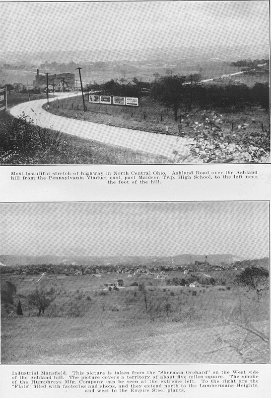
|
The total population of Ohio in 1930 was 6,646,697 an increase of 887,303 over 1920 when the state had a population of 5,759,394. The urban population has steadily grown in the past decade. Great numbers of people have been leaving the farms and the smaller villages. Eighty per cent of the growth in the state in the decade from 1920 HISTORY OF NORTH CENTRAL OHIO - 37 to 1930 has been in the urban counties while most all the strictly farming counties had a loss in population. It is stated that now more than forty percent of the people of Ohio are in cities of 100,000 or more. Many villages once flourishing have barely held their own. People who used to come to the villages regularly to get their mail and do their trading are served by the rural routes of which there are 227 in the seven counties of North Central Ohio. The smaller cities have all shown substantial growth. Evidencing the urban growth in North Central Ohio, the population in 1930 of 13 of these communities of over 2,500 was as folows: Ashland 11,141; Bellevue 6,256 ; Elyria 25,633 ; Lorain 44,512 ; Mansfield 33,- 525; Medina 4,071; Mt. Vernon 9,370 ; Orrville 4,427; Rittman 2,785; Shelby 6,198 ; Wadsworth 5,930 ; Willard 4,514 ; Wooster 10,742; a total of 169,212 and an increase of 27,604 over their 1920 population. A number of unincorporated villages in North Central Ohio showed increases in the 1930 census. CHAPTER II. GEOLOGY, TOPOGRAPHY, RESOURCES WHAT NORTH CENTRAL OHIO OWES TO THE ICE AGE-"GRIST OF THE GLACIER"- RICH AGRICULTURAL REGION-COAL-WORLD'S LARGEST SANDSTONE QUARRIES AT SOUTH AMHERST-OIL AND GAS. All of the seven counties of North Central Ohio, with the exception of a small part of Knox County are in the glaciated area of Ohio, some of the richest farming areas in all the state. Parallel with the shore of Lake Erie in Lorain County are three sand ridges regarding which the late Dr. G. Frederick Wright of Oberlin College, former president of the Ohio State Archaeological and Historical Society, describes most interestingly in a history of the county in 1916. Speaking of the close of the Ice Age in what is now Northern Ohio when conditions were similar to those of Greenland today, the glacial ice a mile deep, he mentions that when the ice was melting back from the southern shore of Lake Erie, a lake was formed in front of the ice, the water rising to the level of the lowest pass into the Mississippi Valley from the Maumee into the Wabash. Through this pass there is an abandoned river channel as wide and deep as that of the Niagara below Buffalo, leading from the Maumee Valley to the Valley of the Wabash, this evidently having been the outlet of the Northern Ohio drainage basin while the ice was melting back. A shore line was formed at about 200 feet above the present level of the lake. During a period of probably many centuries there was thrown up a sand and gravel beach. This was the origin of the 200-foot sand ridge in the county and known as South Ridge. In Ridgeville and Eaton townships it is called Butternut Ridge. Its course is traced through South Amherst and Brownhelm to Erie County. Further melting of the ice, Dr. Wright pointed out, gave rise to what are known as the 150-foot (Center) Ridge and a 100-foot (North) Ridge, several miles north of the lake. The Middle Ridge is about seven miles from the lake and South Ridge nine. These - 38 - HISTORY OF NORTH CENTRAL OHIO - 39 ridges furnished the early settlers with road routes and the sandy soil adjacent invited cultivation of small fruits and garden truck. As is the case in the other counties of North Central Ohio the soil is varied and well adapted, for the most part to general agriculture. Much of the soil, especially in Knox County, is composed of a mixture of granite fragments brought from Canada, limestone from the bed of lake Erie, shale from counties to the north and west, and sandstone from the immediate vicinity, all mixed thoroughly, being what geologists have termed "the grist of the glacier." Farming in the various counties will be taken up in another chapter. The coal deposits in eleven of the sixteen townships of Wayne County, also in the Wadsworth region of Medina County have been a source of wealth in years past. At South Amherst, Lorain County, are wonderful quarries, said to be the largest sandstone quarries in the world. Gas and oil development in Knox, Richland, Ashland, Medina, Wayne, and Lorain Counties forms an interesting chapter. Great numbers of the wells, especially in the Ashland County field, were found to be shallow, a splendid yield at first but gradually decreasing until it was found desirable to pull many of the wells. Back in February, 1887, gas was discovered in the Clinton formation at Lancaster and at Newark in May of the same year. But it was not until many years later that the development occurred in this section of the state. In August, 1904, oil in marketable quantities was found when a well was drilled in the southeastern corner of Knox County. In December, 1905, a paying well was drilled in near Butler in the southeastern part of Richland County. The first day it flowed at the rate of about 200 barrels, it is said. It was one of the most remarkable fields found in Ohio up to that time but was not a large producer. But the drilling in of a couple of wells in Fairfield County in the spring of 1907 is regarded as the real beginning of the Clinton formation as a source of oil. Knox County proved a large producer of gas from the Clinton, but the yield of oil from that formation was not so great. Gas operations in Richland County show that when in June, 1905, a gas well was completed on the Mary McClellan farm in Worthington Township, the Clinton sand, six feet thick, was struck at a depth of 2518 feet and gave a heavy flow of gas, Rock pressure of 1260 pounds to the square inch was reached and the open flow started at 4, 700,000 cubic feet per day. The well on the Mengert farm in the same township, completed in December, 1905, had a
40 - HISTORY OF NORTH CENTRAL OHIO unique record. No tankage had been provided but the first day's flow was estimated at 200 barrels and the oil was water white. The first day that the oil could be measured the flow was 132 barrels, the record says. By November, 1906, the oil yield had become so small that it was abandoned as an oil well and used for gas. A report in 1910 of early operations in Wayne County stated that three of the four wells that reached the Clinton sand in that county produced gas. A well drilled on the Ryland farm in Plain Township in 1909 to a depth of 2964 feet produced a flow of gas estimated at from a million to two million cubic feet a day. Another producer was completed in Congress Township in the spring of 1910 and another about a mile west of Wooster completed July 1, 1910. This produced gas and some oil. In Ashland County some unsuccessful attempts to strike gas and oil had been made prior to the completion of the well on the Utz farm in Jackson Township in March, 1906, with some show of oil. The Utz well yielded little and was soon abandoned. Across the road from it another well was drilled in 1909 producing a flow of gas which soon gave out. In January, 1910, on the G. W. Long farm near Hayesville a well was drilled that yielded gas in marketable quantities and this was the real beginning of the development of the Ashland County field which was quite successful for a number of years. Some drilling is still done in the county and in recent years producing oil wells were secured in Mohican and Lake townships. In 1914 oil began to show up in the gas sands and there was a big boom in Medina County, the development of the Chatham field bringing a heavy development of oil in the shallow sands. The drilling was quite extensive for a few years. The Lorain County field development resulted in a considerable number of producing gas wells in the eastern and central parts of the county. The experience in that county as in some of the other parts of the field was that the gas was in limited pools unconnected with each other, the pressure diminishing after a time. The gas and oil industry has had much to do with the increased development of this section of Ohio, bringing cheaper fuel for power purposes, manufacturing plants, and home consumption. A large number of plants have been installed for extraction of gasoline and natural gas. Many parts of Ohio depend upon the fields of West Virginia for gas, while on the other hand Ohio gas is piped to nearby states. Resources of counties of North Central Ohio will be given more in detail in articles of the separate counties. CHAPTER III. MOUND BUILDERS FEW TRACES REMAIN OF EARTHWORKS IN NORTH CENTRAL OHIO THAT EARLY SETTLERS FOUND-DIRECTOR SHETRONE BELIEVES MOUND BUILDING PEOPLES BELONGED TO NATIVE AMERICAN RACE. A century or more ago when the early settlers came to the regions of North Central Ohio they found many earthworks, fortifications and burial places of a people regarding whom the Indian tribes professed to have no traditions. While these mounds were not so elaborate as those of the Mound City and Hopewell Groups in Ross County or other mounds of southern Ohio, they were interesting and excavation of them enriched various collections. Facts regarding them have been preserved but of the mounds themselves few traces remain, the majority of them in this section of the state having been leveled in excavations for buildings or in cultivation of fields. Notable groups of mounds in southern Ohio, however, have been preserved as state parks. A list of mounds in the various counties of Ohio in the Ohio State Archaeological and Historical Society's Quarterly more than a quarter of a century ago listed nearly four thousand that had been explored including 148 in the counties of Ashland, Knox, Lorain, Huron, Richland, Medina and Wayne. Dr. G. W. Hill, Ashland County historian, listed a number of these earthworks one of which occupied ground where is now located the Eagle Rubber Company's office building on Orange Street, Ashland. When in 1915, Henry Gamble took possession of his land in what is now the north part of Ashland he found a circular embankment 2,145 feet long containing an area of eight and one fourth acres covered with forest trees equal in size to the growth in adjacent forests. The embankment was nearly four feet high in the center and about 10 feet wide at the base. At the south- - 41 - 42 - HISTORY OF NORTH CENTRAL OHIO west side was a gateway facing a deep ravine and near the gate an excellent spring. Other earthworks mentioned were Ramsey's fort, Jackson township ; Metcalf, Winbigler and Glenn forts near the Jeromefork; Norris mound, near Nankin; Sprott's mounds in Clear-creek Township; Bryte's and Stoner's forts. There were altogether some thirty- five of these earthworks in Ashland County. The late Col. Charles Whittlesey in his surveys and notes described ancient works in Huron County, circular and irregular enclosures, mounds and ditches. In Knox County there were listed fifty-nine earthworks including mounds that stood a quarter of a mile south of Fredericktown, two in Berlin Township ; stone walls, Butler Township ; mounds in Clay Township; enclosure, Jackson Township ; mound a mile east of Mt. Liberty and other vestiges of enclosure near by; embankments and circular ditch in Morris Township; and enclosure and mound formerly on site of Fredericktown. Col. Whittlesey described earthworks in Lorain County, enclosure and ditch on the right bank of the Black River and an enclosure near the banks of French Creek, both in Sheffield Township. The history of Medina County, speaking of Mound Builders' works in that County years ago, says: "The fact that Medina County was the scene of busy activities of this strange people is beyond question. Traces of their occupation are abundant in all sections of the county, important earthworks appearing in the Townships of Granger, Medina, Montville, Guilford and Harrisville, (now Lodi). "In Guilford, an ancient fort, now quite obliterated, once stood on land one mile north and a half mile east of Seville. In Granger a similar earthwork stood half a mile east of Grangersburg. Two miles southeast of Medina is a well-defined mound midway between Rocky River and Champion Brook, about fifty rods above their junction. Near Weymouth is the most important fortification in the county. Upon a mound just south of the village green in Lodi, Judge Harris erected a dwelling about 1830, making valuable discoveries in the course of his operations. When the first settlers came, the mound was covered with large trees, among them several black walnuts over two feet in diameter. In digging the cellar, nine skeletons were found, men of large stature. At the center of the mound, nine feet below the surface was a small monument of cobble-stones. There were about two bushels of these small boulders and mixed with them was charcoal. This mound may go back to the time when HISTORY OF NORTH CENTRAL OHIO - 43 the Harrisville swamp was a lake and the region about good hunting territory." Among the prehistoric remains in Wayne County was an ancient entrenchment, Tyler's fort, on the heights northeast of Lakefork, also enclosure and burial ground south of road leading from Blachleyville to Lakefork, mounds in the vicinity of Wooster and several near Shreve. Mentioning a number of these Ben Douglass in his history of the county more than half a century ago says : "The exact number at the time of the first settlement of the county, we are not able to define, traces of many of them having been entirely blotted out. One in Canaan Township, a circular embankment, was quite sharply defined in the early days but has been sacreligiously obliterated. Many of those in East Union, Wooster, Plain and other Townships are found only in the glamor of tradition. An ancient fortification on the highlands overlooking Wooster enclosed several acres." The late A. J. Baughman of Mansfield, Richland County historian, wrote of the numerous mounds and other earthworks in that county, especially those of the Blackfort valley, some in what is now Green Township, Ashland County. One of these a mile northwest of the site of the old Indian village of Greentown embraced about half an acre of ground. The embankment, in the days when the first settlers came was about five feet high and to the west was a gateway twelve feet wide. Within the enclosure was a mound into which excavation was made some seventy years ago, coal, wood and feathers being found. Within a mile of old Greentown was a similar embankment but with no mound within the enclosure. The Parr fort enclosed an area of three acres. It was a circular earthwork seven feet high and twelve to fourteen feet in diameter at the base. Near it on the east side stood a large mound from which stone implements and copper beads were taken. About ninety years ago the late Dr. Henderson of Newville, Richland County, had this and other mounds in the vicinity opened. Human bones were found with decayed wood, charcoal, a stone pipe and copper wedge. Historian Baughman also mentions the Darling fort in the Clearfork valley, an earthwork of several acres, discovered in 1810 by Judge Kinney; the Lafferty mound four miles east of Bellville ; a mound at the northern limit of Mansfield and an ancient earthwork east of Mansfield, not a great distance from the farm on Ash- 44 - HISTORY OF NORTH CENTRAL OHIO land Hill which the late United States Senator John Sherman once owned. Mr. Baughman expresses the opinion that years before Columbus discovered America, the Mound Builders had settlements in what is now Richland County. Mentioning an assertion that the mounds in this section of Ohio are not of the prehistoric class but were built in the seventeenth century by the Eries to protect their people from the invasion of the fierce Iroquois, Historian Baughman said : "When Judge Kinney and party felled trees that had grown upon the earthworks at the Darling fort, the growths showed that the trees had been growing there several centuries before the war between the Eries and the Six Nations." Dr. H. C. Shetrone, Columbus, director of the Ohio State Archaeological and Historical Society states that within the confines of Ohio, three or more cultures of prehistoric inhabitants had developed mound building. The Fort Ancient culture widespread and numerous, left extensive village sites and the Hopewell culture, most highly developed of all the mound-building peoples, erected a score or more great geometric earthworks and mound groups throughout southern Ohio. Dr. Shetrone says that the mound-building peoples belonged to the native American race so that the question of their origin becomes part of the broader question as to the origin of the American Indian. Scientific opinion, he says, now inclines strongly toward Asia as the place of such origin. He points out that while it is a recorded fact that in certain sections of the country mounds have been built and are used within historic times, there is no evidence of contact between the builders of the mounds and white men. "However," he says, "there is no reason to believe that the building of mounds in the Ohio area may not have prevailed well up to the time of the appearance of Europeans in the territory. There appears to be but a single historical incident having a possible bearing upon the disappearance from Ohio of the moundbuilding cultures—the so-called Iroquoian invasion, about the year 1650. "While the mound-building trait in the territory in question obviously had reached, and passed, its greatest development by that time, there is reason to believe that it may not have been entirely obsolete, in which case the Iroquoian conquest is a conceivable factor in its extermination. Other possible causes are social and physical decadence, famine, pes- HISTORY OF NORTH CENTRAL OHIO - 45 tilence, conquest and resultant assimilation, or even annihilation. Archaeologists continue the search for evidence that may link the mound-building peoples with one or another of the several historical cultures, but so far as the Hopewell culture there appears to be little to indicate affinity with other stock." CHAPTER IV. INDIAN NATIONS OF OHIO COUNTRY WHY EXPLORATION OF COUNTRY SOUTH OF LAKE ERIE WAS DELAYED-FRENCH FEAR OF STRONG AND HOSTILE IROQUOIS-MOUNTAIN BARRIERS TO THE EAST-STRUGGLES FOR POSSESSION. Long after regions to the north and west of what is now Ohio had been explored by the intrepid French little was known of the present Buckeye state. The unexplored wilderness was in the possession of savage tribes. French explorers up the Great Lakes followed the Wisconsin, the Illinois, the Wabash and other waterways in their journeying to the Mississippi. From the early days of the French settlement in Canada when Champlain and his troops as allies of the Hurons and Algonquins along the St. Lawrence warred against the Five Nations, the Iroquois, "Romans of the New World" hated the French. The Iroquois controlled the south shore of Lake Erie and enforced so effectively their edict against their enemies that the French explorers; missionaries and fur traders were prevented from carrying out their plans in the Ohio country for a long time. The Eries had been in control from the Maumee in northwestern Ohio to the Allegheny, North Central Ohio being their favorite hunting grounds, but from 1650 to 1655 the Iroquois waged a war of extermination, absorbing the remnant of the Eries and compelling them to pay tribute. The Iroquois went west and attacked the Illinois, even the Mississippi tribes but the French intervened. This increased the determination of the Iroquois to keep the French out of the region to the south of Lake Erie. The French did not dare travel or trade on this side. French missionaries who penetrated Ohio were slain. When in 1669, twenty-six year old La Salle and followers were on their trip of exploration which resulted in the discovery of the - 46 - HISTORY OF NORTH CENTRAL OHIO - 47 Ohio River, they were advised to take a westerly course, and there is a possibility that they traveled the Maumee to near the site of Ft. Wayne, Ind., portaged from the St. Mary's to Little River, a distance of eight miles, thence to the Wabash and the Ohio. It is said that in 1680, about the time that old Fort Miami on the Maumee, was erected, the French had a fort on the east bank of the St. Mary's River at what is now Fort Wayne. Exploration of the Ohio country by the English from the east was delayed many years by reason of mountain barriers, which however, later on, did not keep back the tide of immigration after the conditions for settlement became more favorable. The Iroquois warred against the Wyandots who occupied the southern shores of Lake Huron, scattering them. There were frequent clashes with the French and eventually the strength of the Iroquois, or Five Nations, was considerably reduced. Other tribes during the decades that followed came into the Ohio country. In 1745 English traders built on the Marblehead peninsula, near the site of Port Clinton, Ottawa County, a fort which was destroyed in 1748 by the Huron chief Nicholas. It was rebuilt in 1750 and a year later was seized by the French. With the surrender of French sovereignty in America it came into possession of the English who rebuilt it. On May 18, 1763 at the outbreak of Pontiac's conspiracy the entire garrison was slain except Ensign Pauli who was taken to Detroit. The peninsula was formerly part of Huron County. In 1749 the French had a trading post at the mouth of the Huron River and the same year the English established a trading post at Pickawillany, Miami County, on the north side of the Great Miami below the mouth of Loramie Creek. It became a great gathering place for English traders. This was a year after the first Ohio Company, made up of prominent Virginians and Marylanders, had been organized and obtained from the English sovereign a conditional grant of half a million acres of land on the south side of the Ohio River with the privilege of selecting a portion of the lands on the north side. This brought action from the French. Celeron de Bienville with men in twenty-three birch-bark canoes was sent to take possession of the Ohio Valley. Reaching Lake Erie finally, the Frenchmen skirted the southeast shore, crossed to Chautauqua Lake, thence to the Allegheny, and the Ohio. On trees near the mouths of six tributaries of the Ohio plates bearing the arms of the king of France were nailed and at 48 - HISTORY OF NORTH CENTRAL OHIO the foot of the trees leaden plates were buried renewing declaration of French occupancy. On their way to the Maumee, the French visited at Pickawillany the Miami chief Demoiselle who, with his tribe, had come under influence of the English. Celeron, after urging the Miamis to return to Canada and warning traders not to trespass on French Territory, journeyed with his followers to the French post on the site of Ft. Wayne, Ind., and from there back to Canada. He reported the foothold English traders had obtained in the Ohio region and urged French trading activities with the Indian tribes. Christopher Gist, after visiting Indian villages in the Tuscarawas region, in behalf of the Ohio company, in December, 1750, continued his journey westward the following month, visiting the various Indian villages. At Pickawillany in February, 1751, alliance with the Miamis and other tribes was effected. From this time on, the struggle of the English and French for possession of the Ohio country became intense ; events moved rapidly. The destruction of Pickawillany in June, 1752, by the French with 250 Chippewa and Ottawa allies—Old Britain, thirteen other Indians and an Englishman being slain—is regarded as the real beginning of the English and French conflict, which on Sept. 18, 1759, resulted in the fall of Quebec and the cession of Canada and New France to Great Britain by the terms of the Treaty of Paris in 1763. The first account we have of a white man in what are now the counties of Ashland, Medina, Knox, Lorain, Richland and Huron, as well as in other parts of the Ohio country, is that of Col. James Smith, who as a youth of eighteen years, was captured by three Indians near Bedford, Pa., in May, 1755, less than two months before Braddock's defeat, and having been injured in running a gauntlet of Indians on the banks of the Allegheny, was taken to Fort Duquesne for treatment by a French physician. He witnessed the savages' orgies over General Braddock's defeat and after several weeks at an Indian village some forty miles above Fort Duquesne, was taken on a long journey through the forests to an Indian town, Tullihas, which from his description of it in his Journal published in Lexington, Ky., in 1799, was near the confluence of the Mohican and the Kokosing in Coshocton County. Delaware, Mohicans and Caughnewagas inhabited this village where he underwent the painful ceremony of being adopted into the tribe. In October, 1755, he journeyed with his adopted brother, Tontileaugo, to a Wyandot village at the mouth of the Canesadooharie, or Black HISTORY OF NORTH CENTRAL OHIO - 49 River. Tontileauga's wife was there and they were very kindly received. In making the trip to Lake Erie they came up the Jerome fork of the Mohican through what are now the townships of Lake, Mohican, Montgomery, Orange and Sullivan in Ashland County to the headwaters of Black River and on to the lake. Smith's Journal gives description of the region through which they traveled, the deer, raccoons and bears they killed, and various expeditions on which he accompanied the Indians. It is a long, but very interesting narrative, in which accounts are given of various hunting expeditions. In April, 1759, he made his escape and returned to Pennsylvania. The American colonists had anticipated that Great Britain's victory over France would open the Ohio country to colonization but such did not prove to be the intention. In the Quebec act enlarging that province to include territory claimed by Massachusetts, Connecticut and Virginia under their charters—the region between the Great Lakes, Ohio and Mississippi Rivers, and Pennsylvania, seeds of the American Revolution were sown. The first armed troops in what is now North Central Ohio were Maj. Robert Rogers and Rangers sent from Montreal in September, 1760, to take possession of the western forts. It is said that at the mouth of the Grand River, Lake County, while others say it was near the mouth of the Cuyahoga, Major Rogers met a deputation of Ottawa chiefs and their emperor Pontiac, who, willing to court the favor of the English now that the French had been defeated, gave assurance of friendship and sent word to the tribes south and west of the lake that Major Rogers and his force were to be permitted to cross. It was early in January, 1761, that Major Rogers, having taken possession of the fort at Detroit, passed through what are now Huron, Richland, Ashland and Wayne counties on his way to Pittsburg to take over Fort Duquesne. With Major Rogers were at least 125 of the 200 rangers who had accompanied him from Montreal. His journal indicates that on the third of January they were at the Blue Hole, Castalia, and description of the camping place the following night indicates that it was eleven miles south of Monroeville, Huron County. Historian Hill believes that they crossed the Blackfork in the southwest part Weller Township, Richland County, passed through what are now Milton, Montgomery, Vermillion and Mohican townships, Ashland County, and that the Indian village, Mingo Cabins, where they stopped on the 7th was on the east bank of the Jeromefork 50 - HISTORY OF NORTH CENTRAL OHIO of the Mohican at the site of the village of Jeromesville. About a year later, two hundred Mohican Indians under Mohican John, established on the west side of the Jeromefork, half a mile southwest of the Mingo Cabins, a village called Mohican John's Town. From the Mingo Cabins, Major Rogers and his troops proceeded to the "long meadow" in Plain Township, Wayne County, thence southeastward, crossing the Tuscarawas River near the site of Bolivar and continuing over the Great Trail to Fort Duquesne. It was to a village of Delaware Indians, a mile north of the site of Bolivar, this same year, 1761, that the Rev. Christian F. Post came as a missionary and a year later young John Heckewelder came, but the establishment of the Moravian missions in the Tuscarawas Valley was delayed for some years by the unsettled conditions resulting from Pontiac's conspiracy to unite all the Indian nations in 1763. The expedition of Col. John Bradstreet in 1764 chastised the Wyandots, Ottawas and Chippewas, and in the fall of that year, Captain Bouquet, with 1,500 men from Fort Pitt, marched to the Indian villages of the Tuscarawas Valley, strongholds of the Delawares, recovering 300 white captives taken by the savages in various raids by the Senecas, Delawares and Shawanoese. During the Revolutionary War most of the Indian tribes of the Ohio country were allied with the British, but through the influence of the Moravian missionary, John Heckewelder, most of the Delaware nation remained neutral, in spite of the machinations of the white savage, Simon Girty, and one of the Delaware chiefs, Captain Pipe. Despite the peaceful attitude of the Moravians and the Indian converts, a number of them were made captive and were taken over the Great Trail to the Sandusky River region of the Wyandots and Ottawas. Their route was through what are now Wayne, Ashland and Richland counties, practically the same route as that taken the following year by Col. William Crawford and his troops in their ill-fated expedition which resulted in Colonel Crawford being burned at the stake June 11, 1782, in what is now Wyandot County. Though Colonel Crawford had nothing to do with the slaughter of ninety Christian Indians at Gnadenhutten the previous March 8, vengeance was taken on him and others by the savages for the slaying of their kin. Captain Pipe, who was an inveterate enemy of the Americans until after General Wayne's decisive victory over the savage tribes at Fallen Timbers in 1794 and the Treaty of Greenville the following HISTORY OF NORTH CENTRAL OHIO - 51 year when he settled near the site of Jeromesville, Ashland County, is said to have lighted the fire that consumed Colonel Crawford. Dr. John Knight, brother-in-law of Colonel Crawford, who was also to have been burned at the stake, escaped from his guard and wandered for some days in the forests of Richland, Ashland and Wayne counties on his way back to Pennsylvania. It was twenty days before he reached the Ohio River at the mouth of Beaver Creek. He subsisted on roots, berries and the flesh of fledglings too young to fly out of his way. He was a skilled frontiersman or he never could have survived the perils. It was this same year, 1782, or the year following, that the Indian village of Greentown, which figures in many pioneer annals of Richland and Ashland counties, was established on a bluff overlooking the Blackfork of the Mohican about two and one-half miles west of the present village of Perrysville, Ashland County. It was named for a Connecticut Tory, Thomas Green, who had joined the Delaware Indians. This village was founded after the abandoning of Helltown on the right bank of the Clearfork of the Mohican, a mile and a half below the site of the village of Newville, Richland County, and five miles west of Greentown. The Delawares, who abandoned Helltown after the massacre at Gnadenhutten, often occupied the site for camp during hunting trips up to 1812. In April, 1787, Christian Indians under David Zeisberger, who had suffered persecution from Chippewas, Delawares, and Wyandots after the Gnadenhutten massacre sent them wandering, came from the site of the old Ottawa town on the Cuyahoga, to the mouth of the Black River, site of the city of Lorain. But a Delaware emissary demanded that they move. They founded New Salem, near the site of Milan and in 1791 were forced to go to Canada from which some of them returned a few years later to the Tuscarawas Valley. Though Congress considered that Indian title to lands in the Ohio country had been forfeited by acts of warfare against the Colonial Government, it is declared that in treaties with the various tribes the Ohio lands were all purchased. British influence caused trouble in the Northwest Territory long after the Treaty of Paris, Sept. 3, 1783. It was not until 1796, a short time before his death, that General Wayne at the fort of the Maumee Rapids, received the surrender of Forts Miami, Detroit, and Mackinac in accordance with the treaty consummated thirteen years 52 - HISTORY OF NORTH CENTRAL OHIO before. Fort Erie was also surrendered. It is said of the Greenville Treaty of Aug. 3, 1795, by which the Indians ceded to the United States 25,000 square miles of territory besides sixteen separate tracts, including lands and forts, that it "enforced for the first time the provisions of the Treaty of Paris" and that "it opened the solemn and mysterious forest, which extended in melancholy wastes from the Alleghenies toward the distant Mississippi, to millions of freemen, and the soil, which had been gathering fertility from the repose of centuries, began to yield abundantly under an intelligent husbandry." Many of the Ohio Indian tribes were again allies of Great Britain in the War of 1812, but the United States victories on Ohio soil, on Lake Erie, and at the Battle of the Thames in Canada, hastened the coming of peace that has been lasting. CHAPTER V. CREATION AND ORGANIZATION OF COUNTIES CONNECTICUT AND THE WESTERN RESERVE-GRANT OF HALF MILLION ACRES TO SUFFERERS FROM BRITISH INCURSIONS DURING REVOLUTION- WAYNE COUNTY ORIGINALLY VAST TERRITORY-SURVEYS AND CHANGES IN COUNTY LINES. To obtain the background for the creation and organization of the North Central Ohio counties it is necessary to go back centuries to the granting of large areas of territory by the British sovereigns to different colonies, provinces and favorites of the crown and to pay off obligations. Grants were made to Massachusetts, Connecticut, New York, Virginia and Maryland to Lord Baltimore and William Penn. Some grants extended clear across the continent from the Atlantic to the Pacific. Others were so indefinite, overlapping and conflicting that an immense amount of controversy arose. Many times these disputes were before the Colonial Congress, one writer has said, and they delayed the acceptance of the Articles of Confederation which were not finally accepted by the thirteen colonies until 1777. The efforts of statesmen and other distinguished citizens of that time to adjust the disputes and settle the conflicting claims were eventually successful. These disputed claims on lands being ceded to the general government for the benefit of all the states. The Connecticut Western Reserve grant goes back to 1662 when King Charles II of England gave to the Connecticut colony charter rights to all lands between the forty-first and forty-second parallels, north latitude, "from Providence Plantations to Pacific ocean" (with the exception of New Ydrk and Pennsylvania colonies). When, on Sept. 14, 1786, Connecticut surrendered lands to the United States government, the state reserved a tract bounded on the north by the international line, east by the west line of Pennsylvania, south by the forty-first parallel, and west by a line parallel at 120 miles west - 53 - 54 - HISTORY OF NORTH CENTRAL OHIO from the Pennsylvania line. The Connecticut Western Reserve, as it was known, embraced what are now the counties of Ashtabula, Cuyahoga, Erie, Huron, Lorain, Geauga, Medina, Portage and Trumbull; all but two townships of Summit County; two northern tiers of townships of Mahoning County ; the townships of Sullivan, Troy and Ruggles in Ashland County and the islands of Lake Erie, including Kelley's, Johnson's Island and Put-in-Bay ; also Danbury Township, Ottawa County. In 1792 Connecticut quit claimed title to half million acres in what are now Huron and Erie counties as Firelands for people in a number of Connecticut towns who, during the Revolutionary War, sustained property losses from incursions of British troops. There were found to be 1,870 of these sufferers, their losses it is set forth aggregating 161,548 pounds, eleven shilling and six and one-half pence. All through Huron and Erie counties the names of Connecticut villages and towns are perpetuated in these Ohio communities. The Western Reserve was supposed to contain 4,000,000 acres, but by reason of the southern shore of Lake Erie being so much farther south in the tiers of counties to the west of Ashtabula, the actual acreage was considerably less. In September, 1795, Connecticut sold the rest of the Reserve to the Connecticut Land Company, which supposed it was purchasing a vastly greater acreage than it proved to be owing to Lake Erie's southerly trend at the west end. The price was $1,200,000.00 and was the largest land sale ever made in the Ohio country up to that time. The total land in the purchase is given as 2,841,471 acres. This $1,200,000.00 with accumulated interest became the common school fund of the State of Connecticut. Thirty-five people were supposed to have been concerned in this sale but actually fifty-eight. The purchasers repudiated the ordinance of 1787 as extending to the Western Reserve in 1796 and 1797 under the direction of Moses Cleaveland and Seth Pease. The lands east of the Cuyahoga River were surveyed, the Indian title of these lands having previously been extinguished. One writer has said: "From 1795 to 1800 the Western Reserve was without laws or government of any kind. Seventy miles of unbroken wilderness, lakes, rivers and swamps separated the two settlements at Cleveland and Youngstown, but trained to obedience to law the settlers felt no need of government or law." HISTORY OF NORTH CENTRAL OHIO - 55 In 1800 acts of Congress and Connecticut Legislature confirmed Connecticut's title to the Reserve and its sale and Connecticut released civil jurisdiction to the United States Government. At the time this action was taken there were, it is said, only 150 families in all the Western Reserve. When created by proclamation of Governor St. Clair of the Northwest Territory, Aug. 15, 1796, Wayne County, third to be formed in what was to become the State of Ohio, included all of Northwestern Ohio, Northern Indiana, Michigan, part of Illinois, including the site of the City of Chicago, and Wisconsin ; a county of some 133,000 square miles. Governor St. Clair, on July 10, 1800, when what is now the City of Cleveland had a population of seven people, placed all the Western Reserve in Trumbull County. On December 9th of that year the Governor organized Fairfield County taken from Washington and Ross. This included in addition to the present Fairfield, Knox, Licking, Richland and parts of Morrow and Ashland counties. The treaty of Fort Industry, July 4, 1805, the title to Reserve lands west of the Cuyahoga River was set at rest and the settlement of the region facilitated. By this treaty chiefs and warriors of the Wyandot, Ottawa, Chippewa, Munsee, Delaware, Shawanese and Pottawattamie nations ceded their titles to Western Reserve lands, the consideration being $20,000 in goods and an annuity of $9,500 payable in goods at first cost. Until this treaty, the Cuyahoga and the Portage between it and the Tuscarawas were the western boundary of the United States upon the Reserve. Soon after this the survey of the lands west of the Cuyahoga River was arranged for. Accounts of the survey tell of a gore-shaped piece of territory and how the east line of the Firelands was established where it now is. Lands in Lorain County were taken to equalize townships of inferior value and after these had been equalized, the drawing of the parcels west of the river took place April 4, 1807. The Connecticut Land Company, in order to facilitate transmission of titles, conveyed the entire purchase in trust to John Morgan, John Cadwell and Jonathan Brace. As titles were wanted, conveyances were made. In January, 1808, action was brought in the General Assembly to form the counties of Knox, Licking and Richland. Subsequently 56 - HISTORY OF NORTH CENTRAL OHIO Richland was formed but as a township under the jurisdiction of Knox. When Huron County was formed Feb. 7th, 1809, it constituted all of the half million acres of the Firelands but was not organized until 1815. In the formation of Erie County in 1838 a portion of Huron County was taken. The Knox County commissioners June 9th, 1809, declared Richland a separate township thirty miles each way save on the east line which lacked a few miles of this length owing to the southern boundary being the north boundary line of the Greenville Treaty. This was called Madison Township. When organized in 1812, nine years after Ohio became a state, Wayne County's area had been reduced to 666 square miles in the twenty townships then constituting it and was further diminished in the formation of other counties later. Richland County, when organized in 1813 as a separate county possessed nearly 900 square miles of territory, one of the largest counties in the state. In the creation of other counties from time to time, Richland was reduced to its present size. Medina County was formed Feb. 19th, 1812, and until its organization Jan. 14th, 1918, it was attached to Portage for judicial and civil purposes. Huron County, established in 1809, was annexed in 1810 to Cuyahoga County for judicial and other purposes. It originally extended east of Black River. In January, 1815, it was organized as a separate county. Lorain County was established Dec. 22nd, 1822. It took from Huron County territory in Brownhelm, Henrietta, Amherst, Russia, Elyria, and Carlyle and those parts of the townships of Black River and Sheffield that lie to the west of Black River. From Cuyahoga County it took the townships of Troy (now Avon), Ridgeville and the west half of Olmstead (then called Lenox), Eaton, Columbia, and those parts of Black River and Sheffield lying east of the river. F'rom Medina County it took the townships of Camden, Brighton, Pittsfield, LaGrange and Wellington. Jan. 29th, 1827, Lorain boundary lines were changed. The townships of Grafton, Pennfield, Spencer, Homer, Huntington, Sullivan, Rochester and Troy were detached from Medina and annexed to Lorain. The half of Lenox belonging to Lorain was set off to Cuyahoga to be a part of Middlebury until otherwise provided. In 1840 HISTORY OF NORTH CENTRAL OHIO - 57 when Summit County was formed, Spencer and Homer were attached to Medina. The last of these seven counties to be formed was Ashland in 1846. The act creating the county was passed Feb. 24th, of that year. From Lorain County, Sullivan and Troy townships were taken. The townships of Hanover, Green, Vermillion, Montgomery and Orange, together with parts of Milton, Mifflin and Clearcreek were taken from Richland, Ruggles from Huron and the fractional townships of Jackson, Lake, Mohican and Perry from Wayne County. The numerous changes in the boundaries of the various counties is explained by the intense rivalry of towns that hoped to be county seats Speaking of the multitude of new county schemes, Historian Knapp said: "There was scarcely a laid-out town outside the limits of twelve miles from Mansfield that had not annually beleagured the legislature with petitions for new counties. Within what is now Ashland County, there were numerous schemes proposed to affect territories of some of the counties from which Ashland was finally made. Among the proposals was a county to be called Ellsworth with seat of justice at Sullivan ; Mohican County with seat of justice at Loudonville; Vermillion County with Hayesville as the county seat. There were also applications from Jeromesville, Orange and Savannah for new counties. The selection of Ashland was the final settlement of the rival schemes." North end residents of Huron County claimed the county seat at Norwalk was too far south. Residents of Northern Richland and Southern Huron urged the creation of a county to be called Plymouth with Paris (Plymouth) or New Haven as the county seat but the north instead of the south part of Huron was divided, Erie County was erected in 1838. In 1840 Danbury and adjacent islands were transferred from Erie to Ottawa, Erie enlarged on the south by the addition of Huron County Firelands north of the line of Lyme, Ridgefield, Norwalk, Townsend and Wakeman. The new constitution of 1851 put such checks on the legislature regarding erection of new counties and the removal of county seatsthat there hasn't been a new county formed since Noble early in 1851. The coming of the early settlers to North Central Ohio, the formation of settlements, the growth of the various communities and the advance of the various counties will be taken up in other chapters. CHAPTER VI. EARLY SETTLEMENTS. HARDSHIPS OF PIONEERS-THEIR RESOURCEFULNESS, COURAGE AND ENTERPRISE- LONG JOURNEYS TO MILL-FORTITUDE OF PIONEER MOTHERS. Many writers on Ohio history have paid just and glowing tribute to our stalwart forefathers, those citizen-soldiers who came with ax in one hand and gun in the other to hew and fight their way to success. Their energy was unsurpassed, their courage and perseverance abundant ; their self sacrifice heroic. Nor must we forget the pioneer mothers who shared with their companions all the hardships of pioneer life. They reared large families, they were home manufacturers, spinning and weaving and performing tasks that kept them busily engaged from early morn to late at night. They instilled into their children highest, noblest ideals, exemplified unfailing industry and glorified their common tasks. Rosella Rice, a beloved writer of Ashland County who died more than half a century ago, wrote most beautifully regarding the pioneer mothers. In her tribute she says : "We believe the heroism hidden in the commonest walks of life, scarcely known or dreamed of by their nearest neighbors is the grandest example of brave courage and devotion that there is. They were not shrined ; they sat on benches at their looms and on rickety chairs close to their little wheels and from early dawn until bedtime they made music of flying shuttle, banging of lathe, buzzing of flyers, fine metallic ring of hackle's harp teeth. They dressed in clothing they manufactured themselves ; they clad their husbands and their children in the same. We may laud the spirit of our missionary women but no deed of theirs can compare with the self-denial of these active, overtaxed foremothers of ours, who wrought with hand and brain, toiled beyond their strength." - 58 - HISTORY OF NORTH CENTRAL OHIO - 59 These first settlers of North Central Ohio, in common with those in other parts of the Buckeye State bore their hardships cheerfully ; they made the best of what they possessed. Patiently, persistently they toiled on. They lived simply but wholesomely, happy in their independence however dearly purchased regardless of the problems they had to face daily, and looking ever hopefully forward to a future of plenty which should reward them for the toil of earliest years. One writer has said: "The predominant element in the earliest settlement of this section was of New Englanders, Pennsylvanians, pioneers from Virginia, Maryland and New Jersey ; they were men of intelligence and enlightened judgment, iron nerve, indomitable perseverance. Severing themselves from the attachments of home, kindred and friends in the settled communities, they dared invade the wilderness, perils of storm, flood, savages and possible sickness, fever and ague, starvation, death. No matter where he turned, the early day pioneer faced privation; suffering attended him ; adversities made him strong. Many never realized their hopes ; others saw cities and villages rise upon the ashes of their battle grounds." Speaking of the character of the early settlers of Ohio and particularly of North Central Ohio, Alfred Mathews says: "Ohio owing to the provisions of the ordinance of 1787 was the first ground in the United States on which met and eventually merged the people of all the colonies—the first on which Cavalier and Puritan and Quaker stood side by side ; first on which the differentiated strains of blood in the sons of the Carolinas and Virginia, of Maryland, Pennsylvania, Massachusetts and Connecticut commingled in a common people. "It obtained the best of each, the more morally advanced as proved by their attitude toward slavery two generations before it had become a paramount public issue. Ohio alone, the first state in the Northwest Territory when the war came on that resulted in the suppression of slavery, contributed more men to the Union army than Great Britain ever put in the field even in the greatest and latest of her wars." In a talk before the Richland County Historical Society only a few weeks before his death in 1885 Judge Henry B. Curtis of Mt. Vernon said: "It is not the inert, the irresolute or stupid who strike out in life to make great changes of pursuits or risks in business. It is the men of thought, enterprise, resolution. Of such were the early 60 - HISTORY OF NORTH CENTRAL OHIO pioneers of our noble state ; men of nerve, intellect, strength of purpose who led the way over the Alleghenies to the beautiful streams and teeming valleys of the Ohio country. They had been brought up in a land of schools and churches and where colleges and academies were known ; and they brought their education and religion." Judge Curtis paid tribute to some of the early officials at Mansfield referring especially to Ellzey Hedges, the genial, obliging clerk of courts of Richland County, an early settler who in the twenties occupied a partially finished brick house at the northeast corner of the Mansfield public square, the clerk's office in one of the front rooms. When the first settlers came to the regions of North Central Ohio, the country was tree-covered with the exception of small spaces by the larger streams or as in the case of the Indian Fields in Knox County where the Indians had cleared lands for their camps. Bear, wolf, deer and catamount held sway and there were plenty of snakes. The settler had his unfailing flintlock and trusty dog. Scarcity of money and absence of many bases of supply compelled every exercise of genius and device of economy. Someone has spoken of these iron-armed pioneers as a "slashing myriad of forest-breakers, modeling out of rude elements the thousand-aisled temple of Civilization, consecrating its pillars to industry, beautifying its domes and spires with the best creations of inventive, ingenious minds." These earliest settlers, for the most part, made their own farming utensils and the pioneer mothers fashioned the apparel which they and the members of their family wore. There was plenty of meat in the forest, deer, wild turkeys and other game in abundance. If tea was not obtainable they drank a concoction of sassafras. The first settlements throughout the regions of North Central Ohio particularly in Wayne, Ashland, Richland and Knox were in the valleys, the lowlands, where the rich soil was in evidence and the underbrush could be more readily removed. In the bottom ranges was delicious native pasture ; springs of cool fresh water gushed from the hillsides. Along the streams mills could be erected and the first of these settlers came long distances to have their grinding done. The idea the first settlers had that the uplands, the heavily timbered table levels and the wooded ridges were less fertile than the valley lands arose from the fact that for considerable periods the surface had been exhausted each year by fire set by the Indian hunters to facilitate journeying and enable them to see game more easily. HISTORY OF NORTH CENTRAL OHIO - 61 The surface of the ground was covered with a sort of white brick dust, not at all inviting yet this concealed some of the finest, most fertile lands in all North Central Ohio, and eventually became happy homestead farms. Pioneer annals speak glowingly of the homespun which was worn by the men and women and children of nearly every family. The Sunday-go-to-meeting dress differed from that of the week day in that it was freshly washed. The pioneer diet included corn in various ways, whole or ground ; buckwheat, potatoes, beans, pork, venison and other wild meat. Many families depended on getting their meat from the forest. In pioneer reminiscences recorded in numerous volumes of the Firelands Pioneer at Norwalk, we read how some of the early settlers of Lorain, Huron, Erie and Ashland counties walked many hundred miles from eastern states when they took up their lands in the Ohio country. And when they brought their families and household effects to the new homes in the forest, their method of travel was very frequently by means of slow-going ox teams. Often they had thrill. ing experiences in crossing swollen streams or over trails well nigh impassable. Shining forth from the pages of early day annals is the spirit of neighborliness which glorified the hard experiences of the pioneers. When the fire on the cabin hearth went out one of the youngsters would be sent to the nearest neighbor to "borrow fire" and when a log cabin was to be erected, neighbors came for many miles to have a part in the work. Elias Slocum, pioneer farmer and tavern keeper of Ashland, used to recall how he and his neighbors often spent a whole week at cabin raisings and log-rollings. They welcomed new settlers and extended to them every aid possible within their limited means. If, owing to sickness, a settler was unable to get his crops in, his neighbors came with their teams and helped him out, making a frolic of it. That same spirit still prevails in the rural neighborhoods of North Central Ohio. Frequently in the country correspondence of the county newspapers, we read of these gatherings of neighbors to do planting or harvest a crop for some unfortunate neighbor, the spirit of friendly co-operation happily exemplified. In an historical pageant at Savannah, Ashland County, I saw an incident delineated that impressed me deeply. It portrayed a 62 - HISTORY OF NORTH CENTRAL OHIO time in the early days of Clearcreek Township when food was scarce in the settler's cabin. Crops had failed and lean days were faced. Two neighbors had come to the cabin of Elias Ford for a loan of corn meal. Ford had barely enough for his own use but willingly he poured out on the table his supply, divided it into three piles, two for the neighbors and the other for his own use. It seems to me that this illustrates very accurately the spirit of the pioneers in all the counties of North Central Ohio. In the village and county narratives of this history we shall go into detail regarding the settlement of the counties, the hardships of pioneers in the various regions, their long journeys to mill, and their persistence in overcoming obstacles in establishing homes in the backwoods. A glimpse of North Central Ohio more than a century ago is from the ninth edition of Kilbourn's Ohio Gazetteer published in November, 1829, seventeen years before the formation of Ashland County. It says : "Huron County, organized April, 1815; 840 square miles ; 2,065 electors; 29 townships ; Norwalk county seat. "Knox County, organized in March, 1808; 610 square miles; 2,402 electors; 24 townships; Mt. Vernon county seat. "Medina County, organized in April, 1818; 473 square miles ; 1,102 electors ; Medina the county seat. "Richland County, formed in March, 1813 ; 900 square miles ; 3,493 electors ; 25 townships ; Mansfield county seat. "Wayne County, organized in March, 1812 ; 660 square miles ; 3,261 electors; Wooster the county seat. "Lorain County, organized April, 1824; 555 square miles; 895 electors ; 18 townships ; Elyria the county seat." It mentions that Clinton is an Ohio county, Clinton, a fertile, populous township of Knox County in which is Mt. Vernon ; a township in Jackson, Jefferson, Shelby and Seneca ; also a post township in the southern borders of Wayne County, first called Pike and then Clinton. There had also been a village in Knox County called Clinton and Fitchville in Huron County was formerly Clinton. Here is a description of the county seats: "Elyria, flourishing post town and seat of justice of Lorain County at the forks of the Black River, nine miles from its mouth. It contains the usual county buildings, stores, etc., printing office from HISTORY OF NORTH CENTRAL OHIO - 63 which is issued the Lorain Gazette. Laid off in township of the same name, both called from a Mr. Ely, enterprising proprietor. "Mt. Vernon, flourishing post town and seat of justice of Knox County, on the north bank of Owl Creek twenty miles from its mouth ; town has eighty dwellings, 406 inhabitants, printing office, brick courthouse, jail, eight stores, merchant mill, saw mill, and within six miles nine grist and saw mills, three carding machines (one for cotton) ; Mt. Vernon is forty miles west of Coshocton, fifty northwest of Zanesville and forty-seven northeast of Columbus. "Mansfield, post town and seat of justice of Richland County ; thirty houses, 300 inhabitants, several mercantile stores ; seventy-four miles northeast of Columbus ; north latitude forty degrees ; forty-seven minutes ; west longitude five degrees, thirty-three minutes. "Norwalk, post township and seat of justice of Huron County ; in central part of county, fourteen miles south of Lake Erie and 106 miles north by east of Columbus. "Medina, post town and seat of justice at headwaters of Rocky River, twenty-seven miles southwest of Cleveland and 113 northeast of Columbus ; population 320. "Wooster, central township Wayne, 1,121 inhabitants in which is the above town." It is mentioned in the Gazetteer that there are in Black River township, Lorain County, three post offices. In 1829, according to the Gazetteer there were twelve banks in Ohio : Warren, Canton, Mt. Pleasant, St. Clairsville, Marietta, Lancaster, Columbus, Chillicothe, Portsmouth, Cincinnati and two at Steubenville. CHAPTER VII. ST. CHRISTOPHER OF THE BACKWOODS. PICTURESQUE HERO OF EARLY DAY OHIO WHOSE PLANTINGS BORE FRUIT OVER ONE HUNDRED THOUSAND SQUARE MILES OF TERRITORY-ASHLAND MEMORIAL. Inseparably connected with the settlement of North Central Ohio is that quaint tree-planter missionary and friend of mankind, John Chapman, appreciation of whom has steadily grown with the passing years particularly in the last couple of decades. Histories of Richland, Wayne, Ashland and Knox counties devote a great deal of attention to his remarkably useful and unselfish career and many reminiscences of early day pioneers recorded in the Firelands Pioneer refer gratefully to his helpfulness. Numerous incidents are told of his life, incandescent with his love for every living creature, his zeal to have young apple trees from his tree nurseries in the valleys ready for the settlers upon their arrival at their new homes. Much has been written of him and in some of the narratives so much of fiction has been mingled with facts that it is often difficult to discern the real facts. So far as the writer has been able to learn, he wrote nothing which would throw light on his early life and the motive that impelled him to engage upon his mission of planting apple seeds in scores and hundreds of regions throughout Ohio and Indiana and even in Michigan and other places. One writer says that this pioneer orchardist and soldier of peace whose labors bore fruit over 100,000 square miles of territory was born in 1768 in Massachusetts near Bunker Hill but the best authenticated narrative by one who knew him best, was that he was born at Springfield, Mass., in 1775. In 1789, he was seen along the Potomac and the following year in the forests of Pennsylvania, obtaining large quantities of apple seeds from the cider mills. About this time or a little later, according to one writer, he drifted down the Ohio and up the Muskingum after - 64 - HISTORY OF NORTH CENTRAL OHIO - 65 having planted his first nursery at Brilliant in Jefferson County. Mrs. Eleanor Atkinson in her famous novel, Johnny Appleseed, tells of him at Pittsburgh, in 1799, his career as a tree planter and "bearer of news fresh from Heaven" following shortly thereafter. In 1800 he ascended the Walhonding and the Mohican and in 1801 was at Andrew Craig's cabin on the site of Mt. Vernon. It is very likely that at this time, if not before he visited the Indian village of Green-town near what is now Perrysville and other Indian camps in this region of Ohio. His activities in the next few years are more frequently mentioned. In 1808 and 1809 he passed up the Blackfork and planted nurseries in a number of places. In that year he bought ground from Alexander Finley for a nursery at Lakefork near the Wayne County line. Knox County records show that in 1809 (Sept. 14th) Joseph Walker sold him inlots 145 and 147 on the west side of Market Street, consideration $50.00. On Nov. 23, 1828, John Chapman "by occupation, a gatherer and planter of apple seeds," deeded to Jesse B. Thomas for $30.00 lot 145 on the west side of Main Street near Owl Creek. Mr. Thomas, who had been a resident of Mt. Vernon, became the first United States senator from Illinois. Fifteen years ago the late William A. Silcott of Mt. Vernon told me that lot 147 is now in the channel of the Kokosing and that a business block is now on lot 145. We read of scores of apple tree nurseries established by him in Richland, Ashland, Wayne and Knox counties. Also in various other parts in what was then the new State of Ohio. During the War of 1812 he was often at Mt. Vernon, Clinton, Mansfield and the settlements along the forks of the Mohican and the Walhonding. He was at Mansfield when the news came that Levi Jones, a resident of the settlement, had been slain by Indians near the foot of the North Main Street hill. There were soldiers at Mt. Vernon and pioneer narratives tell of how Johnny Appleseed journeyed on foot that night to Knox County and brought soldiers to the Mansfield block house for Mansfield at that time was on the extreme frontier and the settlers in that region were fearful of an uprising, since rumors came that overtures had been made to the Greentown and Jerometown Indians to join other tribes as allies of the British with which the United States had been at war since the 18th of the previous June. The thrilling events of 1812 in this region will be taken up in a separate chapter. He was indifferent as to 66 - HISTORY OF NORTH CENTRAL OHIO physical comfort. He slept in the woods, he schooled himself to pain, if he had a cut or a bruise he seared it with a red hot iron and then treated it as a burn ; if he didn't happen to have any cast off garments that the settlers had given him, he might be seen wearing a coffee sack which he called a "very serviceable cloak." If he happened to be wearing a pair of shoes and saw some settler who needed a pair, this quaint tree-planter would take them off and give them to his friend, for everyone was his friend. Even in mid-winter he was sometimes seen going barefoot. Explaining why he sometimes wore a mush pot for a hat, he explained that it was easier to carry that way and besides it shielded him from the sun and protected him from mosquitoes. He would sell the trees from his nurseries or give them away ; more frequently however they were given away, for ready money was something North Central Ohio settlers had little of. The settlers treated him with great respect as also did the settlers' children, who saw nothing amusing in his make-up. He seldom slept in a bed. After giving his hosts a tract or a piece of a religious book, he would make his bed on the puncheon floor of the cabin with his leather bag for a pillow. It is said that his eyes sparkled and that he was really eloquent when he talked about fruit, especially about apples. "His was a strange, deep eloquence," said a writer who knew him well when he came to her father's home on a hill overlooking the Village of Perrysville, Ashland County. "I can hear him read now just as he did one summer day when we were busy quilting. Near the door he lay, his voice now rising denunciatory, strong and loud as the roar of waves and the wind ; then soft and soothing as the balmy airs that stirred and quivered the morning-glory leaves about his gray head." He went freely to the camps of the Indians who treated him with great respect. They said that he talked with the birds and the beasts of the forest ; that he heard God in the wind and in the thunder and that he conversed with angels and spirits. He was a strict vegetarian and considered it wrong to kill even a snake. Tradition tells that when he killed a snake that had bitten him, he was deeply grieved that he had jabbed his cythe through the serpent's head. "In my ungodly anger I killed one of God's creatures," said he, "and he had only touched my heel." The late Hiram R. Smith of Mansfield, who lived to be over ninety-nine years of age, told me incidents of the famous tree-planter who had such an abundant love for every- HISTORY OF NORTH CENTRAL OHIO - 67 body and everything ; such a strength in meekness ; such an attractive personality. "I remember of his telling of an experience he had during one of his forest journeys," said the venerable Hiram Smith, "he said he had crawled into an old hollow tree which had blown down. "Hearing a commotion at the other end of the log, he saw a bear with two cubs and left the log so that they could occupy it undisturbed." Captain James Cunningham, who settled in Richland county in 1808, told his grandson, A. J. Baughman, historian of Richland, Ashland, and Huron counties, many stories of Johnny Appleseed. In his reminiscenses of early days in Huron County, Daniel Sherman told of seeing Johnny Appeseed in 1813 at Parker's block house. He was poorly dressed and barefoot. He was peddling cranberries that he had picked in the Great Marsh and was distributing religious tracts. "The last time I saw him," said Mr. Sherman, "was at Caleb Parker's in Greenfield. In Mansfield he used to stop at the Wiler home where he slept on the bar room floor. In Ashland he stopped at Slocum's Tavern on the site of the Opera House." Years ago I talked with a number of people who had seen him in their childhood. All of them bore testimony to his kindly spirit, his zeal for useful service, and that the settlers might have plenty of trees from his nurseries for their orchards. Prior to 1825 he had nurseries in Delaware County and in the same year he was in Defiance County and along the Maumee. A year or so later, he was planting nurseries in the region of Fort Wayne, Indiana. For a number of years he labored in a number of places in Indiana. He returned to Ohio from time to time but was near Fort Wayne, Ind., when his long and useful career ended. Different dates have been given as to his death but the best authority is that he passed away March 11th, 1845, at the home of William Worth in St. Joseph Township, Allen County, Ind. He is buried in the David Archer cemetery not far from the City of Fort Wayne. It is said that the physician who attended him at his last illness was much impressed. "What was this man's religion ?" he asked. "In all my practice I have never seen a man in such a beatific state, so placid at the approach of death, so ready to enter upon the other life." In the little park at the junction of East Main Street and Cleveland Avenue is a boulder monument, in the construction of which nearly 1,200 school children of Ashland County participated, bringing 68 - HISTORY OF NORTH CENTRAL OHIO in boulders from every part of the county and contributing a nickel apiece. This memorial was dedicated July 28th, 1915, during the Ashland Centennial and the principal address was delivered by Myron T. Herrick, native of Huntington Township, Lorain County, former United States ambassador to France. It bears the following inscription: IN MEMORY OF ASHLAND COUNTY'S PIONEERS, -JOHN CHAPMAN- AN OHIO HERO, PATRON SAINT OF AMERICAN ORCHARDS AND SOLDIER OF PEACE. HE WENT ABOUT DOING GOOD. ERECTED BY THE SCHOOL CHILDREN OF ASHLAND COUNTY, OHIO, JULY 28TH, 1915, ON THE 100TH ANNIVERSARY OF THE FOUNDING OF UNIONTOWN, NOW ASHLAND. In his address at the dedication of the memorial, former Ambassador Herrick paid a wonderful tribute to this Ohio hero, in the course of which he said: "Johnny Appleseed personifies the two factors that always make for real success in life. He had an ambition to do one thing well and he was imbued with a resolute disinterested spirit which led him to believe that his self-imposed task of planting fruit seeds was the mission of his life. He came to the wilderness with its primeval forests, broken here and there by clearings and settlements. "Some say he was a wanderer, fleeing from the memories of a tortured heart. More likely he was prompted by that hunger for the horizon, which during all the early decades of this nation's history, caused pioneers by the thousands to brave the dangers and endure the struggles incident to finding new homes in the West. "Tradition says that his garb was outlandish, that he wore no shoes, that his clothes were those cast off by others, and that if he had anything on his head it was only a gunny sack, or a mush pot in which he cooked his food. "And yet Johnny Appleseed was a successful man for real success does not necessarily depend on place or name. To fill a modest place HISTORY OF NORTH CENTRAL OHIO - 69 —and fill it well—may be as great an accomplishment as to fill a greater one. To carry out one's mission in life, to do one's special work—and do it well—is to be successful, even though in so doing one is never conscious and does not attract the notice of more than his immediate neighbors. "He fulfilled his mission and we today are bringing him belated recognition in this monument as one of the successful men of Ohio. The splendid orchards that grew up all over this part of the state are monuments to him also ; to this man of one idea who made a success out of life because he made the most of such opportunities he had. "However wealthy a man may be, however important a place he may hold in the life of the community, he cannot be counted a successful man if he has lived only for himself. However large a figure he may have cut in his time, he will not be remembered in history unless there has been in his life some element of unselfish service for others." In his history of Wayne County many years ago, the late Ben Douglas gave a splendid chapter on the pioneer tree-planter, John Chapman, of whom the historian said: "Unsheltered, homeless, ragged and almost raimentless, John Chapman walked the thorny lands with sore and bleeding feet. But the story of his life, however imperfectly introduced, will be indisputable and perpetual proof that true heroism, pure benevolence, noble virtues and deeds that deserve immortality may be found under the meanest apparel and far from guilded halls and towering spires. His labors bore fruit over 100,000 square miles of territory." CHAPTER VIII. FOREST COMMUNITIES. SCATTERED SETTLEMENTS UP TO WAR OF 1812-PIONEER MISSIONARIES- FOUNDING OF CLINTON, MOUNT VERNON, FREDERICKTOWN, MANSFIELD, WOOSTER-ROADS IN WILDERNESS. Before we come to the exciting events of the War of 1812 in which Northern Ohio and North Central Ohio figured so prominently we shall trace the scattered settlements throughout the North Central Ohio region. At the time Cleveland was founded in 1796 all of the region west of the Cuyahoga River was in Wayne County. On Dec. 6th, 1800, when Trumbull County was established, it included all of the Western Reserve. In 1804, Warren, the capital of the Western Reserve contained sixteen log habitations. This was three years after the Rev. Joseph Badger, first missionary to the Connecticut Western Reserve, penetrated the forests on horseback and found five families at Newberg. A year before that, a missionary, John Wright, had come to Newark and the same year Nathaniel Young from New Jersey located in the woods in what is Knox County at the site of Mt. Vernon and made tomahawks for the Indians. Also about this time Henry Haines located in what became known as the Ten Mile Settlement in Clinton Township, Knox County. Haines later became the first county treasurer of Knox County. On December 8th, 1804, Samuel H. Smith, who had penetrated the forests to the north of the site of Mt. Vernon, recorded the plat of the Town of Clinton at Lancaster, walking all the way to Fairfield County. Smith, who figures prominently in the early history of Knox County, was a man of vision and initiative. He laid out Clinton on a rather elaborate scale. This was some months before Mt. Vernon was founded and Smith confidently anticipated that his town would be the county seat of Knox County. At the time the seat of justice was located, Clinton was a larger village than Mt. Vernon. - 70 - HISTORY OF NORTH CENTRAL OHIO - 71 Its inhabitants were wide awake, industrious and were eager to see the village become an important town in that section of Ohio. On July 16th, 1805, Mt. Vernon was laid out by its proprietors, Joseph Walker and Benjamin Butler from near Washington's home in Virginia. Robert Thompson, who a year before this had ascended Owl Creek and located two miles west of the site of Mt. Vernon, was employed to survey the new town. Mt. Vernon was laid out less than two weeks after the treaty with the Indians at Fort Industry on the site of Toledo, which opened up the territory west of the Cuyahoga River to settlement. It was this same year that Almon Ruggles was designated as the original surveyor of the Firelands and came from Danbury, Conn., to survey the "Sufferers' Lands." The surveys went forward the following year. It had been hoped to have the survey finished in a year but difficulties encountered made it necessary to extend the time to 1807. It was in 1805 that John Flemmond, Canadian Frenchman, established a trading post at the mouth of the Huron River, there being plenty of Indians in that region. When in 1806 Gen. James Hedges, Jonathan Cox and Maxfield Ludlow made surveys in what are now Ashland and Richland counties these regions were the hunting grounds of the Wyandots, Ottawas, Delawares, Mohicans and Mingoes. There were two Indian villages in what is now Ashland County, Greentown and Jerometown. In the spring of 1806 a dozen men started from Danbury, Conn., to begin the survey of the Firelands. They had eight horses and three wagons, and spent some time in Cleveland, finding three families there. Almon Ruggles' notes tell of the difficulties he had in surveying the islands of Lake Erie where he found so many rattlesnakes, and the obstacles he had to face in the swamp lands in the southwest part of the present Huron County. It was this same year that William Larwill came to the site of Wooster and the following year his brothers, Joseph and John, came. The site of the first house in Wooster erected in 1808 on the north side of East Liberty Street at Bever Street by John Larwill, is marked by a bronze tablet erected in 1926 by Wooster-Wayne Chapter, Daughters of the American Revolution. On Feb. 10th, 1807, Portage County was erected and on June 7th of that year Cuyahoga County was formed from Geauga County. 72 - HISTORY OF NORTH CENTRAL OHIO It was in 1807 that the legislature of the four-year-old State of Ohio authorized a lottery to raise money for the improvement of navigation from Lake Erie to the Ohio River by way of the Cuyahoga and Muskingum rivers but not enough tickets were sold to carry out the project. At this time each Ohio taxpayer was charged with the duty of killing from ten to one hundred squirrels, the rodents having become a great nuisance to farmers' crops in some sections of the new state. A Lorain County historian speaking of the settlement of that county says : "The silence of the Lorain County forests, skirting the shores of Lake Erie remained unbroken a few years longer than some of the neighboring regions. The Moravians, it is said, were the first of European blood to attempt permanent lodgment in the county ; that in 1787 they gathered together a small band of christianized Indians at the mouth of Black River with the intention of establishing there a mission for the conversion of the natives, but were compelled to depart by a chief claiming jurisdiction over the region. "Until about 1807, when Nathan Perry established himself in a trading post at the mouth of Black River, the Indians continued to have everything their own way in that immediate portion of the country. The Indians, preferring barter to religion let Perry stay. In 1810 other whites arrived, Vermonters who became the actual clearers of the woods and cultivators of the soil. "To the Lorain County of the future came settlers from Connecticut who settled in other parts of the county ; these settlements somewhat contemporaneous but independent ; scattered communities throughout the vast forest, remote from each other." Jacob Newman, who in the spring of 1807 built his cabin on the bank of Rocky-Fork three miles southeast of the site of Mansfield was the first permanent white settler within Richland County, according to A. A. Graham whose history of the county appeared in 1880. "Several white men were here before Jacob Newman," said he, "and some of them became afterward permanent settlers. General Hedges, himself, was here a year or more before Newman and afterward became a resident of Mansfield but he was not here as a settler in 1807 when Jacob Newman came. He was simply in the employ of the Government and the same may be said of his employes. Thomas Green, who established the Indian village of Greentown, might have HISTORY OF NORTH CENTRAL OHIO - 73 been called the first settler in Richland County but he was looked upon as a renegade, not a settler, though he lived many years at Greentown and his name is perpetuated in the history of that village and the name of the township now within the limits. "Other renegade white men probably occupied the village temporarily. Abram Baughman and John Davis came at a very early date; it may have been before 1807, but there is no evidence of it. They are mentioned in Knapp's history as being here before Peter Kinney who arrived in 1810. The evidence is conclusive that Jacob Newman came to the Rocky-Fork within the present limits of Richland County in the spring of 1807, making him the earliest permanent settler." In September, 1807, thirty people left Waterbury, Conn., to become settlers in Columbia Township, Lorain County. Journeying on Lake Erie they were cast ashore in a storm and many journeyed afoot the rest of the way to Cleveland. Some of them remained during the winter in the Cleveland settlement but a party headed by Bela Bronson pushed their way to Columbia. They were eight days in cutting their way from Cleveland to their destination in the forests at Columbia where a log house was built. Fredericktown, in the extreme northeast part of Wayne Township, one of the four townships into which Knox was divided, May 2nd, 1808, was laid out Nov. 11th, 1807, by John Kerr. It was originally known as Kerr's Mill. On Jan. 30, 1808, the legislature enacted a measure creating Knox, Licking and Richland counties from what had been Fairfield County. On Feb. 9th, James Armstrong, James Dunlap and Isaac Cook were appointed to locate the seat of justice for Knox County. On Feb. 13th the legislature defined new limits of Wayne County and on the following day associate judges were designated for the first court of Knox County. There is an interesting story told how the commissioners were impressed with the desirability of locating the county seat at Mt. Vernon instead of the Town of Clinton a mile and a half to the north. Also scenes at the first session of court in Knox county in May, 1808. These accounts will be given in another chapter. On June 11, 1808, Mansfield was laid out by James Hedges, Jacob Newman and Joseph H. Larwill. The first cabin on the site was erected by Samuel Martin of New Lisbon, on the site of the Sturges 74 - HISTORY OF NORTH CENTRAL OHIO block at the corner of Main and North Park streets. It had been the intention at first to have the county seat southeast of Mansfield near where Newman erected his log cabin and where during the War of 1812 Beam's blockhouse stood. It was soon realized that Mansfield was more suitable and so the county seat was located there. In the autumn of the same year (1808) Wooster was laid out by John Bever, William Henry and Joseph H. Larwill. William Henry, one of the founders, was the great-grandfather of Mrs. Herbert Hoover, wife of the president of the United States. At that time, historical narratives say, there were no white settlers on the north nearer than Cleveland. On the west except for Martin's cabin on the site of Mansfield, there was no settlement nearer than the Maumee. On the south there were no white settlers until within a few miles of Coshocton and on the east the nearest white settlers were along the Tuscarawas River. Bezaleel Wells, who laid out Steubenville and Canton, had interested the commissioners in locating the seat of justice about a mile and a quarter southeast of the site of Wooster but the location did not please the people of the county who brought pressure to bear resulting in the Legislature naming new commissioners who located the county seat at Wooster. During 1808 a trail was blazed from Massillon to Wooster and that same year Horace Gunn carried the first mail in the Western Reserve west of Cleveland from Cleveland to the Maumee. It is said that the only house along his route before the Maumee was that of Azariah Beebe at Black River. It was during this year that James McCluer walked from Mt. Vernon, followed the Clearfork to the site of Bellville, Richland County, found land that pleased him and having entered it, erected a log cabin to which he brought his family the following year. During 1809 the number of settlers in various parts of North Central Ohio was materially increased. On February 7th of that year, Huron County was formed, embracing at that time the half million acres of the Firelands. Early in that year the roving-hunter-trapper, Andrew Craig, who, about the beginning of the nineteenth century, located near the site of Mt. Vernon, erected a cabin about a mile and a half southeast of the Indian village of Greentown. In May, 1809, according to Dr. Hill's history of Ashland County, Thomas Eagle and his family located near the site of the village of Mohicanville. The Mohicans, Delawares, Mingoes and Shawnese at Mohican HISTORY OF NORTH CENTRAL OHIO - 75 Johnstown were friendly and regarded as harmless. That same spring James Copus and his family located in the valley of the Blackfork, south of the site of Mifflin and in May of that year Alexander Finley settled at Tylertown (Lakefork). Finley's nearest neighbor at that time was at Wooster. These and other settlers in what are now Ashland and Richland counties journeyed to Shrimplin's Mill on Owl Creek to obtain food supplies. They would journey by canoe down the branches of the Mohican and up Owl Creek with corn or wheat which having been ground at the mill was brought back, the round trip requiring several days. Sometimes the journey was made by horse through the forest. Some time in 1809 Joseph Stibbs built a mill on Apple Creek near Wooster and it was not long until it had attracted patronage from settlers over a wide range of territory. During 1809 Nathan Comstock, Darius Ferris and Elijah Hoyt from Connecticut located in Norwalk Township in the newly formed Huron County. In the spring of that year, Samuel Lewis became the first permanent settler in Worthington Township, Richland County. During 1812 he erected a blockhouse for the protection of settlers in that region. It was near the trail between Perrysville and Newville. Captain James Cunningham located in the vicinity of Greentown a couple of months after Rev. James Copus settled in Mifflin Township. Neighbors of Cunningham beside Andrew Craig were Samuel Lewis and Henry McCart. In the autumn of that year, Copus met Cunningham at an Indian feast at Greentown. Rev. Copus often addressed the Indians at their settlement and it was not until after the events to be narrated in the next chapter that these Red men became hostile. Before the end of the year, more settlers had located along the Blackfork, Clearfork and Rocky-Fork, or along other streams and Indian trails. At an election in 1809 seventeen votes were cast in Richland County. In 1810 the population of Knox County had grown to 2,149. In that year the Legislature established a state road from Mansfield to Cleveland by way of the site of Ashland and through Harrisville Township, Medina County. This was little more than a blazed trail through the forests. The entire appropriation for the work being only $800. That same year, Sam Hill and Rollin Weldon cut a road from Greentown to Mansfield. From there it was extended to Clinton 76 - HISTORY OF NORTH CENTRAL OHIO near Mt. Vernon. The first permanent settler in Medina County was Joseph Harris, who came to the site of Harrisville (Lodi) in 1810 and settled there with his family in February, 1811. During 1810 and 1811 more settlers came to Lorain, Huron and the other counties. These settlements will be taken up in the history of the separate counties. In 1811 Wooster was made the seat of justice of Wayne County. On July 1 of that year Winn Winship became the first postmaster of Mansfield. It is said that the first postoffice was a white oak log on the public square. A postoffice had been established at Mt. Vernon the previous year with Gilman Bryant as postmaster. A mail route from Mt. Vernon to the Huron River through Mansfield was established in 1812. Lewis Facer on horseback traveled the route. He made the round trip in four days, stopping at Mansfield two nights. On Nov. 7, 1811, the battle of Tippecanoe in Indiana was fought. The Indians relied on the British for aid, and though they were defeated at Tippecanoe, they still were determined with the aid of the British, to drive out the white settlers in Ohio and Indiana. In the autumn of 1811 one of the Delaware Indians that had been friendly to the whites, called at the home of Cornelius Dorland on Salt Creek, twelve miles south of Wooster, and predicted that there would be war between the United States and Great Britain before very long. He said the tribes led by Tecumseh would be allied with the British and that efforts were being made to induce friendly tribes to side with them. He assured Dorland that the Jerometown and Greentown Indians would remain friendly and that Dorland need not fear. In January, 1812, Wayne County was organized and on February 18th of that year, Medina County was formed from part of the Western Reserve. It was attached to Portage County until its organization in April, 1818. The steadily increasing tide of immigration into the regions of North Central Ohio was checked by the declaration of war against Great Britain, June 18, 1812, and by General Howe's surrender of his army at Detroit leaving the frontier unprotected and the settlers for the most part panic-stricken. It was not until after the Battle of Fort Stephenson in August, 1813, and Perry's victory on Lake Erie September 10th of that year that settlement was resumed. We shall see in the next chapter, how important a part North Central Ohio had in the stirring events of the year 1812. CHAPTER IX. EXCITING EVENTS OF 1812 EFFECT OF WAR OF 1812 ON FRONTIER SETTLEMENTS OF NORTH CENTRAL OHIO-SURRENDER OF GENERAL HULL'S ARMY AT DETROIT-INDIAN MASSACRES IN BLACKFORK VALLEY-BEALL AND CROOKS EXPEDITIONS. In this third decade of the twentieth century it is difficult for us to realize the condition of North Central Ohio at the time of the War of 1812. Mansfield was a rude hamlet on the frontier. Indians were numerous and though the Indians along the Blackfork and Jeromefork appeared to be friendly it was known that the British were trying to influence them as well as all the other Ohio tribes of Indians to become active allies of Britain. An emissary of Tecumseh had visited chief Armstrong at Green-town and Captain Pipe at Jerometown insisting that they use every effort to induce the tribes to join the British. The late Daniel Carter, Jr., father-in-law of the late United States Senator William B. Allison of Iowa, was not yet ten years old when on Feb. 12, 1812, he came with his father's family and settled in the wilderness a mile northeast of where Uniontown, now Ashland, was laid out a little over three years later. He was probably the only surviving pioneer of the Jeromefork, when more than fifty-five years ago he wrote reminiscences of the days of 1812 in the present Ashland County. "I was just the age for these events to make a deep and lasting impression on my memory," said Pioneer Carter. "My father's place was six miles beyond the then frontier settler. In the spring of 1812 Benjamin Cuppy, Jacob Fry, Mrs. Sage and family, and Stephen Trickle moved into the neighborhood. All built cabins, cleared land, planted corn and potatoes. The Indians from Green-town and Jerometown came to our house frequently. They were always peaceable and friendly. Father and mother always treated them kindly, fed them when they were hungry, lodged them as - 77 - 78 - HISTORY OF NORTH CENTRAL OHIO best they could and it had its effect when they made their raids on the frontier. When the emissary of Tecumseh came to Greentown and Jerometown and urged the tribes to become allied with the British, Pipe and Armstrong decided to call a council to talk it over. The council was held and the Indians of both villages decided to remain neutral. I had been sent to Odell's Mill with a sack of corn and the trail led through Jerometown. The Indians were holding their war dance when I returned in the evening. They invited me to stay so I hitched my horse and remained until the dance was over, then rode home nine miles through the wilderness arriving at our cabin about two o'clock in the morning. This council at Jerometown was about the last of June, 1812. Where a tribe consented to join the British the chief would be given a red stick in token of blood. Had there been no more done after the Greentown and Jerometown Indians had decided to remain neutral, all would hive been well, I believe. But after Hull's surrender Aug. 16, 1812, the government thought best to remove them, not so much for fear of their making trouble but to keep them from harboring unfriendly Indians. "When Captain Douglas informed them that he came with orders to remove them, they were greatly excited and refused to go. Captain Douglas called on Rev. James Copus to go with him and use his influence to obtain their consent. When Captain Douglas found Copus was reluctant to urge the Indians to go against their will he threatened to arrest Copus, who finally consented to go on condition that the Indians' villages and property should be respected. On the strength of Copus' promise they decided to go but had not gone more than a couple of miles when from Mohawk Hill they looked back and saw Greentown in flames, some of Douglas' soldier having applied the fatal torch. I am of the opinion that if the Indians had been well treated and permitted to remain in their towns the Blackfork Valley massacres would never have occurred nor the Newell, Cuppy and Fry cabins burned." Among the North Central Ohio settlers who were soldiers in the War of 1812, were considerable number who had been soldiers in the Revolutionary War. The graves of many of the Revolutionary soldiers buried in the seven counties of North Central Ohio have been marked by the Daughters of the American Revolution and efforts are still being made to locate and mark graves of other Revolutionary War soldiers. On the 18th of June, 1812, the same day that the HISTORY OF NORTH CENTRAL OHIO - 79 United States declared war on Great Britain, the capital city of Columbus, was laid out in an unbroken forest across the river from Franklinton, a village of several hundred population which during the war was a rendezvous of troops and a depot of supplies. Franklinton is now a part of Columbus. "Mt. Vernon was a small collection of log houses within the thick forests when war was declared in 1812," says A. Banning Norton, Knox County historian. "The underbrush had not been fairly cleared from the few laid out streets. Yet Mt. Vernon became the rendezvous for volunteers ; two or more companies being raised in the vicinity. Col. Samuel Kratzer, prominent man in the village and interested in the militia, was placed in command of militiamen and he with his men marched to the defense of Mansfield. He came to Mt. Vernon early in 1805 as a tavern keeper. He was a fine large man and wore buckskin breeches. He became major of the regiment of militia of which Alexander Enos was colonel. "Captain Joe Walker, who built the first cabin on what came to be platted as Mt. Vernon, having come from Pennsylvania in 1804, had a part in the war. Major Jeremiah Munson of near Granville, who had been named to recruit for the war, arrived in Mt. Vernon July 8, 1812, when the militia was to assemble for general muster. All of Captain Walker's company, forty-two men, volunteered. Capt. John Greer raised a company in the eastern part of Knox County with Daniel Sapp as lieutenant and George Sapp, ensign. Not a few of the brave men of Knox went to the defense of Ft. Meigs but the decisive battle was over before they got there." It is said that when Governor Meigs in obedience to the call of President Madison for militiamen of the State of Ohio, ordered the quotas furnished, volunteers were collected from every part of the state with a rapidity never equalled in a new country. The President's requisition was in April ; the troops rendezvoused at Dayton. Duncan McArthur, who eighteen years later became Governor of Ohio, became colonel of the First Regiment; James Finley, of the Second ; and Lewis Cass, afterward Governor of Michigan, Secretary of War, United States Senator, Secretary of State in Buchanan's Cabinet, became colonel of the Third Regiment. The troops were placed in command of Brig.-Gen. William Hull, a soldier of the Revolutionary War, and marched to Detroit, taking possession of the fort. When on August 16th, General Hull surrendered the fort, together with 80 - HISTORY OF NORTH CENTRAL OHIO 2,500 men, the same number of arms, fixed ammunition, sixty barrels of powder, 150 tons of lead, twenty-five pieces of iron ordnance, eight brass field pieces, besides food supplies and 300 head of cattle, the act blasted the prospects of the campaign and opened the frontiers of Ohio to savage invasion. And all this without the least resistance. No wonder the court martial held two years later found Hull guilty of treason and sentenced him to be shot, but his Revolutionary record caused President Madison to remit the sentence. Kentucky riflemen, under Col. R. M. Johnson, halted the tide of savage invasion and General Harrison, having been placed in command of the army of the Northwest, marched to the relief of Ft. Wayne from which the British and Indians fled at his approach. Numerous blockhouses were erected by settlers in North Central Ohio. "They sprang up, like mushrooms, almost in a single night," one writer has said. The two blockhouses on the Mansfield public square were erected by Captain Shaeffer's company from Fairfield County and Captain Williams' company from Coshocton. A company commanded by Captain Martin of Tuscarawas County was stationed at Beam's blockhouse southeast of Mansfield, on the Rocky-Fork. It was to Beam's blockhouse that terrified settlers of the Blackfork Valley fled after the Ruffner-Zeimer and Copus massacres in September, 1812. It was to Mansfield that Johnny Appleseed in a journey on foot to Mt. Vernon and return, brought Colonel Kratzer and his troops to protect the settlers of the region. There were a number of other blockhouses erected at this time and to which we will refer later. At the time the War of 1812 broke out there were not over twelve families in the Mansfield settlement. The blockhouses on the square were garrisoned until after the Battle of the Thames in Canada, Oct. 5, 1813, when Tecumseh was slain. Late in 1812 troops on their way to the northwest camped on the square. Two tribes of Ottawa Indians, who lived at the site of Sandusky, were among the tribes that did not become allies of the British, though before the war began they joined some of their kinsfolk in Canada. Chief Ogontz, who had been found by Catholic priests in the far north and taken to Quebec where he was educated for the priesthood, was at first the spiritual advisor of these Ottawas but later became a tribal chief. He disliked the Canadian provincial officers, was friendly to the Americans but believed that the Indians HISTORY OF NORTH CENTRAL OHIO - 81 were foolish to take part in white people's wars, so when he saw that war was inevitable he led the Sandusky Bay Indians to Canada to remain until the struggle was over. Facts seem to justify the belief of Daniel Carter, Jr., that the tragedies in the Blackfork Valley in September, 1812, would have been averted if the Jerometown and Greentown Indians, instead of being removed to the Piqua reservation, had been permitted to remain in their villages. The burning of Greentown in violation of the promise that their village and property would be protected until their return kindled their wrath against the whites and particularly against Rev. James Copus whom they wrongfully blamed for bad faith. As so often happens innocent people suffered. The scene of the Ruffner-Zeimer massacre of Sept. 10, 1812, was on the Culler farm a mile and a half south of Mifflin. Martin Ruffner, who lived a short distance northwest of the site of Mifflin and about two and a half miles north of the Zeimer cabin, perished in a heroic attempt to save the lives of the aged Frederick Zeimer, his wife and daughter, Kate. A party of the Indians who had been taken to Piqua, having obtained permission to go to Upper Sandusky, made their way to the vicinity of Greentown. Ruffner having learned that five Indians had inquired of his helper, young Levi Bargahiser, whether Ruffner was at home and where young Philip Zeimer was, suspected trouble and hurried to the Zeimer cabin. Philip Zeimer departed to the Copus cabin for help. While he was gone the Indians attacked Ruffner, who shot his foremost assailant, felled another with his clubbed rifle and struck at a third one but the stock of his rifle hit a joist whereupon he was slain, removed from the cabin and scalped. The two old people and their daughter, Kate were then killed. That evening after Philip Zeimer returned to the cabin with Rev. James Copus and John Lambright, the Copus family, Philip Zeimer, Lambright and other settlers of the region fled to Beam's blockhouse from which, four days later, Copus, his wife and their seven children, with nine soldiers, returned to the Copus cabin about a mile and a half south of the Zeimer home. Captain Martin with some other soldiers continued search for the Indians and planned to be at the Copus home that night but failed to arrive until after the battle the next day, September 15, when Rev. Copus and three soldiers, John Tedrick, George Shipley and William Warnock were killed. From the wooded hill, east of the cabin, forty-five Indians 82 - HISTORY OF NORTH CENTRAL OHIO swooped down while some of the soldiers were at the spring washing for breakfast, their guns left on the side of the cabin. Three soldiers were shot down, another was wounded but reached the cabin door just as Rev. Copus fired at an Indian, fatally wounding him, but was himself mortally wounded, dying an hour later. The remaining soldiers, with the aid of Henry and Wesley Copus, aged ten and nine respectively, successfully defended the little group in the cabin in a siege of five hours. Giving up the attack, the Indians made their way to the Newell, Cuppy and Fry cabins, which they found deserted,, and burned. The terror inspired by Hull's surrender was intensified by the tragedies in the Blackfork Valley and settlers fled from their isolated cabins to the nearest blockhouse. Blockhouses in this region, in addition to those previously mentioned, were James Loudon Priest's on the Lakefork, Fort Stidger at Wooster, and one on the site of Jeromesville. Allen Oliver and Thomas Coulter in Green Township transformed their cabins into blockhouses, there was one on the Warner farm west of Wooster and in various other places cabins were fortified against attack. Settlements on the shores of Lake Erie, late in the summer of 1812, were alarmed when word came that British troops had landed at Huron. The settlers at Ridgeville, on reaching Columbia, Lorain County, found that nearly all the settlers had fled. They were greatly relieved a little later when Levi Bronson, returning from Cleveland, brought the news that the people who had landed at Huron were American soldiers whom General Hull had surrendered to the British at Detroit. Joining with the settlers at Columbia, residents of Middlebury and Eaton erected a blockhouse a short distance south of Columbia. A company was organized to garrison it and Captain Hoadley was in command. In order to furnish protection to the border settlers of Richland and Wayne counties and to assist General Harrison in repelling the British invasion, a brigade of soldiers was raised in the vicinity of New Lisbon (Lisbon) , Canton and Wooster under the direction of Reasin Beall, about 2,000 men being recruited. This work began the latter part of September and early in October, General Beall with two regiments advanced from Canton to Wooster. Before this, detached companies and parts of companies had been sent on ahead to guard settlers' blockhouses. At Wooster General Beall's forces were augmented by several new companies. HISTORY OF NORTH CENTRAL OHIO - 83 In obedience to instructions from the United States War Department at Washington, to the governors of Pennsylvania and Virginia, each to send 2,000 men to aid General Harrison further reinforcements were provided for. Brigadier-General Crooks, placed in command of the Pennsylvania troops, rendezvoused at Pittsburgh. With his army, he was ordered to proceed as quickly as possible to Mansfield by way of New Lisbon, Canton and Wooster and remain at Mansfield until the artillery and army stores should arrive. About the middle of October, 1812, Crooks' army started westward and after encountering many difficulties by reason of bad roads, mere trails through the forest, reached Wooster about three weeks after the departure of General Beall's troops from Wooster to the blockhouse on the site of Jeromesville. The further progress of the Beall and Crooks expeditions will be narrated in the next chapter. CHAPTER X. GENERAL HARRISON AT CAMP COUNCIL NEAR SHENANDOAH, COMMANDER OF NORTHWESTERN ARMY HALTS REVOLT OF BEALL'S TROOPS-HARDSHIPS ENCOUNTERED BY CROOKS' EXPEDITION ON MARCH TO UPPER SANDUSKY-WINTER OF 1812-13-VICTORIES MAKE FRONTIER SAFE. We have seen how the settlers on the frontier, fearing that Tecumseh's hordes would soon be upon them, erected numerous blockhouses ; how General Beall sent advanced forces to clear the way for the coining of the army and to aid the settlers in the erection of blockhouses. Militiamen were stationed at Mt. Vernon, as we have seen, and blockhouses had been erected about this time at Fredericktown, Clinton, Bellville and at other places. In an astonishingly short time the frontier line was fairly protected. But the coming of the main body of Beall's army, followed soon by the army of General Crooks was a great relief to the settlers. General Beall and his troops were at Camp Christmas, on the west side of the village of Wooster at the time of the Blackfork Valley massacre and Captain Murray's detachment was detailed to render assistance. Moving forward, Beall's army camped the first night on the west bank of the Killbuck. Through the forest a road wide enough for the baggage wagons to pass was cut. From Jerome's Place, as the site of the village was then called, it being the home of the French-Canadian hunter, Jean Baptiste Jerome, and his Indian wife, "pioneers" as the advanced detachments were called, were sent forward to cut a road to the state road which had been opened from Zanesville to the mouth of the Huron River. The way cleared was through the north part of Vermillion Township ; the south part of Montgomery Township, passing several miles east of where Ashland was laid out three years later ; thence through Milton Township in a northwesterly direction. This route which from the Jeromefork - 84 - HISTORY OF NORTH CENTRAL OHIO - 85 followed the old Wyandot trail was afterward the common highway of the early settlers, which was also true of the further trail toward Upper Sandusky. It was while General Beall's troops were at Camp Musser about a mile and a half northeast of the site of Hayesville and several miles west of the present Jeromesville that the Ohio "Battle of the Cowpens" occurred, one dark, rainy night. Historians Knapp and Hill both tell of it. The sound of the musket discharged by Sentinel Jacob Ostler at an invader that refused to halt, roused the sleeping camp. "The drums beat to arms, horses neighed, bugles sounded, the ground trembled, the old wagon horses charged, the order to fire was given," the narrative says. With the first gray of the morning the outposts discovered that seventeen of the settlers' cattle which had been roaming through the woods, had been slain. It is mentioned that some of those who participated in the "battle" in Vermillion Township afterward yielded up their lives upon the bloody ramparts of Fort Meigs. One account says that while the troops were at Camp Musser (Mercer), General Beall ordered Jerome's Indian wife and daughter removed to the reservation near Piqua, where they died of exposure. Tradition, however, says they had been taken before that when the Greentown and Jerometown Indians were removed. For a while Jerome was a prisoner at Wooster and never saw his wife and daughter after they were taken way. After the pioneers had cut the road through to Weller Township, Richland County, the troops moved forward to a location near the site of the village of Olivesburg, which was laid out four years later. This was called Camp Whetstone, by reason of the stone found there. After camping there and at the site of Shenandoah, the army went into camp along a stream a mile and a half southwest of Shenandoah, awaiting orders from General Wadsworth at Cleveland. It was here, at Camp Council, on the frontier, that a crisis occurred. The term of enlistment of the soldiers was about to expire, rations were nearly exhausted and the outlook for more was uncertain. Open revolt was threatened and some of the soldiers had already packed their knapsacks ready to go home the next day. That night there appeared on the trail from the south a stranger on horseback, followed by seven mounted Indians in single file. Sentinel Hackethorn halted the party and demanded the countersign, which the man in advance explained he could not give but that it 86 - HISTORY OF NORTH CENTRAL OHIO was important for him to pass. When the stranger insisted that he and his escort must pass and started to advance, the sentinel cocked his musket, telling the stranger that he would be a dead man if he moved another step. The officer of the guard was called out, greeted General Harrison, who praised the sentinel for his vigilance. Next morning at six o'clock when the troops were called out to parade, some fifty of them, so the annals says, appeared with knapsacks and blankets buckled on, ready to leave for home. At this dramatic moment, when all was still, the Commander-in-Chief of the Northwestern Army stepped from the headquarters tent, mounted a huge stump, and with deep feeling addressed the soldiers, in the course of which he said : "Can a man be found in this brigade who is willing to surrender to the British government the liberties achieved by the Revolutionary patriots? I have been informed that rebellion against the authority of your general has been threatened ; that revolt is to be consummated this morning by the mutineers departing for home. "Soldiers, if you go home now what will your neighbors say? Will they not frown upon you? Your wives will shut the doors against you. Young men, your sweethearts would scorn you ; all would call you cowards. Ohioans are vitally interested in defending their country. Already the Indians have commenced their incursions in our state ; already they have barbarously murdered several families. If defense of the state were abandoned, the British army could march safely to the Ohio River and take possession of the state. "You are defending your wives and children, your fathers and mothers and your property. True, you have met with privations, but, as soon as we can obtain provisions all will be well. Your sufferings are light compared with those of your sires in the War of the Revolution. They were content with such fare as the limited means of the colonies at that time could furnish. Often when they were marching to meet the enemy in bloody conflicts these soldiers could be traced by the blood that issued from their bare feet upon the frozen earth. "Fellow-soldiers, cultivate a spirit of obedience, patriotism, courage, and ere long the recent victory gained at Detroit by the enemy shall be refunded with double interest, and ultimately the haughty British Lion shall be subdued by the talons of the American Eagle." HISTORY OF NORTH CENTRAL OHIO - 87 The dissatisfied soldiers, one by one, as General Harrison was speaking, began to unbuckle their knapsacks and drop them to the ground. We are told that when the speech ended not one appeared with his knapsack on and that thereafter until they were honorably discharged no better soldiers were found in the army. Impressed with his duty to defend the Ohio frontiers from the hordes of savages and to block the British army from marching through the state left exposed by Hull's surrender, no part of the state being more exposed than Richland County, General Beall ignored orders from Major-General Wadsworth to bring his brigade to Cleveland, whereupon General Perkins was sent to arrest General Beall and march the brigade to Camp Avery north of the site of Milan. Full hearing of the charges resulted in General Beall being acquitted. Ordered to reinforce General Winchester, General Beall had led his troops as far as Lower Sandusky (Fremont) when he was ordered to return to Camp Avery and disband his army. The General returned to his home in New Lisbon and his soldiers to their homes, by the trail over which they had advanced. General Crooks and his brigade, which, as before stated, reached Wooster about three weeks after Beall's army had advanced to the Jeromefork remained at Wooster a day or two, then proceeded to the Jeromesville blockhouse. Then, after crossing the Jeromefork, a road was cut along an Indian trail as far as Quaker Springs, where the brigade camped. These springs, southeast of Hayesville, are frequently mentioned in pioneer narratives of the "Old Portage Road," as the route of General Crooks' army came to be known. Historian Graham says that the train of wagons connected with Crooks' brigade of 2,000 men, numbered twenty-five or thirty, six-horse teams, the wagons covered with canvas and filled with army stores. The outfit of Col. James Anderson, Crooks' quartermaster, followed later. With him were Captain Gratiot, engineer of equipments; Capt. Paul Anderson, foragemaster ; Captain Wheaton, paymaster ; Captain Johnston, with ninety men ; and Lieut. Walter, with forty men, as a guard. There were fifty covered road wagons drawn by six horses each ; one or two of the wagons were laden with specie, in small ironhooped kegs for paying the troops, and the others were filled with general army stores. The ordnance consisted of twenty-five iron cannons, mostly four and six-pounders ; cannon-balls, cartridges, canister, and other ammunition. Twenty-five cannon car- 88 - HISTORY OF NORTH CENTRAL OHIO riages, empty, were each drawn by four horses. Following, as rapidly as the conditions of the country would permit, the route taken by the Crooks expedition, Colonel Anderson and his force left Allegheny City about Nov. 1, 1812, reaching Canton about the 11th. There they remained ten days repairing wagons, shoeing horses and obtaining food supplies. Reminiscences of Capt. Robert Beer, published in the Pittsburgh Herald before his death in May, 1880, at the age of nearly ninety years, give a very good picture of the difficulties encountered by the expedition to Upper Sandusky. Says he: "The journey was through an almost unbroken wilderness and its difficulties cannot be appreciated by the people of today. Ten miles was considered a good day's travel, and when the road was bad as was frequently the case, we did not advance more than six miles. It took us three days to go through Hahn's swamp and had hard work to do it in that time. We would often stop for a day, and, mounting our horses, go miles away along paths, there being no wagon road, and return with our horses loaded with forage. At Wooster we found the first picketed fort. Mansfield ended the settlements in this direction—a fort, one tavern, one store and one log cabin. At Wooster we remained three days. Between Wooster and Mansfield we had a good deal of new road to cut, the old one being impassable. We were about two months on the road." General Crooks' army reached Mansfield between Oct. 18 and 20, 1812. From the camp at Quaker Springs, the brigade proceeded to the ruins of Greentown. One pioneer narrative says that not all of the Indian cabins had been burned and that those remaining were destroyed when the Crooks' brigade continued its march. Leaving Greentown the army crossed the Blackfork, went southwest a short distance, struck a new blazed road and continued on this to the David Hill cabin on the site of Lucas where the brigade camped. Arriving at the Mansfield settlement on the afternoon of the following day, the troops went into camp in the woods at the east side of the public square. The soldiers cleared off some land at the east of the square and when this camp became muddy, the troops moved to the west side of the square, the ground having been cleared. Awaiting the arrival of the quartermaster's stores under Colonel Anderson, General Crooks remained at Mansfield about six weeks, the annals say. Colonel Anderson had not yet arrived when Crooks HISTORY OF NORTH CENTRAL OHIO - 89 was ordered with his army to Upper Sandusky. Accounts differ as to the time of the advance to Upper Sandusky, one account saying it was before the tenth of December and one writer saying it was on December 12. The expedition found at Mansfield two blockhouses, one store and a tavern. The army was piloted to Upper Sandusky by Jacob Newman, Richland County's first settler, who contracted a severe cold on this trip, resulting in his death in June, 1813. Historian Graham says the evidence is conclusive that Crooks' army advanced from Mansfield early in December for when Colonel Anderson arrived on the 12th, General Crooks had left, Anderson being ordered to follow him. His teamsters, volunteers who were receiving $20 per month, were anxious to return home, their period of enlistment having expired. But they accepted Anderson's offer of $1 a day to continue to Upper Sandusky and each driver was given a gun to be kept in the feed-trough for use in the event of attack. Speaking of the hardships of this December march to Upper Sandusky, Historian Graham says: "The command was hardly out of sight of Mansfield when snow began to fall and continued until it was two feet deep. The heavy wagons cut into the soft earth and the horses were unable to draw them. Fifteen gun carriages were sent ahead to break the path. When a team gave out, it was turned aside and another put in its place. At night the soldiers were compelled to work two or three hours shoveling off a suitable place to pitch their tents, build fires to cook their food and keep them from freezing." Capt. Robert Beer, in his reminiscences of the expedition, says : "We finally reached Upper Sandusky on New Year's day, 1813 ; as cold a day as I ever experienced. We never saw a fire from sunrise till sunset and we were but thinly clad. On our arrival we were ordered to ungear our horses and start with them for a small town on the Scioto River, called Franklinton. Corn was plenty and cheap in that neighborhood and they wanted the horses to recruit there for the spring service. "Having delivered the horses we returned to Upper Sandusky to get our money and be discharged from the service. There was no money to pay us but they gave us tents and rations. We pitched our tents just outside the military lines and for three weeks remained there. At the end of that time, Colonel Piatt of Cincinnati, treasurer of the army, gave us our discharge and an order for our pay at the barracks in Pittsburgh ; not a dollar toward paying our way home. 90 - HISTORY OF NORTH CENTRAL OHIO The rations in our knapsacks got stale and unfit for use. After a very fatiguing journey on foot we arrived in Pittsburgh safe and well." The situation at Upper Sandusky at the beginning of January, 1813, being regarded as critical, General Crooks' brigade was induced to volunteer for another month to defend the borders of the northwest. Having finished the intrenchments at Upper Sandusky, these troops, with artillery train, were ordered to Fort Meigs. More hardships were encountered in this march, often through mud and water two or three feet deep ; the soldiers sometimes being obliged to cut brush and logs to lift them above the water when they encamped at night. The disaster that overtook General Winchester and his troops in a battle with the British and Indians within eighteen miles of Malden, caused General Harrison to fall back to Fort Meigs until the troops ordered into the field by Governor Meigs should arrive. The winter of 1812-13 was one of deep anxiety for the settlers of North Central Ohio in the various blockhouses or in their fortified cabins. Long journeys to mill were made, supplies of cornmeal were laid in, hunting trips in nearby forests yielded plenty of game, so they had adequate means of subsistence during the winter. But visions of infuriated savages were constantly before them during months of vigil. With the coming of spring some of the settlers returned to their cabins, others joined in community planting within easy reach of blockhouse. The successful defense of Fort Meigs and Fort Stephenson, Perry's victory on Lake Erie Sept. 10, 1813, and the American victory at the Battle of the Thames in Canada October 5 of that year, the Indian morale being destroyed by the death of Tecumseh, made safe the Ohio frontier and hastened the end of the war. General Harrison's victory ended the Indians' active hostility in Michigan Territory, Indiana and Ohio. Soon the chiefs of the Ottawas, Chippewas, Miamis, Kickapoos and Pottawatomies were glad to accept peace from General Cass, Governor of Michigan Territory. Harrison sailed with a force to Buffalo and the theatre of war was transferred to Northern New York and the borders of lower Canada. But some of the settlers of North Central Ohio were at blockhouses until the spring of 1814. CHAPTER XI. TIDE OF IMMIGRATION RESUMED. SETTLERS RETURN FROM BLOCKHOUSES TO THEIR CABINS-NUMBER OF VILLAGES LAID OUT-NEW HAVEN ONCE RIVAL OF NORWALK AND MANSFIELD-ASHLAND IS FOUNDED. Even in the midst of war, progress was being made in the frontier settlements of North Central Ohio, as we shall see in reviews of the various counties. On Jan. 7, 1813, Richland was organized into a separate county, one of the largest in the new state. Commissioners Melzar and Tannahill, Samuel McCluer and Samuel Watson, who had been chosen at an election April 1, 1813, met at Mansfield Monday, June 7, and appointed Win Winship, clerk ; Andrew Coffinberry, recorder ; and William Biddie, surveyor. John Wallace had been chosen sheriff and Hugh Cunningham, coroner. The commissioners arranged for the blockhouses to be used as courthouse and jail. The first session of Richland County Court was held Saturday, August 28, with Tom Coulter, William Gass and Peter Kinney as associate judges. The March term of Wayne County Court at Wooster had been held at Josiah Crawford's house. Prior to this court had been held on East Liberty Street in an old log shanty built by John Bever. After the Baptist Church was erected in 1814, court was held there, the county paying fifty dollars a year rent. It was in 1813 that, under orders from General Harrison, Colonel Moonsinger built a military road from the site of Ashland to Oak Point. On Federal Route 20, a boulder monument, erected by the Daughters of American Revolution, stands at the point a mile and a half west of Oberlin where this road crossed the highway. A road ten feet wide from the Widow Trickle's cabin on what is now Cleveland Avenue, Ashland, to Windsor, Richland County, was cut in 1814 by Capt. Ebenezer Rice and John Coulter of Perrysville. These pioneer road builders were paid nine dollars a mile for their work and - 91 - 92 - HISTORY OF NORTH CENTRAL OHIO drew their pay at Chillicothe. Young Alexander Rice and Melzar Coulter, who supplied the road builders with food, were compelled to take a roundabout way to reach the workers. On pack-horses they followed the Old Portage road to the Jeromesville blockhouse, then took the Beall trail till they reached a path in the forest to the site of Ashland. In 1813 when Ridgeville Township, Lorain County, was organized, there were fifteen voters at the election. Columbia Township had been organized in 1809, as a part of Geauga County. Early in 1813 Joseph Cahoon finished the erection of a grist mill on the creek at Ridgeville Center. While there had been some settlements throughout Lorain County up to the War of 1812, the real tide of immigration did not set in until about the time that Heman Ely led settlers from Massachusetts to the site of Elyria. The same thing is true of Huron County. There were settlements at Huron and Vermilion, then in Huron County, as early as 1808, while yet most of what is now Huron County was an unbroken wilderness. A pioneer cabin was on the site of Norwalk in 1809, the township had some settlers in 1810; Lyme, New Haven and Townsend townships settled, in 1811; Ridgefield and Sherman, in 1812 ; Bronson, 1814; New London and Peru townships, 1815; Fairfield, Norwich, Wakeman, 1816 ; Clarksfield, Greenwich, Hartland, 1817 ; and Richland and Ripley townships, 1825. William Frink bought land in Ridgefield Township in 1811, built a log house and in the spring of 1812 sold his property and departed. It is said that he was more of a hunter than a farmer. The first postmaster of Ridgefield Township, which at the time of its organization in 1815 comprised territory of Sherman and Lyme, and the south half of Oxford Township, Erie County, was Schuyler Van Rensselaer. The first schoolhouse in the township was in Monroeville village. In the spring of 1814, as we have seen, pioneers of the Clearfork, Blackfork and Jeromefork valleys returned from the blockhouses to their homes. Bands of Indians on their hunting trips roamed over various regions of North Central Ohio but for the most part were regarded as friendly. However, it is said that in the summer of 1814 when operations were conducted by William Cogswell and others at the Liverpool salt springs in Medina County, they had to keep watch against Indians roaming in the Columbia and Liverpool neighborhoods. Some of the settlers in that part of the country HISTORY OF NORTH CENTRAL OHIO - 93 were quite fearful, it is said. At this time, Zenas Hamilton, the first permanent settler of Medina Township, had erected a cabin on the site of Medina. Some new settlers were coming into parts of Ashland County at this time. The annals of Perry Township tell how Henry Worst and William McMullen had a race to the Canton land office to enter quarter sections of land in that Township before others who coveted these sections could get there. Traveling afoot, they were about to have a meal in a tavern at Wooster when they learned that two men on horseback were getting ready to start for Canton to enter the same land. Worst and McMullen hurried forward without waiting for refreshments, reached Canton ahead of their rivals and entered the land. On July 22, 1814, Gen. William Henry Harrison and Governor Lewis Cass of Michigan, commissioners on the part of the United States, concluded at Greenville another treaty with the Wyandot, Delaware, Shawanese, Seneca and Miami Indians by which the tribes agreed to aid the United States in the war with Great Britain and her savage allies. On August 6, 1814, the town of Loudonville, Ashland County, was laid out by James Loudon Priest and Stephen Butler, just two days before the first meeting of the British and United States peace commissioners, who concluded the Treaty of Ghent, ending the war. The winter of 1814-15 was a remarkably severe one, pioneer reminiscences say, for forty days the snow remained on the ground to a depth of about a foot. In some of the pioneer cabins, there was a shortage of food. One narrative tells how two pioneers of Orange Township, Ashland County, Martin and Jacob Mason, having journeyed all the way to the Stibbs mill beyond Wooster found that the mill was not running owing to the ice. They succeeded in obtaining some shelled corn which was much appreciated, for their families had no meat, butter, milk or potatoes. Martin Mason's only cow had died from eating buckeye buds. From the corn they made hominy which, cooked in bear's oil, made for them sumptuous fare. The spring of 1815 they paid 25 cents a pound for some bacon they bought from Squire Robert Newell. The following fall Martin Mason erected a small water mill four miles north of Ashland and two miles west of the site of Orange. It had one run of hard-head stones and its capacity was a few bushels a day. This was bought in 1838 by 94 - HISTORY OF NORTH CENTRAL OHIO Samuel Leidigh, who after running it by water power for a number of years, installed steam and the mill continued until 1891. We shall speak in another chapter of the early day mills of North Central Ohio. With the war ended, the menace of savage invasion no longer terrified the settlers, the tide of immigration to North Central Ohio was resumed in increasing volume during 1815. On Jan. 31 of that year, Huron County was organized and a number of villages were laid out. Feb. 14, Jeromesville, Ashland County, was laid out by Christian Deardorf and William Vaughn. That spring William Trucks and Dan Ayers laid out Trucksville, now Ganges, Richland County, where an early day road from Mt. Vernon to Lake Erie crossed the Blackfork. Trucks built the first cabin, erected a mill along the Blackfork. Ayers became justice of the peace, his brother James erected a tavern and the new town grew rapidly. Hundreds of wagons loaded with grain passed through the village on their way to Lake Erie ports and later to Milan. It had the first postoffice in Bloomingrove Township. Another tavern was built to meet the demand of patrons over the thoroughfare, there were four stores and other lines of business and at one time Trucksville aspired to be a county seat. Like many other once-flourishing communities, it began to decline when the railroads became the carriers of grain to market, and the great tide of wagon traffic of that early day ended. That same spring Abraham Trux built a log cabin on the site of Plymouth at the head waters of the Huron River. It was along the old Wyandot trail over which General Beall's army in 1812 had marched. It was over this road which had been widened for the passage of the army wagons, that many settlers came, some of whom had been with Beall's army and had determined to settle in this region. The village of New Haven, three miles north of where Abraham Trux built his cabin, was laid out on April 8 of that year (1815) by David and Royal N. Powers who planned the village after New Haven, Conn. This second town laid out in the Firelands was destined to become an important community though now its population is between 100 and 200. The plat contained 118 lots, over 60 of which were sold. In the center of the place was a commons from which the streets radiated. By 1820 it rivaled Norwalk and Mansfield and this continued until the completion of the Sandusky, Mansfield & HISTORY OF NORTH CENTRAL OHIO - 95 Newark R. R. which left New Haven to the east of the line, though it is said that but for the opposition of one prominent citizen the village might have been on the railroad. At its zenith, New Haven had several dry goods stores, three or more taverns, several shoe shops in which forty to fifty men were employed throughout the year, a tannery to supply leather for the shoe factories, and a foundry where horse power, threshing machines and other implements were made. On their way to the north with grain and other farm produce, large numbers of farmers from Richland, Crawford, Marion and other counties to the south found New Haven the end of a day's journey and remained over night. Most of the hauling was done in the spring and fall at which times the streets of New Haven would be practically blocked with teams and wagons. Sometimes the women would accompany their husbands as far as New Haven and do their trading there. It is said that much of the trading of the people in four counties was at one time done in this Huron County community. The taverns all sold liquor, whiskey for 3 cents a drink and beer for 5 cents a pint or 25 cents a gallon. Over this road from Lake Erie to the south, there was much travel by horseback and stage coach. But its prosperity passed, many of its people moved away and the railroad center, Willard (formerly Chicago Junction), now has a population of more than 4,500. On June 10, 1815, the Village of Perrysville, Ashland County, was laid out by Thomas Coulter about half a mile from the Coulter blockhouse of 1812, to which settlers of the region came for protection after the Blackfork tragedies. During the winter of 1812-13 nine soldiers were stationed at this blockhouse and a few years ago the Rev. Joshua Crawford, a kinsman of Col. William Crawford, whom the Indians burned at the stake in 1782, wrote a poem in which he described the discussion the soldiers at the blockhouse had as to the meaning of the word divorce. When General Crooks' troops were encamped at Greentown, the general visited the soldiers at the blockhouse. While being entertained, General Crooks remarked that someone had "divorced his wife." After he departed a number of ideas were advanced as to the meaning of divorce but there was no dictionary available and after a long discussion, the soldiers were still in the dark as to the meaning of the word. Uniontown (now Ashland) when laid out July 28, 1815, by William Montgomery consisted of forty-one lots along what is now Main 96 - HISTORY OF NORTH CENTRAL OHIO Street. Until the erection of Ashland County in 1846, Ashland was in Richland County. In 1822, when Francis Graham presented a petition for a postoffice at Uniontown, it became necessary to choose another name for the village and Ashland was chosen in honor of the country seat of Henry Clay in Kentucky. In October, 1815, when Platt Benedict, Elisha Whittlesey and two other men came to the site of Norwalk, it was in the midst of the wilderness and in the spring of the following year Norwalk was platted. It was not until 1818 that Norwalk became the county seat of Huron County, the first seat of justice being at Avery, north of Milan, when the county was organized in 1815, at David Abbott's house. As a result of a movement for a new location for the county seat of Huron County, the legislature on January 26, 1818, named Abraham Tappan of Geauga County ; William Wetmore, Portage County ; and Elias Lee of Cuyahoga County to decide upon the new location. Norwalk was chosen. Two of the notable settlers of Orange Township, north of Ashland, in 1815 were Patrick Murray, soldier of the War of the Revolution and the War of 1812, who lived to be nearly 100 years old, and Christian Fast, who from the summer of 1781 until September of the following year was an Indian captive in the forests of Ohio, undergoing many thrilling experiences. In the next chapter, we shall tell of them. CHAPTER XII. CHRISTIAN FAST, INDIAN CAPTIVE. DRAMATIC MEETING OF ASHLAND COUNTY SETTLER IN 1815 WITH INDIAN WARRIOR WHO HAD BEEN HIS CAPTOR THIRTY-FOUR YEARS BEFORE -PATRICK MURRAY'S EXPERIENCE WITH GENERAL HARRISON AT FORT MEIGS In the spring of 1815 when Christian Fast and his family settled in Orange Township, Ashland County, (then Richland County) north of Ashland, he found a number of Delaware Indians encamped near McWilliams Lake. The Fasts had come from Green County, Penn., and at their camp in the midst of the forest, supper was being prepared when they saw an extremely ugly-looking old warrior, accompanied by eight or nine other Indians, approaching. When the ferocious-looking old warrior neared Mr. Fast he gazed at him steadily, then crying, "Molunthe! Molunthe !" rushed forward and grasped his hand in great friendliness. The old Indian was Tom Lyons, who, in 1781, was one of Fast's captors. Thirty-four years before this, Christian Fast, a youth of nineteen years, joined a force of 200 Pennsylvania militiamen for an expedition down the Ohio River to aid Gen. George Rogers Clark and his troops in repelling Indians who were attacking frontier settlements in Kentucky. Some distance above the falls of the Ohio (Louisville) savages on both sides of the river attacked the whites. Before the fight ended, seventy of the 100 men aboard one of the large boats, had been slain. Though wounded in the hip, young Fast leaped into the water and swam to the opposite shore where three savages confronted him. One of the shots fired at him grazed his cheek as he plunged again into the river. Reaching a horse-boat he found the men aboard surrendering to the savage force. Stripped of practically all their clothes and compelled to carry the bundles while their bodies were stung and torn by nettles and briars, the captives began the terrible trip to the Delaware Indians' village - 97 - 98 - HISTORY OF NORTH CENTRAL OHIO at Upper Sandusky. Accustomed though he was to the hardships of pioneer life, Fast's sufferings became so intense that finally he bent his head to the old Indian who was in charge of him, urging his captor to tomahawk him. He made it known to the old warrior that he could go no further in this way, his feet were raw, his legs and body lacerated. The captor had compassion upon him and allowed Fast to put on his clothes. After an incident in one of the Indian camps when the Indians were dancing around the fire, they treated Fast with even more consideration. The captives were called upon to entertain the Indians and when it came young Fast's turn, he proceeded to do a dance on his hands, his feet being too sore for him to dance in the usual way. The Indians roared with laughter, especially when he did some somersaults. His captors thought so well of him that they did not compel him to run the gauntlet along the way or upon arrival at Upper Sandusky, though all the other prisoners were subjected to the ordeal. They were finally exchanged but Christian Fast was adopted into the family of a Delaware warrior to take the place of a young brave who had been slain. The ordeal of adoption was similar to that described by James Smith, Indian captive in the forests of Ohio in 1755. Except for a scalp-lock, young Fast's hair was torn out ; his ears and nose having been pierced, brooches were put in and after his "white blood had been washed away," and he had put on Indian garb, he became a "son of the tribe," receiving the name Molunthe. Many incidents are related of young Fast's life in the Tymochtee region with his Indian warrior brothers. The "white savage," the notorious Simon Girty, consoled him, assuring the young captive that he would see his folks again and many favors were received at the hands of Captain Pipe, Tom Lyons and the other Delawares ; in fact, after the ceremony of adoption, they treated him with the same consideration they had for their own flesh and blood. Young Fast heard the death cries of Colonel Crawford when that friend of General Washington was burned at the stake in the present Wyandot County and was with Girty when the "white savage" in September, 1782, led a force of 400 Indians in an attack on Fort Henry on the site of Wheeling, West Virginia. It was while the fort was besieged that Fast succeeded in escaping, returning to his home HISTORY OF NORTH CENTRAL OHIO - 99 in Fayette County, in Pennsylvania. After attempting for three days and nights to capture the fort, Girty's force was preparing to give it up and attack frontier settlements in Western Pennsylvania. Realizing that his kinfolk, with other white settlers, were in peril, Fast determined to escape and warn the settlements. Arousing his adopted brother, Kawase, that night Fast asked the young Indian to go with him to the Ohio River for water. Kawase, very sleepy, remarked, "Wait till morning, Molunthe." "No," replied Fast, "I can't ; I'm too thirsty ; come along, Kawase." But Kawase was asleep again. Fast shook him and insisted that he go along to the river. Finally the youth said, "Go yourself, Molunthe ; you can find the way all right." That being exactly what Fast wanted, he took a bucket and departed. He left this on the bank of the river so that the Indians would think he had been drowned. He headed for Fort Rice on Buffalo Creek, Penn., and in the early morning, from a place in concealment, he beheld the force of warriors divide and proceed eastward toward the Fort Rice settlement. Following a ridge between the two trails, he succeeded in getting ahead of the warriors, warned the people at the fort so that successfully they resisted the Indians' assault, and then made his way to his home in Fayette County. Thinking that he was an Indian, the members of his family were alarmed when he appeared. With difficulty he convinced them that he was not a redskin. Subsequently, Fast located in Greene County, Pa., married and raised a family, and in 1815 when the family removed to Orange Township, then in Richland County, the dramatic meeting of Christian Fast and the old warrior, Tom Lyons, occurred. The old Delaware told the former captive that the Indians had mourned him as dead, believing that he had fallen into the river and drowned. On their hunting trips during the next seven years, members of the Delaware tribe often camped near Fast's farm and were very friendly with them, insisting that the Fasts were really members of the Delaware tribe, Christian having been adopted by them in the days of his youth. Christian Fast died June 26, 1841, five years before Ashland County was formed. He is buried in a private graveyard on a hill overlooking the Savannah Lakes. |