HISTORY OF PERRY COUNTY, OHIO.


Meridian Monuments.


Persons visiting the New Lexington Fail' have no doubt noticed the two granite monuments situated about the middle of the grounds. Some have the idea that they mark the geographical center of the county. This is not the case. The westward one was planted by Philander Binckley about thirty years ago, to correspond to the true meridian. On account of the variation of the magnetic pole, it was found necessary in 1898 to again locate it. The County Commissioners contracted with John Avery to place the new monument.


He planted it at the south end of the line bearing north 30 degrees, west, 627.8 feet distant from the southeast corner of the southwest quarter of Section No. 5, Tp. No. 15, Range No. 15.


The geographical latitude is 39 degrees, 44 minutes north. The geographical longitude is 5 degrees and 11 minutes west from Washington. The variation of the Magnetic Meridian from the True Meridian is 28 minutes to the north.


Drainage.


Buckeye Lake and three rivers receive the waters of Perry county. These rivers are the Scioto, the Muskingum and the Hocking. Walnut Creek, a tributary of the Scioto has one of its sources in the western part of Thorn township. The Big Swamp originally discharged its waters into the Licking river, and is


2 - HISTORY OF PERRY COUNTY.


therefore a part of the Muskingum basin. The principal stream emptying into Buckeye Lake is Honey Creek. All four of the drainage systems, as far as Perry county is concerned, have their sources in Thorn township. Walnut Creek flows toward the west. Honey Creek to the north. Jonathan or the Moxahala to the east and Rushcreek to the south. Hopewell township is drained by Jonathan and Rushcreek. Madison is drained by Jonathan. The principal tributaries of north Jonathan Creek are Turkey Run and Buckeye Creek in Clayton. The remainder of that township furnishes the sources of small streams that flow into the east branch of Rushcreek or the south fork of Jonathan. The northeastern part of Reading is drained by Hood's Run into the Moxahala. The western part is traversed by tributaries of Rushcreek, while the east branch of Rushcreek gets the southern part. Harrison township is mostly in the basin of the south ,fork of the Jonathan, as is Bearfield with the exception of the south side where Sundaycreek has its origin. A branch of Wolfe Creek, in Morgan county also rises in the southeast of Bearfield. The east branch of Rushcreek and the south fork of the Moxahala get the waters .of Pike. Jackson has many feeders for east Rush-creek. Little Mondaycreek has its beginning in this township at the Gordon Cross Roads, where the Lexington and Logan road crosses the old Monongahela Indian trail. Mondaycreek is aptly named. Both streams of that name receive her entire drainage. Big Mondaycreek and the west branch of Sundaycreek get Saltlick's rainfall. Big Mondaycreek has also a 'tributary in Coal. Indian Creek rises in the .eastern part of that township and flows into Sunday-creek over in Athens county. Pleasant throws her


HISTORY OF PERRY COUNTY - 3


waters into the south fork of the Moxahala and to Sundaycreek. Monroe is entirely drained by the last named stream.


Water Shed.


The Perry County Divide extends in an irregular line from the northwest to the southeast. It begins in Thorn township separating the streams that flow into Buckeye Lake and Jonathan's Creek from Rush-creek and Big Walnut. Somerset is situated on it. Passing through Clayton township it sweeps to the east toward McLuney. The C. & M. V. Tunnel cuts it east of New Lexington. Then turning toward the west again it completes a horse-shoe by circling south of New Lexington. The T. & 0. C. railroad tunnels it about a mile south of the county seat. It continues westward as far as Bristol. This place occupies the summit of a ridge from wnich five streams have their sources.—Turkey Run of Rushcreek, South Fork of Jonathan, Little Mondaycreek, Big Mondaycreek and a branch of Sundaycreek. The water-shed south of Bristol turns toward the northeast, forming the ridge between the South Fork of Jonathan and Sundaycreek. Passing south of Moxahala the T. & 0. C. R. R. has made through it the longest tunnel in Perry county. The dividing ridge leaves the county at Porterville. It is I14 miles long and passes through nine townships : Thorn, Hopewell, Reading, Clayton, Harrison, Pike, Saltlick, Pleasant and Bearfield. Its average elevation is about 450 feet above Lake Erie and about 1,000 feet above sea level.


4 - HISTORY OF PERRY COUNTY.


Elevations Above Sea Level.


Corning, Depot

McLuney, Depot

Moxahala, Depot

New Lexington, Depot

New Lexington Court House

New Straitsville, Depot

Rendville, Depot

Summit LaRue's Gap. Shawnee

Somerset, Court House

Maxville, Limestone

Roseville. Depot

Gore (near county line)

Monday Creek Station (on county line

Winona Furnace (on county line)

Great Coal Vein at New Straitsville

722

905

821

856

946

792

742

909

1,159

776

783

763

689

743

870


Buckeye Lake.


Buckeye Lake, formerly known as Licking Reservoir, is the only body of water of which our county can boast. It now contains about thirty-six hundred acres. It is partly natural and partly artificial. The natural part consisted of three or four little lakes of pure clear water, well stocked with fish. Situated as it is along the line of the Terminal Moraine, there is no doubt that it is the result of the great ice sheet that came down from Canada long ago.


When Christopher Gist encamped upon its shores in 1751, he named it the Buffalo Lick, or the Great Swamp. The first settlers, about the year i800, found wild plums and red thorn-berries growing along its shores in profusion. The center of the original lake was quite deep with a cranberry island floating upon its surface.


In the year 1825, when the Ohio Canal was dug, quite a good deal of the surrounding land was flooded


HISTORY OF PERRY COUNTY - 5


to enlarge the lake that it might become a feeder to the canal. At Millersport is what is known as the "deep cut. It is about three miles long.


Buckeye Lake is one of the prettiest little sheets of water in the State. Its banks are shaded with trees that bend over it, and its placid surface, glinting in the sunlight, is a pleasing contrast to the "rock ribbed" hills. Here the Isaac Waltons and the Nimrods disport themselves and the man can leave the harassments of business and hie himself to this little "Touch of Nature.” and lull himself into sweet forgetfulness.


Geological Divisions.


The great line extending throughout the State from north to south and dividing the Carboniferous from the Sub-carboniferous regions, passes in an irregular path through a portion of our county. It strikes our county near the Hopewell-Thorn boundary and its course is approximately south till it reaches the northwest corner of Jackson. Here it sweeps north, east and then south. junction City is its eastern extremity. It then continues in a southwesterly direction leaving- the county at the southwest corner of Section 18 in Jackson township. East of this line ire found the coal measures. None are found west of it.


Our strata rise to the northwest at the rate of about thirty feet to the mile. It follows then that rock lying three hundred feet beneath the surface at a given elevation in the southeast of the county, would appear on the surface, at the same elevation, :en miles northwest. For example, McCuneville and Maxville have approximately the same altitude. At McCuneville the Sub-carboniferous or Maxville lime-


6 - HISTORY OF PERRY COUNTY


stone, is one hundred and ten feet beneath the creek bed. At Maxville the lime appears in the bed of the creek.


The Sub-carboniferous lime as its name implies underlies all our coal measures. When the Maxville lime makes its appearance on the tops of the hills, it is useless to look for coal there. So, the line .we have described, theoretically marks the out-crop of the Sub-carboniferous lime on the tops of our hills. ( See Map.)


Drift Region.


Our county may also be .divided into two other geological divisions, viz : the Glaciated or Drift Region and the Non-glaciated. North of the Great Lakes is the Laurentian Highland. This highland was once a lofty range of mountains. It was then, with them, just as it is with high mountains today. On their snow-capped summits, ice was formed and it pitched in frightful avalanches to the valleys below, carrying with it masses of rock, from their deep scarred sides. Glaciers, or river-like fields of ice were thus pushed out further and further toward the southland, taking with them the granite, which they ground and polished with their tremendous weight. This vast river of ice passed, in many places over the soft bed-rock and we can yet see the grooves and scratches on its surface.


The climate must have been somewhat cooler in that time, than now, or the glacial sheet could not have come so far south. But finally it reached a point where it began to melt. As it receded toward the north, it left scattered over the land, millions upon millions of tons of granite boulders, many of immense size, pebbles and earth. The pebbles and earth mixed with


HISTORY OF PERRY COUNTY - 7


lime and other rock gathered in its journey, constitutes the soil in the entire "Drift Region." It is very fertile and is known as "Till."


The line marking the southern extremity of the ice region is known as the "Terminal Moraine." It extends in a general easterly and westerly direction throughout the United States. In Ohio its trend is northeast and southwest. This "Terminal Moraine" passes through Perry county. In Thorn township cart be found evidences of the ice. The boulders or "nigger heads" can be found lying promiscuously about. The fertility of its soil is dependent upon the "till," which is often found to be 90 feet in thickness.


It is a coincidence that the "Terminal Moraine" in Perry county is practically the same line that divides the Carboniferous from the Sub-carboniferous areas. (See Map.) There are some exceptions and these have been designated as "drift loops." (See Map), These "loops" may have been caused by subsequent erosion and drifting of streams. There is no doubt but that our streams have not always had the same course that they have now. The "Drift" extended much farther in Perry county than most people suppose. The finding of a granite boulder, weighing almost a ton, in Section i6, Jackson township occasioned some surprise. Such a rock could not have been carried by water.


This Ice Sheet scraped out the Great Lakes, together with the thousands of smaller ones in the northern part of the United States. The natural part of Buckeye Lake is a remnant of the weakened power of the glacier. What a pity that the ice did not cover all of Perry county. Its fertility throughout would then have been equal to Thorn township".


8 - HISTORY OF PERRY COUNTY.


Lake Ohio.


Prof. G. Frederick Wright, Oberlin, 0., who has obtained a world-wide reputation, as authority on glacial phenomena, says that at one time, when the ice began breaking, it formed a dam at Cincinnati, to the height of about 550 feet. This would cause the water to hack up the trough of the Ohio and its tributaries, to the height of the dam. It is estimated that this dam covered an area of 20,000 square miles. During the summer months the dam would break wand the floods would sweep down the valley with terrible velocity. It is interesting to note that the northern tributaries of the Ohio have their sources in the glaciated region. This accounts for the presence of glacial' pebbles along many of our streams, beyond the ice covered tract. There are evidences of streams that then existed and poured a vast volume of water and deposited "till" on their ancient shores. The channels of these old streams are now known as "gaps." This Lake Ohio extended into Perry county. Prof. Wright's map marks Logan as the northern limit of the lake, on the Hocking river. Judging from this level, the lake reached to Maxville on Little Mondaycreek, to near Shawnee and McCuneville on Big Mondaycreek, and to Corning on Sundaycreek. It must have backed up a considerable distance on Jonathan's Creek, at least to the Perry county line.


Pre-Glacial Drainage.

By George W. DeLong.


Scientists have found much evidence that the pre-glacial drainage of a large portion of the state of Ohio was very different from its present drainage.


HISTORY OF PERRY COUNTY - 9


For our present discussion we need to note only a few of these changes. There seems to be very good reasons to .believe that the Muskingum river flowed from Dresden by way of Hanover, Newark, the Licking Reservoir and Thurston, and joined the Scioto north of Circleville.


The Hocking river flowed north from Rock-bridge, Hocking county, and joined the Muskingum near Canal Winchester. Northern Perry county was included in this pre-glacial drainage area.


All the upper streams of the North 'Branch of the Moxahala, including Turkey Run flowed to the northwest and discharged their waters into the Muskingum at some point near the present Licking Reservoir.


The South Branch of the Moxahala, which was joined by Buckeye Creek at Darlington, flowed along the present line of the C. & M. V. R. R., from that point to Zanesville, and, having joined its waters with that of the Licking river, united with the Muskingum at some point north or west of Zanesville. The different branches of Rushcreek flowed approximately along their present courses and joined the Hocking near Lancaster.


When the great ice-sheet came down from the north, carrying with it a large amount of drift and till, the streams described above were dammed up in their courses and lakes formed at Zanesville, in Thorn and Hopewell townships in Perry county, and at Lancaster.


The waters of the Lake at Lancaster found an outlet over the low ridge at Rock-bridge and joined the southern half of the Hocking.


The lake at Zanesville found an outlet in the low


10 - HISTORY OE PERRY COUNTY.


ridge near the Muskingum and Morgan county lines and thus turned this stream to the south.


The lake in northern Perry county found an outlet in the low ridge east of Mt. Perry and having united with Buckeye Creek at Fultonham joined the south branch at Darlington and this formed the present Moxahala River which drains so large a portion of Perry county.


The Moxahala turned to the east at Darlington and after cutting its way through the hills, joined the Muskingum some miles below Zanesville. In time the outlets of these lakes cut canons in the ridges over which they flowed and thus the lakes were drained,.


Terraces.


We quote from Prof. G. Frederick Wright, Oberlin. "Almost, without exception, the streams flowing southward from the glaciated area show marks. of former floods from fifty to a hundred feet higher than any which now occur. Gravel deposits from fifty to a hundred feet higher than the present flood plain, line the valley of everyone of these streams, not only where they lie in the glaciated legion, but through much of their course after they have emerged from the glaciated into the unglaciated region." This can be noticed in Thorn township, along the valley of Jonathan Creek. Has anybody in Thorn township ever noticed it ? It is in these terraces that the

so-called palaeolithic implements have been found, which show that man lived here before the ice came. Gold is often found in these terraces. It is called "Drift Gold." Some of it was discovered along the Licking river several years ago.


HISTORY OF PERRY COUNTY - 11


Rocks of Perry County as to Structure.


1. Massive Rock. As Granite.

2. Crystalline Rock. As Flint.

3. Stratified Rock. As Sandstone or Shale.

4. Fossiliferous Rock. As Limestone.

5. Sedimentary Rock. As Sandstone.

6. Conglomerate Rock. Pebbles cemented together.

7. Decomposed Rock. Crumbled.

8. Concretionary Rock. As kidney iron ore.


Massive rocks are such as have been produced from within the crust of the earth in a molten condition. Most of them consist of two or more minerals. Their chemical constituents are silica, magnesia, lime; potash, soda, magnetic iron and phospate of lime. Igneous or Eruptive, is another name for massive rocks.


The granite found in the drift region, is a representative of the massive rock in Perry county.


Crystalline rocks are those that are formed mainly by chemical deposits. They are frequently found interstratified with other kinds. They are being formed constantly by mineral springs, or in the bottom. of inland seas and lakes. The most common Crystalline rk in Perry county is Flint or Chert.


Stratified Rocks are such as lie in layers one over the other. Perry county rocks are all classed among the stratified except those brought in by the ice sheet. The strata of the county lie in much the same way as they did when they were deposited on the old sea floor or the bed of the inland sea. They have not been disturbed by orogenic agencies and the faults that may be found by borings can be accounted for, in other ways.


Fossiliferous Rocks contain fossils. The word


12 - HISTORY OF PERRY COUNTY.


"fossil" etymologically means "dug tip." For many years it included any mineral substance, but its meaning is now restricted to include the remains, of plants and animals preserved in rocks. Our Fossiliferous Rocks are shales and limestones.


Fossils are formed by the decay of animal cells and the mineral constituent taking the place of the organic matter. Our limestones are particularly fertile in fossils. They consist of shells of various forms of submarine life. Our shales have also an abundance of fossils. The imprint of leaves and stems of trees are especially plentiful. Sometimes the track of a bird is found. Even sandstone contains them in places. They do not occur frequently, however, as there is not sufficient plastic material in sandstone to hold the fossil intact. The writer is the possessor of a beautiful fossil in sandrock. It contains four fern leaves. Even the midrib is plainly visible. The fossils found in the coal measures of the county are best known. Many beautiful specimens have been discovered. Impressions of fern leaves, branches and trunks of trees, are of frequent occurrence. They are mostly to be found in the slate over the coal. In the shales that often accompany some of the lighter coal measures of the county may be found excellent fossils of plant life. About a mile east of Junction City the writer found the fossiliferous stem of a plant, fifteen feet in length and was not able to get it all for the road workers had destroyed some of it. The Junction City High School pupils afterward found another one, a part of which they placed in their cabinet of collections. Another Perry county fossil is yet to be mentioned. But it is an alien. It was brought in by the glacial drift. Scattered throughout the drift region, especially in the


HISTORY OF PERRY COUNTY - 13


northern part of the county, alone the terraces of Jonathan Creek are found numerous remains of coral formations. Some of them are very beautiful, but they are mostly small fragments.


Outside of the drift, the Perry county rocks are mostly sedimentary. The limestones were formed by the siftings of organic matter to the bottom of the ancient ocean. The sandstones, likewise rose from the sea, formed by the small particles of sand that settled from above.


The Conglomerates consist of pebbles, cemented together. By silicious matter mixing with them and by pressure, they were crowded into a compact mass. Conglomerates are found in abundance south of Glen-ford at the Old Stone Fort.


The geologist Heilprin tells an interesting story of how a friend of his, an old sea captain, had sent him a bolt, that had no doubt come from a wrecked vessel. The bolt having been buried in the sand, the rust from the iron acted as a cement to the small pebbles about it. A sheath of pebbles was thus formed and the bolt could be slipped in and out of its pebbly sheath with ease. This explains the process of making conglomerates, or "pudding stone" as it is sometimes called.


Decomposed Rocks.—All our rocks are to a greater or less extent decomposed. The process of decomposition is constantly going on. The mechanical action of water, the alternate contraction and expansion of particles of rock, and the work of the frost, are the silent laborers in the disintegration of the rock masses. The presence of iron in a great many of our native rocks is one of the surest methods of decomposition. The oxidation of iron in the sand rocks and shales of Perry county has done as much in tearing down its


14 - HISTORY OF PERRY COUNTY.


hills after the water had exposed their sides, as any other agency. Some of our rocks were never solid ; especially is this true of the shales. They, containing little or no sand, had not sufficient weight in themselves to become compact. Containing very little plastic material that could cement them, they are very easily eroded. They are altogether of the nature of decayed wood. In Pleasant, Bearfield and Monroe townships, especially in the latter, we find quite a number of hills that are capped with shale deposits. Some-. times we find on ridges, the remnants of these old shale beds standing out by themselves. All has been 'eroded except a small part which may easily be mistaken for an artificial earthwork.


Concretions are plentiful among the sedimentary rocks. The Concretionary Rocks of Perry county are mostly of the iron ore variety, although concretions of clay and limestone may also be found. These formations were caused by the collection of a mineral around a center. They assume different shapes, usually spherical or elliptical. They are dispersed irregularly through other strata.


Ferruginous or iron nodules are frequently found in clay. They, form quite often about some organic body, such as a fragment of plant, shell or bone. The writer, accompanied by his pupils, on a Geological Field Day, found an excellent specimen of iron nodule; about a mile south of Junction City. In the bed of a stream was found a stratum of pure clay or soapstone. The appearance of a circular rock of a different color, upon the surface of the white stone attracted instant attention. The clay stone being soft, it was an easy matter to remove it from the concretion, for such it proved to be. Upon removal it was found to be some


HISTORY OF PERRY COUNTY - 15


six inches long, about two and one-half inches in diameter at one end, gradually tapering toward the other The center of it looked like the heart of a tree. The conclusion was that when the clay stone was softer, a branch of wood lodged in it. As the wood decayed, particles of iron, percolating through the soap stone would take the place of the wood cells, until finally the iron had completely substituted itself. It was in reality an iron fossil. We were further convinced of the truth of our conclusion by finding a six-inch vein of the purest iron ore in the bank about three feet above the clay stratum. These iron concretions are sometimes known as "kidney ore" from their shape. Upon breaking them open, a hollow center is found, usually containing a little clay dust. In these cases the center around which the concretions were made, has decayed, and as they are formed by building layer upon layer from the outside, the original becomes a cavity. The iron nodule referred to above was not formed that way. It built toward 'the center. The incasement of the wood by the clay prevented the concentric layers from being laid upon it from the outside. The bark of the wood would decay first. Its cells would be filled by the iron. The ferruginous material, always being present, would enter the wood from above. The harder center decayed more slowly and only the finer particles of iron could find lodgment there and consequently the branch of the tree was almost perfectly reproduced.


16 - HISTORY OF PERRY COUNTY.


Vertical Section of Rocks of Perry County.


2. Glacial Drift.

1. Carboniferous.

     6. Upper Barren Coal Measures.

     5. Upper Productive Coal Measures.

     4. Lower Barren Coal Measures.

     3. Lower Productive Coal Measures

     2. Conglomerate Series.

     1. Subcarboniferous Limestone.


Vertical Section of Sub-Strata at New Lexington Depot.


Alluvial, 16 feet.

Black Flint, 16-3.5.

Black Clay, 19.5-3.5.

Limestone, 23-10.

White Clay, 33-92.

White Sand, 125-15.

Black Shale, 140-100.

Sand, 240-12.

Shale, 252-38.

Sand, Salt, Course, 29o-55.

White sand, fine, 345-200.

Gray sand, medium, 545-5.

Shale, 550-300.

Brown shale, 850-33.

Berea sand, 883-28.

Bedford shale, 911.

(Courtesy, E. W. Dean).


Section of Strata at Moxahala.


42. Coal. (7a).

41. Fire clay and shale. 4o. Limestone.


HISTORY OF PERRY COUNTY - 17


39. Sandy shale.

38 Limestone.

37. Fire clay, shale and iron.

36. Sand rock.

35. Fire clay.

34. Sand rock.

33. Shale.

32. Iron ore (Iron Point).

31. Fire clay.

30. Sand rock.

29. Shale iron ore.

28. Coal (Stallsmith) (Upper Freeport) (6 and 7).

27. Fire clay (Upper Freeport or Bolivar clay).

26. Sand rock.

25. Iron ore ("Sour Apple"), Limestone shales, (Upper Freeport or Buchtel Ore).

24. Coal (Norris) (6a) (Lower Freeport).

23. Fire clay with iron ore (Lower Freeport Limestone).

22. Sand rock.

21. White shale.

20. Sand rock.

19. Shale, with ore (Lower Freeport Sandstone),

18. Coal, Great Vein (Middle (Upper) Kittanning) (Upper New Lexington).

17. Fire clay and sand rock.

16. Iron ore (Phosphorous Ore of Hamden Furnace).

15. Sandy shale.

14. Fire clay.

13. Coal, "Lower Moxahala" (No. 5) (Lower New Lexington).


2 H. P. C.


18 - HISTORY OF PERRY COUNTY.


12. Fire clay and sand rock (Kittanning sandstone and clay).

11. Ore (Ferriferous Limestone) (Baird Ore).

10. Sandy shale.

9. Fire clay.

8. Sandy shale.

7. Sand rock.

6. Shale.

5. Coal.

4. Sandstone and shale.

3. Cherty limestone and coal.

2. Sandstone and shale.

1. Coal.


The Vertical Distance through which these strata pass is about 350 feet. - Ohio Geological Report. (The parentheses are the authors).


Section of Rock at McCuneville.

(Including Surface Horizons and the Strata Disclosed by Borings for Salt.)


18. Shales and sandstones.

17. Iron ore.

16. Sandy shale.

15. Limestone capped with ore.

14. Sandy shale.

13. Coal.

12. Sandstone and shale.

11. Coal.

10. Shale and sandstone.

9. Coal No. 6, Great Vein (Middle (Upper) Kittanning) (Upper New Lexington).

8. Shales with iron ore.

7. Coal with ore below.

6. Sandy shale or sandstone.


HISTORY OF PERRY COUNTY - 19


5. Shell ore 10 feet below coal.

4. Iron ore.

3. Coal.

2. Shales and sandstone.

1. Coal.

0. Blue limestone with ore.

1. Shales.

2. Coal.

3. Shales.

4. Coal.

5. Sandy Shales.

6. Maxville Limestone.

7. Sandstone and shale, with salt water.

8. Shale.

9. Black Shale.

10. White sandstone.

11. Salt water in Waverly Sandstone.

12. Red shale.

13. Gray sand-rock.

14. Dark shale.

15. Hard shale.


The Vertical Section of Surface Horizons is about 300 feet.


The depths of the wells were about 900 feet.


The Maxville Limestone is 110 feet, below the surface.


The Great Coal Vein is 150 feet above the surface of wells. - Ohio Geological Report.


Generalized Section of Perry County Strata.


43. Fresh Water Limestone (Ferrell's Hill).

42. Ames Limestone-Found on tops of hills in Bearfield and Monroe.

41. Ewing Limestone or iron ore.


20 - HISTORY OF PERRY COUNTY


40. Patriot Coal.

39. Cambridge Limestone-on the hill above Crooksville

38. Upper Mahoning Sandstone.

37. Coal (No. 70-traceable on tops of hills in eastern part of county (Mahoning Coal).

36. Mahoning sandstone and shale.

35. Iron Point Ore.

34. Shales.

33 Upper Freeport Coal (Stallsmith) (Workable at Hamburg) (No. 7).

32. Upper Freeport or Bolivar Clay.

31. Upper Freeport Limestone or Buchtel Ore. (Shawnee), (Sour Apple).

30. Lower Freeport Coal (6a) (Norris).

29. Lower Freeport Limestone.

28. Lower Freeport Sandstone.

27. Middle (Upper) Kittanning-Great Coal Vein-Upper New Lexington-No. 6.

26. Fire Clay and Sand rock.

25. Phosphorous Ore of Hamden Furnace.

24. Sand Shale.

23. Lower Kittanning Coal (No. 5) (Lower New Lexington) (Lower Moxahala) (Mined at Redfield).

22. Kittanning Clay and Sandrock.

21. Ore (ferriferous Limestone) (Baird Ore) (Clarion Coal, sometimes wanting) (4a).

20. Shales and Clay.

19. Putnam Hill Limestone (Flint Beds at New Lexington).

18. Brookville Coal (Tracings found in drilling) (4)

17. Shale and Clay.


HISTORY OF PERRY COUNTY - 21


16. Tionesta Coal (Cannel Coal of Mondaycreek).

15. Tionesta Clay (Worked at Roseville)..

14. Upper Mercer Ore and Limestone.

13. Upper Mercer Coal (3a).

12. Upper Mercer Clay.

11. Sandstone or Shale.

10. Lower Mercer Ore and Limestone.

9. Lower Mercer Coal (Seen on hill at Junction City) (3)

8. Lower Mercer Clay.

7. Block Ore of Junction City.

6. Massilon Sandstone and Shale.

5. Quakertown Coal (-Found in Mondaycreek north of Maxville).

4. Sandstone.

3. Sharon Coal.

2. Conglomerate.

1. Sub-Carboniferous Limestone Maxville).

(Courtesy, S. W. Pasco).


Limestones.


The geological basis of Perry county- is the Sub-carboniferous or Maxville Lime. The geological apex is the Ames Limestone that is found on the tops of the hills in Bearfield and Monroe townships. In all, our county carries six principal limestones. In the order of their ascending scale they are :


1. The Maxville (white).

2. Zoar (blue).

3. Hanging Rock (gray)..

4. Shawnee (buff).

5. Cambridge (black).

6. Ames (crinoidal).


22 - HISTORY OF PERRY. COUNTY.


There are several accessory seams but they are unimportant.


But little is known of the Maxville Lime. It shows in but a few isolated patches, and its appearance is varied in the different exposures. The Maxville exposure, however, is the most characteristic. It is of a white or light drab color, very fine grained and breaks with a conchoidal fracture, which makes it valuable for lithographic stone. It contains ninety per cent. carbonate of lime and can therefore be utilized for plaster and furnace flux. It is a stratum of about ten feet and lies exposed in the bed of the creek. It has been used for plastering purposes for over half a century. (See Lime Kilns).


When Baird Furnace was built, the lime from Maxville was hauled a distance of three miles, where it was used as flux for the furnace. The Maxville deposit is not rich in fossils, but when found they are usually very fine specimens. The sub-carboniferous Lime has also been quarried in Reading township near the Maysville pike. It is also found at Fultonham.


LIST OF FOSSILS FROM THE MAXVILLE LIMESTONE.


1. Zaphrentis. A small, undetermined, curved, conical species.

2. Scaphiocrinus decadactylus.

3. Productus pileiformis.

4. Productus elegans.

5. Chonetes. Undetermined species.

6. Athyris subquadrata.

7. Athyris trinuclea.

8. Spirifer (Martinia) contractus.

9. Spirifer. Undetermined fragments of perhaps two species.


HISTORY OF PERRY COUNTY - 23


10. Terebratula. An undetermined, small, oval species, showing the fine punctures under a lens.

11. Aviculopecten. Undetermined species.

12. Allorisma. Undetermined fragments, apparently like A. antiqua.

13. Naticopsis. A small undetermined species.

14. Straparollus perspectivus.

15. Bellerophon sublaevis.

16. Pleurotomaria. A small, undetermined cast.

17. Nautilus. A small, undetermined, compressed, discoidal species, with very narrow periphery truncated.

18. Nautilus. A large, sub-discoid, undetermined species, with an open umbilicus, and only slightly embracing voluticns, that are somewhat wider transversely than, dorso-ventrally, and provided with a row of obscure nodes around, near the middle of each side.


The writer, in company with Supt. DeLong, in the summer of 1901, found an excellent specimen of the last named fossil, at Maxville.


About a hundred feet above the Maxville stratum is the very persistent horizon of the Zoar or the Blue Limestone. It has an average thickness of about three feet. It is not so compact as is that at Maxville and it weathers readily.. It is of no use as a building stone and it is so rich in silica, that it cannot be utilized for furnace flux. In fact its silicious tendency is often so great that it is known as flint. It is highly fossiliferous and carries with it a great amount of iron. Where the iron predominates it has been mined for iron ore. This was the case at junction City, where it was known as "block-ore." Its horizon is in the valley below Baird Furnace, from where it was first taken for flux. As it


24 - HISTORY OF PERRY COUNTY.


proved a failure for that purpose, it was subsequently mined as block-ore and its iron extracted.


The Hanging. Rock or Gray Limestone is found throughout the southern part of the county, at least as far north as Bristol. Throughout the remainder, of the county, it .is represented by the Putnam Hill Limestone, which is quarried at New Lexington under the name of Flint or Chert. This lime is highly ferriferous, and in many places is known as iron ore. Where it appears as such it has been designated as the Baird Ore and it is what was used at Baird Furnace and at others of the smelting works near the Perry county line. It lies about one hundred and ten feet above the Zoar Lime and is quite persistent. We find its horizon at McCuneville where it is denominated "bastard lime."


Something over a hundred feet above the Gray Limestone we find the Buff, Shawnee or Upper Freeport. It is rich in carbon and was therefore used as a flux. in the Shawnee furnaces. It is only a few feet in thickness, is non-fossiliferous, and carries several accessory seams which are better known as iron ores.


The Cambridge Limestone is a fossiliferous stratum of about two feet. It is often known as flint and this is especially true in our county. It is found in the eastern townships and its most westward outcrop is north of Rehoboth in Clayton township. It was this lime that was used in paving the streets of Crooksville.


The Ames Limestone almost misses Perry county. In the extreme eastern part we find it only on the very tops of the highest hills. It is highly fossiliferous, consisting' mostly of crinoid stems. It is from this, fact that it is called by geologists "crinoidal limestone."


HISTORY OF PERRY COUNTY - 25


Iron Ores.


With the exception of the Ames Limestone, each of the six strata mentioned in the foregoing, carries with it an iron ore. In fact iron often substitutes itself for the lime. There are, however, some other seams of iron ore in the county, since we have not less than fourteen well recognized strata.


The first one we find in the scale is at Maxville, where it lies over the Sub-carboniferous Lime. The same stratum can be found in the same relative position in Reading and Madison townships. This ore is known as the Maxville Block.


Lying about fifteen feet below the Zoar Limestone is found the Lower Main Block Ore. This was mined extensively at Junction City.


Just over the Zoar Limestone is a seam that is always present but at times so thin that it is not workable. It is the most widely distributed ore of the Hanging Rock District. Its name is the Main Block Ore.


About thirty feet above the latter can be found a valueless vein in the most of our hills. It is sometimes called the Rough Block Ore.


From ten to twenty feet above the last named, another Block Ore occurs. It is carried by the Gore Limestone, an accessory of the Zoar. We find this seam in the extreme south of the county. At McCuneville the lime with it is almost an ore in itself, since it contains twenty per cent metallic iron.


Thirty feet higher in the scale, in the south of the county, is the vein that corresponds to the Putnam Hill Limestone at New Lexington. At the latter place


HISTORY OF PERRY COUNTY - 27


about ten feet below the Lime is a kidney ore which is its accessory.


The next vein is the Limestone Kidney Ore. It can be found at McCuneville in connection with.a lime, wnence its name.


The most important of all our ores comes next. It rests upon the Hanging Rock Limestone. It is better known, however, as the Baird Ore. It was the one most generally used, since at one time, more than sixty furnaces in southern Ohio utilized it.


Above this is the Black Kidney which is not always present. It occurs in patches and is of little value in our county.


Passing above the Great Coal Seam and closely connected with the Norris Lime is an ore by the same name.


Thirty feet in ascent brings us to the ore invested with the Shawnee Limestone. It has been mined extensively at New Straitsville, and has received its name therefrom.


The Sour Apple Ore received a Perry County appellation because of the presence of an apple tree near its outcrop in the neighborhood of Moxahala. It was laden with luscious looking fruit, but the members of the Geological Survey were somewhat disappointed when they tested it.


The greatest of all our ore deposits is the one that lies about one hundred and fifteen. feet above the Great Coal Seam: Its general name is the Black Band.. It is locally named the Iron Point or the Bowman Hill Ore.. It was mined at Bristol, Moxahala, and also on the Hone farm east of New Lexington. Its average thickness was found to be from three to five feet.


HISTORY OF PERRY COUNTY - 27


In many places it showed a frontage of seven and eight feet.


There are a few unimportant strata in connection with the Cambridge Lime. They are for the most part valueless in our county.


Coals.


The lowest coal measure in our county is the Sharon, overlying the conglomerate of the Sub-carboniferous Limestone. Its outcrop can be seen in the bed of Mondaycreek, northeast of Maxville. It is usually a thin vein but in Section 14, Hopewell township, there is a small area that can be mined. It must be remembered that the Maxville Limestone can be seen topping the hill above Glenford on the farm of Plum Reed.


The Quakertown is the next seam in the ascending-scale. It lies about fifty feet above the Sharon and is very thin. It can be seen in the ravines of western Mondaycreek and Jackson townships. At times it has been found to be two feet in thickness and farmers. have quarried it.


Connected with the Lower Mercer Limestone is a. thin stratum of coal which has received the same name. It is less than a foot thick.


Above this is the Upper Mercer which is known in many places as the "16-inch vein."


The Tionesta Coal (3b) is found on Coalbrook in Mondaycreek where it has been known for years as. Cannel Coal: It is rich in oil and has a thickness of two feet. The outcrops of this coal are also found throughout southern Jackson.


Twenty feet above the Putnam Hill Limestone is a vein often wanting. It is from eighteen to twenty-two


28 - HISTORY OF PERRY COUNTY.


inches thick and of a good quality. In the clay bank at the New Lexington Brick Plant and several miles north of this point the horizon is plainly shown. It lies beneath the Ferriferous or Baird Ore. In the ore diggings in Mondaycreek it was often found.


We now come to the workable coal measures. The Lower Kittanning may be considered the base of such coals. It is known by different names — No. 5, Lower New Lexington, and Lower Moxahala. It has been mined at New Lexington and is now mined at Nugentville and Redfield. At Bristol Tunnel it was worked in the same hill with the No. 6 above it; and was loaded over the same tipples. It is about four feet thick and is a valuable steam coal.


The most general coal and the one most valuable is the Great Coal Vein or Middle ( Upper) Kittanning. This is the seam mined at Shawnee, New Straitsville, Congo and Baird Furnace, where its thickness is from ten to fourteen feet. At Dicksonton, McCuneville, McLuney and along the C., S. & H. R. R. in Bearfield township it is only about four feet. It is known too as the Upper New Lexington.


In many places, about fifty feet above the Great Vein, is often found the mere tracings of a seam. It is the Lower Freeport or 6a. In Perry county it is locally known as the Norris Coal, because it was formerly mined at Millertown by a man of that name. It often reaches a maximum thickness of six feet but it usually is much less.


The Upper Freeport Coal is not known in the western or northern part of the county. It is a seam :of about five feet and is mined at Hamburg. Its local name is the Stallsmith. Its rank in the series of coals is No. 7.


HISTORY OF PERRY COUNTY - 31


Through the courtesy of Mr. Geo. DeLong, the following "log" of a well drilled on his l0t in Corning is given. The top of the well lies at the base of the Mahoning Sandstone. The elevation is practically the same as given for the Corning Depot. (See elevations).


Thickness

of Stratum

Feet

Total

Thickness.

Feet

Shale

Bastard Lime

Sand

Coal (No. 6)

White Slate

Sand

White Slate

Blue

Sand

Slate

Shale

Sand

Black Shale

Lime

Shale with Concretions

Slate

Limestone ( ?)

Shale

Salt Sand

White Slate

Slate and Concretions

Shale

Little salt sand

White slate

Slate and Concretions

Brown Shale

Black Shale

Top Berea

Bottom of Berea

25

15

10

10

65

15

25

10

10

50

35

30

10

25

100

25

30

35

30

100

25

15

20

100

100

40

38

25

40

50

60

125

140

165

175

185

235

270

300

310

335

435

460

490

525

555

655

680

695

715

815

915

955

993

993

1,008


32 - HISTORY OF PERRY COUNTY.


The Berea sand is of a light gray color, Fine grained, and usually a pure quartz. The "pay streak" or the part containing the oil and gas ranges in thickness from 3 to 8 feet.


The wells are cased through the salt sand at a depth of about 555 feet. The amount of salt water found in the Corning field, especially in the eastern part, is wonderful. It seems to have some effect on the gas pressure. The western part of the field, in the vicinity of Oakfield, is practically free fr0m salt water. Here is where the strongest gas poducing wells are.


Near Junction City has been bored the deepest well in the county. It reached the Clinton Limestone at a depth of 3090 feet. It is in the Clinton rock that gas is found in the Sugar Grove field. The following is the approximate depth and thickness of the various strata.


Feet

To the Berea sand

Thickness of the Berea, to the shale

Thickness of sahle to the Niagara

Thickness of. Niagara to Shale

Shickness of shale to Clinton

826

40

1,154

930

140


The Clinton is about 30 feet thick. A small amount of oil was found in this rock.


Saltlicks.


Our county is moderately well supplied with Salt-licks. The largest and best known is the one at McCuneville. Near Baird Furnace, in Mondaycreek, on Salt Creek, is another one, but it is small. At the "Lick School House" in Clayton is an0ther. Likewise there is one in Harrison. Several smaller ones are to be found in various parts of the county. Salt water is found in abundance in all of our oil and gas wells.


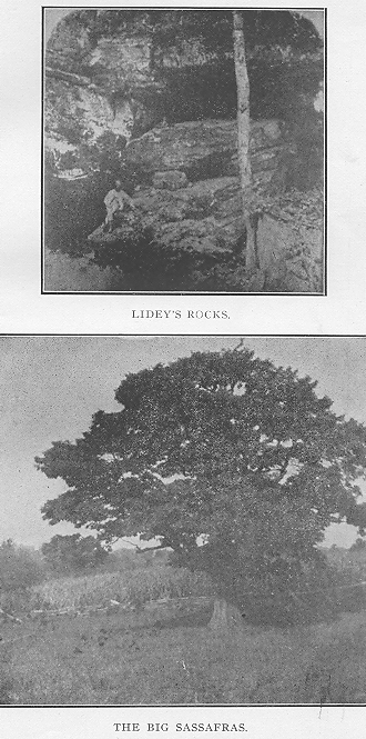
33 - HISTORY OF PERRY COUNTY.


Lidey's Rock.


Among the bits of Natural scenery in our county is Lidey's Rocks, in southern Reading township-. The wildness and picturesqueness of the scene is in sharp contrast to the surrounding country. Here a small stream has eroded the rocks in such a way as to give a person a very good idea of how the water can chisel in minature, thousands of fantastic forms.


These rocks served at one time as a shelter for hunting parties of Indians. Under one of the ledges of rock can yet be seen the mortar in which they cracked their hominy. This locality is now a favorite resort for picnic parties.


The High Rocks.


Near the Old Stone Fort at Glenford, is quite a beautiful example of the erosive power of water. The rocks here belong to the conglomerate series that overlies the Sub-carboniferous or Maxville Limestone. At this place the water has eroded the softer portions away and has left standing tall, Titanic-like pillars that are at least seventy feet in height. The causeways between these masses of rock wind about in devious ways and thereby lend to the enchantment of the place. These rocks are seldom visited, but they deserve more attention, for in many ways they surpass Lidey's Rocks.


The Bear Dens.


In southern Jackson township are the Bear Dens. The mass of sand rock has been left here in a miscellaneously confused heap. There is beneath one of these rocks, a narrow opening which leads to a series


3 H. P. C.


34 - HISTORY OF PERRY COUNTY


of large chambers. It is asserted by old settlers that it was once the haunt of numerous bears when Bruin was monarch of the Perry county woods and wandered through its mazes in search of mast and wild honey.


Why Rushcreek Bottom is so Flat.


In going from New Lexington toward Bremen, one can not help but notice how near to the tops of the hills Rushcreek is. On either side of this valley, the creeks have cut their channels much deeper. Lower Rushcreek is especially flat and marshy, while its entire course is subject to frequent inundations. The reason of this is apparent when we examine the soil :between Junction City and Bremen.


The soil of bottom lands is always the same as that 'of the hills, lining either side. Such is not the case with Rushcreek. This soil is that -of the neighborhood between Rushville and Pleasantville. It accordingly contains considerable "till" and other "drift" materials. At Rushville, Big Rushcreek "rushes" through b. break in the hill which it has made. The narrow pass-:age would cause the water to run swifter at this place. Reaching the flat territory, just south of this "break," the water would spread in every direction. Little Rushcreek would consequently receive a considerable share of this back-water, with its accompanying silt. The water then subsiding very slowly would leave the detritus behind. In this way it is estimated that lower Rushcreek valley was filled to a height of sixty feet.


HISTORY OF PERRY COUNTY - 35


The Mastodon.


The fact that the remains of many Mastodons have been found in Ohio, leads us to the opinion that Perry County must have known about these immense mountains of flesh. After the Ice Age, a dense growth of vegetation sprang up. The Mastodon being herbivbrous would naturally seek for places where food was abundant. Northern Perry would be of especial value to him. The land was swampy ; the vegetation was of quick growth, thus making it toothsome. It is in such places that the remains have been found.


We may be sure that one of his kind once browsed in Thorn township, near the Big Swamp. Parts of his skeleton have been found along Jonathan's Creek. Eleven of his teeth, weighing from ten to seventeen pounds each, adorn the private museums of their finders. A part of a rib, measuring about forty inches has been picked up in the alluvial plain of the Moxahala. As the stream changes its course, other parts of the frame of this ancient Perry county citizen may be unearthed.


Since the above was written, the author has learned that the tooth of one of these mammoth creatures was picked up in the neighborhood of Chapel Hill.


Birds of Perry County.


1. Black Throated Loon — Gavia arcticus.

2. American Merganser — Merganser Americanus.

3. Hooded Merganser — Lophodytes cucullatus.

4. Mallard — Anus boschas.

5. Black Duck Anas obscura.


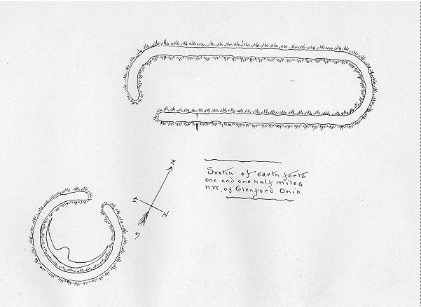
36 - HISTORY OF PERRY COUNTY.


6. Gadwell - Chaulelasmus strepera.

7. Baldpate - Mareca americana.

8. Green-winged Teal - Nettion carolinensis.

9. Blue-winged Teal - Qurquedula discors.

10. Cinnamon Teal - Qurquedula cynoptera.

11. Shoveller - Spatula clypeata.

12. Pintail - Dafila acuta.

13. Wood Duck - Aix Sponsa.

14. Redhead - Aythya americana.

15. Canvas Back-Aythya vallisneria.

16. American Scaup Duck - Aythya marila.

17. Lesser Scaup Duck -- Aythya affinis.

18. Ring-necked Duck - Aythya collaris.

19. American Golden-eye Clangula americana..

20. Barrows' Golden-eye - Clangula islandica.

21. Buffle-head - Charitonetta albeola.

22. Ruddy Duck - Erasmatura j amaicensis.

23. Lesser Snow Goose - Chen hyperborea.

24. Greater Snow Goose -Chen hyperborea nivalis.

25. Blue Goose - Chen caerulescens.

26. American White-fronted Goose - Anser albifrons gambeli.

27. Canada Goose - Branta Canadensis.

28. Brant - Branta bernicla.

29. Sandhill Crane Grus mexicana.

30. Virginia Rail - Rallus virginianus.

31. American woodcock - Philohela minor.

32. Wilson's Snipe - Gallinago delicata.

33. American Golden-plover - Charadrius dominicus.

34. Kildeer - Aegialitis vocifera.

35. Bob-white - Colinus virginianus.

36. Ruffled Grouse-Bonasa umbellus.


HISTORY OF PERRY COUNTY - 37


37. Wild Turkey - Meleagrisgall opavo fera.

38. Mourning Dove - Zenaidura macroura.

39. Turkey V ulture - Cathartes aura.

40. Marsh Hawk - Circus hudsonius.

41. Red-Tailed Hawk - Buteo borealis.

42. Broad-winged Hawk - Buteo platypterus.

43. Pigeon Hawk - Falco Columbarius.

44. American Sparrow Hawk - Falco sparvefius.

45. American .Barn Owl - Strix pratincola.

46. American Coot - Fulica americana.

48. Short-eared Owl - Asio accipitrinus.

49. Screech Owl - Megascops asio.

50. Great Horned Owl - Bubo virginianus.

51. Snowy Owl -.Nyctea nyctea.

52. Black-billed Cuckoo - Coccyzus erythrophthalmus.

53. Belted Kingfisher - Ceryle alcyon.

54. Yellow-bellied Sapsucker - Sphyrapicus varius.

55. Red-headed Woodpecker - Melanerpes erythrocephalus.

56. Northern Flicker - Colaptus auratus luteus.

57. Whip-poor-will - Antrostomus vociferus.

58. Nighthawk - Chordeiles virginianus.

59. Chimney Swift - Chaetura pelagica.

60. Ruby-throated Hummingbird - Trochilus co-lubris

61. Kingbird - Tyrannus tyrannus.

62. Crested Flycatcher - Myiarchus crinitus.

63. Blue Jay - Cyanocitta cristata.

64. American Crow - Corvus americanus.

65. Bobolink - Dolichonyx oryzivorus.

66. Cowbird - Molothrus ater.


38 - HISTORY OF PERRY COUNTY.


67. Yellow-headed Blackbird - Xanthocephalus xanthocephalus.

68. Red-winged Blackbird -Agelaius phoeniceus.

69. Meadowlark - Sturnella magna.

70. Orchard Oriole - Icterus spurius.

71. Baltimore Oriole - Icterus galbula.

72. Rusty Blackbird - Scolecophagus carolinus.

73. Purple Finch - Carpodacus purpureus.

74. American Goldfinch - Astragilinus tristis.

75. Tree Sparrow - Spizella monticola.

76. Swamp Sparrow - Melospiza georgiana.

77. Cardinal - Cardinalis cardinalis,

78. Rose-breasted Grosbeak - Zamelodia ludoviciana.

79. Scarlet Tanager - Piranga erythromelas.

80. Purple Martin - Progne subis.

81. Barn Swallow - Hirundo erythrogaster.

82. Tree Swallow - Tachycineta bicolor.

83. Bank Swallow - Clivicola riparia.

84. Water Thrush - Seiurus noveboracensis.

85. Mockingbird - mimus polyglottos.

86. Catbird - Galeoscoptes carolinensis.

87. Brown Thrasher - Harporhynchus rufus.

88. House Wren - Troglodytes aedon.

89. Wood Thrush - Hylocichla mustelina.

90. American Robin - Merula migratoria.

91. Bluebird - Sialia sialis.

92. Ring-necked Pheasant-Phasianus torquatus.

93. English Sparrow - passer domesticus.

94. Red-bellied Woodpecker - Melanerpes Carolinus.

95. Chipping Sparrow - Spizella socialis.

96. Field Sparrow - Spizella pusilla.

97. Towhee -- Pipilo erythrophthalmus.


HISTORY OF PERRY COUNTY - 39


98. Indigo Bunting - Cyanospiza cyanea.

99. Red-eyed Vireo - Vireo olivaceous.

100. Yellow-throated Vireo- Vireo flavirons.

101. Blue-headed Vireo Vireo solitarius.

102. Yellow Warbler - Dendroica maculosa.

103. Bald Eagle - Haliaectus leucocephalus.

104. Downy Woodpecker - Dryobatespubescens medianus.

105. Bronzed Grackle - Quiscalus quiscula aeneus.

106. Great Blue Heron - Ardea caerula. Green Heron.

107. Whooping Crane - Grus americana.

108. Passenger Pigeon - Ectopistes migratorius.

109. Kentucky Warbler - Geothylpis formosa.

110. White-breasted Nuthatch - Sitta carolinensis.

111. Tufted Titmouse - Parus bicolor.

112. Wood Pewee - Contopus virens.

113 . Phoebe - Savornis phoebe.


Animals.


The virgin forests of Perry county afforded ample haunts for all animals characteristic of this latitude. The woods were full of them. The bear was unquestionably the undisputed monarch of the wilds, as he ambled over our hills and valleys. The panther was a close second in point of rule, as he crouched on the limb of a giant oak, ready to spring upon the timid deer when the latter bounded through the underbrush. Wildcats and catamounts were plentiful. The wolf made the night hideous with his cry. The smaller animals, such as the fox, squirrel, rabbit, raccoon and opossum, fairly swarmed. Wild turkeys made this their feeding ground. Prairie chickens nested and brooded in the tall grass. Pigeons in countless num-


40 - HISTORY OF PERRY COUNTY.


Bers roosted in the tree tops and scores of varieties of other birds twittered and sang and made gay the forest world. In the creeks whole "fleets" of ducks were convoyed by their leader, while in the dark underbrush lay the deadly rattlesnake ready to sound his warning, or the copperhead to strike his fangs into the intruder.


The Indian had not destroyed them all and long after the white man came they were far from being scarce.


Forests.


With but few exceptions the entire area of our county was covered with forests. The oak was the giant, found in every part of the county. It was then as now, the most plentiful of our trees. The oak was not a favorite among the settlers of the county, because, before the days of saw-mills; timber that could be split more easily was utilized. The tall, arrowy poplars or tulip trees, thus came to be the prime favorite for building purposes. There were "chestnut ridges" in every township. On the low lands, the ponderous button-wood or plane-tree changed his coat twice a year. The walnut selected his habitat in the rich soil of the valleys. The shell-bark hickory annually cast its fruitage on the ground. Grape vines threw their trellis work from bough to bough, and each year, paid their tribute to Mother Earth. Nestled in the coves of the hills were hundreds of sugars, through whose veins was coursing the saccharine fluid that had never as yet poured forth its fountain of sweetness. The buckeye grew along the creek banks in the southern townships. Cedars bastioned the rocky hill-sides of Madison where the Moxahala cut its way toward the sea.


HISTORY OF PERRY COUNTY - 41


The flora of the county was profuse. It is said that in the hills, west of Sugar Grove in Fairfield county are a greater number of plant species that can be found in any similar area in Ohio. Lying contiguous to that section, our county partakes of some of its abundance. Lily pads covered the Great Swamp; cranberries grew on its marshy banks, Jack-in-the-pulpits nodded beneath their canopies, bulrushes grew on the creek bottoms, while wild flowers bedecked the mossy ledges and sent out their "sweetness on the desert air." It was a dark, dense world, where only wild animals and wilder men could live. But through the uncounted ages, while empires and dynasties rose and fell, while men strutted about for their brief day on the stage of ancient civilization, the giants of our hills were making ready for the Pioneer's ax and the mould of the wood was gathering slowly for the plow of the Hero of the Forest, who, out of the experiences of the older times, should lay the foundations of a newer and stronger Commonwealth.


THE BIG SASSAFRAS.—What is said to be the largest sassafras tree in Ohio, grows in Section 13 Pike township, near the Dean schoolhouse on the Moxahala road. Its shape is more that of an oak or chestnut than a sassafras, which usually grows tall and crooked. This tree has a girth of over fourteen feet.


Pre-Historic Race.


"As o'er the verdant waste I guide my steed,

Among the high rank grass that sweeps his sides,

The hollow beating of his footsteps seems

A sacrilegious sound. I think of those

Upon whose rest he tramples. Are they here —


42 - HISTORY OF PERRY COUNTY.


The dead of other days? And did the dust

Of those fair solitudes once stir with life

And burn with passion? Let the mighty mounds

That overlook the rivers, or that rise

In the dim forest crowded with old oaks,

Answer. A race, that has long since passed away,

Built them; a disciplined and populous race

Heaped with long toil, the earth, while yet the Greek

Was hewing the Pentelicus to forms

Of symmetry, and rearing on its rock

The glittering Parthenon. These ample fields

Nourished their harvests; here their herds were fed,

When haply by their stalls the bison lowed

And bowed his maned shoulder to the yoke.

All day the desert murmured with their toils,

Till twilight blushed and lovers walked and wooed

In a forgotten language, and old tunes,

From instruments of unremembered form,

Upon the soft winds a voice. The red man came —

The roaming hunter-tribes warlike and fierce,

And the mound builders vanished from the earth."

— Bayard Taylor.


"Who were the Mound Builders ?" This in the minds of most people has never been satisfactorily answered except to the answerers themselves. There are many theories extant. A few are plausible ; many are superlatively nonsensical. Most of the latter are hastily built deductions, based an fragmentary evidence. The remainder are evolved in the fertile and highly imaginative minds of theorists. The origin of the Pre-historic Race of America has been attributed to every nation known to ancient civilization. It has been asserted that they came from the Nile ; that these transplanted Egyptians built the mounds in the western world, in rude copy of the pyramids in the land of the Lotus.


HISTORY OF PERRY COUNTY - 43


Others maintain that they were the lost Children of the tribes of Jacob. Some say they were Phoenicians ; others, Scythians ; while still others are equally certain that they were of Welsh extraction. Voltaire had the evolutionary idea, that it isn't necessary to believe they came from anywhere ; that they were native to the soil the same as the beaver or the bison.


It is not our intention to discuss any of these theories or attempt to answer the original question. It must be said, however, that the subject of archaeology is being studied more systematically than ever and that men are analyzing the subject from a scientific standpoint, and that the "relic hunter" is not now being cited as authority.


It is not out of place, however, to say here, that it is being generally conceded that the mounds and earthworks left by these unknown people are not so old as was formerly believed ; that the Mound Builder and Indian do not belong to different races ; and that the Mound Builders were not such a highly civilized race as has been thought. We have been able to learn only a few of the things concerning these people. All else is conjecture. We know only, that somebody at some time built these strange works. We can only look at them and wonder.


These people lived in our county. They built their mounds and fortifications. We can but describe them as we find them, then the reader can draw his own conclusions. That will be satisfactory to him at least.


There are over a hundred mounds, fortifications, earthworks and village sites in Perry County. The most interesting and best known of these is the "Stone Fort" at Glenford. This fortification belongs to the class of "Hill-top Enclosures," and is the best example


44 - HISTORY OF PERRY COUNTY.


of its kind in the state. Caleb Atwater came over from Circleville about 1840 and then published a glowing description of it in the first book ever written on Ohio Archaeology. Archaeologists from all over the land have visited here and the concensus of opinion is that it is one of the most wonderful of fortifications. This enclosure was evidently erected for defensive purposes. Its area is a fraction over 27 acres. It is made entirely of stone. The pieces are of various sizes. None are larger than what can be easily carried and many are much smaller. The present condition of the walls shows only a win-row of stones. Many have been hauled away. When originally built the wall must have averaged from seven to ten feet in height. The entire length of the rampart is 6,610 feet. Within the enclosure is a stone mound, 100 feet in diameter and 12 feet high.


No stones are found within the enclosure. They were evidently utilized in building the work.


Whoever it was that erected this wall, certainly "knew their business." They took advantage of the natural surroundings. The hill upon which it was built is something over 200 feet above the creek level. The sides of this hill are covered with the conglomerate that overlies the sub-carboniferous limestone. This same stone composes the cap-rock of the hill. Where its stratum appears, water has eroded deep embrasures, thus forming natural passage ways. The loose stones were heaped along the edges of the solid rock, so increasing the height. With the exception of the southeastern corner, the hill has no connection with the surrounding hills. The top could only be reached by climbing the bluffs. At the point, or corner before mentioned, there is a narrow, depressed ridge, leading


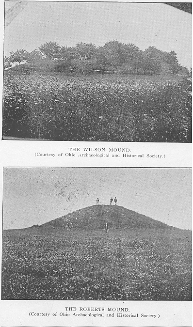
HISTORY OF PERRY COUNTY - 45


to higher ground, beyond. On this higher ground is the Wilson Mound, 18 feet high and covering one acre of ground. From the Wilson Mound can be seen the earth enclosure to the north and the Roberts Mound, east of Glenford. The easiest approach to the fort would have been by the Wilson Mound. The builders, however, took the extra precaution to dig a circular moat and to build a wall to protect this point. The diameter of this moat-enclosure is about 15o feet. Good springs of water are easily reached from the fort. Characteristic flint and stone implements have been found in abundance. If this fort were built for defense there certainly were no bloody battles fought, or the cemetery would be present. At Fort Ancient in Warren County, are two burial places, — one within and one without the fort. None has ever been discovered at the Stone Fort.


The Wilson Mound, mentioned above, is one of the best in the county. It belongs to the "Platform" class of mounds. It has never been thoroughly explored. Several shafts were sunk into it and it was found that the mound was at least half stone. Many of the stones showed signs of fire. A considerable amount of ashes and red clay was found, through which were mingled scraps of bone and pieces of mica.


The Roberts Mound, east of Glenford, is the largest east of the Scioto River. This structure is 120 feet in diameter and 27 feet high. There are no trees upon it, but old settlers say that sixty-five years ago a very large white oak grew upon its crest. This mound is remarkable because a layer of large flat stones was found under the earth and lining the walls. This was for the purpose of holding the wall and preventing


46 - HISTORY OF PERRY COUNTY.


wash. In this mound were found skeletons partly cremated.


Just north of Glenford on a hill about Too feet in height, is a fortification and several mounds. South of the fortification is a circle enclosing a bird with wings outspread. This circle is 652 feet in circumference, 31 feet wide and 4 feet high. The Gateway, 23 feet wide, faces toward the north. The bird effigy from head to tip of tail is 48 feet ; one wing is 122 feet while the other is 1 T T feet. The body is 20 feet wide. The total length from tip to tip is 253 feet. Excavations were made in the bird effigy and ashes were found.


The flint instruments found in the county were all made of Flint Ridge material. Nearly every knoll in the northern part of the county was a workshop. The Perry County mounds do not show the high degree of advancement that the pre-historic inhabitants of the Scioto region evinced. No copper and very little mica has ever been found in our mounds. Everything points to their belonging distinctively to the stone age. At New Lexington could he seen in the flint quarries, places where these former citizens of Perry County secured and shaped the raw material.


The presence of the 'Mound Builders in our county is shown by the following:


Thorn Township has 3 circles. 22 earth mounds, 1, village site, 1, mound group, 1, enclosure.

Hopewell, 10 mounds, 3 enclosures.

Madison, 3 earth mounds.

Reading, 15 earth mounds, 1 village site.

Clayton, 4 earth mounds.

Jackson, 2 earth mounds, 1 stone mound, 1 village site.


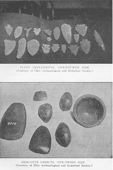
HISTORY OF PERRY COUNTY - 47


Pike, 3 earth mounds.

Saltlick, 1 earth mound.

Monroe, 1 earth mound, 1 stone mound.

Mondaycreek, 3 earth mounds, 1 village site.

Harrison, 5 earth mounds.


Reference has been made to the fact that the prehistoric race belonged to the Stone Age of civilization. The material from which they fashioned their implements came from various sources. The "Drift Region" was amply capable of furnishing all of the granite needed for their axes, celts and gouges. The only difference between a stone axe and a celt is that the axe has a groove for fastening a split stick for a handle, while the celt has no such groove. The latter was used with the hand alone, for stripping the skins from animals or dividing bones at the joints. They were often made from hematite which could be procured in southwestern Ohio or West Virginia. The pestle made from granite is a common find. It is often conical or bell-shaped, made to fit the hand. Its use is too manifest to enter into a description. Corn has been found in these mounds. We conclude, therefore, that one use of these implements was to crack that grain.


Small pieces of hematite, slate and quartz are often found, with grooves cut into their edges, or in the case of slate, a hole is perforated. These were probably used as sinkers, for the Mound Builders really fished. Bone fish hooks have been found in abundance, not in our county, particularly, but in the Scioto Valley.


One of the interesting productions of these people is the ceremonial stones made of slate. They are of various shapes but usually flat. They are, with but few exceptions, perforated. They are known by the dif-


48 - HISTORY OF PERRY COUNTY.


ferent names of Gorgets and Banner Stones. Their purpose was evidently to be worn as amulets.


Their greatest skill was manifested in the manufacture of pipes. The variety of form and decoration was endless. They were made in effigy and symbolized something. The utilitarian idea was not only looked at but the art must be good as well. Possibly the smoking was better when the aesthetic side of their nature was appealed to. These pipes were made to represent human heads, human heads on the bodies of birds, the wild cat, the otter, the buzzard, the eagle, the toad, ground hog, coiled rattlesnake, elk head, etc.


The implements most commonly found in this county are the flint instruments. These consist of arrow-heads, knives, drills, etc.


Flint is the generic name for different forms of silicious matter, such as chalcedony, jasper, hornstone and chert. At Flint Ridge, beds of light and dark jasper are found. Chalcedony, with various tints of blue, red, brown, yellow, white and even green and purple, is plentiful.


The manner of the mining of this was crude but ingenious. The soil was removed to the surface of the flint. In this was put a large fire. When the stone became hot, water was thrown upon it, causing it to shatter. By means of the repetition of this process and the use of hammers, the workman obtained his raw material. Bone hammers with flexible handles, and prongs of deer were then used to chip off the edges. At this they were certainly adept, when we consider the immense number that were manufactured. It is said that a modern Apache Indian could complete an arrow in about six minutes.


HISTORY OF PERRY COUNTY - 49


The Children of the Forest.


It goes without saying that the forests of Perry County were at one time the hunting grounds of the Indian. The lack of navigable streams, possibly deterred it from making for them a permanent home. The valleys of the Muskingum, the Scioto, the Miami and the Maumee were the chief centers of Indian population. The tide of Indian warfare had at different times given this region into either the hands of the Algonquins or Iroquois. When the white man first penetrated the Ohio solitudes, he found the Shawne :s on the banks of the Scioto, the Wyandots on the Sandusky and the Delawares on the Muskingum. At a little later date, we find Wyandots on the lower Muskingum and on the Hock-Hocking. It seems that a portion of the Sandusky Wyandots must have crept through between the Delawares and the Shawnees and made their abode partially in southeastern Ohio. By looking at a map it will be seen that Perry County was in their pathway. The result is that several of the most important "trails" with their tributaries passed through our county. It is certain that Perry County furnished excellent hunting-grounds. Our woods were heavily timbered, our valleys and rocky caverns furnished excellent retreats for game. Our streams were full of fish. There were wild turkeys on Turkey Run, wild pigeons at Pigeon Roost and bears on Bear Run. There were wild ducks at the Great Swamp, while the timid deer placidly slaked his thirst in our brooks or sought the "salt-licks" in the valleys. We can clearly see why the sombre colored native would long to linger in these "happy hunting-grounds making side excursions from the regular beaten "trail."


4 H. P. C.