PART V.
1201 - PIONEER RECORD Of SOUTHERN OHIO.
PIONEER RECORD OF SOUTHERN OHIO.
CHAPTER I.
The Virginia Military District and Its Surveyors-Congressional
Lands in Southern Ohio-Indian Trails, Towns, Camps and
Pioneer Traces in the Virginia Military District in
Southwestern Ohio-The Governor Lucas Mansion
in Pike County, O. The Arcadian Mineral
Springs in Adams County-Rev-
olutionary Soldiers.
THE VIRGINIA MILITARY DISTRICT
embraces twenty-two counties and parts of counties in Ohio, lying between the Scioto and Little Miami rivers, and north of the Ohio river. A part of the western boundary is a line drawn from the source of the Scioto river to the source of the Little Miami river, known as Robert's line. It embraces all of the counties of Adams, Brown, Clermont, Highland, Clinton, Fayette, Madison, and Union; and portions of the counties, Scioto, Pike, Ross, Pickaway, Franklin, Delaware, Marion, Hardin, Auglaize, Logan, Champaign. Clark, Green, Warren and Hamilton. The district is said to cover over six thousand five hundred and seventy square miles, and contains over four million acres of land.
In the second charter of Virginia, which was granted on the 23rd day of May, 1609, this territory, with much more, was granted by King James I., of Great Britain to the Treasurer and Company of Virginia, which included "all !those lands, countries, and territories, situate, lying, and being, in that part of America called Virginia, from the Point of land, called Cape or Point Comfort, all along the sea coast, to the southward two hundred miles, and all that space and circuit of land, lying from the sea coast of the precinct aforesaid, up into the land, throughout from sea Co sea, west, and northwest; and also all the islands, lying within one hundred miles, along the coast of both seas of the precinct aforesaid." Virginia stoutly claimed this land, at all times, by virtue of this charter.
An act of the Legislature of Virginia of October, 1779, 10 vol., Henning's Statutes of Virginia, p. 160, provides for bounties in lands to the officers and soldiers of Virginia in the Revolutionary War, both on Continental and State establishment, and prescriber, the quantity each should receive, according to rank. Prior to the passage of this act, Virginia had promised land bounties to her soldiers of both State and Continental establishment, but the quantity was not definitely fixed until the act last referred to. This act does not prescribe from what particular lands the bounties shall be granted. According to this act the "proportions as have been engaged to them" were as follows: A Private, 200 acres; a Non-commissioned Officer, 400 acres; a Subaltern, 2,000 acres; A Captain, 3,000 acres; a Major. 4,000 acres; a Lieutenant Colonel, 4,500 acres; a Colonel, 5,000 acres; a Brigadier General, 10,000 acres; and a Major General, 15,000 acres.
An act of Virginia, in May, 1779. 10 vol. Henning's Statutes, p. 51, prescribed the manner in which officers and soldiers of Virginia, who served either upon the State or Continental establishment, should procure their land warrants. The modus operandi may be briefly described as follows: In case of a commissioned officer, he procured a certificate from his commanding offrcer that he had served the time prescribed by law, three years, stating his
(1201)
1202 - PIONEER RECORD OF SOUTHERN OHIO
regiment and particular service. Armed with this certiticate, the party applied to the nearest court of record in Virginia and by his own affidavit, or otherwise, satisfied the court of the truth of said certificate. Thereupon the Clerk of the court applied to, made a note of the proof on the original certificate and also in his order book, and annually sent a list of such certificates approved, to the Land office of the State, at Richmond.
With the endorsed certificate, the officer or soldier entitled to the bounty applied to the Register of the Land Office of Virginia, who issued him a warrant, under his hand and seal of office, specifying the quantity of land and the rights upon which it was due, authorizing any surveyor qualified by law to lay off and survey the same, and requiring him to make a record thereof.
There was also a provision in the same act, by virtue of which, a party holding original warrants could lay them in one or more surveys, and where the survey or surveys were insufficient to fill the quantity .named in the warrant, the party was authorized to exchange the original warrant, or warrants, for others calling for the quantity of land not already entered and divided into quantities, in sep rate warrants, to suit the party holding the originals. In this way the name "exchange warrant" originated.
The same act also provided that all persons,. including foreigners, should have the right to transfer warrants, or certificates of survey of lands.
This statute provided also in regard to surplus in surveys, to the effect that no outside party should be permitted to claim the surplus except during the lifetime of the patentee or grantee, and not then in case any sale or conveyance of the land had been made from the patentee or original grantee. The party seeking to enter or take up the surplus must give one year to the party in possession to perfect his title to the surplus by covering it with a proper survey, on the same, or another warrant, and in the case the patentee could not defeat the claim for surplus by a resurvey or otherwise, he, and none other, could assign it in the tract held by him where he saw fit. The act also provided that a surplus of tive per cent should not be regarded.
On the 20th of October, 1783, Virginia ceded all lands owned or claimed by her northwest of the Ohio river, to the United States. This act recited that Congress did on the sixth day of September, 1780, recommend to the several states in the Union, having claims to waste and unappropriated lands in the western country, to cede them to the common benefit of the Union. and that the Commonwealth of Virginia did, on the 2nd day of January, 1781, yield to the Congress of the United States, for the benefit of the said states, all right, title and claim to this territory northwest of the river Ohio. That Congress did by its act of the 13th day of September, 1783, accept the cession; and it was enacted that Thomas Jefferson, Samuel Hardy, Arthur Lee, and James Monroe, delegates to represent the said commonwealth in Congress. should make a conveyance of the same to the United States, which they afterwards did. The act and deed of cession was for the purpose of having states formed out of the territory of not less than one hundred and fifty square miles, or as near thereto as circumstances would admit: and that the states so formed should be distinct republican states, and admitted members of the federal union; having the same rights of sovereignty, freedom and independence, as the other states.
The act further provided that the French inhabitants of the French posts should have their titles confirmed to them, and gave one hundred and fifty thousand acres of land to General George Rogers Clarke, and to the officers and soldiers of his regiment, which was to be laid off in one tract.
There was a condition in the act, that in case the quantity of good lands on the southeast side of the Ohio, upon the waters of the Cumberland river, and between the Green river and Tennessee river, which had been reserved by law to the Virginia troops, upon continental establishment, should, from the North Carolina line bearing in further upon the Cumberland lands than was expected, prove insufficient for their legal bounties, the deficiency should be made up to the said troops in good lands, to be laid off between the river Scioto and Little Miami, on the northwest side of the river Ohio, in such proportions as have been engaged to them by the laws of Virginia.
That all the lands within the territory so ceded to the United States. and not reserved for, or appropriated to, any of the before mentioned purposes,
VIRGINIA MILITARY DISTRICT - 1203
or disposed of in bounties to the officers and soldiers of the American army, should be considered as a common fund for the benefit and use of such of the United States as have become, or should become members of the confederation Or federal alliance of the said states, Virginia inclusive, according to their usual, respective proportions in the general charge and expenditure, and should be faithfully and bona fide disposed of for that purpose, and for no other use or purpose whatsoever. The cession from Virginia was accepted by Congress, March 1, 1784, 1st vol., L. U. S., p. 472.
On the 17th of July, 1788, 1 vol., L. U. S., p. 572, Congress Resolved, That the State of Virginia be requested to inform Congress, whether there has been any deficiency of good lands reserved by the laws of that State on the southeast side of the Ohio, for the Virginia troops on continental establishment, and if so, how much. Afterwards the Legislature of Virginia by a resolution notified Congress that all of it would be required.
By the Act of August 10, 1790, 2 vol., L. U. S., p. 179, Congress opened the district to locations, and authorized the agents of the warrantees to make locations. These were to be entered on a book kept for that purpose. This book was called a Book of Entries. This act also authorized the President of the United States to issue patents; but these patents were to be delivered to the Executive of the State of Virginia, and by him delivered to the grantee.
The Act of May 13, 1800, 3 vol., L. U. S., p. 393, provided that patents might be issued on resolution warrants. There was no limitation under the Law of August 10, 1790, as to when entries should be made and surveys made and returned to the General Land Office; but a number of entries and surveys were made prior to August 10, 1790, and these were made in the counties bordering the Ohio river.
The Act of March 23, 1804, 3 vol., L. U. S., p. 592, provided that the line run under the direction of the Surveyor General of the United States, from the source of the Little Miami towards the source of the Scioto, and which binds, on the east, the surveys of the lands of the United States, shall, together with its course continued to the Scioto river, be considered and held as the westerly boundary line, north of the source of the Little Miami, of the territory reserved by the State of Virginia, between the Little Miami and Scioto Rivers, for the use of the officers and soldiers of the continental line of that State." There was a provision of the act that the State of Virginia should, within two years after the passage of this act, recognize such line as the boundary of the said territory. This act required, in the second Section, that all officers and soldiers should complete their locations within three years after the passage of the act, return their surveys within five years from the passage of the act. An it provided that such portions of the Virginia Military tract as was not located within the time mentioned, should be released from the claims of the soldiers.
A famous act was passed March 2, 1807, 4 vol., L. U. S., p. 92, which provided that the officers and soldiers of the Virginia line, on continential establishment, their heirs or assigns, entitled to bounty lands within the tract reserved by Virginia, between the Little Miami and Scioto rivers, for satisfying the legal bounties to her officers and soldiers upon continental establishment, should be allowed a further time of three years, from the 23rd of March next. to complete their locations, and a further time of five years, from the said 23rd of March next, to return their surveys and warrants, or certified copies of warrants, to the office of the Secretary of War. This act had a famous proviso, called "The Proviso of March 2nd, 1807" which read "that no locations, as aforesaid, within the above mentioned tract, shall after the passing of this act, be made on tracts of land, for which patents had previously been issued, or which had been previously surveyed; and any patent which may, nevertheless, be obtained for land located contrary to the provision of this section, shall be considered as null and void." This famous proviso was construed in the case of Jackson vs. Clark, 1st Peters, 666, in which the decision was rendered by the distinguished Chief Justice Marshall.
The time for making locations and returning surveys was extended by Congress from time to time, as follows:
March 16, 1810, 5 and 7 years, 4 U. S. Laws, p. 281.
1204 - PIONEER RECORD OF SOUTHERN OHIO
November 3, 1814, 3 and 5 years, 4 U. S. Laws, p. 714.
February 22, 1815, 2 years, 4 U. S. Laws, p. 805.
April 11, 1818, 3 years, 1 sess., 15 Cong., p. 37.
February 9, 1821, 2 years, 2 sess., 16 Cong., p. 10.
March 1, 1823, 2 and 4 years, 2 sess., 17 Cong., p. 73.
May 20, 1826, 3 and 5 years, vol. 4 G. S., 189.
April 23, 1830, 2 years, vol. 4, G. S., 396.
March 31, 1832, 7 years, vol. 4, G. S., 500.
July 7, 1838, 2 years, vol. 5, G. S., 262.
August 19, 1841, 3 years, vol. 5, G. S.', 449.
July 29, 1846, 2 years, vol. 9, G. S., p. 41.
July 5, 1848, 2 years, vol. 9, G. S., 245.
February 20, 1850, 2 years, vol. 9, G. S., 421.
May 27, 1880, 3 years, 2 seas., 46 Cong., p. 143.
Each of these Statutes, except the last, which is only one of construction, Substantially re-enacted the proviso of 1807 before referred to.
The Act of March 16, 1810, 4 vol., L. U. S., p. 281, before referred to, reenacted the, proviso of March 2, 1807.
An Act of June 26, 1812, 4 vol., L. U. S., p. 455, provided for three commissioners on the part of the United States, to act with such commissioners as may be appointed by the State of Virginia to establish the westerly boundary line, or rather the line between the head waters of the Little Scioto and Little Miami Rivers.
The commissioners were to be at Xenia on the 5th of October next, and proceed to ascertain, survey, and distinctly mark, the boundary line. There had been a conflict as to the line up to that time, and the commissioners were to employ a surveyor. The act also provided that until the westwardly boundary line of the said reservation should be finally established, by the agreement and consent of the United States and the State of Virginia, the boundary line designated by an act of Congress passed on the twenty-third of March, 1804, should be considered and held as the proper boundary line.
The commissioners on behalf of the United States, ran a line from the source of the Little Miami to the source of the Scioto, and called it Robert’s line. The commissioners appointed by Virginia refused to accede to this line, claiming a still larger tract of land, by running from the source of the Scioto a straight line to the mouth of the Little Miami. The line referred to, in an act of March 23, 1804, p. 133, is designated upon our maps as Ludlow's line. This line was run under the authority of the Surveyor General, by virtue of the act of May 10, 1800. The lands west were surveyed into sections and parts of sections. The territory between these lines, embracing a large tract of 'fertile land, was claimed both by purchase and location, and it became a matter of great importance to the parties. to have established by a judicial decision, the western boundary line of the reservation of Virginia. For this purpose a case was agreed and taken to the Supreme Court of the United States, on error. The cause was decided in 1824, and Robertls line was virtually established. See Doddridge, vs. Thompson, et al. 9 Wheaton 469.
The act of November 3, 1814, before referred to, contained the proviso of March 2, 1807. The same may be said of the Act of February 22, 1815 and the Act of April 11, 1818. The Act of February 9, 1821, and the Act of /March 1, 4823, re-enacted the proviso of March 2, 1807.
An Act was passed May 26, 1824, 1 sess., 18 Cong., p. 121, authorizing the President to ascertain the number of acres, and, by appraisement or otherwise, the value thereof, exclusive of improvements, of all such lands, lying between Ludlow's and Robert's fines, in the State of Ohio, agreeable to the principles of a decision of the Supreme Court of the United States, and to ascertain on what terms the holders will relinquish the same to the United States, and that he report the facts at the commencement of the next session of Congress. The Act of May 20, 1826, above referred to, re-enacted the Proviso of March 2, 1807, but provided in addition that any locations on lands west of Ludlow's line should be void. The last Act extending the time for locations in the Virginia Military District was passed February 20, 1850, Vol. 9 U. S. Statutes, p. 421. This
VIRGINIA MILITARY DISTRICT - 1205
act closed the District to all locations, on the 31st day of December, 1851, and since that time the District has never been open to location.
The Act of August 31, 1852, U. S. Statutes, Vol. 10, p. 143, provided for the relief of an "unsatisfied outstanding warrant," not then located in the United States, in scrip; and this Act was to be deemed in full satisfaction of Virginia Military Land Warrants, and the State of Virginia was required by proper act of the Legislature to relinquish all claims to the lands of the Virginia Military District in the State of Ohio. This was done.
An Act passed December 19, 1854, Vol. 10 U. S. Statutes, p. 98, provided that soldiers who had made entries prior to the 1st of January, 1852, should have two years more to return their surveys and warrants to the General Land Office.
An Act passed. March 3, 1855, U. S. Statutes, Vol. 10, p. 701, allowed officers and soldiers of Virginia on the Continental establishment who had made entries in the Virginia Military District, prior to the 1st of January, 1852, two years longer to make and return their surveys and warrants. This Act repealed the Act last referred to.
In 1871, it was supposed by Congress that there was a great quantity of unsurveyed land in the Virginia Military District, and it was commonly called "vacant land." It was supposed to be worthless, or nearly so, and the United States not desiring to be burdened further with it, and it being no longer locatable under the laws of Congress, the Hon. John T. Wilson, then a Representative of the 11th Congressional District, introduced an act into Congress to cede to the State of Ohio, unsold lands in the Virginia Military District. This Act was approved February 18, 1871, and provided "that lands remaining unsurveyed and unsold in the Virginia Military District in the State of Ohio, be. and the same are hereby ceded to the State of Ohio and saved to any bona fide settler, not exceeding one hundred and sixty acres, by him occupied, by his pre-empting the same in such manner as the State of Ohio might direct. This was conducted through the House by the Hon. John T. Wilson, through the Senate by Senator Thurman. It was supposed to be an innocent act; but it afterwards caused a great deal of trouble. At the time of the passage of this act, it was supposed that if any surveys had been made on these lands. the parties could obtain title and that the surveys would be recognized. That was not only the opinion of laymen in the Virginia Military District, but of lawyers as well. The word "unsold" used in the Act was an improper term, and it should have read "unlocated," as not a foot of land in the District was ever sold, but given away in military bounties.
The State of Ohio ceded this land by an act of the Legislature passed March 26, 1872, to the Trustees of the Ohio State University, and amended the grant on the 3rd of April. 1873, Vol. 70, Ohio Laws. The Board of Trustees of the Ohio State University accepted the grant and began to claim the surplus in the unpatented surveys. It developed that the later surveys in the wild and rough lands invariably contained a large surplus over the amount authorized by the warrant. Sometimes there was four times as much land in the survey as the warrant called for; but this fact could only be determined. by a re-survey of the land. The Board of Trustees of the Ohio State University began to survey unpatented surveys and ascertain the fact of surplus. They thereupon began to tile caveats against the patents and against the holders of the surveys; and there arose a contlict between the holders of the unpatented surveys and the Ohio State University. The original beaters, who were mostly deputy surveyors, had salved their consciences in the act of March 1, 1784, which required the deficiency in Kentucky and Tennessee to be laid off in good lands. They claimed that the locators in the valleys had got the good lands, and when they located in the hills, they having to take inferior lands, would take a great surplus to make the difference in value; but in returning their surveys the distances between the monuments and the calls were always such that when the contents of the surveys were computed, it would not show a surplus of over five per cent. For instance, a call would often be ten rods, when the real distance between the monuments was twenty rods.
The United States Congress was compelled to construe the act of February 18, 1871, and thereupon it passed the act of May 27, 1880, Vol. 21 U, S.
1206 - PIONEER RECORD OF SOUTHERN OHIO
Laws, p. 142, in which it was recited that the act of February 18, 1871 had no reference to lands which were included in any survey or entry within said district, founded upon military warrants upon continental establishment, and that the true intention and meaning of said act was to cede to the State of Ohio lands not included in any surveys, surveyed or entered or founded upon a military warrant or warrants upon continental establishment. Section 2. provided that all surveys returned to the Land Office on or before March 3, 1857, on entries made before Jan. 1, 1852 on unsatisfied Virginia military continental warrants should be valid. Section 3, gave the officers and soldiers of the Virginia Military District, who had before Jan. 1, 1852, entered a tract within the Virginia Military District, three years from the passage of that act to return their surveys for record to the office of the principal surveyor of the district, and to make and file their surveys at the General Land Office. Section 4 of this act, provided_ that the act should not effect any land theretofore sold for a valuable consideration by the Board of Trustees of the State University on the authority of the act of February 18, 1871. This act by construction of the courts was considered ineffective.
But Congress was not satistied, and on August 7, 1882, 22nd Vol. p. 348, passed a law to the effect that any person who had actual open possession in the Virginia Military District of the State of Ohio, under claim of title made in good faith based upon time and entry, of any tract of land within said district, and a record of which was made in the office of the principal surveyor of the Virginia Military District, prior to January 1, 1852, such possession having been continued for twenty years should be deemed to hold an absolute title. Section 2 of said act undertook to repeal so much of the act of February 18, 1871, granting unsold and unsurveyed lands to the State of Ohio, as conflicted with the act of May 27, 1880; but inasmuch as Congress had already granted all its title under the act of February 18, 1871, this act was ineffective and accomplished nothing.
The laymen and the lawyers of the district were entirely taken by surprise by the decision of the Circuit Court of the United States for the northern district of Ohio, in the case of Fussel vs. Gregg. That decision was rendered by Judge Mathews, and while it turned out that it was upon the very best authority, the lawyers generally supposed, at that time, that it was to get rid of Jeremiah Hall, of Circleville, who had been in the habit of finding heirs in Virginia, obtaining assignments of their surveys and rights and securing patents, and as the legal title only began from the date of the patent, he would bring a suit in ejectment, never failing to recover in a case where he had obtained a patent in this manner. He astonished the owners of good lands who had been in possesssion for one hundred years and supposed they had perfect titles. It therefore became necessary to get rid of Jerry Hall and his operations. in the interest of the public. In this case of Fussel vs. Gregg, in the Circuit Court of the United States, the decision was pronounced by Justice Stanley Mathews, who held, that where the surveys had not been returned to the General Land Office, prior to December 31, 1851, they were utterly void, that the locator, or his assigns had forfeited all rights and had no claim as against the Government. That of course left the holders of the warrants to fall back on the scrip law of August 31, 1852, because their warrants were good but their surveys were bad. The decision of the Circuit Court put a quietus on Jerry Hall and his operations; but at the same time it also decided that all lands where the surveys had not been returned to the General Land Office prior to December 31, 1851. belonged to the United States, and passed from the United States to the State of Ohio under the act of February 18, 1871. The case was taken to the Supreme Court of the United States, and was decided there on the 15th day of February, 1885. The case is reported as Fussel vs. Gregg, 113 U. S., 550. The decision came upon the people of the Virginia Military District in Ohio like a thunderbolt out of a clear sky.
The State University went into the Land Office business and undertook to recover all the lands which this decision of February 15 1885, gave it. Wherever the University brought a suit to recover in ejectment a survey which had not been returned to the General Land Office prior to January 1. 1852, it recovered in every instance. The people interested became alarmed,
VIRGINIA MILITARY DISTRICT - 1207
as there was a large quantity of unsurveyed lands in the District. Thereupon they appealed to the Legislature for relief, and on the 14th of March, 1889, that body passed what is known as the "Shinn Law." This act provided that holders of these unpatented surveys, who had occupied themselves, or those under whom they claimed had occupied them for more than twenty-one years, might make application to the Board of Trustees of the University, and obtain a deed on the payment of $2.00, and the State should pay the University $1.00 an acre for their lands. This act was passed on condition that the Board of Trustees of the University should accept it, which it did on the 20th of June, 1889. following.
The act of May 27th, 1880, before referred to. was construed by the Supreme Court of Ohio, in 1882, in the case of Coan vs. Flagg, 38 Ohio State, 156, and again in 1895, the Supreme Court of Ohio, in the case of the Board of Trustees vs. Cuppett, et al, 52 Ohio State, 577, and in Fussel vs. Gregg before mentioned. This decision also construed the act of February 18, 1871 and subsequent acts. This was a settlement of the entire controversy.
The manner of acquiring titles in the Virginia Military District was in substance as follows: A soldier in Virginia would proceed to his County Court armed by the certificate of his superior officer, to the effect that he had rendered the service authorizing the issue of the warrant. He would make proof of his service and identify himself before his County Court, which would issue him a certificate as to the extent of his military service. Armed with this he would proceed to the Virginia Land Office at Richmond, where he would obtain a warrant, authorizing him to locate the quantity of land named in the Virginia Military District. This warrant he would place in the hands of a Deputy Surveyor, who would take it to the Land Office and make an entry in the books of the office, that he proposed to locate so many acres on the warrant issued on account of the service of such a soldier. The Entry recited that he proposed to make the location near a certain survey, or upon a certain stream. After this entry he would proceed upon the land with a Deputy Surveyor, two chain-carriers, a marker and a surveyor's compass, and would make a survey. The Deputy Surveyor would make a written report of this survey, send it to the Virginia Military Land Office, which for a part of the time was at Louisville, Ky., and a part of the time was at Chillicothe, Ohio, where this survey would be recorded and afterwards it was forwarded to Washington with certain certificates by the Principal surveyor. If the papers reached Washington in proper form, a patent was issued.
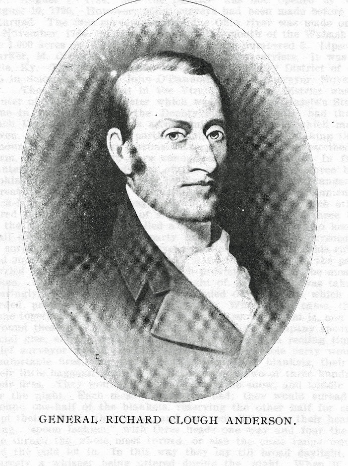
There was usually a Deputy Surveyor in every county of the Virginia Military District. The first surveyor of the District was Gen. Richard Clough Anderson, who kept his office at Louisville, Ky.. and located there as an agent of the Virginia soldiers. He died in October, 1826, and was succeeded by Allen Latham. It was not until the 24th of February, 1829, however, that any surveyor of the Virginia Military District had ever been authorized by law of Congress. On that date the Congress of the United States passed an act creating the office of the Surveyor of the Virginia Military District, and required him to keep his office at Chillicothe. He was authorized to receive all the books, records, etc., relating to the office from the personal representatives of Col. Richard Clough Anderson, deceased, and to take charge of them. The fact of the matter is that the books and papers of Col. Richard Clough Anderson used in locating surveys within the Virginia Military District were his private property. His personal representatives sold the books to Allen Latham, and Latham acted as surveyor, and he sold out his interest to Ebenezer Kendrick of Chillicothe, who was appointed surveyor under the act of February 24, 1829, and held the office until his death in 1885, when his son Samuel was appointed, and surveyed until his death in 1893.
The records of Kendrick’s office were purchased by the United States for tifteen thousand dollars, ($15,000) and taken to Washington, D. C. and put in the General Land Office where they remain. This was done by an act approved March 3, 1899. being part of the Appropriation Bill of that date. The act further provided that all holders of outstanding unsatisfied Virginia military warrants should surrender them to the Secretary of the Interior within twelve months from the passage of the act for his action under the scrip law of Au-
1208 - PIONEER RECORD OF SOUTHERN OHIO.
gust 31, 1852, and that all warrants not so presented within twelve months should be forever barred and held invalid.
The Deputy Surveyors in the District were Elias Langham, John O'Bannon, Arthur Fox, Nathaniel Massie, John Beasley, William Lytle, Cadwallader Wallace, Allen Latham, Robert Todd, Benjamin Hough, Joseph Riggs, E. P. Kendrick, James Taylor, ,Joseph Kerr, James Poage, John Ellison, Jr., John Barrett, William Robe, G. Vinsonhaler and others.
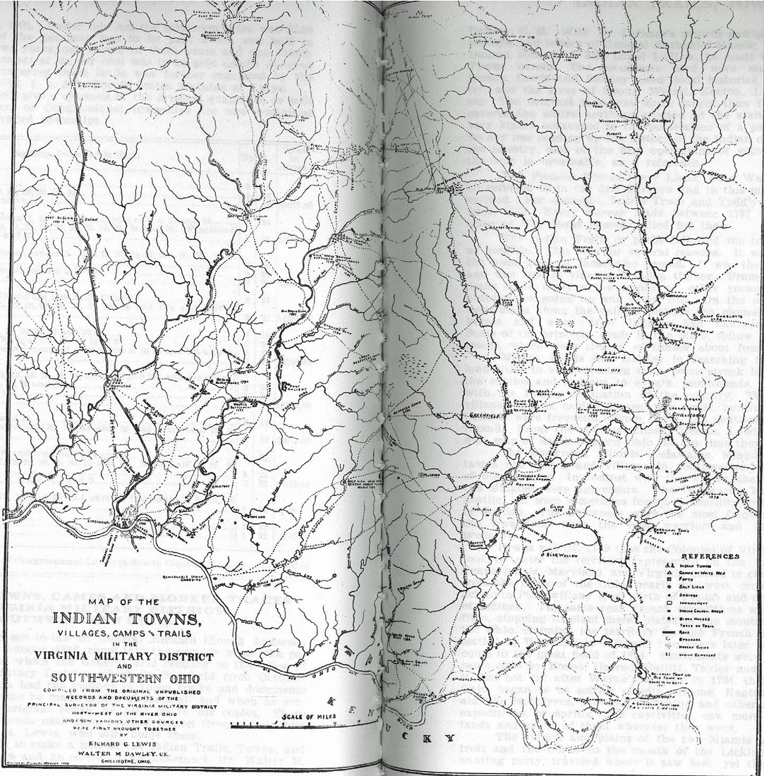
Gen. Richard Clough Anderson, referred to, was appointed principal surveyor of the District by a Board of Officers named in an act of the Virginia Legislature passed in October, 1783. He opened his office in Louisville, Ky., August 1, 1784, but the District was not opened by Congress until August 10, 1790. However, many surveys had been made before that time and returned. The tirst survey north of the Ohio river was made on the 13th day of November, 1784, in Indiana opposite the mouth of the Wabash river. It was for 1,000 acres on Warrant No. 2,219 and was numbered 5. Lipscomb Noel was marker, M. Oliver and I. Designer were chain carriers. It was dated, Louisville, Ky. The first survey in the Virginia Military District of Ohio, was No. 455 in Scioto county by John O'Bannon, Deputy Surveyor, November 16, 1787.
The first settlement in the Virginia Military District was made in the winter of 1790, at Manchester which was then called Massie's Station. At that time in making surveys, the Deputy Surveyor usually had three assistants. Each Deputy Surveyor was accompanied by six men, which made a mess of seven, and four surveying parties would keep together making the whole party amount to twenty-eight persons. Every man had his prescribed duty to perform. Their operations were conducted in this manner: In front went the hunter, who kept in advance of the surveyor two or three hundred yards, looking for game and prepared to give notice should any danger from Indians threaten. Then followed, after the surveyor, the two chainmen, marker, and pack-horse man with the baggage, who always kept near each other, to be prepared for defense in case of an attack. Lastly, two or three hundred yards in the rear, came a man, called a spy, whose duty it was to keep on the back ;trail and look out, lest the party, in advance might be pursued and attacked by surprise. Each man, the surveyor not excepted, carried his rifle, his blanket, and such other articles as he might stand in need of. On the pack-horse were carried the cooking utensils and such provisions as could be most conveniently taken. Nothing like bread was thought of. Some salt was taken, to be used sparingly. For subsistence, they depended on the game which the woods afforded, procured by their unerring rifles. When night came, the four parties came together and four fires were made for cooking, that is, one for each mess. Around these tires, till sleeping time arrived, the company spent their time in social glee, singing songs and telling stories. When resting time arrived, the chief surveyor would give the signal, and the whole party would leave their comfortable tires, and carrying with them their blankets, their firearms, and their little baggage, walk in perfect silence to two or three hundred yards' from
their fires. They would then scrape away the snow, and huddle down together for the night. Each mess formed one bed; they would spread down on the ground one-half of the blankets, reserving the other half for covering. They kept their rifles in their arms, and their pouches under their heads for pillows; lying, "spoon fashion," with three heads one way and four the other. When one turned the whole mess turned, or else the close range would be broken, and the cold let in. In this way they lay till broad daylight, no noise and scarcely a whisper being uttered during the night. When it was perfectly light, the chief surveyor would call up two of the men in whom he had the most confidence and send them to reconnoiter, and make a circuit around the tires, lest an ambuscade might be formed by the Indians to destroy the party as they returned to the fires.
In all surveys made between the Spring of 1791 and Wayne’s victory in 1794, the surveyor took his life in his hand, and expected the crack of an Indian rifle at any time. There was one large survey two miles south of Locust Grove in Adams county, Ohio, which was made during the Indian War in February, 1793. In the early history of the Virginia Military District there was a great deal of litigation, owing to conflicting surveys, and much legal learning
VIRGINIA MILITARY DISTRICT - 1209
has been accumulated in the Reports, on the doctrine of conflicting titles in the Virginia Military District Of the lawyers who were prominent in this litigation, there were Vachel Worthington, Sr., of Cincinnati; Allen G. Thurman, of Chillicothe and Columbus; James H. Thompson, of Hillsboro, 0.; Benjamin Leonard, of Chillicothe; Edward P. Evans, of Adams county; Hocking H. Hunter of Franklin county, and Henry Fulsom Page, of Circleville, Ohio; but the litigation as to conflicting grants in the Virginia Military District have simply become history, as all the lines have been settled.
General Richard Clough Anderson,
Principal Surveyor of the Virginia lands to pay the Continental troops, was born upon his father's estate of "Goldmine," Hanover county, Virginia, January 12, 1750. and died at his country place "Soldier’s Retreat,” near Louisville, Kentucky, October 6, 1826. Upon the 26th day of January, 1776, he was appointed Captain of the Hanover county Company in the Fifth Virginia Regiment of the Continental Line. In this capacity he took a prominent part in the battle of Trenton, for it was his attack upon the outposts on the night before the general engagement a movement ordered by General Stephan in direct opposition to General Washington's commands, that led the Hessians to believe they had repulsed the threatened assault and led them to be careless in their watch. Captain Anderson was wounded severely in the engagement at Trenton bridge, which closely followed the battle of Trenton, and General Arthur St. Clair told Judge Yaple that his conduct in this campaign won for Captain Anderson the respect and friendship of General Washington. Captain Anderson served with the Fifth Virginia in the battles of Brandywine and Germantown. On the 10th day of February, 1778, he was promoted to be Major of the First Virginia Continental Line. With this command he took part in the battle of Monmouth.
Major Anderson accompanied the Count D'Estaing in the attempt to reduce Savannah and he was severely wounded in the shoulder, during the assault, by a sword thrust from "his friend the enemy" Captain James of the British service, James having been formerly on terms of intimacy with Anderson. Major Anderson was surrendered at Charleston when serving with Scott's brigade, and for nine months suffered many privations, as a prisoner of war. Upon his release he joined General Morgan, and was with him on his retreat through the Carolinas. Upon his arrival at Richmond, he found an order directing him to report to General, the Marquis de Lafayette, as it was supposed that Major Andersonsis intimate knowledge of the country would prove of assistance to the Marquis in determining his movements. Major Anderson served for six months on the staff of the Marquis de Lafayette, and then as Lieutenant Colonel of the Sixth Virginia Continentai Line and Brigadier General of Virginia Militia, he was directed to report to Governor Nelson of Virginia. There are letters from the Marquis de Lafayette and others in the Cincinnati Art Museum showing the high opinion the Marquis had for the subject of this sketch.
In October, 1783, the Legislature of Virginia passed a law appointing Major Generals Peter Muhlenberg, Charles Scott and George Weden, Brigadier Generals, Daniel Morgan and James Wood, Colonel William Heft, Lieutenant Colonels Stowles, Hopkins, Clarke, Temples and Captains Nathaniel Burwell and Mayo Carrington, a commission to appoint a Surveyor for the Virginia Military District. They appointed Colonel Richard Clough Anderson, and it was under this law that he acted in such office until his death.
The office of the Surveyor of the Virginia Military District was opened July 20, 1784, at the falls of the Ohio, now the City of Louisville. Colonel Anderson was then a pioneer, and with General George Rogers Clarke and other such spirits he did much to open up the Western country. In 1787, Colonel Anderson married a sister of General George Rogers Clarke, and the next year he built a log house ten miles from the falls, and with his wife, a babe, and some negro servants, moved into the wilderness. Here Colonel Anderson could gratify his taste for the chase, but the most fearless would hardly consider "Soldierls Retreat" a very safe refuge. His nearest neighbors, at Linn's Station, were live miles away, and in another direction, but a little further
1210 - PIONEER RECORD OF SOUTHERN OHIO.
removed, lived Captain Chenoweth. No record has been left of the heedless travelers who fell victims to the murderous redmen of this region, but so wary a backwoodsman as Colonel Linn was killed by a wandering party of Indians within half a mile of Colonel Andersonls house, and the Chenoweth Massacre is one of the noted horrors of those early Kentucky days.
On the 16th day of October, 1826, after a painful illness, borne with characteristic fortitude, Colonel Anderson gave up his life, which, though passed in unceasing labor, and amidst great and constant perils, must be held to have been a happy one. He was at an early age inured to the hardships that the soldier and the pioneer must undergo, and he found pleasure in the excitements of the camp and of the border. Although he never held a political office, his career was a public one, and he was thoroughly respected. He lived long enough to see his children exhibit characters which promised to reflect credit upon him.
He had six sons: Richard twice represented his district in the National Congress, was Minister to the United States of Columbia, and died, greatly regretted, at Carthagena. on his way to the Congress at Panama, as Commissioner; Larz Anderson, of Cincinnati, a scholar and the conscientious steward of his large. fortune; General Robert Anderson of Fort Sumpter; William Marshall Anderson, one of the first to cross the Rocky Mountains, and who, when three score years of age, made a scientific journey through Mexico; John Anderson of Chillicothe, and Charles Anderson, who at the risk of his life, made the speech before the secession meeting at San Antonio, in 1861, in favor of sustaining the Union. The five last named children were from a second marriage with Sarah Marshall daughter of William Marshall, of Caroline county, Virginia, a niece of the first wife.
Allen Latham
was born in Lyme, New Hampshire, in March, 1793. He was a graduate of Dartmouth College in 1813 and came to Ohio and was admitted to the bar at New Philadelphia. He then removed to the old State Capitol, Chillicothe, in 1815. He was married to Maria W. Anderson, daughter of Colonel Richard C. Anderson. They had one son who died at the age of twelve years. Allen Latham was the Surveyor of the Virginia Military District from 1826 to 1838 as the representative of Col. Anderson. He was always a democrat. He represented Ross, Pike, Jackson and Hocking counties from 1841 to 1843 in the State Senate. In 1838, he was defeated for Congress by 138 votes. He removed to Cincinnati in 1854 to help out a nephew who was engaged in operating an omnibus line and remained there until his death. He died March 28, 1871.
William Marshall Anderson
was the son of General Richard Clough Anderson. He was born in Jefferson county, Kentucky, in 1807. He was a graduate of Transylvania University in Kentucky. He studied law but never practiced it. When his father died in 1826, he assisted in the Surveyor's office of the Virginia Military District, though it was controlled by Allen Latham as one of the personal representatives of Colonel Richard Clough Anderson, from 1826 to 1838. In 1834, he went overland to Salt Lake and returned. He accompanied a party of trappers. On October 12, 1838 he was temporarily appointed Surveyor of the Virginia Military District in Ohio and permanently appointed January 21, 1839. He served until January, 1848. when he was succeeded by Eleazer P. Kendrick. In 1838, he married Eliza, daughter of Gen. Duncan McArthur and made his home near Chillicothe and later in Pickaway county, where he died in 1881. He was a student all his life. He was an archaeologist and an explorer. In his old age, he made a trip through Mexico to study Aztec antiquities. He at one time owned the "Raven Rock" farm below Portsmouth, now owned by William B. Grice.
Eleazer Porter Kendrick
was born in Hanover, New Hampshire, September 16, 1790, the youngest of six brothers. He attended Moore's school at Hanover afterwards Dartmouth College. At eighteen he began teaching school and kept it up three months. What he did from 1808 till 1818 is not reported to us. In the latter year he
VIRGINIA MILITARY DISTRICT - 1211
taught a school in Troy, New York. 1n 1819, he came to Ohio, at the instance. of Allen Latham, an old schoolmate. He opened a shoe store in Chillicothe, but closed it in 1821. He became a Deputy Surveyor under Allen Latham, from 1826 to 1838, and a dealer in Virginia Military Lands and assisted him in the Surveyor's office from time to time until 1847, when he purchased the books and papers of the Anderson estate and on June 14, 1847, was made Surveyor of the Virginia Military District. He held that office until his death, although for the last fifteen years of his life, the duties of the office were discharged by his son, Samuel.
He was a democrat all of his days. He was postmaster at Chillicothe, Ohio, from 1829 to 1841. He was Surveyor of Ross county in 1828. for one term. Allen G. Thurman was a clerk in the Chillicothe postoffice under him, as was Daniel Gregg. He was a communicant and vestryman of St. Paul's P. E. church of Chillicothe. He was senior warden of the church many years. He was president of the Ohio Insurance Company and at one time a director of the Ross County Bank. He was a Mason and a Knight Templar, but demitted long before his death. The last twenty years of his life he spent at his country home on the Milford and Chillicothe turnpike, near Chillicothe, Ohio. He enjoyed the confidence of the public all his life.
He was married in Chillicothe, Ohio, March 20, 1821, to Miss Mary Cissna Beard, who died September 4, 1870. They had seven children, three sons and four daughters. Their son, Andrew D., well known in the Virginia Military District, was horn December 31, 1821, and died May 19, 1857. Their son, Samuel, succeeded his father in the office. Mr. Kendrick died April 30, 1885.
Sam Kendrick
the last Principal Surveyor of the Virginia Military District, was born at Chillicothe on December 31, 1829. The sketch of his father, Eleazer Porter Kendrick, precedes this.
Sam Kendrick attended school for a while at Gambier, Ohio, and then studied civil engineering with his father at Chillicothe, and rapidly acquired proficency in his profession. He was one of the corps of engineers who located the old Cincinnati & Belpre railroad in the early fifties, and while so engaged be met and married, on April 25, 1852. Miss Eliza Wilson, at New Vienna, Ohio.
After his marriage he moved with his wife to Iowa and lived there about five years, and then returned to Chillicothe, where he found employment as Deputy Auditor, under his father, who had meanwhile been elected Auditor of Ross county. In March, 1863, he succeeded his father as Auditor for one term, but was elected to the office again in the fall of 1866, and served as Auditor of Ross county continually until 1871.
Meanwhile his father had made over to him all of the books and papers relating to the records of the lands of the Virginia Military District in Ohio; which records and papers had been held by the courts to be the private property of the Principal Surveyor. After leaving the Auditor's office, Mr. Kendrick devoted himself largely to matters relating to business growing out of the land titles in the Military District; and finally offered to sell the records of his office, first to the State of Ohio, and then to the United States government. It was while in Washington upon the latter business that he died suddenly on January 4, 1893.
Mr. Kendrick was a large man, and in the latter years of his life grew to be somewhat unwieldly in size. He was a man of keen wit, and kindly humor, a genial companion and an entertaining talker. He was fond of all the good things of life, not omitting the intellectual. He was a great reader, a man of strong and retentive memory and thus acquired a large fund of information. He was a man of courteous and popular manners, and very popular as a political leader in Ross county, where he was a long while a prominent member of the Democratic party. His wife and seven children survived him, frve sons and two daughters, viz:—Thomas, Sam, Charles, Albert and Robert; Anna, married to John M. Reed; and Fannie.
He was a prominent member of the Masonic orders, and by them his funeral was conducted and his remains interred in beautiful "Grandview" cemetery at Chillicothe.
1212 - PIONEER RECORD OF SOUTHERN OHIO
CONGRESSIONAL LANDS OF SOUTHERN OHIO.
The present system of survey of the public lands was inaugurated by a committee appointed by the Continental Congress consisting of the following delegates: Thomas Jefferson, chairman, Virginia; Hugh Williamson, North Carolina; David Howell, Rhode Island; Elbridge Gerry, Massachusetts; Jacob Real, South Carolina. On the 7th day of May, 1784, the committee reported "An ordinance for ascertaining the mode of locating and disposing of lands in the western territory and for other purposes therein mentioned." This ordinance required the public lands to be divided into "hundreds" of ten geographical miles square and those again to be sub-divided into lots one mile square each to be numbered from 1 to 100 commencing in the northwestern corner and continuing from west to east and from east to west consecutively. This ordinance was considered, debated and amended, and reported to Congress April 26, 1785.
It required the surveyors to divide the said territory into townships of seven miles square by lines running due north and south and others crossing these at right angles. These were to be sub-divided into sections of one mile square or 640 acres and numbered from 1 to 49. This is the first record of the rise of the terms "township" and "section." May 3, 1785, on motion of William Grayson and seconded by James Monroe, this ordinance was amended by making the township "six miles square," but left the number from 1 to 49. An amendment on May 6, 1785, to change the numbers so that a township should contain 36 sections was defeated, but, on May 20, 1785, this ordinance was finally passed providing for townships six miles square containing 36 sections' one mile square. The act of May 18, 1796, amended said ordinance by beginning with number 1 in the northeast section and proceeding west and east alternately through the township with progressive numbers until the thirty-sixth be completed and is the southeast section of said townships. An ordinance for ascertaining the mode of disposing of land in the Western territory, passed May 20, 1785, directs the manner of surveying the territory ceded by individual states.
The surveys of the government lands were commenced in July. 1786, under the management of Thomas Hutchins, the geographer of the United States, who continued in said office until his death in April, 1789, after which the entire management of the surveys devolved upon the Board of the Treasury until the Act of Congress approved May 18, 1796, provided for the appointment of a Surveyor General and directed the survey of the lands northwest of the Ohio river and above the mouth of the Kentucky river. In 1799, the surveys were again placed in charge of a special officer with the title of Surveyor General, according to the above ordinance, and General Rufus Putnam, of Marietta, Ohio, was appointed to this office, which he held until the State of Ohio was admitted into the Union. In 1803, he was succeeded by Jared Mansfield of the United States Military Engineers. But the credit for the present system of surveying the public lands into ranges, townships and sections is due to Hutchins who conceived the idea in 1764.
The first surveys of the Congressional lands in Scioto county was made under the Act of May 18, 1796, which provided that the land not already surveyed should be divided into townships, six miles square, by north and south lines run by the true meridan and six miles apart, called range lines and by parallels or township lines run east and west every six miles, connecting said range lines, making said townships six miles each way. The ranges are six miles wide and are numbered from east to west, from one upward, beginning with No. 1 bordering on the west side of the state line between Ohio and Pennsylvania and increasing westward, while the townships are numbered from one upward, beginning on the Ohio river as a base line and numbering northward consecutively to the south line of the United States Military land whose southwest corner is near Marble Cliff on the Scioto river in Franklin county, northwest of Columbus.
Under this Act one half of the townships surveyed were to be sub-divided into sections, by running through the same, each way, parallel lines at the end of every two miles, and by making a corner on each of said lines at the end of every mile," and it further provided that "the sections shall be numbered re-
CONGRESSIONAL LANDS - 1213
spectively, beginning with number one in the northeast and proceeding west and east alternately, through the township, with progressive numbers till the thirty-sixth be completed which will be the one in the southeast corner of said township." This method of numbering sections is still in use, although there have been some improvements adopted in the field work in establishing the meridians and parallels and in sub-dividing the interior of said townships into sections. The intention of the law was to sub-divide the interior of said townships into two mile blocks by runnng parallel lines north and south and east and west at every two miles from one township line to the other, also from one range line to the other making straight .lines clear through the township, but from the topographical records left by those surveyors it appears that they were not so sub-divided, but that each two mile block was surveyed separately.
The Congressional lines within Scioto county lie in ranges 18 to 22 inclusive, and townships 1 to 5, inclusive. The survey of these lands into two mile blocks according to the above act of Congress, was made during the year 1799, by Elias Langham, except perhaps, the eastern part of Madison township, which was surveyed by Levi Whipple. The Act of Congress of February 11, 1805, provided that the townships surveyed and divided into two mile blocks according to the Act of May 18, 1796, should be further sub-divided and that the sub-division into sections, as provided for by said Act of 1796, be made by running straight lines from the mile 'corners, previously marked, to the opposite corresponding corners, and by marking on each of said lines, intermediate corresponding corners, as nearly as possible, equidistant from those two corners that stand on the same line, and in this way, by actual survey, divide the township into sections and quarter sections and mark the half and quarter section corners. The point where these two lines, crossing said two mile blocks at right angles, intersect, will be the true corner to the four sections within said two mile blocks. The sub-division of the lands in Scioto county under the Act of February 11, 1805, was made by James Denny in the year 1805.
The following diagram will clearly illustrate how the land was surveyed and sub-divided under the two acts above referred to. The heavy lines and corners are the boundaries of the two mile blocks as surveyed by Elias Langham, and the tiner lines are those surveyed and established by James Denny.